11-30-19
Kim
joined me for a double feature. Two hikes in one day. With the
Thanksgiving holiday this would be my third hiking day in a row. For my
first hike it was 26 degrees when I started. Day two it was 28 degrees.
We did not aim for a very early start to allow for at least a little
warming. We met in North Seattle at 8:30 am and headed east. We left
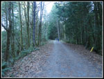
I-90 and headed up the Middle Fork Snoqualmie River Road. The outer
parking lot for Mailbox Peak was half empty. All along the road the
trees were white with frost. At the end of pavement we quickly crossed
the bridge over the Taylor River and found the parking lot. There were
quite a few cars though many open spots too. We parked near the
outhouse. The trail starts right behind it. The sky was clear and it
was 26 degrees. Even with a heavy polypro layer and wool shirt it was
chilly. We headed up the new trail at 9:35 am.
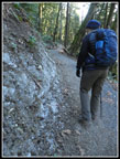
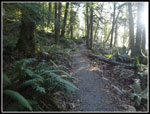
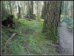
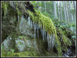
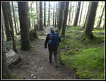
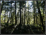
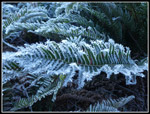
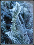
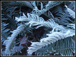
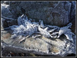
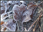
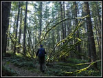
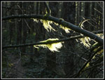
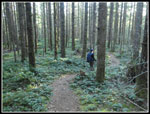
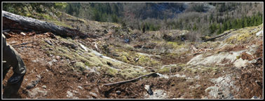
The Garfield Ledges Trail has just opened. I did not see any notes when it opened but when I checked at the end of summer there were still work parties going on. It is a short trail. Just about two miles round trip with about 675' of elevation gain. Hence the need for another trip. It is too short for a full day's hiking. Lots of ice along the trail. we saw ice dirt, hair ice, and icicles. We were in no hurry and made lots of photos stops. Real quickly I decided that I needed another layer even for the climb. On went my jacket. As we ascended out of the valley bottom it did warm up noticeably.
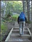
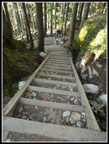
There were other parties going up and even coming down already. The trail is nicely graded with two steep stairways one right after the other. About half a mile up I realized I did not hang my NW Forest Park pass. Now that the road is paved it is easy for the forest service to check for permits. The fine is high enough that I decided to go on back down. It is a short trail. It did not take long to get down, hang the pass, and hike back up. I now had an extra mile and 400' of elevation gain for the day. By the time I reached the ledges Kim was already there with several other groups. The space is not huge but we had plenty of room.
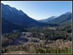
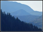
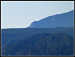
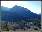
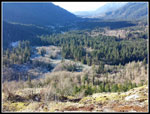
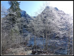
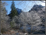
Views out are really good. We could see Stegosaurus Butte right across the valley. To the right I could pick out South Bessemer Mountain. The valley of Taylor river is sharply to the right. To the left is the Middle Fork heading upriver. The confluence of the MF and Taylor is right below. Far off in the distance is Rattlesnake Mountain and Cedar Butte. Our next destination could be seen. Right at the Ledge the trail leaves forest and we were bathed in sunshine. It was much warmer in the sunshine. I even took my gloves off. We really did not want to go back into the colder forest.
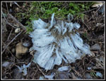
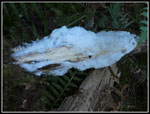
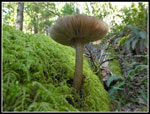
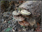
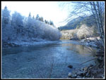
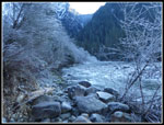
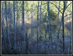
I arrived at 10:51 am. We finally packed up to leave at 11:40 am. The trip down was much faster. Some ice had melted. Still lots of mushrooms and other fungi to enjoy. The lot was just about full. On the drive out we stopped at one of the small parking spaces along the road. We were right near the river. All the leafless deciduous trees along the river were still coated in frost. Very picturesque. Along with the river all the ferns, and rocks, and most everything else had a coating of white. Still in the mid 20s but very nice.
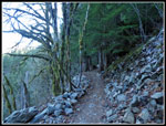
Now we headed out of the valley. The afternoon forecast near North Bend called for winds in the mid teens. With the cold weather that much wind might cause us to abort part two of the trip. There was quite a bit of wind as we drove up to Rattlesnake Lake. The state park lot was half empty. The lots across the road for Rattlesnake Ledges was full. There were a lot fewer cars parked along the road than expected. Perhaps the very cold temperatures kept some folks at home. We could hear wind up above but it was not bad at the trailhead. We decided to give it a shot. Up to the Iron Horse State Park railroad grade we went. There were other folks out no the grade.
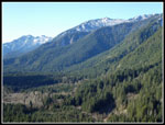
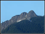
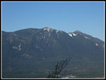
The first .90 miles on the grade have minimal elevation grade. It goes by quickly. The signed trail for Cedar Butte is short but moderately steep. Up we went. Several groups passed us going up and others were coming down. Not crowded but we saw at least half a dozen groups. The one junction is still not signed. We went left on the shorter trail to the summit. We took a short break at Summit Junction then headed on up. Lots of switchbacks brought us up to the top at 1880'. Still low enough to by snow free. Several groups passed us going down just before the top. We were along at the summit. We could see down the valley of the MF Snoqualmie but had no idea exactly where the Garfield Ledges trail is located. A week earlier I hiked up to a snow free Mt. Teneriffe summit. Now it is very snowy. It was still clear for great views of Mt. Si, Mailbox Peak and many others. Though we never did have high winds there was enough breeze to be very cold on top. We did not stay there long. Just as well as others were nearing the summit.
On the way down we stopped at Summit Junction and took the Boxley Blowout Trail. This one is half a mile longer but much less steep. It goes right to the edge of the big drop off created when a slide created a short lasting flood that took out the mill town of Edgewick in 1918. Now the forest is so thick that its hard to see much below. We completed the loop and continued down the Cedar Butte Trail to the railroad grade. Then we just had the flat walk back to the trailhead. We were back at the car at 4:00 pm.
For the day I hiked 7 miles with 2000' of elevation gain. As mentioned some of that was because of hiking the lower Garfield Ledges Trail twice. It was my third consecutive day of well below freezing hikes. I will not be sad to see the warmer though wetter weather return. Just not too wet. It was Kim's first hike in a while and she did great. One new trail for me and two for Kim. Both of these trips are short enough for folks who seldom hike. The Garfield Ledges Trail will soon be very popular. Cedar Butte has been discovered but will likely never be crowded. Two great hikes in one day and 25 miles with 5700' of gain for the three days. Last weekend I went over 200,000' of elevation gain for the year and the day before this hike I went over 800 miles. It is now a very good hiking year with a whole month to go.
Click on thumbnails to get
larger pictures.
Trips - 2019
Home
The Garfield Ledges Trail has just opened. I did not see any notes when it opened but when I checked at the end of summer there were still work parties going on. It is a short trail. Just about two miles round trip with about 675' of elevation gain. Hence the need for another trip. It is too short for a full day's hiking. Lots of ice along the trail. we saw ice dirt, hair ice, and icicles. We were in no hurry and made lots of photos stops. Real quickly I decided that I needed another layer even for the climb. On went my jacket. As we ascended out of the valley bottom it did warm up noticeably.
There were other parties going up and even coming down already. The trail is nicely graded with two steep stairways one right after the other. About half a mile up I realized I did not hang my NW Forest Park pass. Now that the road is paved it is easy for the forest service to check for permits. The fine is high enough that I decided to go on back down. It is a short trail. It did not take long to get down, hang the pass, and hike back up. I now had an extra mile and 400' of elevation gain for the day. By the time I reached the ledges Kim was already there with several other groups. The space is not huge but we had plenty of room.
Views out are really good. We could see Stegosaurus Butte right across the valley. To the right I could pick out South Bessemer Mountain. The valley of Taylor river is sharply to the right. To the left is the Middle Fork heading upriver. The confluence of the MF and Taylor is right below. Far off in the distance is Rattlesnake Mountain and Cedar Butte. Our next destination could be seen. Right at the Ledge the trail leaves forest and we were bathed in sunshine. It was much warmer in the sunshine. I even took my gloves off. We really did not want to go back into the colder forest.
I arrived at 10:51 am. We finally packed up to leave at 11:40 am. The trip down was much faster. Some ice had melted. Still lots of mushrooms and other fungi to enjoy. The lot was just about full. On the drive out we stopped at one of the small parking spaces along the road. We were right near the river. All the leafless deciduous trees along the river were still coated in frost. Very picturesque. Along with the river all the ferns, and rocks, and most everything else had a coating of white. Still in the mid 20s but very nice.
Now we headed out of the valley. The afternoon forecast near North Bend called for winds in the mid teens. With the cold weather that much wind might cause us to abort part two of the trip. There was quite a bit of wind as we drove up to Rattlesnake Lake. The state park lot was half empty. The lots across the road for Rattlesnake Ledges was full. There were a lot fewer cars parked along the road than expected. Perhaps the very cold temperatures kept some folks at home. We could hear wind up above but it was not bad at the trailhead. We decided to give it a shot. Up to the Iron Horse State Park railroad grade we went. There were other folks out no the grade.
The first .90 miles on the grade have minimal elevation grade. It goes by quickly. The signed trail for Cedar Butte is short but moderately steep. Up we went. Several groups passed us going up and others were coming down. Not crowded but we saw at least half a dozen groups. The one junction is still not signed. We went left on the shorter trail to the summit. We took a short break at Summit Junction then headed on up. Lots of switchbacks brought us up to the top at 1880'. Still low enough to by snow free. Several groups passed us going down just before the top. We were along at the summit. We could see down the valley of the MF Snoqualmie but had no idea exactly where the Garfield Ledges trail is located. A week earlier I hiked up to a snow free Mt. Teneriffe summit. Now it is very snowy. It was still clear for great views of Mt. Si, Mailbox Peak and many others. Though we never did have high winds there was enough breeze to be very cold on top. We did not stay there long. Just as well as others were nearing the summit.
On the way down we stopped at Summit Junction and took the Boxley Blowout Trail. This one is half a mile longer but much less steep. It goes right to the edge of the big drop off created when a slide created a short lasting flood that took out the mill town of Edgewick in 1918. Now the forest is so thick that its hard to see much below. We completed the loop and continued down the Cedar Butte Trail to the railroad grade. Then we just had the flat walk back to the trailhead. We were back at the car at 4:00 pm.
For the day I hiked 7 miles with 2000' of elevation gain. As mentioned some of that was because of hiking the lower Garfield Ledges Trail twice. It was my third consecutive day of well below freezing hikes. I will not be sad to see the warmer though wetter weather return. Just not too wet. It was Kim's first hike in a while and she did great. One new trail for me and two for Kim. Both of these trips are short enough for folks who seldom hike. The Garfield Ledges Trail will soon be very popular. Cedar Butte has been discovered but will likely never be crowded. Two great hikes in one day and 25 miles with 5700' of gain for the three days. Last weekend I went over 200,000' of elevation gain for the year and the day before this hike I went over 800 miles. It is now a very good hiking year with a whole month to go.
 Icy Slope |
 Gravel At First |
 Lots of Ice |
 Hair Ice |
 Mossy Ground |
 Kim On Stairs |
 Icicles |
 Out Of Forest |
 View From Ledges |
 South Bessemer Mt. |
 Distant Cedar Butte |
 Rattlesnake Ledges |
 Stegosaurus Butte |
 Rivers Confluence |
 Heading Down |
 Steep Steps |
 Mushroom |
 Light & Dark |
 Shelf Fungi |
 Frosty Trees Along River |
 Looking Up River |
 Frosted Ferns |
 More Ferns |
 Nice Lighting |
 Icy Leaves On Rock |
 Frosted Leaves |
 Bright Branches |
 Peaks Over Trees |
 Railroad Grade |
 Frozen Pond |
 Mt. Si? |
 Ceder Butt |
 Mt. Teneriffe |
 Mossy Limbs |
 Glowing Moss |
 Lots Of Salal |
 Panorama Of Garfield Ledges |
Trips - 2019
Home