11-23-19
I
planned a drive east to Cle Elum for a long flat hike along the Yakima
River. It would be cold but with some sunshine. The west side looked to
be darker and damper. Late the night before the it looked to be clearer
near North Bend. In the morning I decided to go for the shorter drive
and much more elevation gain with a trip up Mt. Teneriffe. Clouds in
Seattle gave way to completely blue sky in North Bend. So far so good.
I arrived at the fairly new trailhead at 7:40 am. Two groups started
just a head of me. I was on the trail by 7:46 am. My first trip up Mt.
Teneriffe was in 1994 on a March day with lots of snow up high. The old
trailhead only held about 8-9 cars. There was no Internet and almost no
write up. Just a short description in a book called Footsore that was
already well out of print. I followed the road then the ridge and made
it to the summit. My last visit was in January 2015. Almost no now that
time. The road had just been decommissioned and made more trail like.
The new parking lot was not yet built. On my first visit the route up
via Kamikaze Falls was unknown if it existed. Much has changed.
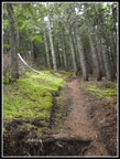
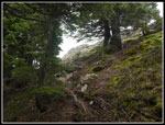
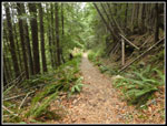
This was my first time at the new parking lot and on the new half mile trail that connects with the old road. A nice trail and much softer tread than the old gravel road. Before reaching the junction I passed one hiker. Now back on the old road I continued on. Just after the signed junction for the falls I passed the second group of three hikers. The next mile is nearly flat as I sped up. I reached 1.5 miles in 30 minutes. The grade immediately begins to climb. After a short climb I stopped to replace a polypro layer and wool shirt with a light long sleeve shirt. It was now about 40 degrees and the consistent climbing kept me warm.
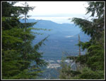
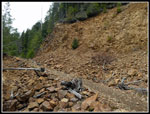
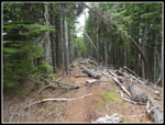
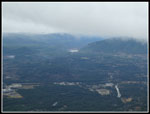
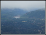
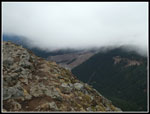
The road/trail conversion looks much better almost five years later. Much of the way has narrowed down to wide trail width. Not nearly as wide as it once was. It is still a bit rocky in places but seems pretty good overall. A group of five runner ran by. The last people I saw on the way up. Except, that is, for the same five runners running down. The route climbs until flattening out on a traverse away from Teneriffe. Just before the flat section there is a view to the south. Trees are starting to close it out but there is still a pretty good look out. Now the sky was totally white. Not a bit of blue sky was left. So much for the partly sunny forecast. I could see Rattlesnake Lake and Ridge though some lower clouds were moving in.
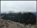
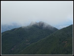
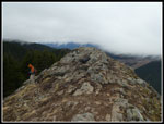
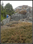
After the flat section is a climb up to the junction with the route over to Mt. Si. It is now signed with a nice trails map. I headed right and continued climbing. The route now turns and starts heading towards Mt. Teneriffe. Parts of this road were a clear cut 25 years ago. Big views out. Now the trees have grown back and the views are gone. The route flattens again before a short descent then the final climb up to the pass where the old road ends. I looked but there are no signs of the old cabin just above the road. I arrived at the pass and headed back into forest. The old boot path went straight up to the ridge top then followed it. Now the trail makes a number of gentle switchbacks as it climbs to the ridge top. The trail then drops to another pass and contours around the summit of Teneriffe. At the far end it meets the trail coming up from Kamikaze Falls. The last bit is steeper then up the rock slabs to the top. As I contoured around the summit I could hear the wind blowing. The temperature had reached the mid 40s half way up. Now it was much colder
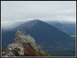
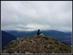
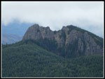
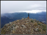
I reached the top at 10:46 am. The hike up was 6.5 miles with over 4000' of elevation gain. I took exactly 3:00 coming up. There was one person on the summit. Most of my visits have been when there is still snow at the 4788' summit. This day I did not see any snow on the entire route. The wind was blowing and my thermometer read 34 degrees. I put on a wind shirt on the ridge beyond the old road end. Now I pulled out a jacket as well. Clouds had continued to roll in. One moment I could see the top of Mailbox Peak then it was completely shrouded in white. Clouds blew by to elevations well below the summit. The cold wind made it hard to take gloves off to eat and photograph. Soon another hiker reached the top. Matt came up via the falls and planned to go down on the road/trail route.
I would have liked to spend more time on the summit but it was just too windy and cold. Matt went down first to have lunch out of the wind. The first hikers on top left soon after and one more hiker reached the top. It was not crowded but I was definitely not alone on the summit. I packed up and headed down at 11:15 am. I lasted almost half an hour on top. Down at the falls trail junction I met Matt once again. He had not been on the road route so I went on down with him. I had almost total solitude on the way up and had someone to talk hiking with on the way down. The Kamikaze Falls route is short but very steep. Our route down is long but never steep. Much easier on the knees. We met several people coming up as we descended but fewer than I expected.
With all the long road switchbacks the descent seems to go on and on but we made pretty good time. We took 2:24 to hike the 6.5 miles back to the car. We reached the trailhead at 2:00 pm. With all the ups and downs I hiked 13 miles with 4400' of elevation gain and loss. Quite a bit harder than the 15 mile level river walk I had first planned. This has been a poor hiking month during a very good hiking year. Life sometimes gets in the way. With that in mind I stopped at the High Point exit for a short hike around Tradition Lake. Starting at the gate and going almost to the Gas Line I added a very quick two additional miles with just a bit of elevation gain. That brought my day to 15 miles with 4500' of gain. This day added nearly 50% to the miles and elevation gain I managed during the first 22 days of the month. All in all it was a very nice day to hike up a mountain.
Click on thumbnails to get
larger pictures.
Trips - 2019
Home
This was my first time at the new parking lot and on the new half mile trail that connects with the old road. A nice trail and much softer tread than the old gravel road. Before reaching the junction I passed one hiker. Now back on the old road I continued on. Just after the signed junction for the falls I passed the second group of three hikers. The next mile is nearly flat as I sped up. I reached 1.5 miles in 30 minutes. The grade immediately begins to climb. After a short climb I stopped to replace a polypro layer and wool shirt with a light long sleeve shirt. It was now about 40 degrees and the consistent climbing kept me warm.
The road/trail conversion looks much better almost five years later. Much of the way has narrowed down to wide trail width. Not nearly as wide as it once was. It is still a bit rocky in places but seems pretty good overall. A group of five runner ran by. The last people I saw on the way up. Except, that is, for the same five runners running down. The route climbs until flattening out on a traverse away from Teneriffe. Just before the flat section there is a view to the south. Trees are starting to close it out but there is still a pretty good look out. Now the sky was totally white. Not a bit of blue sky was left. So much for the partly sunny forecast. I could see Rattlesnake Lake and Ridge though some lower clouds were moving in.
After the flat section is a climb up to the junction with the route over to Mt. Si. It is now signed with a nice trails map. I headed right and continued climbing. The route now turns and starts heading towards Mt. Teneriffe. Parts of this road were a clear cut 25 years ago. Big views out. Now the trees have grown back and the views are gone. The route flattens again before a short descent then the final climb up to the pass where the old road ends. I looked but there are no signs of the old cabin just above the road. I arrived at the pass and headed back into forest. The old boot path went straight up to the ridge top then followed it. Now the trail makes a number of gentle switchbacks as it climbs to the ridge top. The trail then drops to another pass and contours around the summit of Teneriffe. At the far end it meets the trail coming up from Kamikaze Falls. The last bit is steeper then up the rock slabs to the top. As I contoured around the summit I could hear the wind blowing. The temperature had reached the mid 40s half way up. Now it was much colder
I reached the top at 10:46 am. The hike up was 6.5 miles with over 4000' of elevation gain. I took exactly 3:00 coming up. There was one person on the summit. Most of my visits have been when there is still snow at the 4788' summit. This day I did not see any snow on the entire route. The wind was blowing and my thermometer read 34 degrees. I put on a wind shirt on the ridge beyond the old road end. Now I pulled out a jacket as well. Clouds had continued to roll in. One moment I could see the top of Mailbox Peak then it was completely shrouded in white. Clouds blew by to elevations well below the summit. The cold wind made it hard to take gloves off to eat and photograph. Soon another hiker reached the top. Matt came up via the falls and planned to go down on the road/trail route.
I would have liked to spend more time on the summit but it was just too windy and cold. Matt went down first to have lunch out of the wind. The first hikers on top left soon after and one more hiker reached the top. It was not crowded but I was definitely not alone on the summit. I packed up and headed down at 11:15 am. I lasted almost half an hour on top. Down at the falls trail junction I met Matt once again. He had not been on the road route so I went on down with him. I had almost total solitude on the way up and had someone to talk hiking with on the way down. The Kamikaze Falls route is short but very steep. Our route down is long but never steep. Much easier on the knees. We met several people coming up as we descended but fewer than I expected.
With all the long road switchbacks the descent seems to go on and on but we made pretty good time. We took 2:24 to hike the 6.5 miles back to the car. We reached the trailhead at 2:00 pm. With all the ups and downs I hiked 13 miles with 4400' of elevation gain and loss. Quite a bit harder than the 15 mile level river walk I had first planned. This has been a poor hiking month during a very good hiking year. Life sometimes gets in the way. With that in mind I stopped at the High Point exit for a short hike around Tradition Lake. Starting at the gate and going almost to the Gas Line I added a very quick two additional miles with just a bit of elevation gain. That brought my day to 15 miles with 4500' of gain. This day added nearly 50% to the miles and elevation gain I managed during the first 22 days of the month. All in all it was a very nice day to hike up a mountain.
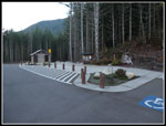 Trailhead |
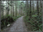 On The Old Road |
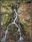 Waterfall |
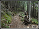 Climbing Begins |
 First View Out |
 Rocky Road |
 View Of Summit |
 Silver Trees |
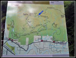 Map At Si Junction |
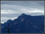 McClellan Butte |
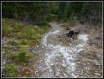 Icy Trail |
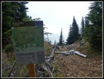 Map At Saddle |
 Trail To Ridge Top |
 On The Ridge Top |
 View Below Summit |
 Mailbox Peak |
 Summit Just Above |
 Lone Summit Hiker |
 Clouds Blow By |
 Rattlesnake Lake & Ridge |
 Cloudy Mt. Si |
 Hiker Heading Down |
 New Clear Cut |
 Clear Si Haystack |
 New Lone Hiker |
 Matt Heading Down |
 Momentary Sunshine |
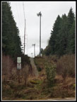 Cell Towers |
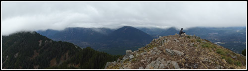 Summit Panorama Looking Northeast |
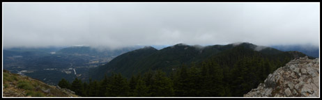 Panorama Looking Southeast. |
Trips - 2019
Home