1-25-20
Another
rainy weekend was on tap. 90% chance of rain. What to do? How about
another close in hike, this time on Cougar Mountain. I waited until the
rain slowed a bit and headed out at 8:42 am. It was a wet drive and I
arrived at the Red Town Trailhead at 9:15 am. The lot was only about
65% full. I was on my way by 9:21 am. I headed up the road with just a
few drops dripping down. A left on the Cave Hole Road and straight at
the Coal Creek Falls junction. I met two guys heading back. At the next
junction I turned right heading for Fred's Railroad. At that junction I
met two folks who turned right. I headed left. Two more hikers on the
crossing of the Clay Pit Road. That was it for people up to Anti
Aircraft Peak. The fine was a bit muddy after all our recent rain but I
did fine with low cut hiking shoes. I stopped at the first covered
picnic shelter for a short break. Still no rain so far. It was not
acting like a 90% chance of rain.
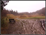
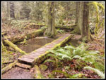
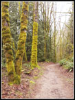
I headed back and and turned onto the trail to the Clay Pit. AA Lake was back. Not to it's largest size but it pretty much covered the entire trail. At the low point the trail crosses Tibbetts Creek. It was completely dry when I crossed in the fall. Now it was running pretty fast. At the junction with the trail to Cougar Pass I saw a hiker with a dog. Four human sightings in the first four miles on Cougar Mountain was not bad at all. Solitude within the city was fine with me. At the Clay Pit I had the expected view of Tiger Mountain and point to the east. None whatsoever.
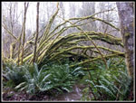
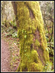
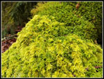
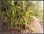
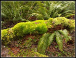
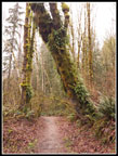
I started down the road and turned left onto the trail to Jerry's Duck Pond. Past the fenced mine shaft and up then down to the pond. It is very colorful with some type of green algae. The wet mist and white overcast really brought out the green mossy colors. The East Creek Trail down to Fred's Railroad was really mossy and colorful. At this point the colors were good enough that I started taking more photos. I seldom do a trip report for hikes on Cougar Mountain but the colors looked good enough for an exception. Lots of mossy arbors cross the trail and were especially colorful. There was a lot of water in the reeks that cross the trail and some muddy spots but I have seen this trail much worse on wet winter days. At Fred's Railroad I turned left. I had planned on a short umbrella hike but since the rain continued to hold off I decided to make it longer. I passed the Quarry Trail and continued on to Shy Bear Pass. The creek at the pass was quite wide and runny fast. It is dry most of the year.
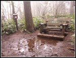
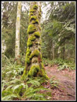
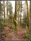
I turned left and headed up Wilderness Peak. Several groups were coming down as I went up. Perhaps it would not by crowded at the forested summit. I reached the top at 11:50 am. I had taken 2:29 to hike 6 miles. Wilderness Peak at 1598" is the highest point on Cougar Mountain. Two high points down and one to go. I dropped back down to Shy Bear Pass and went straight ahead on the trail to Long View Peak. It is .80 miles to the peak. I left the trail for the very short climb to the 1388" top of Long View Peak. When I first visited in about 1984 there was a long view. Now there are a lot of trees that have grown a lot in the intervening 36 years. I quickly turned around.
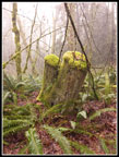
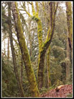
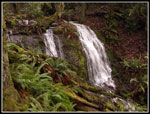
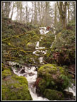
I was now on the Deceiver Ridge Trail. Along the top of the ridge then switchbacks down to the creek in the valley bottom. Lots of great colors here with mist all around and lots of wet hanging moss. I crossed the creek noticing how much more water than usually seen. I immediately reached the short spur trail down to a view of Doughty Falls. Most of the year the falls is a wide mossy slab with a trickle of water flowing down it. Not this day. There was quite a lot of water falling over the falls. it is not a big falls. but with all the bright white water it was pretty impressive. I stopped for photos and some video clips. This part of the park sees a lot less visitors. Now I climbed back up to the trail and continued uphill. At the top the trail is lined with a sea of salal. More good green color. The route then drops to the Shy Bear Trail.
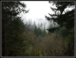
Now I had about .60 miles to go to reach Far Country Lookout. I finally saw a couple people along here. The trail drops then has a short climb to the top of Far Country Lookout. Back in the early 1980s the trail on the west side up to the lookout was a logging road straight up the fall line. There was a pretty good view. More than a decade or so later a switchbacking trail was built and a looping trail went to a new viewpoint below the old lookout spot. It still has a bit of a view but the growing trees have almost taken out the new viewpoint as well as the old one. Now Long View Peak has minimal views and so does Far Country Lookout. So far I had hiked 8.3 miles I had 2 miles still to go to reach the parking lot. I headed down the switchbacking trail on the west side to the Indian Trail. Rather than heading straight back I chose to turn left on the Indian Trail. It is pretty flat and did not take long to hike .30 miles. That extra little bit out and back brought me up to about 11 miles for the day.
Just after the trail up to Far Country Lookout is the short trail that drops to Far Country Falls. It is a trickle most of the year. The fact I could hear it well before reaching it attested to the elevated flow pouring over it. I hiked don to it and was not disappointed. none of the waterfalls at Cougar Mountain are tall but are worth visiting at high water. It looked good this day. Now I just had a trek along the Indian Trail and then the Wildside Trail back to the Ford Slope. I took a short detour there. The Ford Slope was the main coal mine shaft on the mountain. Railroad cars were lowered into the mine to deliver miners and take out coal. On my first visit in about 1983 the mine was open with signs warning of methane gas. now the shaft has been sealed. From there back to the parking lot took only a few minutes. I arrived at 2:20 pm. Almost exactly five hours after I started. I hiked 11 miles with 2000' of elevation gain. Not a bad gain considering the high point is only 1598'.
This was a fun hike. Though it was often misty I never pulled out my umbrella. A 90% chance of rain turned out to be a completely dry day. The mossy colors were the highlight of the day with the waterfalls running a close second. Cougar Mountain is not the Cascade Range but on what was supposed to be a wet winter day it proved to be a great outdoor experience. All than and not crowded at all.
Click on thumbnails to get
larger pictures.
Trips - 2020
Home
I headed back and and turned onto the trail to the Clay Pit. AA Lake was back. Not to it's largest size but it pretty much covered the entire trail. At the low point the trail crosses Tibbetts Creek. It was completely dry when I crossed in the fall. Now it was running pretty fast. At the junction with the trail to Cougar Pass I saw a hiker with a dog. Four human sightings in the first four miles on Cougar Mountain was not bad at all. Solitude within the city was fine with me. At the Clay Pit I had the expected view of Tiger Mountain and point to the east. None whatsoever.
I started down the road and turned left onto the trail to Jerry's Duck Pond. Past the fenced mine shaft and up then down to the pond. It is very colorful with some type of green algae. The wet mist and white overcast really brought out the green mossy colors. The East Creek Trail down to Fred's Railroad was really mossy and colorful. At this point the colors were good enough that I started taking more photos. I seldom do a trip report for hikes on Cougar Mountain but the colors looked good enough for an exception. Lots of mossy arbors cross the trail and were especially colorful. There was a lot of water in the reeks that cross the trail and some muddy spots but I have seen this trail much worse on wet winter days. At Fred's Railroad I turned left. I had planned on a short umbrella hike but since the rain continued to hold off I decided to make it longer. I passed the Quarry Trail and continued on to Shy Bear Pass. The creek at the pass was quite wide and runny fast. It is dry most of the year.
I turned left and headed up Wilderness Peak. Several groups were coming down as I went up. Perhaps it would not by crowded at the forested summit. I reached the top at 11:50 am. I had taken 2:29 to hike 6 miles. Wilderness Peak at 1598" is the highest point on Cougar Mountain. Two high points down and one to go. I dropped back down to Shy Bear Pass and went straight ahead on the trail to Long View Peak. It is .80 miles to the peak. I left the trail for the very short climb to the 1388" top of Long View Peak. When I first visited in about 1984 there was a long view. Now there are a lot of trees that have grown a lot in the intervening 36 years. I quickly turned around.
I was now on the Deceiver Ridge Trail. Along the top of the ridge then switchbacks down to the creek in the valley bottom. Lots of great colors here with mist all around and lots of wet hanging moss. I crossed the creek noticing how much more water than usually seen. I immediately reached the short spur trail down to a view of Doughty Falls. Most of the year the falls is a wide mossy slab with a trickle of water flowing down it. Not this day. There was quite a lot of water falling over the falls. it is not a big falls. but with all the bright white water it was pretty impressive. I stopped for photos and some video clips. This part of the park sees a lot less visitors. Now I climbed back up to the trail and continued uphill. At the top the trail is lined with a sea of salal. More good green color. The route then drops to the Shy Bear Trail.
Now I had about .60 miles to go to reach Far Country Lookout. I finally saw a couple people along here. The trail drops then has a short climb to the top of Far Country Lookout. Back in the early 1980s the trail on the west side up to the lookout was a logging road straight up the fall line. There was a pretty good view. More than a decade or so later a switchbacking trail was built and a looping trail went to a new viewpoint below the old lookout spot. It still has a bit of a view but the growing trees have almost taken out the new viewpoint as well as the old one. Now Long View Peak has minimal views and so does Far Country Lookout. So far I had hiked 8.3 miles I had 2 miles still to go to reach the parking lot. I headed down the switchbacking trail on the west side to the Indian Trail. Rather than heading straight back I chose to turn left on the Indian Trail. It is pretty flat and did not take long to hike .30 miles. That extra little bit out and back brought me up to about 11 miles for the day.
Just after the trail up to Far Country Lookout is the short trail that drops to Far Country Falls. It is a trickle most of the year. The fact I could hear it well before reaching it attested to the elevated flow pouring over it. I hiked don to it and was not disappointed. none of the waterfalls at Cougar Mountain are tall but are worth visiting at high water. It looked good this day. Now I just had a trek along the Indian Trail and then the Wildside Trail back to the Ford Slope. I took a short detour there. The Ford Slope was the main coal mine shaft on the mountain. Railroad cars were lowered into the mine to deliver miners and take out coal. On my first visit in about 1983 the mine was open with signs warning of methane gas. now the shaft has been sealed. From there back to the parking lot took only a few minutes. I arrived at 2:20 pm. Almost exactly five hours after I started. I hiked 11 miles with 2000' of elevation gain. Not a bad gain considering the high point is only 1598'.
This was a fun hike. Though it was often misty I never pulled out my umbrella. A 90% chance of rain turned out to be a completely dry day. The mossy colors were the highlight of the day with the waterfalls running a close second. Cougar Mountain is not the Cascade Range but on what was supposed to be a wet winter day it proved to be a great outdoor experience. All than and not crowded at all.
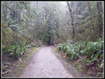 People Ahead |
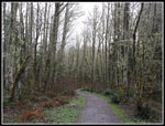 Leafless Trees |
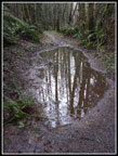 Anti Aircraft Lake |
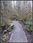 Tibbetts Creek Bridge |
 The Clay Pit |
 Mossy Branches |
 Wilderness Peak Summit |
 Mossy Stumps |
 Colorful Moss |
 Clumps Of Moss |
 Close Up Colors |
 More Moss |
 Hanging Moss |
 Descending Ridge |
 Mossy Bridge |
 Doughty Falls |
 Great Colors |
 Cloudy View |
 Even More Moss |
 Far Country Falls |
 Ferns On Tree |
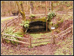 The Ford Slope |
Trips - 2020
Home