3-01-20
I
headed back to the Highway 18 side of Tiger Mountain for a second
weekend in a row. This time I was heading for the highest point on
Tiger Mountain. At 3004' East Tiger is the same elevation as Snoqualmie
Pass. I was expecting a lot less snow. Thursday nights
headlamp hike showed that there was snow above about 2500' on north
aspects. I left Seattle under blue sky. As I drove east it became a bit
white. As I neared Tiger Summit there was a little fresh snow. It was
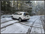
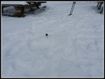
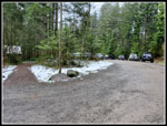
8:22 am and the lot by the highway was nearly empty. Only about half a
dozen cars to be seen. I headed to the inner lot and found it equally
empty. About half a dozen cars there. No people to be seen. The lot had
a thin coat of fresh snow. I packet up and was on my way by 8:30 am. It
was a balmy 33 degrees as I started out. This would be my first trip
with my new Samsung S10 cell phone camera. A lot has changed since I
bought my old S4. Six years for one.
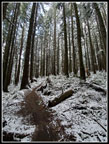
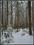
There were a few bike tracks in the fresh snow as I headed out on the Connector Trail. I quickly reached the main road and crossed onto the Northwest Timber Trail. Not far along I turned left on the Master Link Trail. This one way uphill bike trail is very gently graded. One way for bikes though hikers can go up or down. In a month or so the wildflowers will be out. For now it was mostly dirt. It was warm enough that snow was melting from the trees and falling on me. As I climbed the trail had some snow again. The thick tree cover blocked it lower down. I kept waiting for the first biker to catch up and pass me. I waited a long time. The conditions were good for trying out the new camera. A little sunshine and then overcast. The white balance was excellent. I will not be making many changes to the photos I post.
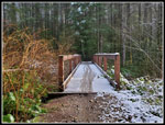
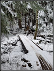
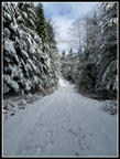
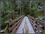
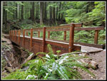
By the time I reached the Inside Passage Trail junction the snow completely covered the trail. It did start to feel warmer. Partly the heat generated by climbing and partly just plain warner. There was snow on the big bridge and a couple tire tracks. The flocked trees were very photogenic. I continued to climb until I reached the road crossing at the top of the Master Link. There were no tracks going up or down the road. I followed tracks across the road and onto the Quick Link Trail. In no time I reached the road once again. The last mile or so is on road to the top of East Tiger Mountain.
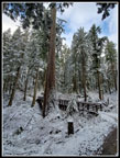
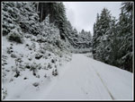
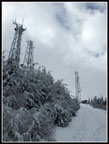
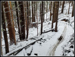
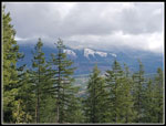
I expected more snow on the road. It was just 3-4 inches deep. There were a couple tire tracks and two boot tracks. Still no people. When I passed the start of the black diamond Predator Trail I saw a track heading up it. I can't imagine doing it in snow. The trail dropped to the next junction. I headed right for the last .70 miles to the summit. I picked up more boot tracks here. It seems the road was more popular than my route up. I turned left to the viewpoint and there was no view. It was now just to cloudy. Back to the road and up I went. At the point the East Tiger Trail crossed the road I saw tracks on the trail. I continued up the road soon reaching the top. The summit was in clouds. I could see the towers but not much looking out. There was a little blue hole in the clouds.
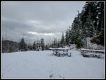
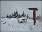
The picnic tables had 6 or so inches of snow. That was the deepest snow I saw all day. A little at the 1400' trailhead and still only half a foot at 3000'. Plenty of snow to flock the trees but not enough to impede travel. I reached the top at 10:30 am. Four miles in two hours was not a good time but with lots of photos and the snow it was understandable. I only spent ten minutes on top and headed down. Before leaving I saw a small vole or mouse that headed straight for me. A two ounce rodent was chasing me. It was strange. Starting down I stopped to open Gaia gps and recorded a track of my descent. I quickly reached where the East Tiger Trail crosses the road. I had been debating returning the way I came up or making a longer loop via the Off The Grid (OTG) and Northwest Timber Trails. I decided to take the longer route. The OTG leaves the East Tiger Trail quickly. Some of the footprints were on each trail. I would have a track to follow in the snow.
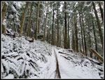
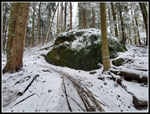
There was enough snow to make for a winter wonderland. Again, it did not snow me down much at all. I passed the Drop In Trail and a bike finally passed me. I had hiked five miles before I saw a single person. That is amazing solitude on a weekend. The route mostly follows below the road. It is longer as it switches back occasionally. On the short section where I was below the Quick Link I saw two hikers above. I made good time on the descent. The trail finally crosses the road about 2.5 miles down from the summit. The snow was beginning to thin at this elevation. I continued down. As the snow thinned it became muddy. There were also a number of mud puddles. It was easy enough to get around them. At the Silent Swamp Trail junction I saw two bikers. They passed me and were quickly out of sight.
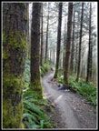
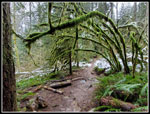
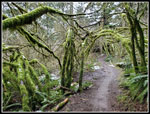
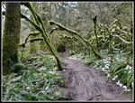
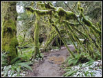
There are lots of bridges on the way back. The creeks are mostly seasonal and all were running this time of year. It takes a long time to reach the Northwest Timber Trail. I was glad to finally see it. Now it was a mostly straight shot back to the car. The trail has ups and downs but does not change much elevation. The nearer I came to the end the more folks I saw. Still not many but after seeing almost nobody the first three hours it seemed busier. This forest has some very nice sections of hanging moss and mossy arbors overhanging the trail. More things to photograph. I was glad to reach the Master Link and complete the loop. Now it was just about .40 miles back to the trailhead. The low snow had mostly melted. Very little snow was left. I reached the mostly filled parking lot at 1:07 pm. Still pretty early in the day. I hiked 4 mies up in 2 hours and 6 miles down in 2:27.
This is a close in hike on bike trails and roads. It is best in the winter. The snow turned roads into open snowy pathways. The trees were flocked with white. There were no bike tracks at all at the summit. I had more solitude than expected. Mt. Si likely had its 500+ hikers this day and I did not see 15 people over ten miles. I was impressed with the camera's ability to handle the bright and dark lighting and to get the white snow correctly. All in all, a great day on the trail.
Click on thumbnails to get
larger pictures.
Trips - 2020
Home
There were a few bike tracks in the fresh snow as I headed out on the Connector Trail. I quickly reached the main road and crossed onto the Northwest Timber Trail. Not far along I turned left on the Master Link Trail. This one way uphill bike trail is very gently graded. One way for bikes though hikers can go up or down. In a month or so the wildflowers will be out. For now it was mostly dirt. It was warm enough that snow was melting from the trees and falling on me. As I climbed the trail had some snow again. The thick tree cover blocked it lower down. I kept waiting for the first biker to catch up and pass me. I waited a long time. The conditions were good for trying out the new camera. A little sunshine and then overcast. The white balance was excellent. I will not be making many changes to the photos I post.
By the time I reached the Inside Passage Trail junction the snow completely covered the trail. It did start to feel warmer. Partly the heat generated by climbing and partly just plain warner. There was snow on the big bridge and a couple tire tracks. The flocked trees were very photogenic. I continued to climb until I reached the road crossing at the top of the Master Link. There were no tracks going up or down the road. I followed tracks across the road and onto the Quick Link Trail. In no time I reached the road once again. The last mile or so is on road to the top of East Tiger Mountain.
I expected more snow on the road. It was just 3-4 inches deep. There were a couple tire tracks and two boot tracks. Still no people. When I passed the start of the black diamond Predator Trail I saw a track heading up it. I can't imagine doing it in snow. The trail dropped to the next junction. I headed right for the last .70 miles to the summit. I picked up more boot tracks here. It seems the road was more popular than my route up. I turned left to the viewpoint and there was no view. It was now just to cloudy. Back to the road and up I went. At the point the East Tiger Trail crossed the road I saw tracks on the trail. I continued up the road soon reaching the top. The summit was in clouds. I could see the towers but not much looking out. There was a little blue hole in the clouds.
The picnic tables had 6 or so inches of snow. That was the deepest snow I saw all day. A little at the 1400' trailhead and still only half a foot at 3000'. Plenty of snow to flock the trees but not enough to impede travel. I reached the top at 10:30 am. Four miles in two hours was not a good time but with lots of photos and the snow it was understandable. I only spent ten minutes on top and headed down. Before leaving I saw a small vole or mouse that headed straight for me. A two ounce rodent was chasing me. It was strange. Starting down I stopped to open Gaia gps and recorded a track of my descent. I quickly reached where the East Tiger Trail crosses the road. I had been debating returning the way I came up or making a longer loop via the Off The Grid (OTG) and Northwest Timber Trails. I decided to take the longer route. The OTG leaves the East Tiger Trail quickly. Some of the footprints were on each trail. I would have a track to follow in the snow.
There was enough snow to make for a winter wonderland. Again, it did not snow me down much at all. I passed the Drop In Trail and a bike finally passed me. I had hiked five miles before I saw a single person. That is amazing solitude on a weekend. The route mostly follows below the road. It is longer as it switches back occasionally. On the short section where I was below the Quick Link I saw two hikers above. I made good time on the descent. The trail finally crosses the road about 2.5 miles down from the summit. The snow was beginning to thin at this elevation. I continued down. As the snow thinned it became muddy. There were also a number of mud puddles. It was easy enough to get around them. At the Silent Swamp Trail junction I saw two bikers. They passed me and were quickly out of sight.
There are lots of bridges on the way back. The creeks are mostly seasonal and all were running this time of year. It takes a long time to reach the Northwest Timber Trail. I was glad to finally see it. Now it was a mostly straight shot back to the car. The trail has ups and downs but does not change much elevation. The nearer I came to the end the more folks I saw. Still not many but after seeing almost nobody the first three hours it seemed busier. This forest has some very nice sections of hanging moss and mossy arbors overhanging the trail. More things to photograph. I was glad to reach the Master Link and complete the loop. Now it was just about .40 miles back to the trailhead. The low snow had mostly melted. Very little snow was left. I reached the mostly filled parking lot at 1:07 pm. Still pretty early in the day. I hiked 4 mies up in 2 hours and 6 miles down in 2:27.
This is a close in hike on bike trails and roads. It is best in the winter. The snow turned roads into open snowy pathways. The trees were flocked with white. There were no bike tracks at all at the summit. I had more solitude than expected. Mt. Si likely had its 500+ hikers this day and I did not see 15 people over ten miles. I was impressed with the camera's ability to handle the bright and dark lighting and to get the white snow correctly. All in all, a great day on the trail.
 Snow In Parking Lot |
 A Little Sunshine |
 Bare Ground |
 A Shadow! |
 Snow Along The Trail |
 Big Tree & Bridge |
 Sliver Of Brown Traill |
 Big Green Rock |
 Snowy Bridge |
 Top Of Master Link |
 Snowy Branches |
 On The Road |
 Snowy Viewpoint |
 More Footprints |
 Nearing Summit |
 Summit Picnic Tables |
 Fearless Vole |
 Heading Down |
 Switchback |
 Road Crossing |
 Passed By Bikers |
 Mossy Arbor |
 Wheel On A Snag |
 Shelf Fungi |
 View Of Rattlesnake Mt |
 Another Bridge |
 Mossy Rainforest |
 Very Green |
 Another Arbor |
 Lot Is Nearly Full |
Trips - 2020
Home