1-12-20
Last
weekend I tried to hike up East Tiger Mountain via the Master Link and
Quick Link Trails. 2.7 miles up I realized I had forgotten to put up my
Discover Pass. I hurried down, put up my pass, and hiked 2.3 miles up
the road. A 10 mile day but no summit. This day it would be windy with
some precipitation. Avalanche danger was high in the mountains. In
fact, Snoqualmie Pass was closed much of the day. I needed to go where
the wind would be largely blocked and the start high enough to get out
of rain and into falling snow as quickly as possible. How about East
Tiger Mountain? Actually the forecast was so poor that I planned to
stay home. The radar was showing the entire route up East Tiger to be
in snow. I decided to go for it after all. I now had a later than
normal starting time. Seattle was in a donut hole. While it was raining
or snowing over most of the area it was a dry drive as far as Preston.
Lots of water on the road being thrown up on my windshield but none
falling from the sky. I turned off onto Highway 18 and a few minutes
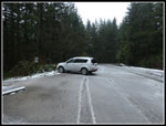
later arrived at Tiger Summit. By 9:00 am most weekend days the outer
lot is mostly full. Not this day. There were only four or so cards in
the lot. It was lightly sleeting. I drove to the inner lot and found
only a few cars there. There was just a little wet snow in the lot. I
arrived at 9:10 am. Five minutes later I was on my way.
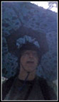
For my birthday Suzanne gave me a fold up umbrella that straps to your head. Kind of a crazy idea but handy if my hands would be free to hold hiking poles. With nobody around to see, I strapped in on. There was a bit of wind at the start but not enough to cause an umbrella problem. Umbrella now locked to my head I started up the trail. The short Connector Trail was as wet as I have ever seen it. I had on my high top boots with a fresh layer of snow seal and just plowed through the big puddles. I quickly reached the main road and crossed onto the Northwest Timber Trail. Just a few minutes up that I turned onto the Master Link Trail. The next 2.5 miles were on this one way uphill bide trail. Hikers can go in both directions.
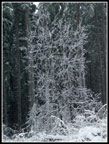
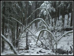
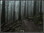
The Master Link is very gently graded for bikes. It hikes very fast. There was a little mud but not much. The question is usually how far up I can get before the first bike passes me. Not this day. Total solitude on the Master and Quick Link Trails. I could here high winds at times but the trees aboves me were not swaying. When the wind is high enough for big branches to start flying I turn around. That was not happening and there were almost no branches on the trail. There were three small trees down in one spot and I was just able to get them off the trail. If they were any heavier I would not have been able to move them. There was no snow on the trail until just over a mile from the trailhead. The sleet/rain let up too. At about 1.5 miles I stopped to take off my umbrella. It actually worked.
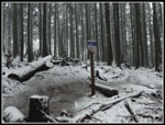
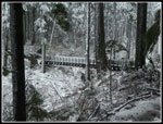
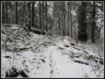
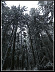
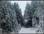
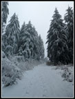
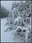
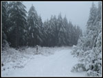
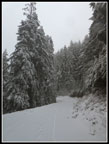
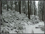
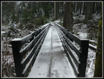
By the time I reached the Inside Passage Trail the ground was mostly snow covered. Still not much. The big bridge is in the open and had more snow on it. Back in the forest the snow reverted to a thin cover. While the ground still had some dirt showing the trees were now nicely flocked. When the ground was fully covered it really was a great winter scene. A great scene but still very easy to hike in. I reached the road at the top of the Master Link at 10:52 am. I took 1:37 vs the 56 minutes the week before. I did take a lot of photos but the snow definitely slowed my pace. That and heavier boot and backpack. When the snow covered the trail I could see that one person and one dog were ahead of me. I expected to see more tracks. Also no bike tracks at all. At the top of the Quick Link the snow was much deeper on the road. I stopped to put on gaiters. it still was not that deep but about 4" to 5' vis just a few in the forest.The trees along the road were really snow plastered. It really looked like mid winter now.
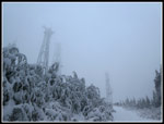
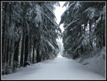
The road climbs then drops to the junction with the East Tiger summit spur road. It was at that junction I met a guy and a dog. The first people of the day. They were heading down via the road. We talked for a few minutes They did not come up my route. There were several more tracks that had gone up and down the road. I would have more tracks to follow the last .70 miles to the top. The other guy did mention tow vehicles that had dried the road until they were stuck. With my route up and down I did not see that. The summit spur has some steep spots. As I ascended the snow became a bit deeper. The tracks were sinking abut 4" to 6". It had been snowing for awhile on the road but stopped before I reached the top. The route goes up from the east and the wind was out of the southwest. A major reason I chose this trail. At the 3004' summit I expected to get all of the 20 mph with gusts to 30 mph. It did not happen. There was some wind on top but nothing close to what I expected. I reached the 3004' summit at 11:22 am.
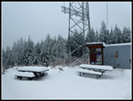
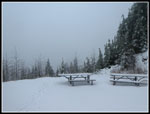
The temperature at the start had been 35 degrees. At the summit it was 31 degrees. Cold but with a light wind it was not terrible. The picnic tables had a lot of snow on them. Snow depth on the ground was about 6" to 8 i". Snoqualmie Pass is exactly the same elevation and it had six times as much snow. I benefited by being on the one so much closer the warm salt water. No snowshoes needed this day. I stayed on top for no more than ten minutes then started down. I had been warm coming up but I quickly cooled down on the descent. I was still undecided on my descent route. I took a short detour to the viewpoint. A cold wind and zero views as expected. At the road junction I considered taking the road back for a loop trip. There was a strong wind blowing up the road. I quickly decided the forest route I took up was a better and safer choice.
When I reached the start of the steepest bike trail, Predator, I saw tracks coming up the road and onto that trail. It seemed crazy to bike down it in snow. Someone did it. The two bike tracks came up my route after me. I made quick work of the road and Quick Link the hiked a mile down the Master Link before meeting the second group of the day. That was a lot of solitude on East Tiger Mountain. With about a mile to go I started meeting more folks hiking up. Two hikers, two adult men with two boys, and a sole hiker. Not many in total and all fairly close together. I reached the trailhead at 1:12 pm. 3:57 is a very slow time but okay under these conditions. I hiked 8 miles with 1700' of elevation gain. There were a dozen or so cars in the lot. A very low number for any weekend of the year.
This was a really fun hike. I had an opportunity to try out my new "umbrella hat", reached the summit that eluded me the week before, had amazing solitude, and the winter scenery was outstanding. It will be a long time before I hike out of Tiger Summit two weeks in a row but I had fun on both hikes. The drive home was easy and later that day the Seahawks lost a close game that put Green Bay in the NFC Championship Game.
Click on thumbnails to get
larger pictures.
Trips - 2020
Home
For my birthday Suzanne gave me a fold up umbrella that straps to your head. Kind of a crazy idea but handy if my hands would be free to hold hiking poles. With nobody around to see, I strapped in on. There was a bit of wind at the start but not enough to cause an umbrella problem. Umbrella now locked to my head I started up the trail. The short Connector Trail was as wet as I have ever seen it. I had on my high top boots with a fresh layer of snow seal and just plowed through the big puddles. I quickly reached the main road and crossed onto the Northwest Timber Trail. Just a few minutes up that I turned onto the Master Link Trail. The next 2.5 miles were on this one way uphill bide trail. Hikers can go in both directions.
The Master Link is very gently graded for bikes. It hikes very fast. There was a little mud but not much. The question is usually how far up I can get before the first bike passes me. Not this day. Total solitude on the Master and Quick Link Trails. I could here high winds at times but the trees aboves me were not swaying. When the wind is high enough for big branches to start flying I turn around. That was not happening and there were almost no branches on the trail. There were three small trees down in one spot and I was just able to get them off the trail. If they were any heavier I would not have been able to move them. There was no snow on the trail until just over a mile from the trailhead. The sleet/rain let up too. At about 1.5 miles I stopped to take off my umbrella. It actually worked.
By the time I reached the Inside Passage Trail the ground was mostly snow covered. Still not much. The big bridge is in the open and had more snow on it. Back in the forest the snow reverted to a thin cover. While the ground still had some dirt showing the trees were now nicely flocked. When the ground was fully covered it really was a great winter scene. A great scene but still very easy to hike in. I reached the road at the top of the Master Link at 10:52 am. I took 1:37 vs the 56 minutes the week before. I did take a lot of photos but the snow definitely slowed my pace. That and heavier boot and backpack. When the snow covered the trail I could see that one person and one dog were ahead of me. I expected to see more tracks. Also no bike tracks at all. At the top of the Quick Link the snow was much deeper on the road. I stopped to put on gaiters. it still was not that deep but about 4" to 5' vis just a few in the forest.The trees along the road were really snow plastered. It really looked like mid winter now.
The road climbs then drops to the junction with the East Tiger summit spur road. It was at that junction I met a guy and a dog. The first people of the day. They were heading down via the road. We talked for a few minutes They did not come up my route. There were several more tracks that had gone up and down the road. I would have more tracks to follow the last .70 miles to the top. The other guy did mention tow vehicles that had dried the road until they were stuck. With my route up and down I did not see that. The summit spur has some steep spots. As I ascended the snow became a bit deeper. The tracks were sinking abut 4" to 6". It had been snowing for awhile on the road but stopped before I reached the top. The route goes up from the east and the wind was out of the southwest. A major reason I chose this trail. At the 3004' summit I expected to get all of the 20 mph with gusts to 30 mph. It did not happen. There was some wind on top but nothing close to what I expected. I reached the 3004' summit at 11:22 am.
The temperature at the start had been 35 degrees. At the summit it was 31 degrees. Cold but with a light wind it was not terrible. The picnic tables had a lot of snow on them. Snow depth on the ground was about 6" to 8 i". Snoqualmie Pass is exactly the same elevation and it had six times as much snow. I benefited by being on the one so much closer the warm salt water. No snowshoes needed this day. I stayed on top for no more than ten minutes then started down. I had been warm coming up but I quickly cooled down on the descent. I was still undecided on my descent route. I took a short detour to the viewpoint. A cold wind and zero views as expected. At the road junction I considered taking the road back for a loop trip. There was a strong wind blowing up the road. I quickly decided the forest route I took up was a better and safer choice.
When I reached the start of the steepest bike trail, Predator, I saw tracks coming up the road and onto that trail. It seemed crazy to bike down it in snow. Someone did it. The two bike tracks came up my route after me. I made quick work of the road and Quick Link the hiked a mile down the Master Link before meeting the second group of the day. That was a lot of solitude on East Tiger Mountain. With about a mile to go I started meeting more folks hiking up. Two hikers, two adult men with two boys, and a sole hiker. Not many in total and all fairly close together. I reached the trailhead at 1:12 pm. 3:57 is a very slow time but okay under these conditions. I hiked 8 miles with 1700' of elevation gain. There were a dozen or so cars in the lot. A very low number for any weekend of the year.
This was a really fun hike. I had an opportunity to try out my new "umbrella hat", reached the summit that eluded me the week before, had amazing solitude, and the winter scenery was outstanding. It will be a long time before I hike out of Tiger Summit two weeks in a row but I had fun on both hikes. The drive home was easy and later that day the Seahawks lost a close game that put Green Bay in the NFC Championship Game.
 Empty Parking Lot |
 Umbrella Head |
 Cascading Creek |
 Dusting Of Snow |
 Inside Passage Trail |
 The Big Bridge |
 Footprints |
 Looking Up |
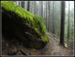
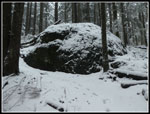 Big Snowy Rock |
 White Stripes |
 A Little Deeper |
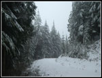 On The Road Again |
 Very Scenic |
 Nearing The Summit |
 Towers In Sight |
 Snowy Picnic Tables |
 Snow Sculptures |
 All Lit Up |
 Trail Crossing |
 Cathedral Roof |
 Viewpoint? |
 Bike Tracks |
 Snowy Arches |
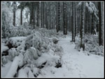
 Snowy Brush |
 Less Snowy Bridge |
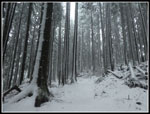
 Dark Forest |
 Some Actual Color |
 Best Color |
Trips - 2020
Home