6-19-20
The
weekend forecast was for rain. Friday would be sunny and warm. I
decided to take off Friday and Gary and John also were able to go for a
hike. We wanted a trip with few other people, some wildflowers, and
views. I suggested a few and Gary recommended a trip up to Medra Pass
and then along the ridge to Koppen Mountain. It looked to be in the
high 70s in Cle Elum and cooler at higher elevations in the Teanaway
Valley. We met at the trailhead for the Johnson Creek Trail along the
NF Teanaway Road. Much to my surprise two other hikers headed out just
before us. We were on our way by 8:30 am. It was warm enough already
that I changed into a short sleeve shirt.
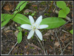
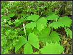
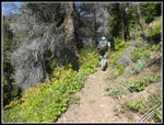
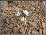
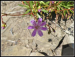
We crossed the river on a bridge and headed up the valley. It is 3.5 miles to Medra Pass with about 2400' of gain. It is very much back end loaded. The route gains minimal elevation in the first half. I was pleased to see queen's cup, columbine, and vanilla leaf in bloom from near the start. The flower show continued most all the way. This is not known as a wildflower hike but the display in June is very good. Although we were climbing up the north side of the ridge to the 5400' pass there was only one small patch of snow near the pass and it was off trail at a switchback. There are some small ups and downs along the creek. Just past .50 miles we reached the Jungle Creek Trail junction. The old signs are here but with new sign posts. We made steady progress with some photo stops. Since we had all day we had plenty of time to stop for photos.
There are two crossings of the creek. My old 100 Hikes book mentions four crossings. My memory would agree with that. CalTopo online maps snows six crossings. Gary's trip report from 2018 mentions four crossings. There are definitely only two crossings now. One time across and then back. Coming down we noticed a lot of recent trail work. Along with removing a est of creek crossings trail has either been created or improved in a number of spots on the lower half of the trail. It is now fa bit away from and above the creek and so less brushy. It should be easier to keep it brushed out now too.
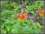
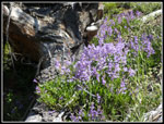
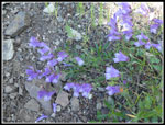
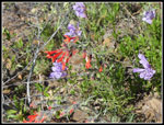
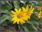
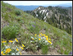
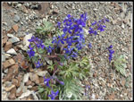
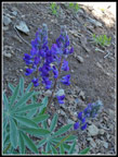
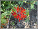
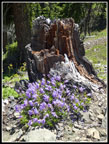
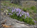
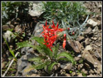
The creek crossings were easy enough to rock hop across. At long last the grade began to steepen. As it climbed we moved out of the forest. The open slopes began to be covered in wildflowers. Bluish penstemon grows in profusion. Their is also red and orange Indian paintbrush in bloom. Add in a little scarlet gilia and some big patches of silver crown. We also saw a lot of blooming Columbia Lewisia. These continued much of the way to the summit. I seldom see it and this was a very large display. Lots of bright colors along the trail. Part way up the open slopes we caught the two women hikers. They represented half the people we met on the trail until the last mile coming down.. I zipped off my pants legs when the climbing began. It was getting quite warm though it was still morning.
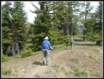
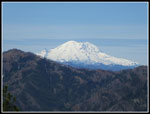
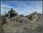
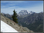
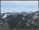
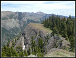
When the trail reached the top of the side ridge we had views out towards the top of Mt. Stuart and some other Teanaway peaks. After a steep climb along the ridge top the trail headed left for Medra Pass. This is a horse and motorcycle trail and the trail takes a few gentle switchbacks to reach Medra Pass. At the pass was a climber who was out on a motorcycle this day. We had a brief conversation with him before continuing on. The next 1.7 miles is on an old sheep highway. Domestic sheep used to graze along the ridge top. Their path is long gone but a minimal trail still exists. I mentioned to the guys that on previous trips I have taken a wrong turn and started down a wrong ridge. The warning was not enough to keep us from doing it again. Heading north from the pass we reached an open spot with a great view of Mt. Rainier. It was sunlit and there was no haze. We continued on and the route spit. An obvious trail heading across the slope at a gentle grade and a lesser route heading straight up. We took the lower route. It brought us out to a nob with some excellent views and more wildflowers. Balsamroot was blooming along with douglasia and onions.
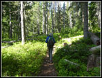
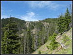
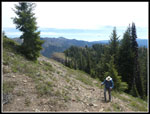
We took a break. Food, water, and lots of sunscreen. As we were leaving the two women caught up. We head them behind us for a while but did not see them again. Having ended up on this nob several times before I headed right up the ridge and intersected the correct trail. Now back on the correct ridge we had no more problems. The ridge walk is either on top or below on the left side. We periodically had views out in all directions. Thankfully there was some occasional shade as it was getting much warmer. Thanks to the coronavirus pandemic I have not been getting out to high summits this year. So far, 3680' was the highest elevation any of us had reached. By now I usually have been up a few Teanaway 7000' peaks. I had also only managed two 3000' gain hikes. The elevation, heat, and rough steep ridge route made this more difficult than it it would have been most any other year.
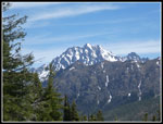
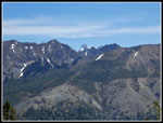
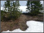
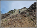
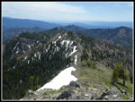
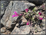
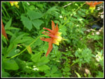
We saw a number of really colorful reddish penstemon. Also just a couple glacier lilies still in bloom. At one spot a tilted plateau was covered with balsamroot and a little lupine. Beyond is Mt. Stuart. I always stop for photos here. We did in both coming and going. From there the route makes a steep climb up Point 5800. At the top there is still a good sized snow bank. We were able to go right around it. We brought high top boot but snow was never a problem. We descended to the last problem before reaching Koppen Mountain. The route crosses a rocky and grassy slope below the ridge top. We lost the route and went too high. We had to drop down and found the very vague and minimal trail. I have done this trip in 1993, 2002, 2009, and 2112. This was the sketchiest I have seen the route across here. Once back on track we had no trouble getting to the last saddle before Koppen.
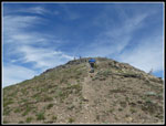
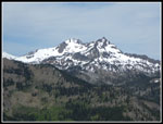
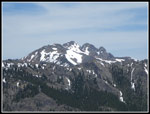
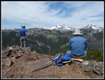
There is or was a trail through steep grass to the summit. We lost it and headed straight up. This was not as easy as it appeared. It turned to a rock scramble just below the top. We had seen three folks on top from The bottom and one person part way up. We arrived on top to find it empty. Great views in all directions. The peaks of the Cascade Crest were in the clear. Closer were Hawkins, Esmerelda, Fortune, Ingalls, Stuart, the Stuart Range and many Teanaway Peaks. Iron Peak is right across the valley. To the south Rainier was still clear and we could see the top of Mt. Adams. We arrived at 12:08 pm. Not a fast pace but we had a few breaks and took a lot of photos. We spent about an hour on top. Another hiker came up from the DeRoux side just before we left. At 1:05 pm we headed down.
We followed the trail as it traversed right then switchbacked below the rock section we scrambled up. As we headed down tot he saddle the trail disappeared. A section of it has washed away. We had to sidehill across to pick up the route again. That explained how we lost it on the way up. We had a much easier time crossing the sketchy section now that we knew where it was. Back up and over Point 5800 and down again. The ridge walking was a highlight of the day. We arrived back at Medra Pass at 2:14 pm. Time for one more break before the descent. By now it was getting very warm. Much warmer than the forecast. The descent though the open sections was not that pleasant. I did stop for more photos but far few than on the ascent. I was glad to finally reach the forest. Even much of that was hot as the higher sun shone down where it was shady in the morning. In the last mile we passed two bikers and two hikers coming in.
We reached the trailhead at 4:14 pm. It was 79 degrees. This was a great trip. We successfully avoided crowds. We had a long ridge walk, We had a 6,000' summit to ourselves for almost an hour. The route had a little scrambling and we added a new one right near the top. The wildflower display was very good. Not the profusion of some spots but we saw quite a variety in bloom. The drive home might have been more difficult than the hike. An accident had I-90 backed up 8 miles. I took one hour to go 1.2 miles. Much sower than our hiking speed. Instead of a two hour drive home it was 3:45. Still, it was well worth it to get in a great hike.
Click on thumbnails to get
larger pictures.
Trips - 2020
Home
We crossed the river on a bridge and headed up the valley. It is 3.5 miles to Medra Pass with about 2400' of gain. It is very much back end loaded. The route gains minimal elevation in the first half. I was pleased to see queen's cup, columbine, and vanilla leaf in bloom from near the start. The flower show continued most all the way. This is not known as a wildflower hike but the display in June is very good. Although we were climbing up the north side of the ridge to the 5400' pass there was only one small patch of snow near the pass and it was off trail at a switchback. There are some small ups and downs along the creek. Just past .50 miles we reached the Jungle Creek Trail junction. The old signs are here but with new sign posts. We made steady progress with some photo stops. Since we had all day we had plenty of time to stop for photos.
There are two crossings of the creek. My old 100 Hikes book mentions four crossings. My memory would agree with that. CalTopo online maps snows six crossings. Gary's trip report from 2018 mentions four crossings. There are definitely only two crossings now. One time across and then back. Coming down we noticed a lot of recent trail work. Along with removing a est of creek crossings trail has either been created or improved in a number of spots on the lower half of the trail. It is now fa bit away from and above the creek and so less brushy. It should be easier to keep it brushed out now too.
The creek crossings were easy enough to rock hop across. At long last the grade began to steepen. As it climbed we moved out of the forest. The open slopes began to be covered in wildflowers. Bluish penstemon grows in profusion. Their is also red and orange Indian paintbrush in bloom. Add in a little scarlet gilia and some big patches of silver crown. We also saw a lot of blooming Columbia Lewisia. These continued much of the way to the summit. I seldom see it and this was a very large display. Lots of bright colors along the trail. Part way up the open slopes we caught the two women hikers. They represented half the people we met on the trail until the last mile coming down.. I zipped off my pants legs when the climbing began. It was getting quite warm though it was still morning.
When the trail reached the top of the side ridge we had views out towards the top of Mt. Stuart and some other Teanaway peaks. After a steep climb along the ridge top the trail headed left for Medra Pass. This is a horse and motorcycle trail and the trail takes a few gentle switchbacks to reach Medra Pass. At the pass was a climber who was out on a motorcycle this day. We had a brief conversation with him before continuing on. The next 1.7 miles is on an old sheep highway. Domestic sheep used to graze along the ridge top. Their path is long gone but a minimal trail still exists. I mentioned to the guys that on previous trips I have taken a wrong turn and started down a wrong ridge. The warning was not enough to keep us from doing it again. Heading north from the pass we reached an open spot with a great view of Mt. Rainier. It was sunlit and there was no haze. We continued on and the route spit. An obvious trail heading across the slope at a gentle grade and a lesser route heading straight up. We took the lower route. It brought us out to a nob with some excellent views and more wildflowers. Balsamroot was blooming along with douglasia and onions.
We took a break. Food, water, and lots of sunscreen. As we were leaving the two women caught up. We head them behind us for a while but did not see them again. Having ended up on this nob several times before I headed right up the ridge and intersected the correct trail. Now back on the correct ridge we had no more problems. The ridge walk is either on top or below on the left side. We periodically had views out in all directions. Thankfully there was some occasional shade as it was getting much warmer. Thanks to the coronavirus pandemic I have not been getting out to high summits this year. So far, 3680' was the highest elevation any of us had reached. By now I usually have been up a few Teanaway 7000' peaks. I had also only managed two 3000' gain hikes. The elevation, heat, and rough steep ridge route made this more difficult than it it would have been most any other year.
We saw a number of really colorful reddish penstemon. Also just a couple glacier lilies still in bloom. At one spot a tilted plateau was covered with balsamroot and a little lupine. Beyond is Mt. Stuart. I always stop for photos here. We did in both coming and going. From there the route makes a steep climb up Point 5800. At the top there is still a good sized snow bank. We were able to go right around it. We brought high top boot but snow was never a problem. We descended to the last problem before reaching Koppen Mountain. The route crosses a rocky and grassy slope below the ridge top. We lost the route and went too high. We had to drop down and found the very vague and minimal trail. I have done this trip in 1993, 2002, 2009, and 2112. This was the sketchiest I have seen the route across here. Once back on track we had no trouble getting to the last saddle before Koppen.
There is or was a trail through steep grass to the summit. We lost it and headed straight up. This was not as easy as it appeared. It turned to a rock scramble just below the top. We had seen three folks on top from The bottom and one person part way up. We arrived on top to find it empty. Great views in all directions. The peaks of the Cascade Crest were in the clear. Closer were Hawkins, Esmerelda, Fortune, Ingalls, Stuart, the Stuart Range and many Teanaway Peaks. Iron Peak is right across the valley. To the south Rainier was still clear and we could see the top of Mt. Adams. We arrived at 12:08 pm. Not a fast pace but we had a few breaks and took a lot of photos. We spent about an hour on top. Another hiker came up from the DeRoux side just before we left. At 1:05 pm we headed down.
We followed the trail as it traversed right then switchbacked below the rock section we scrambled up. As we headed down tot he saddle the trail disappeared. A section of it has washed away. We had to sidehill across to pick up the route again. That explained how we lost it on the way up. We had a much easier time crossing the sketchy section now that we knew where it was. Back up and over Point 5800 and down again. The ridge walking was a highlight of the day. We arrived back at Medra Pass at 2:14 pm. Time for one more break before the descent. By now it was getting very warm. Much warmer than the forecast. The descent though the open sections was not that pleasant. I did stop for more photos but far few than on the ascent. I was glad to finally reach the forest. Even much of that was hot as the higher sun shone down where it was shady in the morning. In the last mile we passed two bikers and two hikers coming in.
We reached the trailhead at 4:14 pm. It was 79 degrees. This was a great trip. We successfully avoided crowds. We had a long ridge walk, We had a 6,000' summit to ourselves for almost an hour. The route had a little scrambling and we added a new one right near the top. The wildflower display was very good. Not the profusion of some spots but we saw quite a variety in bloom. The drive home might have been more difficult than the hike. An accident had I-90 backed up 8 miles. I took one hour to go 1.2 miles. Much sower than our hiking speed. Instead of a two hour drive home it was 3:45. Still, it was well worth it to get in a great hike.
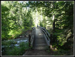 Bridge At Start |
 Queen's Cup |
 Columbine |
 Flat Trail |
 Vanilla Leaf |
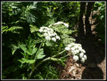 Cow Parsnip |
 Big Penstemon Patch |
 More Penstemon |
 Bouquet |
 Medra Pass In Sight |
 Silver Crown |
 Mt. Stuart Is In Sight |
 Flat Ridge Top |
 Dragontail Peak |
 Mt. Rainier |
 Onions |
 Douglasia |
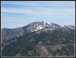 Jolly Mountain |
 Ballhead Waterleaf |
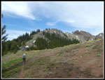 Ridge Hiking |
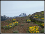 Balsamroot & Mt. Stuart |
 Balsamroot Closeup |
 Steep Ascent |
 Snow Atop Point 5800 |
 Sketchy Trail |
 Rocky Traverse |
 More Mt. Stuart |
 Summit Is Near |
 Hawkins Mountain |
 Fortune & Ingalls Peaks |
 Our Ridge Route |
 Cascade Crest Peaks |
 Gary & John On Summit |
 Heading Down |
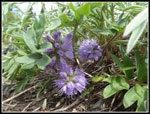
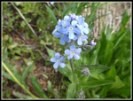 Forget-Me-Nots |
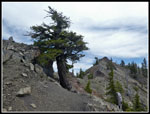 Old Ridge Top Tree |
 Larkspur |
 Tilted Plateau |
 Colorful Penstemon |
 Lupine |
 Lone Indian Paitbrush |
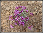
 Columbia Lewisia |
 Penstemon & Stump |
 Last Penstemon |
 Scarlet Gilia |
 Another Columbine |
Trips - 2020
Home