7-11-20
I
hiked up Mt. Teneriffe from the new trailhead for the fist time last
November. Now I have done it twice. My first time up Teneriffe was on
snow in March 1994. I came back in June of 1994. Back then there was
very little info on the route. I just blundered ahead until I found the
summit. If there was a route up Kamikaze Ridge back then I did not know
about it. It was a 13 mile road walk and minimal boot path on the ridge
from road end to summit. Not so any more. Back then I saw nobody on the
route. Now there are well signed trails and no solitude on the summit.
I hoped it would not be too crowded in this time of pandemic. The gate
is listed as opening at 7:00 am. I was on the road at 6:10 am and
pulled in to the 840' lot at 6:56 am. I was on the trail at 7:00 am.
Rain was coming in late afternoon so that was another reason for the
early start. Two folks started a short time ahead of me. There were
about half a dozen cars in the lot. The first two folks stopped and I
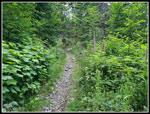
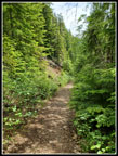
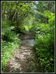
passed them. After half a mile the new trail reached the old road. This
route is very familiar to me. What has chanced was when the road was
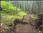
converted to a trail some half dozen or so years ago. It is narrower
and
much more trail like now.
I passed another couple on the old road and when I reached the junction with the route to the falls I saw two more people starting up that trail. Those 6 people were half the total I saw on the way to the summit. Not much elevation gain the first 1.5 miles. At that point the grade steepens and does not let up for the quites some time. It was sunny and 53 degrees when I started. When the grade increased I stopped to zip off my pants legs and switch to a short sleeve shirt. It was plenty warm in the forest with all the elevation gain. They did such a good job narrowing the old road when the climbing begins that it is too narrow for Covid distancing. The narrow section does not go on too long and I did not have to pass anyone going up or down here. While the grade is steep it is consistent and smooth. I was able to keep up a good pace.
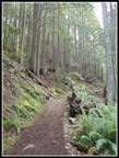
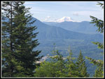
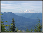
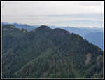
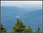
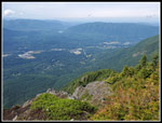
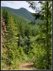
There are a number of switchbacks as the trail continues climbing. There are two trails that now connect to the Mt. Si Trail. At one point I spotted a narrow trail heading off downhill in the brush. I checked my gps map and it was there as the Teneriffe Falls Connector Trail. I had not noticed it before. It is unsigned. Higher up on the switchbacks I met a lone runner coming down. On the last switchback to the right heading over to the Mt. Si junction there is a small viewpoint. I stopped here for a water break and some photos. Some dirt and brush has been removed since last November and now there is once again a pretty good view of Mt. Rainier and Rattlesnake Ledges. Heading higher I heard voices behind me. Just below the Mt. Si junction two guys hiked right on by me. The were going considerably faster. The continued towards Teneriffe at the junction. Most all the junctions are now signed. The Mt. Si junction and the end of the old road have signs and maps showing where you are. At the Mt. Si junction I had hiked 4.2 miles and had 2.3 miles to go.
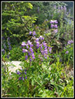
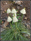
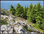
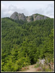
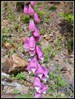
A little more steep climbing above the junction leads to flatter terrain. I saw some wild ginger leaves and a quick check snowed some of their unusual flowers in bloom. I have seen them half a dozen times this year. Much more often than most years. There used to be a big clear cut along here with views out to the south. Now the trees have grown back. Most of it is in forest that blocks the sun. One overhead opening provides a view backwards to the Mt. Si haystack. It is not that far away. The summit of Teneriffe is farther away. I began to see lupine in bloom. Farther along the beargrass display began. Not a lot of beargrass but it was right at peak. I even saw some bleeding hearts still in bloom. The grade even drops a little before climbing more steeply up to the saddle where the road ends. I reached this point at 9:30 am. Just under a mile to go. The bootpath used to climb steeply to the ridge top and follow it. Now there is a trail that switchbacks up the ridge. The dirt is much softer on feet than the old road.
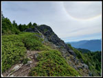
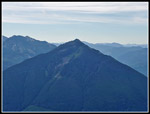
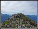
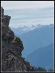
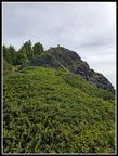
The trail finally reaches the ridge top and is then on a wider version of the old bootpath. Near the false summit it follows the ridge steeply down to another saddle. The trail then switchbacks up Mt. Teneriffe.. High up it crosses under the summit and reaches the much shorter Kamikaze Ridge Trail. There is a nice viewpoint out to the south and east. I stopped for more photos before heading up the last steep climb to the top. This summit trail is narrow and I was fortunate to not meet anyone else going up or down. In just a few minutes I topped out on the 4788' summit. I had hiked 6.5 miles with 3950' of net gain and about 4175' of gross elevation gain. That is a good workout. The two guys who had passed me were on top. Another group was a short ways behind me.
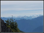
I arrived at 10:00 am. It took me 3:00 to hike up with a few breaks and many photo stops. Last November I logged exactly 3:00 to the summit. I am consistent. Some clouds were coming in but views were still very good. Half of Mt. Baker was in clouds. A little of Mt. Rainier was in clouds. Glacier Peak and most other summits were completely in the clear. I had some food and water and took more photos. There was a light breeze but I did not need to put on a jacket. The wind is usually blowing and it is cool on the summit. Not this morning. My stay was only about 15 minutes. I packed up and headed down at 10:17. At the Kamikaze Ridge junction I stopped for more photos. After that it was time to head down. Most folks come up the shorter route and I hoped that the long trail would no pretty empty this time of morning. I passed three solo hikers in the first 10 minutes. Once back on the road it was crowded for a short distance. I saw a group coming up and stepped off the trail. They went by. Another group was not far behind so i stayed put. The a hiker passed by going down. The two more heading up then two going down. All that while I stayed just off the trail. Many folks put on masks to pass. Some did not. A few minutes down the trail three runners passed me heading up. In a dozen minutes I saw about half the folks seen in just over six hours of hiking. I had quite a bit of solitude for the rest of the hike down.
I made steady progress going down. Over 4000' of elevation loss is easier than gaining it but is hard on the feet on the old road. 6.5 miles of descent is a good workout on its own. I met another group about once a mile the rest of the way down. The exception was the last half mile as there were quite a few groups starting out. I was happy to see the end of the trail. The lot was now almost full. Teneriffe Falls is a much bigger draw than Mt. Teneriffe. The high for the day was supposed to be about 70 degrees but at 1:07 pm it was already in the mid 70s. There was still sunshine but clouds were starting to fill the sky.
This turned out to be an okay pandemic hike. My 7:00 am start allowed for few folks seen on the way up. That one spot coming down was crazy crowded but after that it was not bad at all. Most folks were real good about putting a mask on or holding it over their mouth and nose. Some folks had none and made no effort to move off the trail. I have been doing hikes with few folks and this was a relatively big crowd though small by I-90 standards. I will be avoiding the busiest hikes until the pandemic ends one way or another. I did not get in a single 4000' gain in the first half of the year. In the first two weeks of the second half I have done two of them. It is nice to get in some serious elevation gain once again. I may not get back to Mt. Teneriffe for a few years but I expect o do it again in the not too distant future.
Click on thumbnails to get
larger pictures.
Trips - 2020
Home
I passed another couple on the old road and when I reached the junction with the route to the falls I saw two more people starting up that trail. Those 6 people were half the total I saw on the way to the summit. Not much elevation gain the first 1.5 miles. At that point the grade steepens and does not let up for the quites some time. It was sunny and 53 degrees when I started. When the grade increased I stopped to zip off my pants legs and switch to a short sleeve shirt. It was plenty warm in the forest with all the elevation gain. They did such a good job narrowing the old road when the climbing begins that it is too narrow for Covid distancing. The narrow section does not go on too long and I did not have to pass anyone going up or down here. While the grade is steep it is consistent and smooth. I was able to keep up a good pace.
There are a number of switchbacks as the trail continues climbing. There are two trails that now connect to the Mt. Si Trail. At one point I spotted a narrow trail heading off downhill in the brush. I checked my gps map and it was there as the Teneriffe Falls Connector Trail. I had not noticed it before. It is unsigned. Higher up on the switchbacks I met a lone runner coming down. On the last switchback to the right heading over to the Mt. Si junction there is a small viewpoint. I stopped here for a water break and some photos. Some dirt and brush has been removed since last November and now there is once again a pretty good view of Mt. Rainier and Rattlesnake Ledges. Heading higher I heard voices behind me. Just below the Mt. Si junction two guys hiked right on by me. The were going considerably faster. The continued towards Teneriffe at the junction. Most all the junctions are now signed. The Mt. Si junction and the end of the old road have signs and maps showing where you are. At the Mt. Si junction I had hiked 4.2 miles and had 2.3 miles to go.
A little more steep climbing above the junction leads to flatter terrain. I saw some wild ginger leaves and a quick check snowed some of their unusual flowers in bloom. I have seen them half a dozen times this year. Much more often than most years. There used to be a big clear cut along here with views out to the south. Now the trees have grown back. Most of it is in forest that blocks the sun. One overhead opening provides a view backwards to the Mt. Si haystack. It is not that far away. The summit of Teneriffe is farther away. I began to see lupine in bloom. Farther along the beargrass display began. Not a lot of beargrass but it was right at peak. I even saw some bleeding hearts still in bloom. The grade even drops a little before climbing more steeply up to the saddle where the road ends. I reached this point at 9:30 am. Just under a mile to go. The bootpath used to climb steeply to the ridge top and follow it. Now there is a trail that switchbacks up the ridge. The dirt is much softer on feet than the old road.
The trail finally reaches the ridge top and is then on a wider version of the old bootpath. Near the false summit it follows the ridge steeply down to another saddle. The trail then switchbacks up Mt. Teneriffe.. High up it crosses under the summit and reaches the much shorter Kamikaze Ridge Trail. There is a nice viewpoint out to the south and east. I stopped for more photos before heading up the last steep climb to the top. This summit trail is narrow and I was fortunate to not meet anyone else going up or down. In just a few minutes I topped out on the 4788' summit. I had hiked 6.5 miles with 3950' of net gain and about 4175' of gross elevation gain. That is a good workout. The two guys who had passed me were on top. Another group was a short ways behind me.
I arrived at 10:00 am. It took me 3:00 to hike up with a few breaks and many photo stops. Last November I logged exactly 3:00 to the summit. I am consistent. Some clouds were coming in but views were still very good. Half of Mt. Baker was in clouds. A little of Mt. Rainier was in clouds. Glacier Peak and most other summits were completely in the clear. I had some food and water and took more photos. There was a light breeze but I did not need to put on a jacket. The wind is usually blowing and it is cool on the summit. Not this morning. My stay was only about 15 minutes. I packed up and headed down at 10:17. At the Kamikaze Ridge junction I stopped for more photos. After that it was time to head down. Most folks come up the shorter route and I hoped that the long trail would no pretty empty this time of morning. I passed three solo hikers in the first 10 minutes. Once back on the road it was crowded for a short distance. I saw a group coming up and stepped off the trail. They went by. Another group was not far behind so i stayed put. The a hiker passed by going down. The two more heading up then two going down. All that while I stayed just off the trail. Many folks put on masks to pass. Some did not. A few minutes down the trail three runners passed me heading up. In a dozen minutes I saw about half the folks seen in just over six hours of hiking. I had quite a bit of solitude for the rest of the hike down.
I made steady progress going down. Over 4000' of elevation loss is easier than gaining it but is hard on the feet on the old road. 6.5 miles of descent is a good workout on its own. I met another group about once a mile the rest of the way down. The exception was the last half mile as there were quite a few groups starting out. I was happy to see the end of the trail. The lot was now almost full. Teneriffe Falls is a much bigger draw than Mt. Teneriffe. The high for the day was supposed to be about 70 degrees but at 1:07 pm it was already in the mid 70s. There was still sunshine but clouds were starting to fill the sky.
This turned out to be an okay pandemic hike. My 7:00 am start allowed for few folks seen on the way up. That one spot coming down was crazy crowded but after that it was not bad at all. Most folks were real good about putting a mask on or holding it over their mouth and nose. Some folks had none and made no effort to move off the trail. I have been doing hikes with few folks and this was a relatively big crowd though small by I-90 standards. I will be avoiding the busiest hikes until the pandemic ends one way or another. I did not get in a single 4000' gain in the first half of the year. In the first two weeks of the second half I have done two of them. It is nice to get in some serious elevation gain once again. I may not get back to Mt. Teneriffe for a few years but I expect o do it again in the not too distant future.
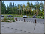 Parking Lot |
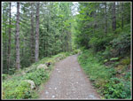 Old Road/Trail |
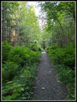 Narrowing Trail |
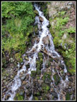 Waterfall |
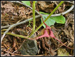
 First Foxglove |
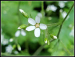 Tiny White Flower |
 Less Brush |
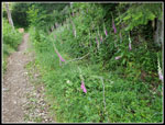 Foxglove Lines Trail |
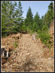 Rocky Road |
 First Viewpoint |
 First Summit View |
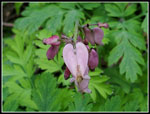 Bleeding Hearts |
 Wild Ginger |
 Lupine |
 Another Rainier View |
 First Beargrass |
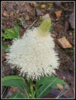 Close Up Beargrass |
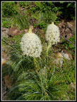 More Beargrass |
 Sign At Road End |
 New Ridge Trail |
 Below Summit |
 Snowy Peaks |
 Mailbox Peak |
 Mt. Teneriffe Summit |
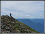 Hiker On Summit |
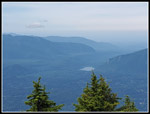 Rattlesnake Lake |
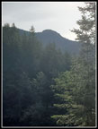
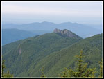 Mt. Si Haystack |
 View North |
 Green Mountain |
 Rattlesnake Ledges |
 Scramble Down |
 View Below Summit |
 Look Up To Summit |
 Snoqualmie Valley |
 Ridge Top Trail |
 Closer Haystack View |
 Trail Below Saddle |
 Last Summit View |
 Foxglove Close Up |
 Colorful Leaf |
 Rock Hop Ahead |
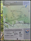
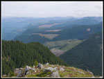
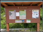 Trailhead Signboard |
Trips - 2020
Home