7-18-20
Gary
was free for a Saturday hike.
We wanted another trip that would not be crowded. We decided on a
favorite loop of mine. The problem is that the easy flat four mile to
Pete Lake is very popular in the summer. We had some concern about
getting two parking spaces. We expected a number of backpackers would
come in on Friday night. With all that in mind, we planned for an early
arrival on Saturday morning. I was on the road at 5:55 am. It takes
about two hours to drive to the trailhead near Cooper Lake. Traffic was
pretty light at that hour. I left a little late but made up the time. I
reached The turn in to the parking lot with one car right in front of
me and several more right behind me. The car ahead parked along the
side of the loop road behind a line of cars. Rather than go through
the lot I chose to park right there. The cars behind me pulled over and
parked too. It was 7:50 am. I put on my hiking shoes, grabbed my pack
and poles and headed down the road to the trailhead. Gary was already
there. We grabbed a wilderness permit and headed onto the trail at abut
7:55 am.
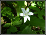
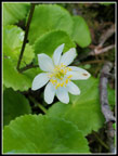
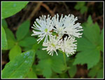
It was a comfortable 53 degrees at the start. We made very good time reaching the trail junction at 1.25 miles. A right turn took us off the popular route. We saw some wildflowers down low though not a lot. Some columbine and bunchberry mostly. The trail starts flat then climbs up to the old road. This road was open for driving when Gary and I started hiking here. Now it has been decommissioned, the bridges and culverts removed, and it is gated at the bottom. A short right turn on the road brought us to Tired Creek and a missing bridge. I did notice that a road ford does allow vehicles to drive across the creek when the flow is low. We took a break here. I started with pants legs zipped off and changed a long sleeve shirt to short sleeves. Most of the day's elevation gain happened in the next 3+ miles. The trail starts out steep and rocky. Soon it turns to switchbacks on smoother tread.
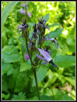
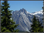
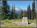
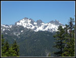
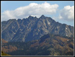
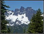
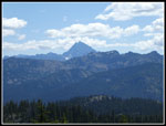
I like this trail is it works its way up the slope. There were some more wildflowers along here. Again, some but not a lot. In a few places we had views out from the forested trail. Snowy Three Queens was clearly visible. To the right we could see Chikamin Peak. We entered the Alpine Wilderness and the grade eased. The upper basin has much better wildflowers. Indian paintbrush was blooming. At the meadows we saw lots of lupine, shooting stars, and elephant head lousewort. Soon we reached the trail junction. Left drops down to Waptus Pass. Right ascends to the Polallie Ridge lookout site. From there it continues to the far east end of the ridge at Salmon La Sac. We went right and climbed to the lookout site. Trees have broken up the clear view in all directions that we had 25 years ago. Still, the view is very good. Moving around we could see most all the peaks. From Three Queens up the crest to Four Brothers, Chikamin Peak, Lemah Mountain, Chimney Rock, Overcoat Peak, The Chiefs, Bears Breast, Hinman, Daniel, The Cradle, and Mt. Stuart plus smaller peaks in between.
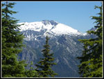
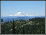
It was very sunny with a few small clouds in the distance. There was little breeze and the bugs were pretty bad. I put on a long sleeve shirt and later a jacket and zipped on pant legs. Even with the bugs we spent a full 67 minutes on top. We arrived at 10:23 am and stayed until 11:30 am. Mt. Rainier was blocked by trees but we dropped into the forest and found a spot with a clear view. As we were about to leave two hikers were arriving. The were hiking along Polallie Ridge. They were the first folks we had seen all day including the trailhead.
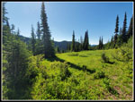
We retraced our route to the junction and headed down to Waptus Pass. An awful lot of trees have fallen across this trail. They have all been cut out. We did not have to climb over any trees on our entire route. Down near the pass we crossed Quick Creek. The trail splits. Left just goes to a large campsite. Right goes over to Waptus Pass which is signed. Right drops to Waptus Lake. We went left on the trail heading for Pete Lake. I like this next section as there are boardwalks and bridges as the trail crosses several meadows. It was getting noticeably warmer in the sunshine. The Waptus Burn trail soon goes off to the right. We stayed left on the trail to Pete Lake. We soon met the third person of the day. Not bad for abut half way around our route.
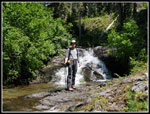
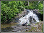
There are several bigger creeks to cross. They were not problem to rock hop across. After passing a larger group of day hiking young women we reached the creek I suggested as our lunch stop. I had made a short stop here but did not recall much other than a small falls just upstream from the crossing. In fact, the conditions were ideal. The water level was low enough to allow sitting next to the falls but high enough to provide a good flow. A most scenic spot. There were some bugs here but not close to as many as at the lookout sight. Our stay went on for half an hour then an hour and finally for 1:40. The second long stop of the hike. A trail crew worker stopped while we were there. He was part of a crew out or six days. They camped at Waptus Lake and worked on all the nearby trails.
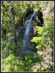
At long last we packed up and were back on our way at 2:36 pm. With our early start we still had lots of time. The trail dropping to Pete Lake had a lot of loose rock on my two previous trips. It still has some but was in better shape overall. We had a look at a waterfall close to the valley bottom. We popped out at Pete Lake to find a few empty campsites and a lot of tents at the ones near the lake. So many tents that we tried but could not find a way to get to the shore without passing close to large groups. I have seen the lake and mountain backdrop many tines. Just not this day.
The last four miles is mostly flat with a number of small ups and downs. They do add up though. We made good time most of the way before catching up with a slightly slower group. Rather than passing we were fine to just keep our distance for the last bit of the hike. I was happy to see the junction with the trail up Tired Creek when we competed our loop. Just 1 1/4 miles to go. We did pass a number of groups on the leg from Pete Lake but it was not that crowded in the afternoon. We arrived back at the trailhead at 5:12 pm. For the day we hiked about 13 1/4 miles with 3400' of elevation gain. A good workout on a sunny but not too hot day. The parking lot was quite full. We had an easy drive home. No hours long delay like our Earl Peak trip a few weeks earlier.
I really enjoy this trip. Some good wildflowers, great views from the lookout site, and not a lot of other people. The two long breaks were highlights of the day. It has been a while since I have taken 2 1/2 hours of break time on a longer than average day hike. A very enjoyable way to spend the day. After two 11 year gaps it was only five years since my last visit. That seems just about right.
Click on thumbnails to get
larger pictures.
Trips - 2020
Home
It was a comfortable 53 degrees at the start. We made very good time reaching the trail junction at 1.25 miles. A right turn took us off the popular route. We saw some wildflowers down low though not a lot. Some columbine and bunchberry mostly. The trail starts flat then climbs up to the old road. This road was open for driving when Gary and I started hiking here. Now it has been decommissioned, the bridges and culverts removed, and it is gated at the bottom. A short right turn on the road brought us to Tired Creek and a missing bridge. I did notice that a road ford does allow vehicles to drive across the creek when the flow is low. We took a break here. I started with pants legs zipped off and changed a long sleeve shirt to short sleeves. Most of the day's elevation gain happened in the next 3+ miles. The trail starts out steep and rocky. Soon it turns to switchbacks on smoother tread.
I like this trail is it works its way up the slope. There were some more wildflowers along here. Again, some but not a lot. In a few places we had views out from the forested trail. Snowy Three Queens was clearly visible. To the right we could see Chikamin Peak. We entered the Alpine Wilderness and the grade eased. The upper basin has much better wildflowers. Indian paintbrush was blooming. At the meadows we saw lots of lupine, shooting stars, and elephant head lousewort. Soon we reached the trail junction. Left drops down to Waptus Pass. Right ascends to the Polallie Ridge lookout site. From there it continues to the far east end of the ridge at Salmon La Sac. We went right and climbed to the lookout site. Trees have broken up the clear view in all directions that we had 25 years ago. Still, the view is very good. Moving around we could see most all the peaks. From Three Queens up the crest to Four Brothers, Chikamin Peak, Lemah Mountain, Chimney Rock, Overcoat Peak, The Chiefs, Bears Breast, Hinman, Daniel, The Cradle, and Mt. Stuart plus smaller peaks in between.
It was very sunny with a few small clouds in the distance. There was little breeze and the bugs were pretty bad. I put on a long sleeve shirt and later a jacket and zipped on pant legs. Even with the bugs we spent a full 67 minutes on top. We arrived at 10:23 am and stayed until 11:30 am. Mt. Rainier was blocked by trees but we dropped into the forest and found a spot with a clear view. As we were about to leave two hikers were arriving. The were hiking along Polallie Ridge. They were the first folks we had seen all day including the trailhead.
We retraced our route to the junction and headed down to Waptus Pass. An awful lot of trees have fallen across this trail. They have all been cut out. We did not have to climb over any trees on our entire route. Down near the pass we crossed Quick Creek. The trail splits. Left just goes to a large campsite. Right goes over to Waptus Pass which is signed. Right drops to Waptus Lake. We went left on the trail heading for Pete Lake. I like this next section as there are boardwalks and bridges as the trail crosses several meadows. It was getting noticeably warmer in the sunshine. The Waptus Burn trail soon goes off to the right. We stayed left on the trail to Pete Lake. We soon met the third person of the day. Not bad for abut half way around our route.
There are several bigger creeks to cross. They were not problem to rock hop across. After passing a larger group of day hiking young women we reached the creek I suggested as our lunch stop. I had made a short stop here but did not recall much other than a small falls just upstream from the crossing. In fact, the conditions were ideal. The water level was low enough to allow sitting next to the falls but high enough to provide a good flow. A most scenic spot. There were some bugs here but not close to as many as at the lookout sight. Our stay went on for half an hour then an hour and finally for 1:40. The second long stop of the hike. A trail crew worker stopped while we were there. He was part of a crew out or six days. They camped at Waptus Lake and worked on all the nearby trails.
At long last we packed up and were back on our way at 2:36 pm. With our early start we still had lots of time. The trail dropping to Pete Lake had a lot of loose rock on my two previous trips. It still has some but was in better shape overall. We had a look at a waterfall close to the valley bottom. We popped out at Pete Lake to find a few empty campsites and a lot of tents at the ones near the lake. So many tents that we tried but could not find a way to get to the shore without passing close to large groups. I have seen the lake and mountain backdrop many tines. Just not this day.
The last four miles is mostly flat with a number of small ups and downs. They do add up though. We made good time most of the way before catching up with a slightly slower group. Rather than passing we were fine to just keep our distance for the last bit of the hike. I was happy to see the junction with the trail up Tired Creek when we competed our loop. Just 1 1/4 miles to go. We did pass a number of groups on the leg from Pete Lake but it was not that crowded in the afternoon. We arrived back at the trailhead at 5:12 pm. For the day we hiked about 13 1/4 miles with 3400' of elevation gain. A good workout on a sunny but not too hot day. The parking lot was quite full. We had an easy drive home. No hours long delay like our Earl Peak trip a few weeks earlier.
I really enjoy this trip. Some good wildflowers, great views from the lookout site, and not a lot of other people. The two long breaks were highlights of the day. It has been a while since I have taken 2 1/2 hours of break time on a longer than average day hike. A very enjoyable way to spend the day. After two 11 year gaps it was only five years since my last visit. That seems just about right.
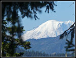 Mt. Rainier |
 Stonecrop |
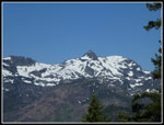 Chikamin Peak |
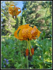 Tiger Lilies |
 Queen's Cup |
 Shooting Stars |
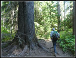
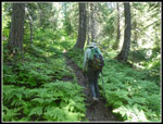 Gary In Forest |
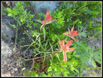 Indian Paintbrush |
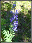 Lupine |
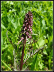 Elephanthead Lousewort |
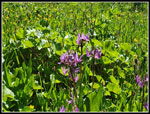 More Shooting Stars |
 Meadow |
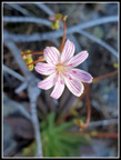 Columbia Lewisia |
 Bear's Breast Mountain |
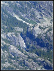 Big Waterfall |
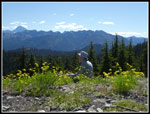 Gary At Lookout Site |
 Three Queens Mountain |
 Mt. Hinman |
 The Chiefs |
 The Cradle |
 Chimney Rock |
 Mt. Rainier Again |
 Mt. Stuart |
 Marsh Marigold |
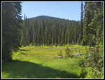 Big Meadow |
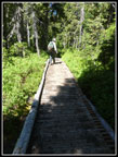 On The Boardwalk |
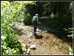 Creek Crossing |
 Long Break Time |
 Gary By Waterfall |
 Small White Flower |
 Another Waterfall |
 Columbine |
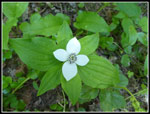 Bunchberry |
 Big Tree |
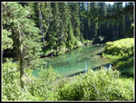 Cooper River |
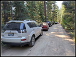 Parked Before Lot |
Trips - 2020
Home