10-24-20
I
wanted to get in a long hike
without seeing many people. How about Wallace Lake State Park? It
usually only has many dozen cars parked down the road from the part.
Sure, why not? In late March
2019 I did this trip via the
logging road instead of the Greg Ball
Trail to the lakes. I saw almost nobody until near the lakes. In a
pandemic year I thought it could work again. With most of the route
being on old railroad grade and logging road it would be easy to pass
folks at a distance too. I was out the door at 7:10 am. Even at that
early hour I hit nearly every light red. Might have been my slowest
ever drive to Wallace Falls SP. I arrived at about 8:10 am. I was on my
way at 8:20 am. The lot was a little less than half full. The weather
forecast called for cold and clearing. The high would not get much over
40 degrees and partly blue sky would become completely blue sky. The
only concern was 9-15 mph winds gusting to 23 mph by late morning. It
was cold and calm when I set out.
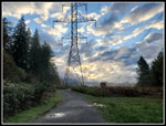
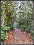
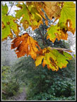
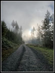
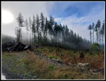
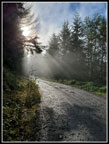
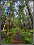
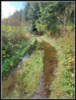
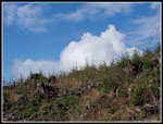
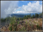
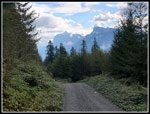
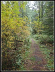
I had to pass one large group that managed to walk four abreast on the initial road/trail leaving no space to get by. After that I saw very few folks for most of the day. No views of Baring, Index, and Persis Mountains from the open road before heading into the forest. Low clouds covered the Skykomish Valley. I quickly reached the junction with the Woody Trail along the river heading to Wallace Falls. The vast majority of folks are going that way. I stayed left on the old railroad grade. There was a little fall color though not a lot. At the 1.5 mile marker I left the grade for the route to the logging road. Way back when I first hiked to the lake the whole logging road route was on a grassy road in forest. When logging returned the old road was widened and covered with gravel. Trees along the sides were cut. It will never be as good as it once was for hikers. It does provide an uncrowded way to get to the lakes. An added feature is that it is several miles longer than the Woody Trail/Greg Ball Trail route.
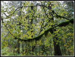
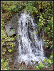
The first .90 miles is on the old narrow soft underfoot old road. There are a few clear cuts along it too now. Once I reached the newer logging road at 2.4 miles the tread was harder though not all that bad to walk on. The grade is never steep and I can make very good time on the road section. I had 3.5 miles of road to the top of the Greg Ball Trail. Along the way I had one truck pass me coming down. At the gravel pit I found a mountain bike with a kid's covered trailer attached. It was gone on my way back. No signs of any people. There are a couple waterfalls along the road and they had plenty of water running.
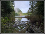
I reached the top of the Greg Ball Trail and a few minutes later I passed two groups heading down from the lake. The first people I had seen since the first mile. I turned off the road onto the the old dirt road to the lake. It's just half a mile long. In the last year or two I found that this soft old dirt road is now piled with large sharp rocks. Okay for the very rare vehicle that goes to the lake. Hard on the feet of the hundreds of hikers between vehicle visits. I really had this section now. Soon enough I was at the lake. The outlet was running very strong. I went onto the bridge for the narrow view down the lake. After that I headed around the lake. It is .70 miles to the inlet creek.
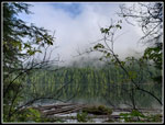
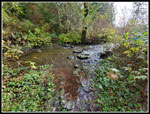
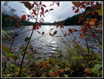
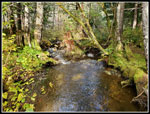
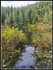
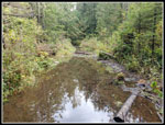
It was noticeably colder in the lake basin. No sun shined through the trees. Speaking of sun, the coming totally clear sky was not coming. Some clearing and quite a bit was white. Nearing the lake inlet the route was partly under water. I had high top waterproof boots and slogged through and around it. In March 2019 the inlet creek was completely dry. An easy walk along the creek bed to Pebble Beach. The lake was low enough for lots of beach to be bare. Not this time. The creek was roaring. It is very brushy on both sides of the creek and challenging to fight through to the lake. I crossed the creek using the four round containers full of rocks. The creek was way over boot top deep. On the other side I could hear the other half of the inlet. It is also dry most of the year. The total inlet water was more than I have ever seen here. Surprising after a dry summer and not all that much recent rain. Clearly, more than I thought.
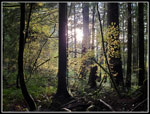
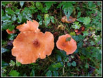
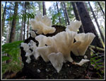
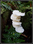
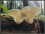
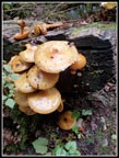
I pushed on through the brush between the creeks. Some devil's club to avoid, down logs to go over. Even some colorful mushrooms. At the edge of the brush was the lake. All of Pebble Beach was under water. Even the lot I usually sit on was mostly buried by water. The beach faces the morning sun and I was not going to get any of it. Temperature in the high 30s and cold forest was the only option. On the positive side, the double digit wind gusting to over 20 mph did not happen all day. Cold but it could have been so much worse. I wore polypro and a long sleeve shirt all the way uphill and now put on a wind shirt. Light gloves were worn most of the day. It is another .80 miles to Jay Lake. I was out for lots of miles so on to Jay I went.
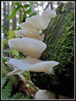
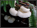
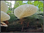
The elevation gain is minimal between Wallace and Jay Lakes. Jay has the only camping spots in the part. I was curious if I would find anyone camping in late October. I did not. On the way I found some very nice white mushrooms covering some logs. My back was a bit sore but they were too good not to get up and down a number of times to photograph them. The creeks along the way were roaring too. One has a bridge over it and one I could just jump across. Jay Lake is lined with tall brush. A couple trails lead through it to views of the lake. This day the lake was high enough to put those trails underwater. I would have had to wade knee deep to get to the normal viewpoint. Not his day. I checked out a new looking outhouse and three tent sites. There is one picnic take a short way from the campsites.
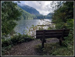
I arrived at Jay Lake at 11:18 am. I left at 11:38 am. It was too dark and cold for my lunch break. It was 8 miles to Jay Lake. I was almost half way in miles. On the way back to Wallace Lake I found a couple more good mushroom patches. Back at Wallace Lake I crossed the first inlet creek on the bridge and the second with the rock containers. I have gone into Pebble Beach from this side of the creek before. I poked around but the brush was really thick. It was very unlikely I would have found any dry ground at the lake shore. anyway. I really wanted to have lunch with some solar radiation shining on me. I recrossed/avoided the big ponds in the trail and reached a side trail that goes down to near the shore. There is a bench there. Unfortunately in late October there is no sunshine. Not high enough in the sky even at noon PDT. I could just see Pebble Beach through tree branches and there was no beach not underwater. I had a quick lunch though it now felt like the mid 30s.
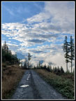
After that I headed back along the lake. At the old road entrance there is a new spur with recent logging. Once off the park property it is private land. I went far enough to get some sunshine and see lots of big white clouds blowing by. Some blue sky but not a whole lot. Next, I headed back to the outlet. A short way beyond the outlet creek is where a creek has made the connection with the route from Upper Wallace Falls challenging after lots of rain. The old road has a big creek running right over it. Several years ago Kim and I could not get across it and had to take a longer road detour that did not reach the lake. I was curious how bad it was at this time. Some work has been done on the problem recently. There are some big rocks lining part of the inundated road. That gets you part way. There was a lot of water blocking the route. Some carefully placed logs and the big rocks look to make it passable in most conditions. Better than I expected. My two detours added one mile. I was now set for a 17 mile day. Back at the Wallace Lake outlet I had just 6.5 miles to go.
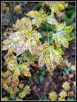
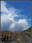
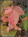
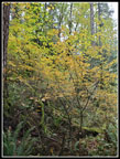
I saw two pairs of hikers near the outlet. I slogged down that crappy rocky road to the main road which is much easier on my feet. On the short walk to the top of the Greg Ball Trail I passed another group coming up to the lake. Once past the trail junction I saw only one guy on a bike over the next 5.5 miles. I did see a few groups on the last 1.5 miles of the old railroad grade. On the road down I had some peek-a-boo views out to Mt. Persis with clouds around the summit. There was not a lot of fall leaf color but I found some along the way. I reached the trailhead at 3:27 pm. I spent 7:07 on the trail hiking 17 miles with 1800' of elevation gain.
This trip met my goals. I wanted to get in a lot of miles. I wanted to not have to worry about passing close by a lot of people during the pandemic. Few folks (one biker?) took my route. I saw nobody between the Wallace Lake outlet, Jay Lake, and back to the Wallace outlet. Leaf colors were not great though I did see some good color. Mushrooms were not prolific but those I saw were right at peak. The lot was full at the end of my day and a few dozen cars were parked down the road between the No Parking signs. Lots of folks went to the falls this day but I had a whole lot of solitude once again. A fine fall day on the trail.
Click on thumbnails to get
larger pictures.
Trips - 2020
Home
I had to pass one large group that managed to walk four abreast on the initial road/trail leaving no space to get by. After that I saw very few folks for most of the day. No views of Baring, Index, and Persis Mountains from the open road before heading into the forest. Low clouds covered the Skykomish Valley. I quickly reached the junction with the Woody Trail along the river heading to Wallace Falls. The vast majority of folks are going that way. I stayed left on the old railroad grade. There was a little fall color though not a lot. At the 1.5 mile marker I left the grade for the route to the logging road. Way back when I first hiked to the lake the whole logging road route was on a grassy road in forest. When logging returned the old road was widened and covered with gravel. Trees along the sides were cut. It will never be as good as it once was for hikers. It does provide an uncrowded way to get to the lakes. An added feature is that it is several miles longer than the Woody Trail/Greg Ball Trail route.
The first .90 miles is on the old narrow soft underfoot old road. There are a few clear cuts along it too now. Once I reached the newer logging road at 2.4 miles the tread was harder though not all that bad to walk on. The grade is never steep and I can make very good time on the road section. I had 3.5 miles of road to the top of the Greg Ball Trail. Along the way I had one truck pass me coming down. At the gravel pit I found a mountain bike with a kid's covered trailer attached. It was gone on my way back. No signs of any people. There are a couple waterfalls along the road and they had plenty of water running.
I reached the top of the Greg Ball Trail and a few minutes later I passed two groups heading down from the lake. The first people I had seen since the first mile. I turned off the road onto the the old dirt road to the lake. It's just half a mile long. In the last year or two I found that this soft old dirt road is now piled with large sharp rocks. Okay for the very rare vehicle that goes to the lake. Hard on the feet of the hundreds of hikers between vehicle visits. I really had this section now. Soon enough I was at the lake. The outlet was running very strong. I went onto the bridge for the narrow view down the lake. After that I headed around the lake. It is .70 miles to the inlet creek.
It was noticeably colder in the lake basin. No sun shined through the trees. Speaking of sun, the coming totally clear sky was not coming. Some clearing and quite a bit was white. Nearing the lake inlet the route was partly under water. I had high top waterproof boots and slogged through and around it. In March 2019 the inlet creek was completely dry. An easy walk along the creek bed to Pebble Beach. The lake was low enough for lots of beach to be bare. Not this time. The creek was roaring. It is very brushy on both sides of the creek and challenging to fight through to the lake. I crossed the creek using the four round containers full of rocks. The creek was way over boot top deep. On the other side I could hear the other half of the inlet. It is also dry most of the year. The total inlet water was more than I have ever seen here. Surprising after a dry summer and not all that much recent rain. Clearly, more than I thought.
I pushed on through the brush between the creeks. Some devil's club to avoid, down logs to go over. Even some colorful mushrooms. At the edge of the brush was the lake. All of Pebble Beach was under water. Even the lot I usually sit on was mostly buried by water. The beach faces the morning sun and I was not going to get any of it. Temperature in the high 30s and cold forest was the only option. On the positive side, the double digit wind gusting to over 20 mph did not happen all day. Cold but it could have been so much worse. I wore polypro and a long sleeve shirt all the way uphill and now put on a wind shirt. Light gloves were worn most of the day. It is another .80 miles to Jay Lake. I was out for lots of miles so on to Jay I went.
The elevation gain is minimal between Wallace and Jay Lakes. Jay has the only camping spots in the part. I was curious if I would find anyone camping in late October. I did not. On the way I found some very nice white mushrooms covering some logs. My back was a bit sore but they were too good not to get up and down a number of times to photograph them. The creeks along the way were roaring too. One has a bridge over it and one I could just jump across. Jay Lake is lined with tall brush. A couple trails lead through it to views of the lake. This day the lake was high enough to put those trails underwater. I would have had to wade knee deep to get to the normal viewpoint. Not his day. I checked out a new looking outhouse and three tent sites. There is one picnic take a short way from the campsites.
I arrived at Jay Lake at 11:18 am. I left at 11:38 am. It was too dark and cold for my lunch break. It was 8 miles to Jay Lake. I was almost half way in miles. On the way back to Wallace Lake I found a couple more good mushroom patches. Back at Wallace Lake I crossed the first inlet creek on the bridge and the second with the rock containers. I have gone into Pebble Beach from this side of the creek before. I poked around but the brush was really thick. It was very unlikely I would have found any dry ground at the lake shore. anyway. I really wanted to have lunch with some solar radiation shining on me. I recrossed/avoided the big ponds in the trail and reached a side trail that goes down to near the shore. There is a bench there. Unfortunately in late October there is no sunshine. Not high enough in the sky even at noon PDT. I could just see Pebble Beach through tree branches and there was no beach not underwater. I had a quick lunch though it now felt like the mid 30s.
After that I headed back along the lake. At the old road entrance there is a new spur with recent logging. Once off the park property it is private land. I went far enough to get some sunshine and see lots of big white clouds blowing by. Some blue sky but not a whole lot. Next, I headed back to the outlet. A short way beyond the outlet creek is where a creek has made the connection with the route from Upper Wallace Falls challenging after lots of rain. The old road has a big creek running right over it. Several years ago Kim and I could not get across it and had to take a longer road detour that did not reach the lake. I was curious how bad it was at this time. Some work has been done on the problem recently. There are some big rocks lining part of the inundated road. That gets you part way. There was a lot of water blocking the route. Some carefully placed logs and the big rocks look to make it passable in most conditions. Better than I expected. My two detours added one mile. I was now set for a 17 mile day. Back at the Wallace Lake outlet I had just 6.5 miles to go.
I saw two pairs of hikers near the outlet. I slogged down that crappy rocky road to the main road which is much easier on my feet. On the short walk to the top of the Greg Ball Trail I passed another group coming up to the lake. Once past the trail junction I saw only one guy on a bike over the next 5.5 miles. I did see a few groups on the last 1.5 miles of the old railroad grade. On the road down I had some peek-a-boo views out to Mt. Persis with clouds around the summit. There was not a lot of fall leaf color but I found some along the way. I reached the trailhead at 3:27 pm. I spent 7:07 on the trail hiking 17 miles with 1800' of elevation gain.
This trip met my goals. I wanted to get in a lot of miles. I wanted to not have to worry about passing close by a lot of people during the pandemic. Few folks (one biker?) took my route. I saw nobody between the Wallace Lake outlet, Jay Lake, and back to the Wallace outlet. Leaf colors were not great though I did see some good color. Mushrooms were not prolific but those I saw were right at peak. The lot was full at the end of my day and a few dozen cars were parked down the road between the No Parking signs. Lots of folks went to the falls this day but I had a whole lot of solitude once again. A fine fall day on the trail.
 No Morning Views |
 Mossy Trees |
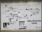 State Park Map |
 Light & Dark |
 Changing Color |
 Leaves & Moss |
 Spotted Leaves |
 Clouds Above Road |
 Clouds Ahead |
 Waterfall |
 Wall Of Trees |
 Sunbeams |
 Wallace Lake Outlet |
 Wallace Lake |
 Inlet Creek |
 Orange Shrooms |
 Wallace Lake Shore |
 Second Inlet Creek |
 Jay Lake Trail |
 First Mushrooms |
 Jay Lake |
 Great Contrast |
 Look Up At Shrooms |
 More Mushrooms |
 Great Mushrooms |
 One More |
 Trail Underwater |
 Lunch Spot |
 Big White Clouds |
 Tall Clouds |
 Skykomish Valley |
 Underwater Trail |
 Index & Persis Mts. |
 Red Leaf |
 Rake Needed? |
 New Map |
 Some Leaf Color |
 More Color |
 Last Mushrooms |
 Map & Mt. Views |
Trips - 2020
Home