4-11-21
Since
the pandemic began I have
looked for hikes that with short drives, longer distances, and few
people. This one fits the bill. Who wants to walk a logging road to get
to a summit in 6.7 miles that you can hike to largely on trail in under
4 miles. Well, me for one during a pandemic. I first hiked this route
in January 2010 and again last year in August. There was recent
snowfall
as low as 1200' in the past few days. Unusual for this late in the
year. With a summit at 3000' I did not know if there would be much snow
high on the route. I brought poles and microspikes just in
case.
I planned to be on the road by 7:00 am but it was only 25 degrees in
Preston. I waited until 7:20 am instead. I arrived at the 1090'' gate
right on Highway 18 at 8:00 am. It was 31 degrees. I stated hiking at
8:05 am. Cold in the shade
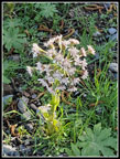
but the sky was clear for a change. I found some wildflowers in bloom
right at the gate.
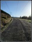
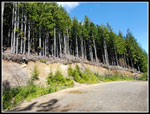
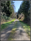
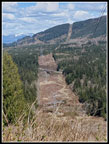
The road climbs quickly to run alongside the powerlines. It was cold but the sunshine felt pretty good. After half a mile the road leaves the powerlines and heads into the forest. First I stopped to look across to West Rattlesnake Mountain's towers. I could also see some snow on peaks to the north. The low sunshine was a bit blinding looking east. As I headed into the forest I saw a lone patch of blooming skunk cabbage just off the road. It was the only ones I saw all day. Earlier in the week I saw a number of spring wildflowers low down on West Tiger Mountain. I did not see much this day on the way up East Tiger. The route crosses a bike path that drops down to the Raging River and goes under Highway 18 connecting to the Rattlesnake Mountain bike trails network. I went by 9 other bike trails on the way up. At 1.3 miles I reached the Northwest Timber Trail. Right there heavy equipment is quarrying rock for more logging spurs. A sign mentioned there is active logging ahead. I will not be hiking here on a weekday for some time.
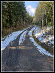
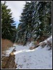
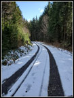
After climbing from the gate at the start the grade is pretty gentle for the first 3 miles. Most of the elevation gain is in the second half of the route. Way back about a mile in I saw a small patch of snow off the road. That was it until well past four miles. I passed the Preston RR Grade, the new silent swamp trail, and another trail up to the Preston Grade. After 4 miles I had seen two bikers coming down and one runner. A biker than crossed the road from Fully Rigid to the Off The Grid Trail. Perfect timing. A minute or two earlier and we would not have seen each other. At the Master Link - Quick Link Trail crossing there were a couple bikers. Snow was now more than a little patchy. By the time I reached the upper end of the Quick Link there were more bikers and the snow covered all but a single tire track.
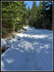
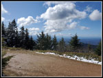
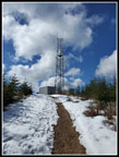
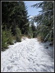
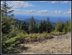
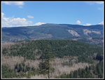
I crested the hill and dropped down to the junction with the spur road up East Tiger. I was now miles along with just .70 miles to go. There was a little bare road before the snow became solid. It was also icy. Poles were helpful. I decided not to stop and put on microspikes. My pace slowed down as I slogged up the last part. I reached the summit at 10:33 am. I took 2:28 to climb the 6.7 miles. Last August with light boots and pack and no snow I hiked up in 2:16. Not too bad. I saw about a dozen folks in nearly 7 miles. That was what I was looking for. There was a lot of blue sky and some big puffy clouds. Really nice scenery. The only disappointment was the big clouds right where Mt. Rainier would be. On last year's trip I descended the summit spur and climbed back to the summit. This added 1.4 miles and 350' of gain. I planned to do it again this day if the snow did not add too much effort. It did not. I was not thrilled with doing the icy snow twice but I wanted to get in 14.8 miles.
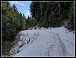
I headed down at 11:00 am and it only took 15 minutes to descend. The icy snow had already softened up a little. One more climb up and a shorter stay on the summit. At 11:45 am I was already heading down. I was sip sliding faster new. Two runners sped by uphill. They and the one runner early were the only non bikers I saw. Not even one hiker was seen this day. I was on snow down past the Quick Link and soon it was patchy snow then below the Master Link it was easy walking again. I was getting a bit tired by the time I reached the sign marking 3.2 miles back to Highway 18. By then the steeper grade gave way to the much gentler section. No more gravity pulling me along.
I did not see many folks while descending. Just a few random bikes mostly at places where bike trails reached the road. Almost 15 miles on road has been flaring up a little plantar fasciitis near the end. This day it was not bad at all. Going uphill I had cold hands but stayed warm enough. Going downhill it was now warmer but with less effort I was colder. At the half mile mark I left the forest and it was very nice to be out in the warmer sunshine. I reached my car at 2:13 pm. I took 2:28 to descend. It was the same time as going up. I did take a few breaks coming down. The longest was at the half mile mark where I had views out and lots of sunshine.
The trip turned out just as I had hoped. 14.8 miles is a long hike, especially with snow for several miles. The gain was 2400' but only with the extra 350' from a second summit climb. I did see a number of mountain bikers but the were mostly near the summit and at places trails met the road. There were many long stretches where I saw nobody. Passing bikes on a wide road is not a concern during a pandemic. Not like passing 400 to 500 hikers on Mt. Si. This is not a route I will do often but it has served me well over the past year.
Click on thumbnails to get
larger pictures.
Trips - 2021
Home
The road climbs quickly to run alongside the powerlines. It was cold but the sunshine felt pretty good. After half a mile the road leaves the powerlines and heads into the forest. First I stopped to look across to West Rattlesnake Mountain's towers. I could also see some snow on peaks to the north. The low sunshine was a bit blinding looking east. As I headed into the forest I saw a lone patch of blooming skunk cabbage just off the road. It was the only ones I saw all day. Earlier in the week I saw a number of spring wildflowers low down on West Tiger Mountain. I did not see much this day on the way up East Tiger. The route crosses a bike path that drops down to the Raging River and goes under Highway 18 connecting to the Rattlesnake Mountain bike trails network. I went by 9 other bike trails on the way up. At 1.3 miles I reached the Northwest Timber Trail. Right there heavy equipment is quarrying rock for more logging spurs. A sign mentioned there is active logging ahead. I will not be hiking here on a weekday for some time.
After climbing from the gate at the start the grade is pretty gentle for the first 3 miles. Most of the elevation gain is in the second half of the route. Way back about a mile in I saw a small patch of snow off the road. That was it until well past four miles. I passed the Preston RR Grade, the new silent swamp trail, and another trail up to the Preston Grade. After 4 miles I had seen two bikers coming down and one runner. A biker than crossed the road from Fully Rigid to the Off The Grid Trail. Perfect timing. A minute or two earlier and we would not have seen each other. At the Master Link - Quick Link Trail crossing there were a couple bikers. Snow was now more than a little patchy. By the time I reached the upper end of the Quick Link there were more bikers and the snow covered all but a single tire track.
I crested the hill and dropped down to the junction with the spur road up East Tiger. I was now miles along with just .70 miles to go. There was a little bare road before the snow became solid. It was also icy. Poles were helpful. I decided not to stop and put on microspikes. My pace slowed down as I slogged up the last part. I reached the summit at 10:33 am. I took 2:28 to climb the 6.7 miles. Last August with light boots and pack and no snow I hiked up in 2:16. Not too bad. I saw about a dozen folks in nearly 7 miles. That was what I was looking for. There was a lot of blue sky and some big puffy clouds. Really nice scenery. The only disappointment was the big clouds right where Mt. Rainier would be. On last year's trip I descended the summit spur and climbed back to the summit. This added 1.4 miles and 350' of gain. I planned to do it again this day if the snow did not add too much effort. It did not. I was not thrilled with doing the icy snow twice but I wanted to get in 14.8 miles.
I headed down at 11:00 am and it only took 15 minutes to descend. The icy snow had already softened up a little. One more climb up and a shorter stay on the summit. At 11:45 am I was already heading down. I was sip sliding faster new. Two runners sped by uphill. They and the one runner early were the only non bikers I saw. Not even one hiker was seen this day. I was on snow down past the Quick Link and soon it was patchy snow then below the Master Link it was easy walking again. I was getting a bit tired by the time I reached the sign marking 3.2 miles back to Highway 18. By then the steeper grade gave way to the much gentler section. No more gravity pulling me along.
I did not see many folks while descending. Just a few random bikes mostly at places where bike trails reached the road. Almost 15 miles on road has been flaring up a little plantar fasciitis near the end. This day it was not bad at all. Going uphill I had cold hands but stayed warm enough. Going downhill it was now warmer but with less effort I was colder. At the half mile mark I left the forest and it was very nice to be out in the warmer sunshine. I reached my car at 2:13 pm. I took 2:28 to descend. It was the same time as going up. I did take a few breaks coming down. The longest was at the half mile mark where I had views out and lots of sunshine.
The trip turned out just as I had hoped. 14.8 miles is a long hike, especially with snow for several miles. The gain was 2400' but only with the extra 350' from a second summit climb. I did see a number of mountain bikers but the were mostly near the summit and at places trails met the road. There were many long stretches where I saw nobody. Passing bikes on a wide road is not a concern during a pandemic. Not like passing 400 to 500 hikers on Mt. Si. This is not a route I will do often but it has served me well over the past year.
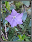 First Wildflower |
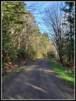
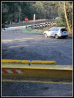 Parking Spot & Gate |
 Low Sun & Blue Sky |
 Skunk Cabbage |
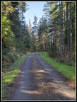
 Shady Road |
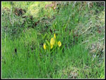
 Colt's Foot |
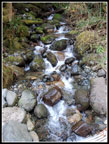 Cascading Creek |
 Solitude |
 Snow Starts |
 Solid Snow Cover |
 East Tiger Summit |
 Heading Down |
 Snowy Trees |
 Slogging Down |
 View Of South Tiger Mt |
 Downward High Point |
 Bare Spots Now |
 Sunny Spot |
 Bikers At Junction |
 Mt. Teneriffe |
 Grade Flattens |
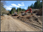 Quarrying Work |
 Powerlines & Rattlesnake |
 Rattlesnake Towers |
Trips - 2021
Home