10-03-21
Last
week Gary and I headed over
Jack Pass to the NF Skykomish River and a backpacking trip up West Cady
Ridge to Benchmark Mountain. It had me thinking about the new trail
under construction on Frog Mountain just above Jack Pass. There was
little information available. I did see a Forest Service map that
included the trail. I also read that the trail was just under 4 miles
long to the summit. A few earlier trip reports mentioned that most of
the trail was in place with a missing section in the middle. I
mentioned
hoping to check it out before winter to Kim and she suggested we go on
Sunday. Well, why not As it turned out Sunday would be the last day of
the baseball season and the Mariners had a chance to make the playoffs
for the first time since 2001. The Seahawks were on too. Well, with
47,000 folks at the ballpark and tens of thousands more watching on
television perhaps Highway 2 would not be backed up 20 miles from
Sultan. It was prime larch time, however. It was also supposed to be
largely overcast. With all that, I agreed to checking out Frog Mountain.
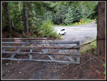
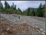
We met in Shoreline at 6:50 am and headed east. Steady traffic but not too bad. No traffic on the Beckler River Road. No cars at Jack Pass. I had the wiper on much of the drive to Skykomish. It was very cloudy but dry at the pass. We packed up and were on our way at 8:33 am. The road walk is very short. We quickly arrived at a quarry. Heavy equipment was on site. The dirt was pretty mucky with recent rain. They still have some work to do before this will be a usable trailhead parking lot. The start of the trail was pretty obvious though unsigned.
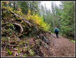
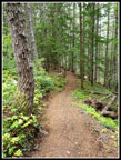
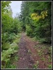
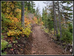
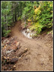
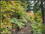
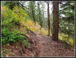
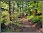
The route starts on an old road. It has not been used in a long time. A little rocky but pretty nice for a road. In a couple of places the road is underwater. The trail leaves the road for higher ground before meeting the old road once again. In this section, there are half a dozen or more removed culvert spots. One must drop down and climb back up the other side. After the road, there are virtually no spots where the trail crosses a creek. Even with the recent rain, the route was dry. Within a half-mile or so the new trail leaves the old road. Now it is smooth sailing. Very smooth. I can't recall any steps or roots or rocks on the trail. The distance to the summit in a straight line can't be more than about 2 miles. The trail has a number of long switchbacks to get up to the 4 miles. With 2200' gained it is just over a 10% average grade. Not really steep at all.
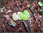
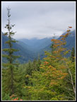
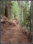
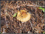
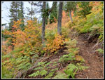
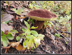
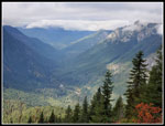
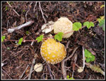
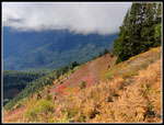
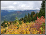
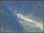
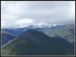
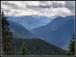
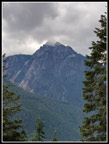
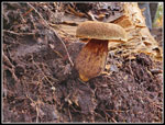
We expected to take lots of photos and move along at a slow pace. Mission accomplished. The recent rain has really had mushrooms popping up on all my recent trips. This was no exception. We saw many different varieties. The lower trail was likely built with a mini excavator. It is wide and smooth. Not overly wide, however. As the dirt wall sloughs off the trail will naturally narrow. At about 3600' we entered the Wild Sky Wilderness. The trail changed. It became a little narrower. It looks like the excavator gave way to hand built trail in the wilderness. The trail is still very nice just a bit different. About 2 miles up things began to change. What had been a forest walk now had some open sections. These provided views across the pass to San Juan Hill and Bear Mountain and down to the NF Skykomish River. The peaks above were partly in clouds. We were getting closer to the cloud level.
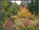
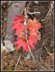
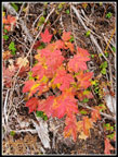
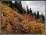
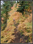
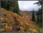
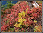
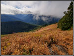
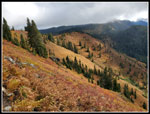
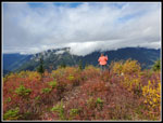
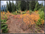
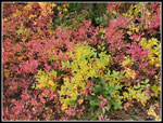
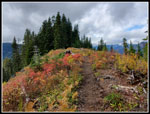
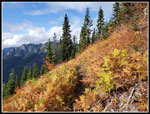
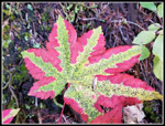
The open slope spots also added mountain ash and berry bushes in their fall colors. Without the sunshine, they were not brightly colored but still pretty nice. At 4150' we stopped for food and water. I had breakfast at 6:00 am and it was now 10:55 am. We just had 650' of gain to go. After about 15 minutes we were back on our way. The trail was now more out in the open than in forest. On a clear day, the views would have been great. The clouds did add a moodiness to the trip. Not all bad after a long dry and sunny summer. At 4600' we were on a flat section of the summit ridge. Now just 250' below the summit and only about 210' below the end of the trail. More forest here with a lot of mushrooms. One spot was open with some great views on a clear day. When the ridge again begins to climb the route has a few short switchbacks then begins a traverse below the summit on open slopes of brightly fall colored bushes. To the south is Evergreen Mountain with Mts. Daniel, Hinman, and many other peaks.
One final short climb brought us to a small meadow just east and below the main summit. As of now, it is just a narrow trail to a small clear patch. When the trail opens this meadow will inevitably become a larger bald spot. Too many boots will need to trod it all to find places to sit and enjoy the views. We took a few photos to remember how it was at first. Kim and I did the same thing at the summit of Beckler Peak before that trail opened. All the mossy rocks on top were bare within a year. Just part of the new trail experience.
We arrived on top at 12:20 pm. The week before, backpacking on West Cady Ridge, I had great views of Glacier Peak, The Monte Cristo Peaks, Daniel, Hinman, Overcoat, Chimney Rock, and the Wild Sky Peaks. This spot has most of them and closer views of Baring, Gunn, Merchant, and the other Wild Sky Peaks. We did not have them this day but I will see them from here soon. We had a few short sun breaks on the way up and a bigger one on top. Still cloudy peaks but a lot of solar warming hitting us. We spent over an hour on top. Since we were coming home on Highway 2 on a Sunday during the peak of fall colors and the first weekend of Octoberfest in Leavenworth, we needed to get moving before we wanted to. I already imagined miles of backed-up traffic and it would be worse later on. We packed up and headed down at 1:30 pm. Below the summit, there are some amazing slopes of bushes that were in fall colors. More photo stops. The traverse under the summit is on a ridiculously steep slope. If you fell off the trail you would go a long way. Just be careful and it is fine.
The trail is so smooth and soft that it was very easy on the feet and knees. Another plus for this trail. Somewhere above the halfway point is the last part of the trial to be built. The dirt is still very soft. Some additional touch up work may be needed before it is ready for many feet and a grand opening. We took fewer photos coming down but still did have a number of stops. As expected we saw nobody all day long. We were not hiking fast but did cut a log of time off our uphill pace. We reached the car at 3:47 pm. We took about an hour and a half less on the descent. The ever popular Blanca Lake trailhead is on the north side of Jack Pass and we immediately started seeing cars coming up and over heading for Highway 2. We were on our way back just after 4:00 pm.
On the drive home we did the speed limit until just after the turn-off for the town of Index. I was very disappointed when we came to a full stop. Quickly we started moving and kept it up until almost into Gold Bar. From there it was slow with some stop and go until the west end of Sultan. It probably added about 45 minutes to our time in the morning. Still, not nearly as bad as I had feared. Oh, and the Mariners failed to make the playoffs for the 20th consecutive year. Just as well I went hiking as stay home to watch the game.
When the parking lot is finished with a toilet installed and some more touch-up work is done to the trail it will open to much acclaim. Beckler Peak provided the first short trail to a viewpoint off Highway 2. This will be the second. Beckler became overly crowded very fast. So will Frog Mountain. I was glad to hike this trail before the crowds. When I am retired I will probably hike up it midweek fairly often. A lot of bang for the buck on an 8 mile round trip hike.
Click on thumbnails to get
larger pictures.
Trips - 2021
Home
We met in Shoreline at 6:50 am and headed east. Steady traffic but not too bad. No traffic on the Beckler River Road. No cars at Jack Pass. I had the wiper on much of the drive to Skykomish. It was very cloudy but dry at the pass. We packed up and were on our way at 8:33 am. The road walk is very short. We quickly arrived at a quarry. Heavy equipment was on site. The dirt was pretty mucky with recent rain. They still have some work to do before this will be a usable trailhead parking lot. The start of the trail was pretty obvious though unsigned.
The route starts on an old road. It has not been used in a long time. A little rocky but pretty nice for a road. In a couple of places the road is underwater. The trail leaves the road for higher ground before meeting the old road once again. In this section, there are half a dozen or more removed culvert spots. One must drop down and climb back up the other side. After the road, there are virtually no spots where the trail crosses a creek. Even with the recent rain, the route was dry. Within a half-mile or so the new trail leaves the old road. Now it is smooth sailing. Very smooth. I can't recall any steps or roots or rocks on the trail. The distance to the summit in a straight line can't be more than about 2 miles. The trail has a number of long switchbacks to get up to the 4 miles. With 2200' gained it is just over a 10% average grade. Not really steep at all.
We expected to take lots of photos and move along at a slow pace. Mission accomplished. The recent rain has really had mushrooms popping up on all my recent trips. This was no exception. We saw many different varieties. The lower trail was likely built with a mini excavator. It is wide and smooth. Not overly wide, however. As the dirt wall sloughs off the trail will naturally narrow. At about 3600' we entered the Wild Sky Wilderness. The trail changed. It became a little narrower. It looks like the excavator gave way to hand built trail in the wilderness. The trail is still very nice just a bit different. About 2 miles up things began to change. What had been a forest walk now had some open sections. These provided views across the pass to San Juan Hill and Bear Mountain and down to the NF Skykomish River. The peaks above were partly in clouds. We were getting closer to the cloud level.
The open slope spots also added mountain ash and berry bushes in their fall colors. Without the sunshine, they were not brightly colored but still pretty nice. At 4150' we stopped for food and water. I had breakfast at 6:00 am and it was now 10:55 am. We just had 650' of gain to go. After about 15 minutes we were back on our way. The trail was now more out in the open than in forest. On a clear day, the views would have been great. The clouds did add a moodiness to the trip. Not all bad after a long dry and sunny summer. At 4600' we were on a flat section of the summit ridge. Now just 250' below the summit and only about 210' below the end of the trail. More forest here with a lot of mushrooms. One spot was open with some great views on a clear day. When the ridge again begins to climb the route has a few short switchbacks then begins a traverse below the summit on open slopes of brightly fall colored bushes. To the south is Evergreen Mountain with Mts. Daniel, Hinman, and many other peaks.
One final short climb brought us to a small meadow just east and below the main summit. As of now, it is just a narrow trail to a small clear patch. When the trail opens this meadow will inevitably become a larger bald spot. Too many boots will need to trod it all to find places to sit and enjoy the views. We took a few photos to remember how it was at first. Kim and I did the same thing at the summit of Beckler Peak before that trail opened. All the mossy rocks on top were bare within a year. Just part of the new trail experience.
We arrived on top at 12:20 pm. The week before, backpacking on West Cady Ridge, I had great views of Glacier Peak, The Monte Cristo Peaks, Daniel, Hinman, Overcoat, Chimney Rock, and the Wild Sky Peaks. This spot has most of them and closer views of Baring, Gunn, Merchant, and the other Wild Sky Peaks. We did not have them this day but I will see them from here soon. We had a few short sun breaks on the way up and a bigger one on top. Still cloudy peaks but a lot of solar warming hitting us. We spent over an hour on top. Since we were coming home on Highway 2 on a Sunday during the peak of fall colors and the first weekend of Octoberfest in Leavenworth, we needed to get moving before we wanted to. I already imagined miles of backed-up traffic and it would be worse later on. We packed up and headed down at 1:30 pm. Below the summit, there are some amazing slopes of bushes that were in fall colors. More photo stops. The traverse under the summit is on a ridiculously steep slope. If you fell off the trail you would go a long way. Just be careful and it is fine.
The trail is so smooth and soft that it was very easy on the feet and knees. Another plus for this trail. Somewhere above the halfway point is the last part of the trial to be built. The dirt is still very soft. Some additional touch up work may be needed before it is ready for many feet and a grand opening. We took fewer photos coming down but still did have a number of stops. As expected we saw nobody all day long. We were not hiking fast but did cut a log of time off our uphill pace. We reached the car at 3:47 pm. We took about an hour and a half less on the descent. The ever popular Blanca Lake trailhead is on the north side of Jack Pass and we immediately started seeing cars coming up and over heading for Highway 2. We were on our way back just after 4:00 pm.
On the drive home we did the speed limit until just after the turn-off for the town of Index. I was very disappointed when we came to a full stop. Quickly we started moving and kept it up until almost into Gold Bar. From there it was slow with some stop and go until the west end of Sultan. It probably added about 45 minutes to our time in the morning. Still, not nearly as bad as I had feared. Oh, and the Mariners failed to make the playoffs for the 20th consecutive year. Just as well I went hiking as stay home to watch the game.
When the parking lot is finished with a toilet installed and some more touch-up work is done to the trail it will open to much acclaim. Beckler Peak provided the first short trail to a viewpoint off Highway 2. This will be the second. Beckler became overly crowded very fast. So will Frog Mountain. I was glad to hike this trail before the crowds. When I am retired I will probably hike up it midweek fairly often. A lot of bang for the buck on an 8 mile round trip hike.
 Frog Mt. Map |
 Gate At Jack Pass |
 Quarry |
 Kim On New Trail |
 Almost Twins |
 New Trail |
 Old Road Section |
 Fall Color Starting |
 Nice Wide Trail |
 First View Out |
 Ess Turn |
 Newer Section |
 Brushy Colors |
 Mushroom |
 Bright Colors |
 More Open Now |
 More Vine Maple |
 Kim On Trail |
 Golden Ferns |
 Throw Pillow Shroom |
 Even More Ferns |
 NF Sky Valley |
 Colorful Slopes |
 More Mushrooms |
 Multi Colors |
 Looking Back |
 Changing Lighting |
 Gorgeous |
 Sunny Overhead |
 Old Snow In October |
 Kim On Top |
 Green Obelisk |
 Peaks To The North |
 Summit Meadow |
 Many Colors |
 Beckler Valley |
 Heading Down |
 Bear Mountain |
 Sunny Slope |
 One More Mushroom |
 Sunny Forest |
 Crazy Colorful Leaf |
Trips - 2021
Home