9-11-21
I
had
known of this trail for many years. Kim raved about a backpacking trip
she did on it. Gary mentioned it several years ago. I suggested it to
Gary for this weekend. He agreed. It is a long drive from North Seattle
so I was on the road at 6:13 am. The main I-5 roadway was closed for
long overdue reconstruction so traffic was detoured on the
collector/distributor bypass. Traffic was moderate even at that hour
but the delay was very minimal. I picked Gary up at his house in Kent
and we headed south and east. There was a stream of traffic heading to
the White River entrance to Mount Rainier NP. After they turned off
there was no more traffic. I could see Mount Rainier from Seattle.
Seattle was under clouds but Rainier was in the clear. Unfortunately,
there were low clouds and we drove into them going up to Cayuse Pass.
Minimal visibility and a huge drop off the side with no guard rails is
not my favorite driving conditions. I drove slow. It cleared a bit at
Cayuse Pass then we dropped back into the pea soup. We parked on the
side of the road right after the turnoff for the Stevens Canyon Road.
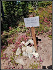
We had a short walk to the start of the trail at abut 2200'. We started
up the trail at 8:29 am.
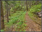
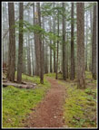
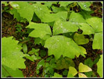
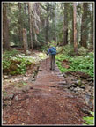
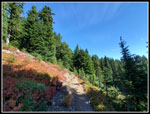
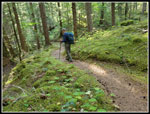
The trail starts climbing immediately. It continues to climb most of the way. What it does not do is climb steeply. Just a steady grade of about 10% or a little less. Over miles that does add up. Lots of mossy ground in the first parts. Not a lot of underbrush. The most noticeable thing is the soft tread. This trail is easy on the feet. Most 10 mile hikes leave my feet sorer than 16 miles on this route. After a very rocky trip last Monday it was very much appreciated. The trail is sometimes near the creek but more often at a distance. The creek is mostly in a gorge below the trail. We saw only one side creek near a switchback that had any steady flow. Lots of bridges with dry rocks underneath. It was a cool 51 degrees when we started and never made it above the mid 60s. Two quarts of water was enough this day.
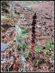
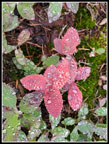
The trail climbs up a ridge then the grade eases. There are only two descents of even 100' all day. One drops down to near a pond at about 1.4 miles. It rained the day before but not much during the past few months. The pond was at a low level. As we hiked farther we began to see saprophytes. I saw a lot of them a month or so earlier. Many of these were past prime. Candystick was finished or at least the tops were but some red and white stripes remained lower down. When we reached the pine drops they were near peak. Some were nearly three feet tall. One patch had more than 20 of them. This trail would have been even more spectacular a month ago. The pine drops still were great.
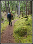
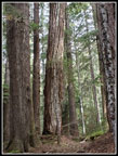
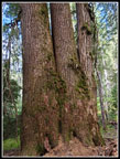
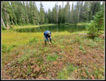
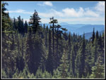
Trees down low seemed pretty small to me. By the three mile point this changed markedly. Lots of big trees and some really big ones. Still mostly Douglas Fir at this elevation. We took a food and water break right before the 3.5 mile point. We noticed a tree 40' or so below the trail. Not obvious while hiking by but easy to see if you are looking. It is huge. I went down to it and Gary took some photos. My arm span is 6.5 feet. That did not cover one side. I would guess the circumference to be about 24 feet. We continued on gaining elevation continuously. At about 5 miles in we met a couple backpackers coming out. After the rain, they chose to head out from a trip up a section of the PCT. They mentioned seeing a herd of elk just ahead and below the trail. We heard some elk bugling. We did not see any elk. We did see one right along the highway on the drive in.
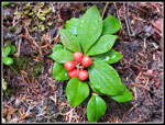
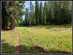
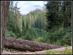
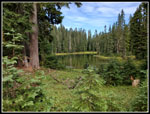
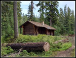
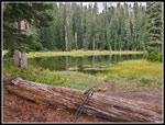
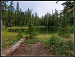
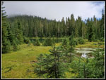
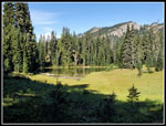
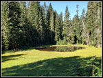
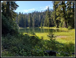
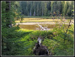
The trail reached about 4800' before dropping to the first two of the Three Lakes at 4650'. There are a couple meadows before the descent and we had a small sunbreak here. We arrived at the lakes at 11:49 am. The patrol cabin is right on the trail between the first two lakes. The lakes are quite close together. We went just beyond then turned around and decided to have lunch by the lakes. The cabin is in excellent shape. It has an old foundation but the rest looks recently refurbished. Around back a support piece has fallen off. A horizontal beam is hanging down. Does not look like it compromises the roof with a snow load but it needs repair. We followed a trail down to a point right between the lakes for our lunch. It was cool enough for a windshirt when sitting still. Most berries along the trail were still a bit sour but they were ripe here. Some bugs but not very annoying. A month ago this must have been much worse. This point was just before the 6 mile point with about 2700' of elevation gained. A good length for a day hike. We took a nice long lunch break.
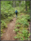
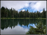
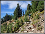
At 12:32 pm we packed up. We planned to head over to the third lake. We were feeling so good on the soft trail that we decided to go farther to see if we could get a view of Mount Rainier. The maps suggested about 1 mile to 1.25 miles steeply up to the Pacific Crest Trail. Reports we saw were not very exact as to where the views began. A fast short climb and drop brought us to the third lake. This one is just outside the national park. It is a little bigger. We had some sun shining on the water now. The trail leaves the lake and begins to climb. It is now narrower and less maintained than the trail in the park. Not bad just not as good. The trail passes another pond and some meadows then into more forest. Higher up we met a single backpacker coming down. She mentioned at the lake just above she saw a big herd of elk. We reached the lake to find no elk. The theme of the day. Our theme song could have been "Noel, No Elk". We were now 1.1 miles beyond the cabin and still in forest with no views. Turning around how would leave us with a 14 miles day. But still no view. We were feeling good so decided to continue.
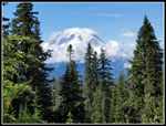
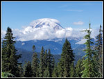
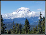
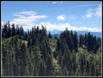
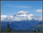
At about 7.5 miles we had a view of Mt. Rainier with some trees just partially blocking. There were big white clouds below the mountain and blue sky all around. We took some nice photos but we decided to go on to the pass. The terrain became more sub-alpine as we neared the 5700' highpoint. From the PCT junction we could see Mt. Adams and Mt. St. Helens. Rainier how had a cloud cap and more clouds below. Still, part of the mountain was in the clear. A pretty neat view with these conditions. Gary picked out Shriner Peak. I'm sure there were a lot more folks there this day. We had still only seen three people in 8 miles. We arrived at 1:50 pm. With breaks and lots of photos we took 5:21 to hike 8 miles. We had 5:40 until sunset then a long drive home. We took a shorter break and picked up the pace coming down. We left the PCT at 2:07 pm.
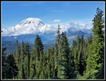
Where there were breaks in the forest we now had Mt. Rainier in front of us. The clouds kept building. Had we arrived later the view would have been more of clouds than mountain. We still stopped for some photos but concentrated on hiking. It turned out to be almost 2 miles from cabin to the PCT. There were still NoElk at the first lake coming down. We made it back to the cabin at 3:00 pm. Much faster than the ascent. During an 8 minute food and water break here we heard folks at one of the campsites. Did not see them but we did hear there. At 3:08 pm we started back and quickly headed up one of the two climbs we had on the way back. Gary decided to get it over fast and it was all I could do to keep up. Once up the hill we dropped to a quick but not that quick pace again. We soon met a group of five backpackers heading for the lake. More than all the folks seen prior. Still, three meetings with people over 16 miles is not bad at all.
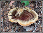
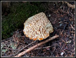
The rest of the way down was just 6 more miles of hiking. For the day we saw a very small assortment of wildflowers. Four asters, four cinquefoils, one pearly everlasting, and a few more. We did see a number of fresh mushrooms. Some were just popping out of the ground. The hard rain the day before may have helped. We stopped again at the big tree. After that, we just kept on descending. We had that last hill to climb. Only about 100' but still good to have it done. We were glad to finally see the highway come into view. We reached the car at 5:48 pm. 3:41 coming down was much faster than our ascent. We were out for more than 9 hours. The drive home was long but traffic was light. We were back at Gary's just before darkness. From there I drove home in the dark. That has not happened in a long while. Summer light is going away.
This turned out to be a better hike and trail than I was expecting. The clouds early really brought out the colors in the mossy forest. Up high the clouds gave way and we had views of three volcanoes. We were in Mt. Rainier NP for most of the hike and had tremendous solitude. That big tree was really big. We reached Three Lakes and saw several more small lakes and ponds. Getting up to 5700' on the Cascade Crest is always a treat. Maybe best of all was the soft tread that did not cause any foot pain even after 16 miles. This is a hike that I will return to in the not too distant future.
Click on thumbnails to get
larger pictures.
Trips - 2021
Home
The trail starts climbing immediately. It continues to climb most of the way. What it does not do is climb steeply. Just a steady grade of about 10% or a little less. Over miles that does add up. Lots of mossy ground in the first parts. Not a lot of underbrush. The most noticeable thing is the soft tread. This trail is easy on the feet. Most 10 mile hikes leave my feet sorer than 16 miles on this route. After a very rocky trip last Monday it was very much appreciated. The trail is sometimes near the creek but more often at a distance. The creek is mostly in a gorge below the trail. We saw only one side creek near a switchback that had any steady flow. Lots of bridges with dry rocks underneath. It was a cool 51 degrees when we started and never made it above the mid 60s. Two quarts of water was enough this day.
The trail climbs up a ridge then the grade eases. There are only two descents of even 100' all day. One drops down to near a pond at about 1.4 miles. It rained the day before but not much during the past few months. The pond was at a low level. As we hiked farther we began to see saprophytes. I saw a lot of them a month or so earlier. Many of these were past prime. Candystick was finished or at least the tops were but some red and white stripes remained lower down. When we reached the pine drops they were near peak. Some were nearly three feet tall. One patch had more than 20 of them. This trail would have been even more spectacular a month ago. The pine drops still were great.
Trees down low seemed pretty small to me. By the three mile point this changed markedly. Lots of big trees and some really big ones. Still mostly Douglas Fir at this elevation. We took a food and water break right before the 3.5 mile point. We noticed a tree 40' or so below the trail. Not obvious while hiking by but easy to see if you are looking. It is huge. I went down to it and Gary took some photos. My arm span is 6.5 feet. That did not cover one side. I would guess the circumference to be about 24 feet. We continued on gaining elevation continuously. At about 5 miles in we met a couple backpackers coming out. After the rain, they chose to head out from a trip up a section of the PCT. They mentioned seeing a herd of elk just ahead and below the trail. We heard some elk bugling. We did not see any elk. We did see one right along the highway on the drive in.
The trail reached about 4800' before dropping to the first two of the Three Lakes at 4650'. There are a couple meadows before the descent and we had a small sunbreak here. We arrived at the lakes at 11:49 am. The patrol cabin is right on the trail between the first two lakes. The lakes are quite close together. We went just beyond then turned around and decided to have lunch by the lakes. The cabin is in excellent shape. It has an old foundation but the rest looks recently refurbished. Around back a support piece has fallen off. A horizontal beam is hanging down. Does not look like it compromises the roof with a snow load but it needs repair. We followed a trail down to a point right between the lakes for our lunch. It was cool enough for a windshirt when sitting still. Most berries along the trail were still a bit sour but they were ripe here. Some bugs but not very annoying. A month ago this must have been much worse. This point was just before the 6 mile point with about 2700' of elevation gained. A good length for a day hike. We took a nice long lunch break.
At 12:32 pm we packed up. We planned to head over to the third lake. We were feeling so good on the soft trail that we decided to go farther to see if we could get a view of Mount Rainier. The maps suggested about 1 mile to 1.25 miles steeply up to the Pacific Crest Trail. Reports we saw were not very exact as to where the views began. A fast short climb and drop brought us to the third lake. This one is just outside the national park. It is a little bigger. We had some sun shining on the water now. The trail leaves the lake and begins to climb. It is now narrower and less maintained than the trail in the park. Not bad just not as good. The trail passes another pond and some meadows then into more forest. Higher up we met a single backpacker coming down. She mentioned at the lake just above she saw a big herd of elk. We reached the lake to find no elk. The theme of the day. Our theme song could have been "Noel, No Elk". We were now 1.1 miles beyond the cabin and still in forest with no views. Turning around how would leave us with a 14 miles day. But still no view. We were feeling good so decided to continue.
At about 7.5 miles we had a view of Mt. Rainier with some trees just partially blocking. There were big white clouds below the mountain and blue sky all around. We took some nice photos but we decided to go on to the pass. The terrain became more sub-alpine as we neared the 5700' highpoint. From the PCT junction we could see Mt. Adams and Mt. St. Helens. Rainier how had a cloud cap and more clouds below. Still, part of the mountain was in the clear. A pretty neat view with these conditions. Gary picked out Shriner Peak. I'm sure there were a lot more folks there this day. We had still only seen three people in 8 miles. We arrived at 1:50 pm. With breaks and lots of photos we took 5:21 to hike 8 miles. We had 5:40 until sunset then a long drive home. We took a shorter break and picked up the pace coming down. We left the PCT at 2:07 pm.
Where there were breaks in the forest we now had Mt. Rainier in front of us. The clouds kept building. Had we arrived later the view would have been more of clouds than mountain. We still stopped for some photos but concentrated on hiking. It turned out to be almost 2 miles from cabin to the PCT. There were still NoElk at the first lake coming down. We made it back to the cabin at 3:00 pm. Much faster than the ascent. During an 8 minute food and water break here we heard folks at one of the campsites. Did not see them but we did hear there. At 3:08 pm we started back and quickly headed up one of the two climbs we had on the way back. Gary decided to get it over fast and it was all I could do to keep up. Once up the hill we dropped to a quick but not that quick pace again. We soon met a group of five backpackers heading for the lake. More than all the folks seen prior. Still, three meetings with people over 16 miles is not bad at all.
The rest of the way down was just 6 more miles of hiking. For the day we saw a very small assortment of wildflowers. Four asters, four cinquefoils, one pearly everlasting, and a few more. We did see a number of fresh mushrooms. Some were just popping out of the ground. The hard rain the day before may have helped. We stopped again at the big tree. After that, we just kept on descending. We had that last hill to climb. Only about 100' but still good to have it done. We were glad to finally see the highway come into view. We reached the car at 5:48 pm. 3:41 coming down was much faster than our ascent. We were out for more than 9 hours. The drive home was long but traffic was light. We were back at Gary's just before darkness. From there I drove home in the dark. That has not happened in a long while. Summer light is going away.
This turned out to be a better hike and trail than I was expecting. The clouds early really brought out the colors in the mossy forest. Up high the clouds gave way and we had views of three volcanoes. We were in Mt. Rainier NP for most of the hike and had tremendous solitude. That big tree was really big. We reached Three Lakes and saw several more small lakes and ponds. Getting up to 5700' on the Cascade Crest is always a treat. Maybe best of all was the soft tread that did not cause any foot pain even after 16 miles. This is a hike that I will return to in the not too distant future.
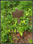 Trail Sign |
 Smooth Trail |
 Candystick |
 Neat Mushroom |
 More Smooth Trail |
 Gary On The Trail |
 Bunchberry Berries |
 Brushier Trail |
 Wet Leaves |
 Bent Tree |
 Wall Of Wood |
 Buckling Bridge |
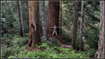 Tree Hugger Jim |
 Pine Drops |
 Meadow Along Trail |
 Another Mushroom |
 Lake & Clouds |
 First Lake |
 Patrol Cabin |
 Lunch Spot |
 Second Lake |
 Wet Red Leaves |
 Berry Picking |
 Leaving MRNP |
 Nearing Third Lake |
 Lake Reflection |
 Partial Mt. Rainier |
 Better Rainier |
 Cloudier |
 Shriner Peak |
 Almost To PCT |
 Mt. St. Helens |
 PCT Sign |
 Mt. Adams |
 Rainier From PCT |
 Fall Colors |
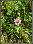 Aster |
 No Elk Pond |
 Meadow & Pond |
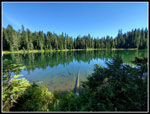 Lake 3 Reflection |
 Lake 1 Break |
 More Saprophytes |
 Red & White Berries |
 Last Pond/Lake |
 Nearing The End |
Trips - 2021
Home