4-18-21
Gary
and John were free for a
weekend hike. At first we were set for a hike up Ignoble Knob off
Highway 410. It became apparent that the unseasonably hot weather had a
avalanche warnings set for all aspects of all mountains. We decided to
look for a hike below snow level. With temperatures set to reach at or
near 80 degrees both days and the mountains dangerous lower elevation
trails were sure to be mobbed. Gary came up with a trip to a corner of
Chuckanut Mountain he had not yet hiked. I had done a trip to Pine and
Cedar Lakes but not to the Raptor Ridge or Madrone Crest. John had not
hiked these trails either. Having only seen the lakes in January of
2016 it would be nice to see them in spring too. We set an early
meeting at 8:00 am and hoped that the parking lot would not be full. I
was on the road by 6:36 am and was the first to arrive at 7:53 am. The
others arrived soon after. The roughly 300' elevation lot was mostly
full but had more than enough room for our cars.
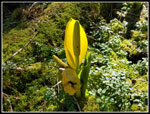
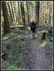
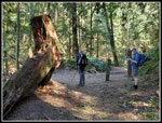
We packed up and were on the trail at 8:05 am. It was only 43 degrees at the start but warmed up quickly. I vaguely recalled a steep old road at the start. Yes, it is a very steep old road. We set a fast pace and it was challenging. We gained 1500' in the first 1.7 miles. Much of that was in the first .75 miles. We caught and passed one group. At the spot where the trail splits we went up the short very steep route and another group headed on the longer less steep alternative. After a bare lower level the trillium show began. Lots of trillium. Lots and lots of trillium. One of the best trillium hikes I have done. The other big flower show was skunk cabbage. At the lakes and in many more places along our route. At 1.5 miles we reached the first junction. A right turn heads west to Raptor Ridge and down to the north west side of the mountain. We would be hiking there a little later. Since we were ahead of much of the expected crowds we decided to see the lakes first.
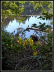
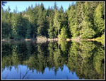
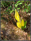
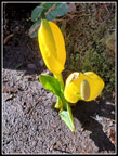
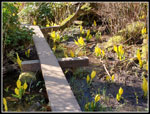
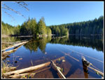
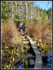
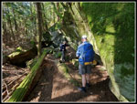
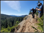
Just after the junction another junction turned off left and climbed to a viewpoint. The high point at 1800' would be the highest point we would reach all day. With only 1500' between the lowest and highest point we would manage to gain 3200' on the day. Lots of ups and downs. At the viewpoint we could see Mt. Baker though it was a bit hazy. Next we dropped down to Cedar Lake. We had a nice reflection in the lake as the wind was completely calm. Heading around the lake we came upon a group that was camping. At the end of the lake we followed a trail up to Pine Lake. As we reached a point above the lake we could hear folks. The trail drops down to lake level and then we went left on a narrow boardwalk over to the peninsula. We found two groups camping and another group fishing. After a quick stop and some photos we headed back on the boardwalk. All around the lake we saw a lot of skunk cabbage in bloom.
Back at the boardwalk junction we continued around the lake. This quickly brought us to the best skunk cabbage spot of the day. They were all around the boardwalk. Sunshine lit of the big yellow spathes. Quite a sight. We found another group camping and a spot on the shore of the lake for some more photos. Now it was back on the boardwalk and uphill again. We stopped at a spot with some screened views of the lake and had an early part of our lunchs. It was now about 9:45 am. We followed the main trail back to the spot where we had headed up to the viewpoint. It stayed well above Cedar Lake and made for a mostly level trail. We went past that junction to the junction leading towards the Raptor Ridge Viewpoint on the Hemlock Trail. This was trail none of us had hiked. After .60 miles we reached the next junction and turned left on the Raptor Ridge Trail. It was clear we were not going to be on the top of the ridge. We did see some very big rocks along the trail. In only .20 miles we found the short spur to the viewpoint.
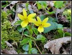
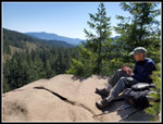
The viewpoint is a rock slab out of the forest. It allowed some views out. We could see parts of the mountain around us. The viewpoint of Baker we had seen earlier was higher blocked any views to the east. As luck would have it couple of hikers were there already. We took some photos and headed on. They along with most folks seen this day had masks on. The pandemic is not over though on our Cougar Mountain hike on Wednesday it seemed otherwise. Most folks no longer bothered to wear masks. Continuing on the Raptor Ridge Trail we quickly reached another junction. We debated and decided to do the next loop counterclockwise. We turned right on the Huckleberry Trail. An interesting name as we did not see a single huckleberry bush. We did see a lot more trillium and some yellow violets in bloom.
This one mile long trail seemed a lot longer to me. Though we were heading down it had a lot of short ups along the way. A nicely forested trail it is. It finally did start to lose some good elevation when we reached the next junction. We went left on the Salal Trail. This trail took us higher for .20 miles. Another junction put us on the Madrone Crest Trail. It should be obvious by now that a map is necessary for folks new to these trails. There are a lot of junctions. The signage is very good however. We had one more junction for the Madrone Crest. More trillium, skunk cabbage, and yellow violets along here. The trail came to an end on the ridge top. There are rocks to sit on and at one time there was a view of Mt. Baker. Now we could just make out a bit of it between branches of trees that have grown to block most of the views. This is probably not somewhere I will go again. We stopped for lunch and some more hikers arrived and stopped too.
We arrived at Madrone Crest at 11:44 pm. We stayed until 12:13 pm. We had hiked 6.7 miles and it was still just after noon. We headed back to the first junction and headed left and down to the North Lost Lake Trail. This is a trail I have hiked a number of times on a loop from the North Chuckanut Trailhead. Gay and John had hiked this too on one of the trips. We turned left and hiked this old road/trail .50 miles to the Raptor Ridge Trail. This trail would take us back up to the Raptor Ridge Viewpoint, closing a loop. Time for more ascending. The trail climbed in cool forest. We had several mountain bikes pass us heading down. The trail is quite narrow in places at it traverses a very steep slope. Our gps map listed Chuckanut Mountain at 1411' just off the trail. The trail goes around this bump at the end of a ridge. We decided to go for it.
We left the trail under the summit and headed up. Lots of down logs to over or around. John and I had shorts on and managed to scrape up our legs. We plowed ahead and reached a mossy flat rock at the highest point. Another summit. Completely in forest, it had no views at all. That bit of excitement out of the way we dropped to a saddle and decided to go over the other side. This cut out a bit of trail. The descent was not too bad. More skunk cabbage at the bottom. A short climb back up brought us to the trail.The route continued uphill to the junction with the Huckleberry Trail to close the loop. Now we were back on our morning route up to Raptor Ridge Viewpoint. Much to our surprise there was nobody at the viewpoint. Unlike our brief morning visit, we sat down for another break. We arrived at 1:30 pm and stayed until 1:46 pm. Sitting on the rock in the open it was now pretty warm out. Pleasantly warm. From here it would be almost all downhill to the trailhead. When two other hikers arrived we headed down.
It did not take long to get pack to the junction with the trail up from the trailhead. We saw folks off and on going down but not a whole lot of them. At the point where we had taken the straight up route rather than the longer one we took the longer trail going down. The map shows it as one traverse over then back. Actually it heads over then has a number of switchbacks as it descends. Once back on the main old road/trail we had the steepest part to go. We all thought it would be hard to descend but it was not as bad as we feared. In due course the cars came into view. The lot was mostly full with some open spots. Not too different that it was in the morning. We reached the cars at 2:55 pm.
For the day we hiked 11.5 mile with about 3200' of gain. As mentioned earlier it is rare to gain more than twice the elevation from the low to high point. This day we did. We saw two lakes, two viewpoints, and one forested off trail summit. We saw quite a few people but had long periods of solitude. Over the 6:50 minutes we were out the number of folks seen was not very high. You would have seen more in half an hour on the Oyster Dome Trail nearby. It is always fun to hike new trails and all of us did so this day. That said when the avalanche danger drops I will be ready to do some snow travel in the mountains and get away from the Puget Sound lowlands once again.
Click on thumbnails to get
larger pictures.
Trips - 2021
Home
We packed up and were on the trail at 8:05 am. It was only 43 degrees at the start but warmed up quickly. I vaguely recalled a steep old road at the start. Yes, it is a very steep old road. We set a fast pace and it was challenging. We gained 1500' in the first 1.7 miles. Much of that was in the first .75 miles. We caught and passed one group. At the spot where the trail splits we went up the short very steep route and another group headed on the longer less steep alternative. After a bare lower level the trillium show began. Lots of trillium. Lots and lots of trillium. One of the best trillium hikes I have done. The other big flower show was skunk cabbage. At the lakes and in many more places along our route. At 1.5 miles we reached the first junction. A right turn heads west to Raptor Ridge and down to the north west side of the mountain. We would be hiking there a little later. Since we were ahead of much of the expected crowds we decided to see the lakes first.
Just after the junction another junction turned off left and climbed to a viewpoint. The high point at 1800' would be the highest point we would reach all day. With only 1500' between the lowest and highest point we would manage to gain 3200' on the day. Lots of ups and downs. At the viewpoint we could see Mt. Baker though it was a bit hazy. Next we dropped down to Cedar Lake. We had a nice reflection in the lake as the wind was completely calm. Heading around the lake we came upon a group that was camping. At the end of the lake we followed a trail up to Pine Lake. As we reached a point above the lake we could hear folks. The trail drops down to lake level and then we went left on a narrow boardwalk over to the peninsula. We found two groups camping and another group fishing. After a quick stop and some photos we headed back on the boardwalk. All around the lake we saw a lot of skunk cabbage in bloom.
Back at the boardwalk junction we continued around the lake. This quickly brought us to the best skunk cabbage spot of the day. They were all around the boardwalk. Sunshine lit of the big yellow spathes. Quite a sight. We found another group camping and a spot on the shore of the lake for some more photos. Now it was back on the boardwalk and uphill again. We stopped at a spot with some screened views of the lake and had an early part of our lunchs. It was now about 9:45 am. We followed the main trail back to the spot where we had headed up to the viewpoint. It stayed well above Cedar Lake and made for a mostly level trail. We went past that junction to the junction leading towards the Raptor Ridge Viewpoint on the Hemlock Trail. This was trail none of us had hiked. After .60 miles we reached the next junction and turned left on the Raptor Ridge Trail. It was clear we were not going to be on the top of the ridge. We did see some very big rocks along the trail. In only .20 miles we found the short spur to the viewpoint.
The viewpoint is a rock slab out of the forest. It allowed some views out. We could see parts of the mountain around us. The viewpoint of Baker we had seen earlier was higher blocked any views to the east. As luck would have it couple of hikers were there already. We took some photos and headed on. They along with most folks seen this day had masks on. The pandemic is not over though on our Cougar Mountain hike on Wednesday it seemed otherwise. Most folks no longer bothered to wear masks. Continuing on the Raptor Ridge Trail we quickly reached another junction. We debated and decided to do the next loop counterclockwise. We turned right on the Huckleberry Trail. An interesting name as we did not see a single huckleberry bush. We did see a lot more trillium and some yellow violets in bloom.
This one mile long trail seemed a lot longer to me. Though we were heading down it had a lot of short ups along the way. A nicely forested trail it is. It finally did start to lose some good elevation when we reached the next junction. We went left on the Salal Trail. This trail took us higher for .20 miles. Another junction put us on the Madrone Crest Trail. It should be obvious by now that a map is necessary for folks new to these trails. There are a lot of junctions. The signage is very good however. We had one more junction for the Madrone Crest. More trillium, skunk cabbage, and yellow violets along here. The trail came to an end on the ridge top. There are rocks to sit on and at one time there was a view of Mt. Baker. Now we could just make out a bit of it between branches of trees that have grown to block most of the views. This is probably not somewhere I will go again. We stopped for lunch and some more hikers arrived and stopped too.
We arrived at Madrone Crest at 11:44 pm. We stayed until 12:13 pm. We had hiked 6.7 miles and it was still just after noon. We headed back to the first junction and headed left and down to the North Lost Lake Trail. This is a trail I have hiked a number of times on a loop from the North Chuckanut Trailhead. Gay and John had hiked this too on one of the trips. We turned left and hiked this old road/trail .50 miles to the Raptor Ridge Trail. This trail would take us back up to the Raptor Ridge Viewpoint, closing a loop. Time for more ascending. The trail climbed in cool forest. We had several mountain bikes pass us heading down. The trail is quite narrow in places at it traverses a very steep slope. Our gps map listed Chuckanut Mountain at 1411' just off the trail. The trail goes around this bump at the end of a ridge. We decided to go for it.
We left the trail under the summit and headed up. Lots of down logs to over or around. John and I had shorts on and managed to scrape up our legs. We plowed ahead and reached a mossy flat rock at the highest point. Another summit. Completely in forest, it had no views at all. That bit of excitement out of the way we dropped to a saddle and decided to go over the other side. This cut out a bit of trail. The descent was not too bad. More skunk cabbage at the bottom. A short climb back up brought us to the trail.The route continued uphill to the junction with the Huckleberry Trail to close the loop. Now we were back on our morning route up to Raptor Ridge Viewpoint. Much to our surprise there was nobody at the viewpoint. Unlike our brief morning visit, we sat down for another break. We arrived at 1:30 pm and stayed until 1:46 pm. Sitting on the rock in the open it was now pretty warm out. Pleasantly warm. From here it would be almost all downhill to the trailhead. When two other hikers arrived we headed down.
It did not take long to get pack to the junction with the trail up from the trailhead. We saw folks off and on going down but not a whole lot of them. At the point where we had taken the straight up route rather than the longer one we took the longer trail going down. The map shows it as one traverse over then back. Actually it heads over then has a number of switchbacks as it descends. Once back on the main old road/trail we had the steepest part to go. We all thought it would be hard to descend but it was not as bad as we feared. In due course the cars came into view. The lot was mostly full with some open spots. Not too different that it was in the morning. We reached the cars at 2:55 pm.
For the day we hiked 11.5 mile with about 3200' of gain. As mentioned earlier it is rare to gain more than twice the elevation from the low to high point. This day we did. We saw two lakes, two viewpoints, and one forested off trail summit. We saw quite a few people but had long periods of solitude. Over the 6:50 minutes we were out the number of folks seen was not very high. You would have seen more in half an hour on the Oyster Dome Trail nearby. It is always fun to hike new trails and all of us did so this day. That said when the avalanche danger drops I will be ready to do some snow travel in the mountains and get away from the Puget Sound lowlands once again.
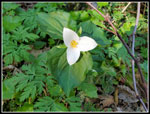 Trillium |
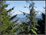
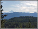 Mt. Baker |
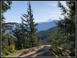 Viewpoint & Baker |
 First Skunk Cabbage |
 Cedar Lake & Cabbage |
 Cedar Lake Reflection |
 More Skunk Cabbage |
 Nicely Lit Up |
 Skunk Cabbage Bonanza |
 Pine Lake |
 Even More |
 Walking The Plank |
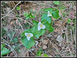 Trillium Trio |
 Big Rocks |
 Big Mossy Rock |
 Knotty Tree |
 Raptor Ridge Viewpoint |
 Back On Trail |
 Neat Contrast |
 Twin Yellow Violets |
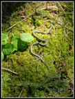 Garter Snake |
 Madrone Crest Viewpoint |
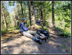 Lunch Time |
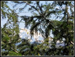 Mt. Baker Behind Trees |
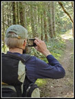 Gary's Photo |
 Sunshine On Trail! |
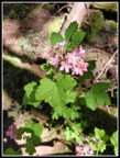 Red Currant |
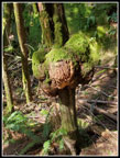
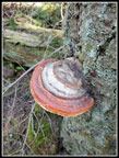 Colorful Fungus |
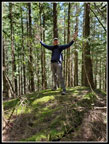 Gary Atop Chuckanut Mt. |
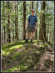 John On Chuckanut Mt. |
 Back At Raptor Ridge |
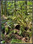 Hanging Moss |
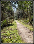
 At Lakes Trail |
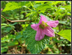 Salmonberry Flower |
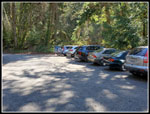 Parking Lot |
Trips - 2021
Home