05-22-22
Gary
was free for a Sunday hike. I
had hiked 8 miles with 1700' of gain on Saturday. I wanted an easier
trip. The weather would be excellent so all areas were up for grabs.
Gary hiked the Diablo Lake Trail some years earlier. He told me about
it and I hiked it with Kim. We really enjoyed it. Gary had hiked it
several more times. We had not hiked it together. Diablo Lake it would
be. It is a long drive so I was up at 5:00 am and out the door at 6:05
am. We met in Lynnwood at 6:25 and headed north. Traffic was very light
at that hour. Part of Highway 20 between Marblemount and Newhalem has
one lane severely damaged. There are traffic lights at each end. We
had no problem in the morning. We crossed Diablo Dam and
reached the parking lot at 8:22 am. We were packed and on our way at
8:29 am.
It was a bit chilly at first but not really cold. We were looking forward to the high 60s in the afternoon. We did not see any trip reports this year. We were pretty certain it would be snow free and hoped that there would not be many down trees over the trail. The trail starts by going around the North Cascades Environmental Learning Center. There were a number of cars in the lot. Most had dew on the windshields so we figured they were staying at the center and probably would not be on the trail. That proved to be true. We navigated several junctions before settling on the Diablo Lake Trail. There were a few streams to rock hop in the first half mile. I did not do so well here. The widest one had a rock a log and another rock to hop. Well, I made it over th first two. I slipped off the third and fell into the water. I can attest that my cell phone is waterproof. My pants not so much. I was not planning a brisk refreshing time laying in a creek. I had no cotton on and everything did dry out. The only time I did that before was when a pole collapsed.
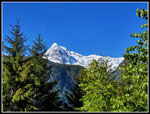
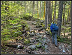
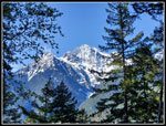
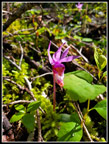
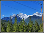
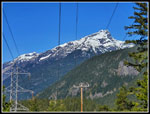
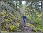
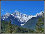
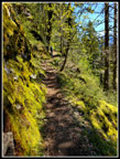
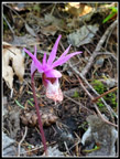
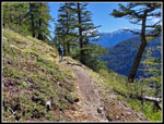
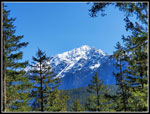
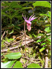
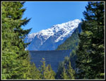
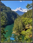
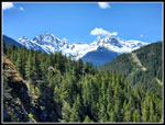
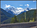
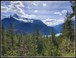
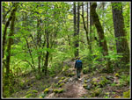
There are several spots where lots of water runs down the hillside carrying rocks along with it. Boots have beaten in paths across them. One wide one had no tracks and looks to be pretty new. Other than that, the tread is good. Mostly smooth with soft duff much of the way. The route climbs up about 800', levels off, and then drops about 800' to the suspension bridge at the base of Ross Dam. The climb is longer and gentler than the descent. In the first mile we saw deer near the trail. We were to see an interesting assortment of wildlife this day. About 1.5 miles in Gary noticed some color. Tiny calypso orchids dotted the side of the trail. They are small but very colorful. It is not usual to see them. I often do see them a time or two in the spring. At 1.7 miles we took a short detour to a powerline corridor with great views of the Colonial-Pyramid Peaks group. We were early enough to have it to ourselves.
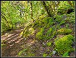
Late snowfall combined with a very cold spring has left the peaks with a solid coat of bright white snow. Add the blue sky and it makes for unusually good peak photos in late May. Even with the powerlines in view, the mountain views are terrific. We could also see a bit of Diablo Lake. We arrived at 9:17 am and stayed until 9:35 am. That was our one stop on the way in. We did slow down a lot when the flower show began. It has been a fairly wet and cloudy spring and all the mossy rocks along the trail were especially colorful with water running down the moss in many places.
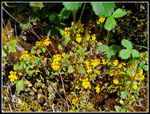
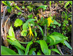
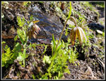
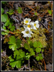
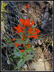
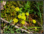
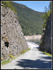
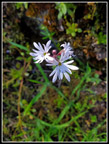
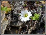
The trail crosses very steep slopes with big drop offs on the right and some near vertical cliffs on the left. We first saw big patches of tiny yellow flowers growing on moss along the rock walls. Soon after that, Gary noticed chocolate lilies. I seldom see than as their color is nearly identical to the hillside. Once we saw one we began to see many more. There were quite a few over a distance on the hillside. Strawberries were also in bloom. Then the calypso show started up. I have never seen anything close to the next couple miles of the trail. Calypso orchids everywhere. Clumps of 6-8 here and 3 or 4 there. Hundreds of them. They are tiny and do not dominate the hillside but do provide really bright colors. There were some Indian paintbrush in bloom. Two varieties of reddish orange. I looked for the tiny stonecrop plants. No flowers yet but the many shades of green on the rubber like plants was a neat sight. A few glacier lilies were still hanging on. I did not recognize a couple small white and blue flowers. One yellow flower looked to be some variety of parsley.
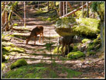
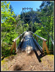
As mentioned, the wildflower show slowed us down considerably. I was a little surprised that nobody caught up with us. Just before the descent began, we met the first person of the day. He was coming back. He mentioned that there seemed to be fewer calypso orchids than usual. If several hundred is a bad year, what does a good one look like? The descent is steeper than the ascent but the trail remains smooth. Few stops, rocks, or roots to deal with. There are three rock hop creeks. I was pleased to remain vertical after all of them. By now I was mostly dry again. There were logs down over the trail but we could step over all of them. The steep flower slopes were mostly in the open. The descent was in forest. I was looking forward to getting out in the sunshine again. We reached the bottom and the suspension bridge when Gary stopped. There were two deer just ahead. We took some photos and the deer did not seem to care about us. In fact, they walked closer. There was a third one we saw about now. That made it 5 deer on the way in. Not bad.
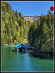
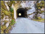
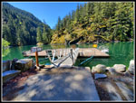
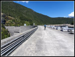
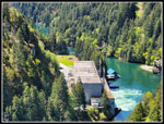
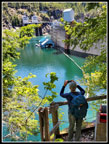
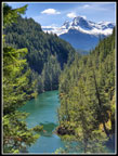
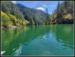
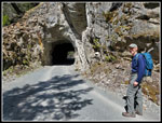
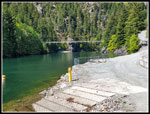
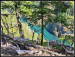
We crossed the bridge walking back into bright sunshine. It was 10:51 am. After 2:22 we had hiked just under 4 miles. The GPS recorded a moving average of 2.6 mph. The long mountain view break and photo stops slowed it to under 2 mph total time. We followed the road down the lake/river. The power plant was right there. The dam was not in sight but it was from the bridge. The road leads to a tunnel and continues up to the dam. We took a detour to the floating dock where the tour boats land in season. There is an outhouse there too. The lake water is very green. A waterfall is above. The waterfall creek is spanned by a bridge on Highway 20. We were in wilderness with a major highway right above us. The sun felt great and we just sat and had part of our lunch. We arrived at 11:10 am and stayed until 11:49. We had both been this far. Now it was time to continue on.
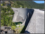
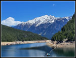
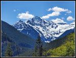
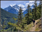
The road climbs to the dam in about a mile from the suspension bridge. Up we went. We had a few views out to the Colonial Peaks along the way. The narrow river/lake was below. Both of us had been to the dam from the parking lot off Highway 20. Neither of us had been up this road. We met the junction where the road goes to the east side of the lake and the trail up to the parking lot off the highway. Some folks we saw later just hiked downhill a half mile to the dam. On the dam, the first thing we saw was how low the lake is. There is a lot of snow still to melt. The Colonial-Pyramid Peaks were resplendent in their white coats of snow. As we walked across the dam, 9075' Jack Mountain came into view. It too had a lot of snow on it. There is quite a view from the dam right now. We had planned to turn around at the end of the dam and have a 10 mile hike. We felt good and decided to continue a while on the Ross Dam Trail. The trail is not level. We had a number of ups and downs. Part way along we met a Mountaineer Backpacking group. They spent the night at Big Beaver Creek. The leader was Louise, who I know. I have also hiked with Heidi in the group. You never know who you will meet on the trail.
We saw a few more people on this trail. After only seeing one person on the way to the dam this seemed like a crowd. When we were right above the floating resort buildings we headed back. We saw them from the dam but not from the forested trail. Back at the dam, we stopped to put on sunscreen. We have not seen much sun so far this year. We hiked back to the dock for another long break. We did have a long drive back and the broken Highway 20 and Puget Sound traffic would make for slower trip back. We reached the dock at 1:59 pm. We stayed until 2:28 pm. It was now getting hot on the dock. I noticed a crazy reflection on the box of the one boat tied to the dock. It looked like it was on fire. I took a video of it. When we did leave Gary picked up a hitchhiker. A butterfly landed on him and decided to stay. I took photos of it. We were entertained enough that when we sent it on its way it was now 2:42 pm.
We hiked back to the bridge and across. We left just ahead of another group of younger hikers. They closed the gap then stopped and we powered up the trail. As mentioned the trail is moderately steep but smoothly graded. It was also in the shade. We decided to just set a faster pace to get it out of the way. The trail leveled off somewhat where the open flower slopes are. We took a few photos but mostly just kept moving. At the powerline viewpoint, we took a last food and water break. As expected, there were other folks here now. As we left the younger hikers arrived. They did not stay long and they ended up passing us in the last mile. Younger knees went downhill faster than ours. I was pleased to safely get across the creek I had laid in earlier. We arrived at the parking lot at 4:30 pm We also went down to the shore of Diablo Lake for a view of the lake and the peaks behind it.
On the drive home, we found that the traffic light seemed to allocate the same amount of time for each direction. Unfortunately, we stopped over a mile before the light. There was no backup in the other direction. Eight cars went through with our group. Zero to three cars went through in the other direction. To be efficient we should have had about four times as long with a green light. This may be a real mess on Memorial Day weekend. The rest of the drive home was fine. After losing 30 minutes to the light we were late enough to miss the Marysville backup on I-5.
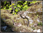
For the weekend I did 2 hikes totaling 20 miles with 4600' of elevation gain. The Diablo trip was 12+ miles with 2900' of gain. We saw one person on the way to the dam. We saw 5 deer. On the Ross Dam Trail, we saw a big garter snake sunning itself. The crazy butterfly entertained us as well. The last time I was at the dam was about 30 years ago. The wildflower show was not prolific but there was a good variety and the calypso orchids were a real treat. This was a great hiking weekend. My second time on the Diablo Lake Trail was great again and this time I went even farther. It was a sunny and great weekend on the trails.
Click on thumbnails to get
larger pictures.
Trips - 2022
Home
It was a bit chilly at first but not really cold. We were looking forward to the high 60s in the afternoon. We did not see any trip reports this year. We were pretty certain it would be snow free and hoped that there would not be many down trees over the trail. The trail starts by going around the North Cascades Environmental Learning Center. There were a number of cars in the lot. Most had dew on the windshields so we figured they were staying at the center and probably would not be on the trail. That proved to be true. We navigated several junctions before settling on the Diablo Lake Trail. There were a few streams to rock hop in the first half mile. I did not do so well here. The widest one had a rock a log and another rock to hop. Well, I made it over th first two. I slipped off the third and fell into the water. I can attest that my cell phone is waterproof. My pants not so much. I was not planning a brisk refreshing time laying in a creek. I had no cotton on and everything did dry out. The only time I did that before was when a pole collapsed.
There are several spots where lots of water runs down the hillside carrying rocks along with it. Boots have beaten in paths across them. One wide one had no tracks and looks to be pretty new. Other than that, the tread is good. Mostly smooth with soft duff much of the way. The route climbs up about 800', levels off, and then drops about 800' to the suspension bridge at the base of Ross Dam. The climb is longer and gentler than the descent. In the first mile we saw deer near the trail. We were to see an interesting assortment of wildlife this day. About 1.5 miles in Gary noticed some color. Tiny calypso orchids dotted the side of the trail. They are small but very colorful. It is not usual to see them. I often do see them a time or two in the spring. At 1.7 miles we took a short detour to a powerline corridor with great views of the Colonial-Pyramid Peaks group. We were early enough to have it to ourselves.
Late snowfall combined with a very cold spring has left the peaks with a solid coat of bright white snow. Add the blue sky and it makes for unusually good peak photos in late May. Even with the powerlines in view, the mountain views are terrific. We could also see a bit of Diablo Lake. We arrived at 9:17 am and stayed until 9:35 am. That was our one stop on the way in. We did slow down a lot when the flower show began. It has been a fairly wet and cloudy spring and all the mossy rocks along the trail were especially colorful with water running down the moss in many places.
The trail crosses very steep slopes with big drop offs on the right and some near vertical cliffs on the left. We first saw big patches of tiny yellow flowers growing on moss along the rock walls. Soon after that, Gary noticed chocolate lilies. I seldom see than as their color is nearly identical to the hillside. Once we saw one we began to see many more. There were quite a few over a distance on the hillside. Strawberries were also in bloom. Then the calypso show started up. I have never seen anything close to the next couple miles of the trail. Calypso orchids everywhere. Clumps of 6-8 here and 3 or 4 there. Hundreds of them. They are tiny and do not dominate the hillside but do provide really bright colors. There were some Indian paintbrush in bloom. Two varieties of reddish orange. I looked for the tiny stonecrop plants. No flowers yet but the many shades of green on the rubber like plants was a neat sight. A few glacier lilies were still hanging on. I did not recognize a couple small white and blue flowers. One yellow flower looked to be some variety of parsley.
As mentioned, the wildflower show slowed us down considerably. I was a little surprised that nobody caught up with us. Just before the descent began, we met the first person of the day. He was coming back. He mentioned that there seemed to be fewer calypso orchids than usual. If several hundred is a bad year, what does a good one look like? The descent is steeper than the ascent but the trail remains smooth. Few stops, rocks, or roots to deal with. There are three rock hop creeks. I was pleased to remain vertical after all of them. By now I was mostly dry again. There were logs down over the trail but we could step over all of them. The steep flower slopes were mostly in the open. The descent was in forest. I was looking forward to getting out in the sunshine again. We reached the bottom and the suspension bridge when Gary stopped. There were two deer just ahead. We took some photos and the deer did not seem to care about us. In fact, they walked closer. There was a third one we saw about now. That made it 5 deer on the way in. Not bad.
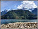
We crossed the bridge walking back into bright sunshine. It was 10:51 am. After 2:22 we had hiked just under 4 miles. The GPS recorded a moving average of 2.6 mph. The long mountain view break and photo stops slowed it to under 2 mph total time. We followed the road down the lake/river. The power plant was right there. The dam was not in sight but it was from the bridge. The road leads to a tunnel and continues up to the dam. We took a detour to the floating dock where the tour boats land in season. There is an outhouse there too. The lake water is very green. A waterfall is above. The waterfall creek is spanned by a bridge on Highway 20. We were in wilderness with a major highway right above us. The sun felt great and we just sat and had part of our lunch. We arrived at 11:10 am and stayed until 11:49. We had both been this far. Now it was time to continue on.
The road climbs to the dam in about a mile from the suspension bridge. Up we went. We had a few views out to the Colonial Peaks along the way. The narrow river/lake was below. Both of us had been to the dam from the parking lot off Highway 20. Neither of us had been up this road. We met the junction where the road goes to the east side of the lake and the trail up to the parking lot off the highway. Some folks we saw later just hiked downhill a half mile to the dam. On the dam, the first thing we saw was how low the lake is. There is a lot of snow still to melt. The Colonial-Pyramid Peaks were resplendent in their white coats of snow. As we walked across the dam, 9075' Jack Mountain came into view. It too had a lot of snow on it. There is quite a view from the dam right now. We had planned to turn around at the end of the dam and have a 10 mile hike. We felt good and decided to continue a while on the Ross Dam Trail. The trail is not level. We had a number of ups and downs. Part way along we met a Mountaineer Backpacking group. They spent the night at Big Beaver Creek. The leader was Louise, who I know. I have also hiked with Heidi in the group. You never know who you will meet on the trail.
We saw a few more people on this trail. After only seeing one person on the way to the dam this seemed like a crowd. When we were right above the floating resort buildings we headed back. We saw them from the dam but not from the forested trail. Back at the dam, we stopped to put on sunscreen. We have not seen much sun so far this year. We hiked back to the dock for another long break. We did have a long drive back and the broken Highway 20 and Puget Sound traffic would make for slower trip back. We reached the dock at 1:59 pm. We stayed until 2:28 pm. It was now getting hot on the dock. I noticed a crazy reflection on the box of the one boat tied to the dock. It looked like it was on fire. I took a video of it. When we did leave Gary picked up a hitchhiker. A butterfly landed on him and decided to stay. I took photos of it. We were entertained enough that when we sent it on its way it was now 2:42 pm.
We hiked back to the bridge and across. We left just ahead of another group of younger hikers. They closed the gap then stopped and we powered up the trail. As mentioned the trail is moderately steep but smoothly graded. It was also in the shade. We decided to just set a faster pace to get it out of the way. The trail leveled off somewhat where the open flower slopes are. We took a few photos but mostly just kept moving. At the powerline viewpoint, we took a last food and water break. As expected, there were other folks here now. As we left the younger hikers arrived. They did not stay long and they ended up passing us in the last mile. Younger knees went downhill faster than ours. I was pleased to safely get across the creek I had laid in earlier. We arrived at the parking lot at 4:30 pm We also went down to the shore of Diablo Lake for a view of the lake and the peaks behind it.
On the drive home, we found that the traffic light seemed to allocate the same amount of time for each direction. Unfortunately, we stopped over a mile before the light. There was no backup in the other direction. Eight cars went through with our group. Zero to three cars went through in the other direction. To be efficient we should have had about four times as long with a green light. This may be a real mess on Memorial Day weekend. The rest of the drive home was fine. After losing 30 minutes to the light we were late enough to miss the Marysville backup on I-5.
For the weekend I did 2 hikes totaling 20 miles with 4600' of elevation gain. The Diablo trip was 12+ miles with 2900' of gain. We saw one person on the way to the dam. We saw 5 deer. On the Ross Dam Trail, we saw a big garter snake sunning itself. The crazy butterfly entertained us as well. The last time I was at the dam was about 30 years ago. The wildflower show was not prolific but there was a good variety and the calypso orchids were a real treat. This was a great hiking weekend. My second time on the Diablo Lake Trail was great again and this time I went even farther. It was a sunny and great weekend on the trails.
 First Peak View |
 Rocky Trail. |
 Mossy Rocks |
 View Through Trees |
 First Calypso Orchid |
 Powerline Viewpoint |
 Davis Peak |
 Gary At Talus Field |
 Colonial Peak |
 Seep Monkey Flower |
 Mossy Wall |
 Another Calypso |
 More Greenery |
 Indian Paintbrush |
 Yellow Flower |
 Glacier Lilies |
 Chocolate Lilies |
 White Flowers |
 Different Paintbrush |
 Partial View Of Jack Mt |
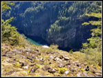 Lake Far Below |
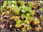 Stonecrop |
 Parsley |
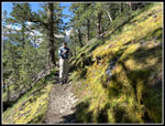 Jim On Trail |
 Jack Mountain |
 One More Calypso |
 Dam & Jack Mt |
 Deer Friends |
 Suspension Bridge |
 Green Water |
 Into The Tunnel |
 Floating Dock |
 Lake & Peaks |
 Onto The Dam |
 Ross Dam |
 Gary On Dam |
 Peaks From Dam |
 Powerhouse |
 Lake & Jack Mt |
 Big Garter Snake |
 Gary & Low Lake |
 Colonial Pk From Dam |
 Colonial-Pyramid Group |
 Kayak On Lake |
 Back At Dock |
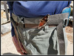 Butterfly On Gary |
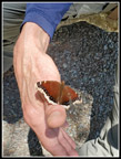 Butterfly Close Up |
 At Tunnel Again |
 Nearing Bridge |
 Woodland Star |
 Boat Far Below |
 Gary With Peaks |
 Another White Flower |
 Some Clouds |
 Bright New Leaves |
 Lake At Trailhead |
Trips - 2022
Home