03-27-22
I
needed to be home by early
afternoon so it was time for another close in hike. I chose a trip on
easy smooth trails without big crowds. I have had good luck hiking up
the Master Link and Quick Link trails early in the morning. They are
popular with mountain bikers but I usually get up East Tiger before
most of them arrive. This day I arrived at the inner parking lot at
Tiger Summit at 7;47 am. By 7:52 am I was on my way. The lot was a
little less than half full. I saw two hikers getting ready to go. I
never saw them again. It was cool enough for gloves at first though it
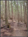
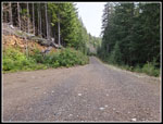
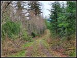
warmed up nicely through the morning. I hiked the Connector Trail to
the main road and across onto the Northwest Timber Trail. I would be
back on this trail a few hours later. I quickly left it to begin
climbing on the Master Link Trail. The grade is food for bikers but
pretty gentle for a hiking trail. Just the thing if you want to hike
fast.
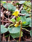
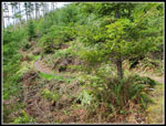
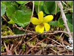
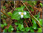
I was in a mile and a half when I saw the first people. One bike was upside down and several folks were working on it. I don't usually pass bikes. A few minutes later two bikers went by me. I kept an eye out for wildflowers. I was rewarded with just a couple yellow violets that were beginning to open. Not much but it was a start to wildflower season. At the Inside Passage Trail junction I saw two more bikers. That was it until just before the main upper road. They passed me within a minute of reaching the road. I stopped a couple minutes before that when I saw one yellow skunk cabbage down below the trail. I had to go over to take a look. I saw two stationary bike groups and was passed by two others over 3.0 miles in 1:01. The 3 mph average uphill was very good for me. The smooth gentle trail really helped.
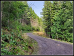
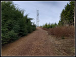
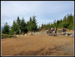
The bikers headed up the road and I crossed over onto the Quick Link Trail. This smooth gentle trail is longer than the road but much less steep. It soon brought me back to the road. Now It was just a road walk tot he top of East Tiger Mountain. Up to the high point at the Predator Trail, down to the junction with the summit spur road, and then .70 miles uphill to the summit. Two more bikers passed me near the bottom of the summit spur. I noticed a little snow in the ditch along the trail near the top. That was the only snow seen all day. I reached 3000' the top at 9:23 am. I had hiked 4.25 miles in 1:30 averaging 2.8 mph. There were several different bike groups on top. On the summit spur I did see a group of three hikers coming down. They were the only non bikers I saw until the last mile of the day.
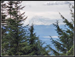
Part of Mt. Rainier was visible, part was in the clouds. There was low fog in places. It was pretty clear on top. It was a lot clearer than on my last visit here three weeks earlier. I only spent 3 minutes for some water and photos and I was on my way down. I hiked down the road passing the East Tiger Trail. The East Tiger and Off the Grid is a forested trail route to where I was going via the road. It is longer and does have some speedy bikes on it. Sometimes I hike it. This day I went for the more direct road route. When the road reached the top of the Quick Link I passed on by. I saw nobody on the QL coming up. Later in the morning it gets pretty crowded. When I reached the where the Master Link and Quick Link meet on the road there were a whole lot of bikers. I think it was 6-8 of them. They blocked almost the entire 20'wide road. If you are going to hike the Master Link on a weekend it pays to be early.
I saw one more biker coming up the road. He mentioned seeing me earlier. I stayed on the steeply descending road until I reached where the Off The Grid Trail comes in on the left and the Fully Rigid Trail descends to the right. There was another biker here at the picnic table. It was rapidly turning into a warm spring day. I had my sleeves rolled up. I almost zipped off my pants legs. If it was not downhill I probably would have. Not bad after starting out with gloves on. This bike trail has some jumps and a few muddy spots. It is not smooth like the ML and QL Trails. I only saw a couple bikers on this and the Joy Ride Trail down the Northwest Timber Trail.
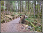
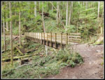
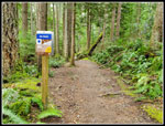
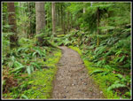
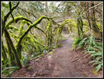
There is a junction for a short side trail to an old road that parallels the trail at one spot. I have seen the route on the map but had never hiked it. Time for a new trail section. The trail is narrow with some jumps as mentioned above. The old road is wide with oft grass in the middle. It is softer and easier walking than the bike trail. It is also out in the open instead of in forest I liked being out in the sunshine. The Joy Ride Trail soon crosses the old road. I turned right back onto the trail. In just a few minutes I reached the Northwest Timber Trail. This bike trail runs parallel to Highway 18 back to Tiger Summit. The second half if it is close enough to hear the traffic. It is mostly a very gentle uphill grade. Very gentle. There are 4 or 5 good sized bridges over creeks. No two bridges are alike. Different designs and or handrails.
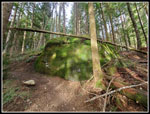
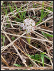
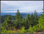
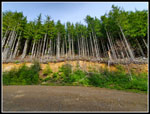
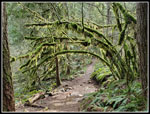
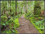
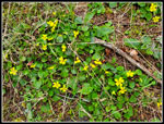
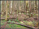
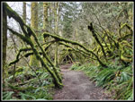
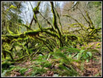
Most of the trail is in forest. There is a clear cut in the middle that provides views out to Rattlesnake Mountain. It also provides a lot of sunshine. I have noticed that wildflowers bloom earlier here than other places on Tiger Mountain. That was one reason for my route this day. I was not disappointed. At first I saw a few small clumps of yellow violets in bloom. Also, some dandelions. The small clumps became big ones. A few must have had 50 or more violets. Easily the best display I have seen this year. Other flowers like salmonberry have not even began to bloom yet. There are also several really impressive mossy arches along this trail. The biggest one lost a number of trees in a storm several years ago but there are plenty left. By now the trail seems to be endless. The long straight NW Timber Trail just goes on and on. On this and on every trip I have done on it. I was fortunate to just notice the one and only blooming trillium I saw on the trip.
When I was about 9 mile along with just a mile to go I passed two separate couples hiking out on the trail. I looked for and saw the striped trees on the right side. I have no idea why they have white stripes painted on them. I was glad to close my loop back at the bottom of the Master Link Trail. I saw half a dozen bikes starting up it. I quickly reached the road and crossed if for the last .30 miles on the Connector Trail. I reached the parking lot at 11:31 am. It was jam packed. I reached my car at exactly 10.0 miles. It was a bit of a fluke to hit it right on the nose. For the day I hiked 10 miles with 1900' of gain in 3:39. I averaged 2.75 mph. I took a lot more photos coming down. That slowed me a bit. I was pleased to get in a 10 mile day and be done just after 11:30 am. I was easily home by 12:30 pm.
This trip gave me just what I was looking for. A short drive and a double digit mileage hike. I was home early. I was early enough to see few folks going up. I came down a route that is seldom crowded. I had some views from East Tiger, some sunshine on the road walk and NW Timber clearcut, and quite a bit of solitude. I was disappointed on my drive out of the parking lot. Not only was the lot full but there were about 30 cars parked along the dirt road. It is a two lane road. This day it was a one lane road. I met a car coming in and I had to squeeze into the one and only pull out so we could pass. This is the first time I have seen folks parking on the road. It was a bit disappointing. The rest of the day was anything but.
Click on thumbnails to get
larger pictures.
Trips - 2022
Home
I was in a mile and a half when I saw the first people. One bike was upside down and several folks were working on it. I don't usually pass bikes. A few minutes later two bikers went by me. I kept an eye out for wildflowers. I was rewarded with just a couple yellow violets that were beginning to open. Not much but it was a start to wildflower season. At the Inside Passage Trail junction I saw two more bikers. That was it until just before the main upper road. They passed me within a minute of reaching the road. I stopped a couple minutes before that when I saw one yellow skunk cabbage down below the trail. I had to go over to take a look. I saw two stationary bike groups and was passed by two others over 3.0 miles in 1:01. The 3 mph average uphill was very good for me. The smooth gentle trail really helped.
The bikers headed up the road and I crossed over onto the Quick Link Trail. This smooth gentle trail is longer than the road but much less steep. It soon brought me back to the road. Now It was just a road walk tot he top of East Tiger Mountain. Up to the high point at the Predator Trail, down to the junction with the summit spur road, and then .70 miles uphill to the summit. Two more bikers passed me near the bottom of the summit spur. I noticed a little snow in the ditch along the trail near the top. That was the only snow seen all day. I reached 3000' the top at 9:23 am. I had hiked 4.25 miles in 1:30 averaging 2.8 mph. There were several different bike groups on top. On the summit spur I did see a group of three hikers coming down. They were the only non bikers I saw until the last mile of the day.
Part of Mt. Rainier was visible, part was in the clouds. There was low fog in places. It was pretty clear on top. It was a lot clearer than on my last visit here three weeks earlier. I only spent 3 minutes for some water and photos and I was on my way down. I hiked down the road passing the East Tiger Trail. The East Tiger and Off the Grid is a forested trail route to where I was going via the road. It is longer and does have some speedy bikes on it. Sometimes I hike it. This day I went for the more direct road route. When the road reached the top of the Quick Link I passed on by. I saw nobody on the QL coming up. Later in the morning it gets pretty crowded. When I reached the where the Master Link and Quick Link meet on the road there were a whole lot of bikers. I think it was 6-8 of them. They blocked almost the entire 20'wide road. If you are going to hike the Master Link on a weekend it pays to be early.
I saw one more biker coming up the road. He mentioned seeing me earlier. I stayed on the steeply descending road until I reached where the Off The Grid Trail comes in on the left and the Fully Rigid Trail descends to the right. There was another biker here at the picnic table. It was rapidly turning into a warm spring day. I had my sleeves rolled up. I almost zipped off my pants legs. If it was not downhill I probably would have. Not bad after starting out with gloves on. This bike trail has some jumps and a few muddy spots. It is not smooth like the ML and QL Trails. I only saw a couple bikers on this and the Joy Ride Trail down the Northwest Timber Trail.
There is a junction for a short side trail to an old road that parallels the trail at one spot. I have seen the route on the map but had never hiked it. Time for a new trail section. The trail is narrow with some jumps as mentioned above. The old road is wide with oft grass in the middle. It is softer and easier walking than the bike trail. It is also out in the open instead of in forest I liked being out in the sunshine. The Joy Ride Trail soon crosses the old road. I turned right back onto the trail. In just a few minutes I reached the Northwest Timber Trail. This bike trail runs parallel to Highway 18 back to Tiger Summit. The second half if it is close enough to hear the traffic. It is mostly a very gentle uphill grade. Very gentle. There are 4 or 5 good sized bridges over creeks. No two bridges are alike. Different designs and or handrails.
Most of the trail is in forest. There is a clear cut in the middle that provides views out to Rattlesnake Mountain. It also provides a lot of sunshine. I have noticed that wildflowers bloom earlier here than other places on Tiger Mountain. That was one reason for my route this day. I was not disappointed. At first I saw a few small clumps of yellow violets in bloom. Also, some dandelions. The small clumps became big ones. A few must have had 50 or more violets. Easily the best display I have seen this year. Other flowers like salmonberry have not even began to bloom yet. There are also several really impressive mossy arches along this trail. The biggest one lost a number of trees in a storm several years ago but there are plenty left. By now the trail seems to be endless. The long straight NW Timber Trail just goes on and on. On this and on every trip I have done on it. I was fortunate to just notice the one and only blooming trillium I saw on the trip.
When I was about 9 mile along with just a mile to go I passed two separate couples hiking out on the trail. I looked for and saw the striped trees on the right side. I have no idea why they have white stripes painted on them. I was glad to close my loop back at the bottom of the Master Link Trail. I saw half a dozen bikes starting up it. I quickly reached the road and crossed if for the last .30 miles on the Connector Trail. I reached the parking lot at 11:31 am. It was jam packed. I reached my car at exactly 10.0 miles. It was a bit of a fluke to hit it right on the nose. For the day I hiked 10 miles with 1900' of gain in 3:39. I averaged 2.75 mph. I took a lot more photos coming down. That slowed me a bit. I was pleased to get in a 10 mile day and be done just after 11:30 am. I was easily home by 12:30 pm.
This trip gave me just what I was looking for. A short drive and a double digit mileage hike. I was home early. I was early enough to see few folks going up. I came down a route that is seldom crowded. I had some views from East Tiger, some sunshine on the road walk and NW Timber clearcut, and quite a bit of solitude. I was disappointed on my drive out of the parking lot. Not only was the lot full but there were about 30 cars parked along the dirt road. It is a two lane road. This day it was a one lane road. I met a car coming in and I had to squeeze into the one and only pull out so we could pass. This is the first time I have seen folks parking on the road. It was a bit disappointing. The rest of the day was anything but.
 First Bridge |
 A Yellow Violet |
 Big Bridge |
 Big Mossy Rock |
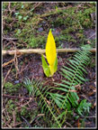 Skunk Cabbage |
 Bare Ground |
 On The Road |
 Coltsfoot |
 Near Summit |
 Mt. Rainier |
 Bikers On East Tiger |
 Low Fog |
 Road Walking |
 Trees Over Quarry |
 Another Big Bridge |
 Mossy Arbor |
 Maintenance Road |
 NW Timber Trail |
 Green Border |
 Very Green |
 Clearcut |
 Many Yellow Violets |
 One Small Violet |
 More Mossy Trees |
 Striped Trees |
 Nice Green Color |
 One More |
 Trillium |
Trips - 2022
Home