01-09-22
Saturday
I did my first hike of the new year. An 8 mile 1200' gain trip on
Cougar Mountain. That was the first day without rain all week. This day
looked to be better. No rain and some afternoon sunshine. The rain
would return on Monday for most of the next week. I made the most of
the weekend. To complicate things, a huge snow storm closed Stevens,
Snoqualmie, Blewett, and White Passes for days. There would be no
skiing and no hiking in the mountains this weekend. I-90 was closed
from North Bend to Ellensburg. All recreating would be on close in
trails. Even the Middle Fork Snoqualmie Road was buried with snow. The
Mt. Si lot was a quagmired of snow. I planned a trip with no views and
bicycles. I would see bikes but hopefully few folks hiking. Grand Ridge
it would be. I had done up to 15 miles on Grand Ridge. There is
shortage of mileage on this very close in trail system. Hikers do not
like to hike bike trails and I find a bit of solitude on this trail. I
knew that would not include a lack of bikes this day. I started early
as bike are fast and they can start later and still get done early. I
arrived at the High Point Trailhead off I-90 at 8:03 am. By 8:08 am I
was on my way. There were a few guys milling around two cars but I
never saw them again.
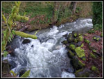
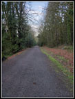
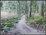
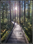
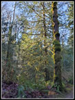
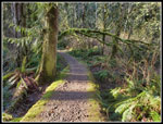
It was right at freezing as I hiked downhill on the old railroad grade. Not a good way to warm up. I had a wind shirt on from the start. Issaquah Creek had lots of water and was making quite a bit of noise. My route would not include any creeks to cross except on bridges. No water problems. No mud problems either. It snowed down here a week earlier and then rained all week washing away the snow. I expected mud. I did not get much. I was glad to leave the grade and start climbing. It finally allowed me to start warming up. Contrary to the forecast the sky was blue. There were no clouds all day long. That had not happened in the Seattle area in a long time. I could feel the 8 miles I hiked the day before but it only slowed me down a little. The nice grade makes this a fast trail to hike. I reached the junction with the trail from the Central Park Trailhead at about 1.6 miles and still had not seen a single person. So far very good.
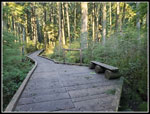
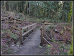
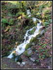
I planned to go all the way to the Michael O. Bridge and maybe up to the road above where the Duthie Hill bike trail system is located. The key would be my right heel. My case of plantar fasciitis is slowly improving but a long trip after 8 miles the day before was asking a lot. If it began to throb, I would turn around early. Unlike the day before on Cougar Mountain I had on low top boots and left the folding saw behind. Two good calls. Very little running water on the trail and no down logs or branches needing to be cut out. The highest point on the trail is only about 1000' and that was below the snow level. I continued on the trail with only photo breaks. Past the paved road to the first Water Tower Loop trail junction at 2.5 miles. I was now starting to see a couple of bikers and a couple runners. The trail descends for half a mile to the next junction with the Water Tower Loop. It drops to cross a small creek on a boardwalk.
The router begins to climb. I was now kicking around taking the way trail over to Mitchell Hill. I had seen the boot path heading off quite a few years ago. A land acquisition added more acreage to the park near Mitchell Hill. Perhaps today would be a chance to check it out. The boot path snows up on my Gaia gps map showing .60 mile sand about 300' of gain to a pave road at the end. If my heel was not doing too bad I decided to give it a go on the way back. I had no trouble finding the start of the route as I passed by. Right about there the trail begins to descend to Canyon Creek and the WTA Bridge. It was now noticeably warmer. I had taken off the wind shirt earlier and now my gloves came off. Soon I even rolled up my wool shirt sleeves thought the poly pro layer sleeves remained down. It had to be approaching 40 degrees. I dropped to the WTA bridge at about 4.25 miles, arriving at 9:45 am. 4.25 miles in 1:37 with a lot of photo stops was not too bad. The heel still felt good. Beyond the bridge I came to the lone erratic rock right alongside the trail. I always take a selfie here. I very seldom take any selfies.
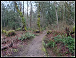
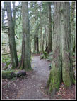
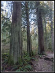
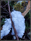
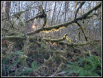
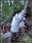
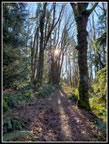
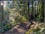
The route continues through a forest of good sized cedar trees. The bikes fly on by. I always slow down to enjoy the big trees. Just before the trail begins to drop down to the Michael O Bridge the temperature took a nosedive. It must have dropped 10 degrees in five minutes. The sleeves rolled down and the gloves went back on. All was not bad as I started to notice some hair ice. This amazing display of bright white hair follicle like stuff is really neat. I only see it a few times each year and this display started slow but kept getting better and better. Some of the patches were really good. I slowed way down and took a lot of photos, hoping some would turn out perfectly focused. Some did. I finally picked up the pace again and arrived at the lowest point, the Michael O Bridge, at 10:24 am. This was just about at the 6 mile mark. I took 2:16 to hike that 6 miles. The bridge itself was coated in ice. It did not look like ice but I had to be careful not to slip and fall. I continued all the way to the far end. I had come this far and decided to climb up to the road above. That added about 170' of gain in .35 miles. I started to see families with a couple groups of 4-6 bikes passing by me. Right near the start of the Grand Ridge Trail.
I popped out at the road and crossed over to the Duthie Hill side. Time for a lunch break. An early lunch but I was hungry after hiking 6.4 miles. I arrived at 10:37 am and headed back at 10:45 am. Down to the bridge then uphill through the hair ice display once again. I stopped for even more hair ice photos. I was glad to top out on the plateau above as the temperature began to quickly rise. From around freezing back up to the low 40s in just minutes. Off went the gloves and up went the sleeves. By the time I reached the WTA Bridge my heel was starting to hurt. I still had 4.25 miles to go. Uphill hurts less and the next section was uphill. At the top of the hill I had one last decision to make. Mitchell Hill or not? What the heck. I started up the boot path. The path was completely covered with big maple leaves. I could seldom see dirt. It was not hard to stay on the path. The 300' happens at the start. It is pretty steep. I was really slowing down here. I had about 17 miles done since yesterday morning.
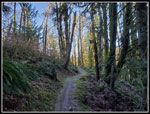
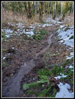
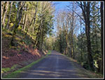
The route did flatten out and I started to see some snow. The trail was also a creek in one spot. I continued on, now with bright sunshine right in my face. I could hardly see anything ahead. I did see one hikers who passed me near the end heading the other way. I ended up popping out of the woods to a paved road. The signs said that continuing onto the road was highly frowned upon. I did not do so. I turned around and headed back. Down the steep path and back to the Grand Ridge Trail. My heel was making itself known. A bit of a limp but not continuous pain. I would get out okay but the last 3.5 miles were not a lot of fun. The crowds had now really shown up. I few hikers and a whole lot of mountain bikers. They do pass by very quickly. I stood off the trail a few dozen dimes as they sped past. I was really glad to get back down tot he railroad grade. Just a last .6 or so miles back to the car. I arrived at 2:05 pm. Just under 6 hours on the trail. I traveled 14 mils with 2200' of elevation gain. Not bad for a trail that never gets above 1300' and 1000' without the Mitchell Hill Trail.
I accomplished all my goals this weekend. I got in my first two hikes of the new year. I traveled 22 miles and gained 3400'. I did not have crazy crowded trails on a weekend when everyone was kept out of the mountains. On the drive home my car registered a temperature of 52 degrees outside. That is the highest temperature I can recall in many weeks. It only lasted one day but it sure was nice. Soon, I can get back to snowshoeing and cross country skiing. This weekend I stayed low and got in a lot of mileage.
Click on thumbnails to get
larger pictures.
Trips - 2022
Home
It was right at freezing as I hiked downhill on the old railroad grade. Not a good way to warm up. I had a wind shirt on from the start. Issaquah Creek had lots of water and was making quite a bit of noise. My route would not include any creeks to cross except on bridges. No water problems. No mud problems either. It snowed down here a week earlier and then rained all week washing away the snow. I expected mud. I did not get much. I was glad to leave the grade and start climbing. It finally allowed me to start warming up. Contrary to the forecast the sky was blue. There were no clouds all day long. That had not happened in the Seattle area in a long time. I could feel the 8 miles I hiked the day before but it only slowed me down a little. The nice grade makes this a fast trail to hike. I reached the junction with the trail from the Central Park Trailhead at about 1.6 miles and still had not seen a single person. So far very good.
I planned to go all the way to the Michael O. Bridge and maybe up to the road above where the Duthie Hill bike trail system is located. The key would be my right heel. My case of plantar fasciitis is slowly improving but a long trip after 8 miles the day before was asking a lot. If it began to throb, I would turn around early. Unlike the day before on Cougar Mountain I had on low top boots and left the folding saw behind. Two good calls. Very little running water on the trail and no down logs or branches needing to be cut out. The highest point on the trail is only about 1000' and that was below the snow level. I continued on the trail with only photo breaks. Past the paved road to the first Water Tower Loop trail junction at 2.5 miles. I was now starting to see a couple of bikers and a couple runners. The trail descends for half a mile to the next junction with the Water Tower Loop. It drops to cross a small creek on a boardwalk.
The router begins to climb. I was now kicking around taking the way trail over to Mitchell Hill. I had seen the boot path heading off quite a few years ago. A land acquisition added more acreage to the park near Mitchell Hill. Perhaps today would be a chance to check it out. The boot path snows up on my Gaia gps map showing .60 mile sand about 300' of gain to a pave road at the end. If my heel was not doing too bad I decided to give it a go on the way back. I had no trouble finding the start of the route as I passed by. Right about there the trail begins to descend to Canyon Creek and the WTA Bridge. It was now noticeably warmer. I had taken off the wind shirt earlier and now my gloves came off. Soon I even rolled up my wool shirt sleeves thought the poly pro layer sleeves remained down. It had to be approaching 40 degrees. I dropped to the WTA bridge at about 4.25 miles, arriving at 9:45 am. 4.25 miles in 1:37 with a lot of photo stops was not too bad. The heel still felt good. Beyond the bridge I came to the lone erratic rock right alongside the trail. I always take a selfie here. I very seldom take any selfies.
The route continues through a forest of good sized cedar trees. The bikes fly on by. I always slow down to enjoy the big trees. Just before the trail begins to drop down to the Michael O Bridge the temperature took a nosedive. It must have dropped 10 degrees in five minutes. The sleeves rolled down and the gloves went back on. All was not bad as I started to notice some hair ice. This amazing display of bright white hair follicle like stuff is really neat. I only see it a few times each year and this display started slow but kept getting better and better. Some of the patches were really good. I slowed way down and took a lot of photos, hoping some would turn out perfectly focused. Some did. I finally picked up the pace again and arrived at the lowest point, the Michael O Bridge, at 10:24 am. This was just about at the 6 mile mark. I took 2:16 to hike that 6 miles. The bridge itself was coated in ice. It did not look like ice but I had to be careful not to slip and fall. I continued all the way to the far end. I had come this far and decided to climb up to the road above. That added about 170' of gain in .35 miles. I started to see families with a couple groups of 4-6 bikes passing by me. Right near the start of the Grand Ridge Trail.
I popped out at the road and crossed over to the Duthie Hill side. Time for a lunch break. An early lunch but I was hungry after hiking 6.4 miles. I arrived at 10:37 am and headed back at 10:45 am. Down to the bridge then uphill through the hair ice display once again. I stopped for even more hair ice photos. I was glad to top out on the plateau above as the temperature began to quickly rise. From around freezing back up to the low 40s in just minutes. Off went the gloves and up went the sleeves. By the time I reached the WTA Bridge my heel was starting to hurt. I still had 4.25 miles to go. Uphill hurts less and the next section was uphill. At the top of the hill I had one last decision to make. Mitchell Hill or not? What the heck. I started up the boot path. The path was completely covered with big maple leaves. I could seldom see dirt. It was not hard to stay on the path. The 300' happens at the start. It is pretty steep. I was really slowing down here. I had about 17 miles done since yesterday morning.
The route did flatten out and I started to see some snow. The trail was also a creek in one spot. I continued on, now with bright sunshine right in my face. I could hardly see anything ahead. I did see one hikers who passed me near the end heading the other way. I ended up popping out of the woods to a paved road. The signs said that continuing onto the road was highly frowned upon. I did not do so. I turned around and headed back. Down the steep path and back to the Grand Ridge Trail. My heel was making itself known. A bit of a limp but not continuous pain. I would get out okay but the last 3.5 miles were not a lot of fun. The crowds had now really shown up. I few hikers and a whole lot of mountain bikers. They do pass by very quickly. I stood off the trail a few dozen dimes as they sped past. I was really glad to get back down tot he railroad grade. Just a last .6 or so miles back to the car. I arrived at 2:05 pm. Just under 6 hours on the trail. I traveled 14 mils with 2200' of elevation gain. Not bad for a trail that never gets above 1300' and 1000' without the Mitchell Hill Trail.
I accomplished all my goals this weekend. I got in my first two hikes of the new year. I traveled 22 miles and gained 3400'. I did not have crazy crowded trails on a weekend when everyone was kept out of the mountains. On the drive home my car registered a temperature of 52 degrees outside. That is the highest temperature I can recall in many weeks. It only lasted one day but it sure was nice. Soon, I can get back to snowshoeing and cross country skiing. This weekend I stayed low and got in a lot of mileage.
 Issaquah Creek |
 Railroad Grade |
 Uphill Time |
 Small Cedar Trees |
 WTA Bridge |
 Run! |
 Big Cedar Trees |
 Hair Ice |
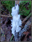 Another Hair Ice |
 Michael O. Bridge |
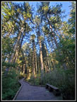 Tall Trees |
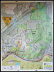 Map |
 Sunshne |
 Lit Up Moss |
 One More Hair Ice |
 Up To The Plateau |
 Moss & Sunshine |
 Second Bridge |
 Nice Sunshine |
 Creek/Trail & Snow |
 Low Spot |
 Biker |
 Back On Grade |
 Waterfall |
Trips - 2022
Home