04-13-24
The
weekend was looking to be sunny
and warm. I hoped to head east of the crest for spring wildflowers but
they seem to still be several weeks short of prime. I kicked around
some other ideas and decided on a long local hike. It has lots of
miles, great views, and few people. The downside is that it is a road
walk. Solitude and views make up for the road. I last did this
trip in
late December when the upper mountain had fresh overnight snowfall. The
trees were heavily flocked and there were no tracks in the snow.
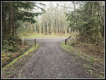
Without snow this is an easier trip. I was on the road at 7:50 am
heading east. The start is off of I-90 and onto southbound Highway 18.
The turn comes up quickly and the turn lane is gone during
construction. I was parked at 7:32 am. There were two cars already
there. I did not see the owners all day. I was on my way at 7:37 am. It
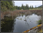
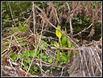
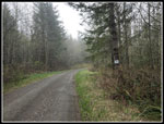
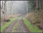
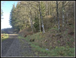
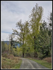
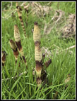
was only 42 degrees. I went around the gate and headed across the marsh
on the paved road. I noticed some blooming skunk cabbage. The road
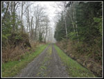
turns right and climbs a bit and then it is flat for more than 1.5
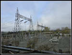
miles. Pavement ends in less than half a mile. At one mile I passed the
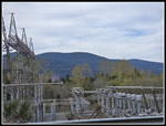
big power sub-station. The clouds were
so low I could not see any of Tiger Mountain across the valley. The
forecast 40% overcast was more like 100%.
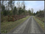
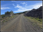
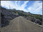
I made good time on the flats as the half mile markers zoomed by. After mile 2 the road turns left and starts to climb. It parallels Canyon Creek which can be heard. The road makes a 180 degree turn as it crosses the creek. There are bike trails before and after the bridge. They are downhill bike only trails. I did hike the second one before it opened. It is steep and narrow and hikers should avoid it. The road makes another 180 degree switchback and heads up the steep road. Along here I was passed by 8 cars. I think they were likely volunteer mountain bike trail workers. Later in the day I found a pile of tools but did not see the cars again. I have occasionally seen a truck go by heading to the towers but never a convoy on this gated road.
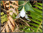
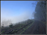
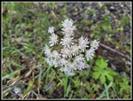
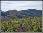
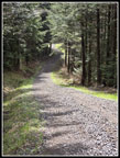
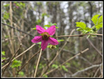
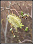
I passed the 3 mile marker on the hill. At the top the road turns right and the grade eases. I quickly passed the road I would take on a detour coming down. The detour brings the mileage of this trip up to 17. I saw a few salmonberry flowers and then more and more coltsfoot flowers. I saw a lot of the latter much of the way. Down low, I saw a lot of bleeding heart plants. Only one had a couple flowers just beginning to appear. In a few weeks there will be a lot of color. I passed the 4 mile sign and at the 4.5 mile sign I reached my junction. The correct route is a left turn on a steeply ascending road. I took a short food and water break at the junction. I took 1:19 to hike the 4.5 miles and gain 1000'. 3.5 mph is a very good speed for me. It would slow down as I gained 1500' in the next 3.6 miles. That is still not very steep but has some steep sections. Most of the way up to here is in forest. Now I would go from forest to clearcuts and back. As I ascended the overcast was thinning but I was still in the clouds.
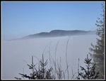
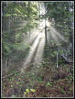
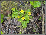
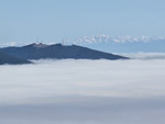
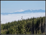
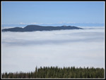
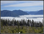
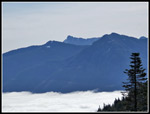
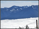
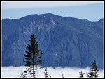
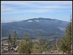
By the 5.5 mile marker the clearcuts were the norm. It was still too cloudy to see Tiger Mountain. At about 6 miles I rose out of the clouds. I could now see the tops Tiger Mountain but nothing below me. Alongside the road I saw a few blooming trillium in the forest sections. I also began to see patches of blooming yellow violets. I saw more wildflowers than expected. Just beyond 6.5 miles (no sign) I reached the road that comes up from Snoqualmie Point. This road seems to be more used to reach the towers. The mile markers now are for that road. I reached the first bike crossing and a biker zoomed across right in front of me. He was the first person I had seen. If I was a minute earlier or later I would not have seen him. The tower was now seen above as the recent clearcut goes all the way down from the summit to here. The bike trail is all in the clearcut heading up. The road soon goes back into forest. Where it switches back, the Rattlesnake Mountain Trail comes within less than 100' of the road. Hikers on the trail do not realize this. I have heard hikers talking on the trail. Not his day. I was soon back out in the open and now I was high enough above the clouds to have some great views.
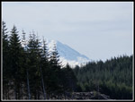
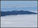
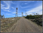
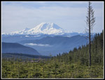
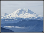
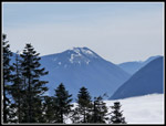
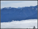
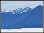
East Tiger and West Tiger 1 appeared to be islands in the sea of clouds. Behind them were the Olympic Mountains. Below was the top of the cloud layer. It was lit up by the sunshine. There were still some clouds above but there was also a lot of sunshine. It felt much warmer now. Two bikers passed by heading up the road. They stopped for a break and to take some photos. I passed them. I could now see Mt. Baker and Three Fingers to the north. As the road neared the last switchback before the summit, I could see about half of Mt. Rainier. It was clearer than I was expecting. I rounded the final switchback and the towers were now right in front of me. It just took a few minutes to reach the top. There was a light breeze but it was warm enough in the sunshine. I did put on a windshirt here. I left the road and took a short walk to a point where I had a clear view of Mt. Rainier. While it was not seen against a blue sky, it was still pretty clear. I was impressed with the photos. At home I checked and the top of Mt. Rainier is 58 miles form downtown Seattle and only 42 miles from West Rattlesnake Mountain. It looks pretty big.
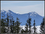
I walked around the summit area to get the best views. I could see north to Baker and Three Fingers. West to Tiger Mountain and the Olympic Mountains. East to Mt Si, Teneriffe, and peaks up the MF Snoqualmie and SF Snoqualmie Rivers. I used software to distinguish the peaks and was surprised to be able to identify, Kyes, Index, Persis, Hinman, Daniel, Chimney Rock, Kaleetan, Big Snow, and more. Granite Mountain is still very white with snow. I saw many more peaks than I previously knew to be visible from there. I had lunch and debated when to head down. I still had more than 8.5 miles to go. On the other hand, I had great views and sunshine on the summit. Below in most directions it was still low clouds/fog. It was much darker in North Bend than on the summit. I was close to leaving when two mountain bikers arrived. We ended up having a long hiking/climbing discussion. I reached the summit at 10:27 am. I hiked 8.1 miles in 2:50 including breaks and photo stops. That is 2.9 mph. That is very good for me. I headed down at 11:38 am. I spent over one hour on top.
Going down was easier. I also had great view up high and took a lot more photo stops. I also was not thrilled with dropping back into the clouds. My pace was less than it could have been. I saw a few more bikers at the junctions where the trails cross the road. After that it was almost total solitude going down. On my detour I did see two more bikers. The descent was pretty easy but the total miles began to be felt. I average about 9.5 miles per day and this would be nearly double that. I reached the 4.5 mile junction at 1:00 pm. The grade became much gentler. I took the detour over to Canyon Creek and added .67 miles. That brought my route up to 17 miles. I ran into the two bikers mentioned earlier. The last people I saw this day. I stopped at the bridge and took a few macro photos of very small flowers. I still do not have a consistent way to get them in focus. I need more practice with the new camera. I headed back to the main road and then down the steep grade to the lower Canyon Creek Bridge. I saw two cars parked just below the bridge. The owners were likely working on one of the two bike trails that end near the bridge. The last 2.5 miles were a grunt.
In previous years I have had a touch of plantar fasciitis and the last few miles were very painful. The hike last December and this one were done with no plantar pain. It really made a big difference. My feet were tired at the one mile marker but I was not in pain. The last straightaway across the marsh seemed to drag on but I did see more skunk cabbage and new leaves to photograph. I made it back to my car at 2:53 pm. My trip down was 8.8 miles in 3:15. With the detour, it was a little longer than the hike up and took 25 minutes longer. I was moving pretty slow above the cloud level.
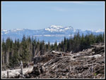
This turned out to be a good choice for the day. It was not as clear as expected but I had great views of peaks and the top of the cloud layer from up high. As expected, I saw almost nobody until I passed the bike trails near the summit. In over an hour on top I saw just the two bikers I spoke with. It was even quieter than usual. The December trip had total solitude due to a winter day with fresh snow on everything up high. That was a fluke. The snow on peaks made for great scenery. The "Tiger Islands" with most of the mountains under the clouds and just the tops sticking out was a nice surprise. Mt. Rainier was very impressive. The mountain has been clearcut and that is unfortunate but it now provides great views in nearly every direction. From 15 to 17 miles in one day is usually the longest mileage I get in during a year. I now already have the upper end of that range done in just the fourth month of the year. This is a challenging day as I grow older and it's nice to be able to still do it at a good pace. I had a great day in the close in mountains.
Click on thumbnails to get
larger pictures.
Trips - 2024
Home
I made good time on the flats as the half mile markers zoomed by. After mile 2 the road turns left and starts to climb. It parallels Canyon Creek which can be heard. The road makes a 180 degree turn as it crosses the creek. There are bike trails before and after the bridge. They are downhill bike only trails. I did hike the second one before it opened. It is steep and narrow and hikers should avoid it. The road makes another 180 degree switchback and heads up the steep road. Along here I was passed by 8 cars. I think they were likely volunteer mountain bike trail workers. Later in the day I found a pile of tools but did not see the cars again. I have occasionally seen a truck go by heading to the towers but never a convoy on this gated road.
I passed the 3 mile marker on the hill. At the top the road turns right and the grade eases. I quickly passed the road I would take on a detour coming down. The detour brings the mileage of this trip up to 17. I saw a few salmonberry flowers and then more and more coltsfoot flowers. I saw a lot of the latter much of the way. Down low, I saw a lot of bleeding heart plants. Only one had a couple flowers just beginning to appear. In a few weeks there will be a lot of color. I passed the 4 mile sign and at the 4.5 mile sign I reached my junction. The correct route is a left turn on a steeply ascending road. I took a short food and water break at the junction. I took 1:19 to hike the 4.5 miles and gain 1000'. 3.5 mph is a very good speed for me. It would slow down as I gained 1500' in the next 3.6 miles. That is still not very steep but has some steep sections. Most of the way up to here is in forest. Now I would go from forest to clearcuts and back. As I ascended the overcast was thinning but I was still in the clouds.
By the 5.5 mile marker the clearcuts were the norm. It was still too cloudy to see Tiger Mountain. At about 6 miles I rose out of the clouds. I could now see the tops Tiger Mountain but nothing below me. Alongside the road I saw a few blooming trillium in the forest sections. I also began to see patches of blooming yellow violets. I saw more wildflowers than expected. Just beyond 6.5 miles (no sign) I reached the road that comes up from Snoqualmie Point. This road seems to be more used to reach the towers. The mile markers now are for that road. I reached the first bike crossing and a biker zoomed across right in front of me. He was the first person I had seen. If I was a minute earlier or later I would not have seen him. The tower was now seen above as the recent clearcut goes all the way down from the summit to here. The bike trail is all in the clearcut heading up. The road soon goes back into forest. Where it switches back, the Rattlesnake Mountain Trail comes within less than 100' of the road. Hikers on the trail do not realize this. I have heard hikers talking on the trail. Not his day. I was soon back out in the open and now I was high enough above the clouds to have some great views.
East Tiger and West Tiger 1 appeared to be islands in the sea of clouds. Behind them were the Olympic Mountains. Below was the top of the cloud layer. It was lit up by the sunshine. There were still some clouds above but there was also a lot of sunshine. It felt much warmer now. Two bikers passed by heading up the road. They stopped for a break and to take some photos. I passed them. I could now see Mt. Baker and Three Fingers to the north. As the road neared the last switchback before the summit, I could see about half of Mt. Rainier. It was clearer than I was expecting. I rounded the final switchback and the towers were now right in front of me. It just took a few minutes to reach the top. There was a light breeze but it was warm enough in the sunshine. I did put on a windshirt here. I left the road and took a short walk to a point where I had a clear view of Mt. Rainier. While it was not seen against a blue sky, it was still pretty clear. I was impressed with the photos. At home I checked and the top of Mt. Rainier is 58 miles form downtown Seattle and only 42 miles from West Rattlesnake Mountain. It looks pretty big.
I walked around the summit area to get the best views. I could see north to Baker and Three Fingers. West to Tiger Mountain and the Olympic Mountains. East to Mt Si, Teneriffe, and peaks up the MF Snoqualmie and SF Snoqualmie Rivers. I used software to distinguish the peaks and was surprised to be able to identify, Kyes, Index, Persis, Hinman, Daniel, Chimney Rock, Kaleetan, Big Snow, and more. Granite Mountain is still very white with snow. I saw many more peaks than I previously knew to be visible from there. I had lunch and debated when to head down. I still had more than 8.5 miles to go. On the other hand, I had great views and sunshine on the summit. Below in most directions it was still low clouds/fog. It was much darker in North Bend than on the summit. I was close to leaving when two mountain bikers arrived. We ended up having a long hiking/climbing discussion. I reached the summit at 10:27 am. I hiked 8.1 miles in 2:50 including breaks and photo stops. That is 2.9 mph. That is very good for me. I headed down at 11:38 am. I spent over one hour on top.
Going down was easier. I also had great view up high and took a lot more photo stops. I also was not thrilled with dropping back into the clouds. My pace was less than it could have been. I saw a few more bikers at the junctions where the trails cross the road. After that it was almost total solitude going down. On my detour I did see two more bikers. The descent was pretty easy but the total miles began to be felt. I average about 9.5 miles per day and this would be nearly double that. I reached the 4.5 mile junction at 1:00 pm. The grade became much gentler. I took the detour over to Canyon Creek and added .67 miles. That brought my route up to 17 miles. I ran into the two bikers mentioned earlier. The last people I saw this day. I stopped at the bridge and took a few macro photos of very small flowers. I still do not have a consistent way to get them in focus. I need more practice with the new camera. I headed back to the main road and then down the steep grade to the lower Canyon Creek Bridge. I saw two cars parked just below the bridge. The owners were likely working on one of the two bike trails that end near the bridge. The last 2.5 miles were a grunt.
In previous years I have had a touch of plantar fasciitis and the last few miles were very painful. The hike last December and this one were done with no plantar pain. It really made a big difference. My feet were tired at the one mile marker but I was not in pain. The last straightaway across the marsh seemed to drag on but I did see more skunk cabbage and new leaves to photograph. I made it back to my car at 2:53 pm. My trip down was 8.8 miles in 3:15. With the detour, it was a little longer than the hike up and took 25 minutes longer. I was moving pretty slow above the cloud level.
This turned out to be a good choice for the day. It was not as clear as expected but I had great views of peaks and the top of the cloud layer from up high. As expected, I saw almost nobody until I passed the bike trails near the summit. In over an hour on top I saw just the two bikers I spoke with. It was even quieter than usual. The December trip had total solitude due to a winter day with fresh snow on everything up high. That was a fluke. The snow on peaks made for great scenery. The "Tiger Islands" with most of the mountains under the clouds and just the tops sticking out was a nice surprise. Mt. Rainier was very impressive. The mountain has been clearcut and that is unfortunate but it now provides great views in nearly every direction. From 15 to 17 miles in one day is usually the longest mileage I get in during a year. I now already have the upper end of that range done in just the fourth month of the year. This is a challenging day as I grow older and it's nice to be able to still do it at a good pace. I had a great day in the close in mountains.
 Reflection |
 Skunk Cabbage |
 Passing Power Station |
 New Trail Bridges |
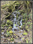 Cascading Creek |
 Blooming Coltsfoot |
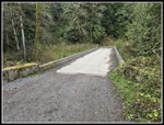 Canyon Creek Bridge |
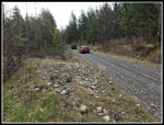 Car Caravan |
 Misty At 3.5 Miles |
 Junction At 4.5 Miles |
 Grassy Road |
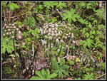
 Trillium |
 Getting More Misty |
 Dark With Blue Above |
 Tiger Mt. Appears |
 Sun Rays |
 6 Miles Done |
 More Coltsfoot |
 Yellow Violets |
 Sunshine! |
 Tiger Island & Olympics |
 Towers In Sight |
 Mt. Baker |
 Mt. Rainier In Sight |
 A Sea Of Clouds |
 Tiger 1 & Mt. Constance |
 Almost On Summit |
 Beautiful Mt. Rainier |
 Mt. Rainier Close Up |
 East Rattlesnake Mt. |
 Looking East |
 Bandera Mountain |
 McClellan Butte |
 More East Views |
 Revolution & Mailbox Pks |
 Opening Coltsfoot |
 Mt. Si |
 Hinman & Big Snow |
 Granite Mountain |
 Mt. Index |
 Descending |
 Tiger Is Clear Now |
 Mossy Rock |
 Leafy Trees |
 One Mile To Go |
 Salmonberry Flower |
 Reeds |
 Spring Has Sprung |
Trips - 2024
Home