08-30-25
Gary
is headed off for a three week vacation and wanted to get in a last
strenuous hike. He had a couple suggestions and I liked West Cady Ridge
possibly all the way to Benchmark Mountain. I had backpacked to
Benchmark twice. I had not done it as a day hike. At about 14 miles
with around 4000' of gain it is a long day hike. One can turn around at
any point happy with a good hike. It was the Saturday of Labor Day
Weekend so we planned an early start. We met in Bothell at 6:15 am and
Gary drove east. The Index-Galena road washed out in 2006 and was not
reopened until the end of 2023. I had not been on it since one year
before the washout. Previous visits to West Cady Ridge were via the
dirt road over Jack Pass. This would make the drive much easier. We
arrived at the trailhead at about 7:35 am. There were about nine or ten
cars in the lot. The lot is for West Cady Ridge, Quartz Creek, and the
North Fork Skykomish Trails. There were more cars than I expected, even
on a holiday weekend. We packed up and were on the trail at 7:45 am.
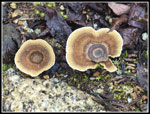
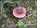
Immediately we saw some mushrooms and lots of bright orange
bunchberries. The bridge over the NF Skykomish came up fast. The Wild
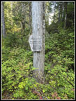
Sky Wilderness begins across the bridge.
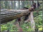
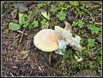
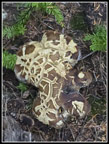
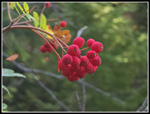
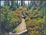
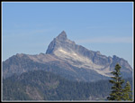
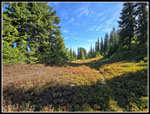
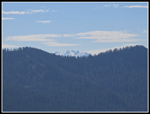
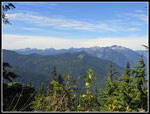
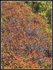
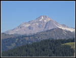
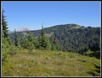
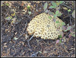
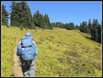
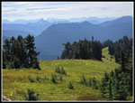
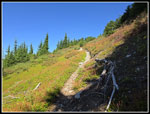
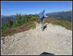
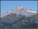
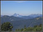
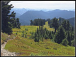
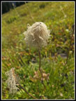
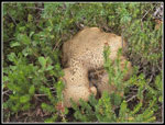
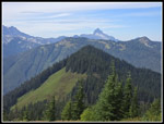
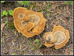
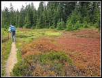
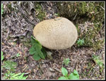
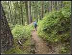
The trail is well graded as it climbs up West Cady Ridge. There was one tree busted into parts and a big tree about six feet above the trail. I saw one old coralroot but no other saprophytes. Wildflowers are just about finished. Fresh mushrooms showed up all along our route. Since recent rains they have been appearing. The trail reached the nose of the ridge and began steeper switchbacks up the slope. In the forest below we saw some blueberries but they were tart. Now, as we moved into some more open areas the berries became riper. Bright orange serviceberries also appeared. We kept heading higher until reaching about 4700' at about 3 miles. We started getting views out to Kyes Peak. We took a couple short side trail to the right and the left. Sloan Peak was next in view then Glacier Peak. We saw these peaks a week earlier from the other side at Meadow Mountain. Like Meadow Mountain, we were seeing a whole lot of ripe blueberries and huckleberries. In a weeks time we had two of the best berry hikes in years. Progress was steady with a lot of short berry stops.
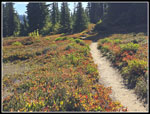
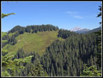
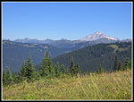
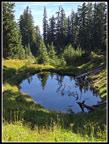
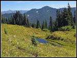
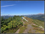
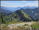
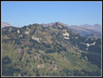
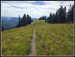
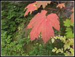
We caught up with three guys out bear hunting. Over the course of the day we passed or were passed by them six times. Leap frog on the trail. The berry bushes began to have very red leaves. Low morning light lit them up. It looked more like late September color than late August. The trail has several drops of 200'+ that are fun climbs on the way back. As we continued up the ridge views continued at times. We saw Mt. Stuart, Daniel, Hinman, Overcoat, and many Wild Sky peaks to the south. To the north it was Kyes, the Monte Cristo Peaks, Sloan, White Chuck, Baker, and Glacier Peak. The trail reaches the Henry M Jackson Wilderness at the top of a high point and drops to two ponds. One was very murky and one clearer. Now we had a lot of grassy meadows as the trail began to climb the ridge towards Benchmark. By the time we reached the wilderness boundary we had decided to go for Benchmark. We took a break in the shade as the sunshine was getting warmer. We were soon back on our way.
A group of young hikers caught up with us and zoomed by. They accounted for five of the eight people we saw on the way up. We saw the trail heading left a short way into trees where we camped in 2021. The trail began to flatten out. In a few minutes we realized we had likely made a mistake. The GPS confirmed it. We angled up and found the summit trail quickly. The trail jogged left to almost the campsites then headed up to the summit. It was clear on the way down. The last 300' in .30 miles went pretty quickly we reached the ridge top near the old lookout site expecting to see the five hikers. We did see them but several hundred feet below us. A trail drops steeply down and continues to the Pacific Crest Trail. The five hikers were near where the straight down trail meets the trail we accidentally hiked earlier. We don't know if they took the lower trail or went to the summit and immediately dropped down. Either way, we had the summit to ourselves. We went to the lookout site and continued to the other end of the summit ridge.
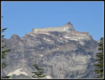
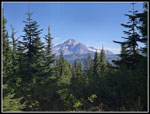
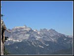
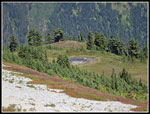
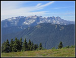
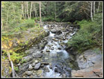
The views are good on the way up. They are a lot better on the summit. Now we had nearly 360 degree views. Glacier Peak dominated to the north. With a peakfinder app we were able to locate Mt. David, Indian Head Peak, and others. Without it we found Johnson Mountain with Bald Eagle Ridge and Pilot Ridge leading towards it. To the left of Glacier we saw Black, Magenta, Painted, and Portal peaks. We arrived at 12:50 pm and stayed on the top until 1:52 pm. There were three tarns below the east side of the summit that had plenty of water in late September 2021. They have much less water now. This has been a dry summer and it shows. Other than a few small creeks near the start there was no other water on this route. After an hour on top we wandered back to where we reached the summit. We descended a short way and stopped for more berries. Gary filled a small water bottle while I just ate berries. It was 2:10 pm when we actually began our descent.
We saw only those two groups on our way up. On the way down we saw quite a few more. It was bear hunting weekend as we saw two more groups of young camouflaged men with rifles. We asked each if they were hunting bear and they were. We are used to seeing deer hunters in October wearing bright orange. All three groups this day wore camouflage. We saw another four or so groups heading up to camp. Two runners with a dog passed us by heading up. All totaled, we saw 22 people. 14 were seen while we were descending and they were heading up. Other than the two runners and two day hikers, the other 18 were camping on Benchmark. I wonder if they all found a spot for tents and water? As mentioned earlier, the trail is moderately graded which helps us older hikers on the descent. The main cause of our slow downs was more berry stops. We stuck to the trail coming down. We felt good at 10 and 11 miles but the last few miles were a bit tougher. It is about 3600' net from trailhead to summit but with those ups and downs we logged 4400' of gain. I made good uss of my chrome dome umbrella on the last part up, on the summit, and for part of the descent. The sunshine of the morning gave way to cloud cover part way down. That made it much more humid.
I was glad when we dropped off the ridge and went back into forest. The last few miles were not hared but the distance and elevation gain made it tougher. I was glad to see the bridge and we reached the parking lot at 5:49 pm. The lot was now about full though another group left just ahead of us creating several open spots. The drive home was easy. The middle day of a three day weekend usually has light traffic, even on Highway 2. I arrived home right about at dark.
This was a very successful day hike. We covered a lot of mile and elevation gain five days after a three day backpacking trip. The berries were really thick and ripe. We saw fields of them and only ate a small amount right next to the trail. The bears will eat well this year. We had good views at Meadow Mountain but they were a bit hazy. This day was much clearer. Other than Glacier Peak there are no much higher close by peaks leaving us with long views out to far away peaks. We had nearly total solitude going up except for the three hunters and the big group that zoomed by and was far ahead in no time. We had an hour on the summit with total solitude. The big group was seen below and a few minutes later they were gone. The drive is much easier now that the paved Index-Galena Road is open. There is no need to drive the dusty steep road over Jack Pass. I was surprised that the distance from Bothell to the trailhead was less than 54 miles. And don't forget the crazy bright red fall colors in August. All in all, it was a great day in the mountains.
Click on thumbnails to get
larger pictures.
Trips - 2025
Home
The trail is well graded as it climbs up West Cady Ridge. There was one tree busted into parts and a big tree about six feet above the trail. I saw one old coralroot but no other saprophytes. Wildflowers are just about finished. Fresh mushrooms showed up all along our route. Since recent rains they have been appearing. The trail reached the nose of the ridge and began steeper switchbacks up the slope. In the forest below we saw some blueberries but they were tart. Now, as we moved into some more open areas the berries became riper. Bright orange serviceberries also appeared. We kept heading higher until reaching about 4700' at about 3 miles. We started getting views out to Kyes Peak. We took a couple short side trail to the right and the left. Sloan Peak was next in view then Glacier Peak. We saw these peaks a week earlier from the other side at Meadow Mountain. Like Meadow Mountain, we were seeing a whole lot of ripe blueberries and huckleberries. In a weeks time we had two of the best berry hikes in years. Progress was steady with a lot of short berry stops.
We caught up with three guys out bear hunting. Over the course of the day we passed or were passed by them six times. Leap frog on the trail. The berry bushes began to have very red leaves. Low morning light lit them up. It looked more like late September color than late August. The trail has several drops of 200'+ that are fun climbs on the way back. As we continued up the ridge views continued at times. We saw Mt. Stuart, Daniel, Hinman, Overcoat, and many Wild Sky peaks to the south. To the north it was Kyes, the Monte Cristo Peaks, Sloan, White Chuck, Baker, and Glacier Peak. The trail reaches the Henry M Jackson Wilderness at the top of a high point and drops to two ponds. One was very murky and one clearer. Now we had a lot of grassy meadows as the trail began to climb the ridge towards Benchmark. By the time we reached the wilderness boundary we had decided to go for Benchmark. We took a break in the shade as the sunshine was getting warmer. We were soon back on our way.
A group of young hikers caught up with us and zoomed by. They accounted for five of the eight people we saw on the way up. We saw the trail heading left a short way into trees where we camped in 2021. The trail began to flatten out. In a few minutes we realized we had likely made a mistake. The GPS confirmed it. We angled up and found the summit trail quickly. The trail jogged left to almost the campsites then headed up to the summit. It was clear on the way down. The last 300' in .30 miles went pretty quickly we reached the ridge top near the old lookout site expecting to see the five hikers. We did see them but several hundred feet below us. A trail drops steeply down and continues to the Pacific Crest Trail. The five hikers were near where the straight down trail meets the trail we accidentally hiked earlier. We don't know if they took the lower trail or went to the summit and immediately dropped down. Either way, we had the summit to ourselves. We went to the lookout site and continued to the other end of the summit ridge.
The views are good on the way up. They are a lot better on the summit. Now we had nearly 360 degree views. Glacier Peak dominated to the north. With a peakfinder app we were able to locate Mt. David, Indian Head Peak, and others. Without it we found Johnson Mountain with Bald Eagle Ridge and Pilot Ridge leading towards it. To the left of Glacier we saw Black, Magenta, Painted, and Portal peaks. We arrived at 12:50 pm and stayed on the top until 1:52 pm. There were three tarns below the east side of the summit that had plenty of water in late September 2021. They have much less water now. This has been a dry summer and it shows. Other than a few small creeks near the start there was no other water on this route. After an hour on top we wandered back to where we reached the summit. We descended a short way and stopped for more berries. Gary filled a small water bottle while I just ate berries. It was 2:10 pm when we actually began our descent.
We saw only those two groups on our way up. On the way down we saw quite a few more. It was bear hunting weekend as we saw two more groups of young camouflaged men with rifles. We asked each if they were hunting bear and they were. We are used to seeing deer hunters in October wearing bright orange. All three groups this day wore camouflage. We saw another four or so groups heading up to camp. Two runners with a dog passed us by heading up. All totaled, we saw 22 people. 14 were seen while we were descending and they were heading up. Other than the two runners and two day hikers, the other 18 were camping on Benchmark. I wonder if they all found a spot for tents and water? As mentioned earlier, the trail is moderately graded which helps us older hikers on the descent. The main cause of our slow downs was more berry stops. We stuck to the trail coming down. We felt good at 10 and 11 miles but the last few miles were a bit tougher. It is about 3600' net from trailhead to summit but with those ups and downs we logged 4400' of gain. I made good uss of my chrome dome umbrella on the last part up, on the summit, and for part of the descent. The sunshine of the morning gave way to cloud cover part way down. That made it much more humid.
I was glad when we dropped off the ridge and went back into forest. The last few miles were not hared but the distance and elevation gain made it tougher. I was glad to see the bridge and we reached the parking lot at 5:49 pm. The lot was now about full though another group left just ahead of us creating several open spots. The drive home was easy. The middle day of a three day weekend usually has light traffic, even on Highway 2. I arrived home right about at dark.
This was a very successful day hike. We covered a lot of mile and elevation gain five days after a three day backpacking trip. The berries were really thick and ripe. We saw fields of them and only ate a small amount right next to the trail. The bears will eat well this year. We had good views at Meadow Mountain but they were a bit hazy. This day was much clearer. Other than Glacier Peak there are no much higher close by peaks leaving us with long views out to far away peaks. We had nearly total solitude going up except for the three hunters and the big group that zoomed by and was far ahead in no time. We had an hour on the summit with total solitude. The big group was seen below and a few minutes later they were gone. The drive is much easier now that the paved Index-Galena Road is open. There is no need to drive the dusty steep road over Jack Pass. I was surprised that the distance from Bothell to the trailhead was less than 54 miles. And don't forget the crazy bright red fall colors in August. All in all, it was a great day in the mountains.
 Low Clearance |
 First Mushrooms |
 Gorge In River |
 Wilderness Sign |
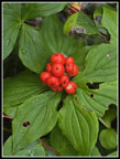 Bunchberries |
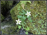 Fringed Grass Of Parnassus |
 Interesting Mushroom |
 Serviceberries |
 Out Of The Forest |
 More Fungus |
 Fall Color Begins |
 Kyes Peak Appears |
 Sloan Peak |
 Meadows & Berries |
 First Glacier Peak View |
 Blue Sky & Fall Colors |
 Improving Colors |
 Great Backlighting |
 Close Up Color |
 Summit Chief Overcoat |
 Mt. Daniel |
 Monte Cristo Peaks |
 Meadowed Slopes |
 Frog Mt & Peaks South |
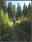
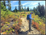 Gary On Trail |
 Tons Of Berries |
 View West |
 Ridges & Glacier Peak |
 Glacier & Johnson Pks |
 First Pond |
 Summit In Sight |
 Another Mushroom |
 Second Pond |
 Big Meadow To Top |
 Looking Back |
 Summit Just Ahead |
 Summit Lookout Site |
 Glacier Peak Close Up |
 Summit Ridge |
 View East |
 Pugh, White Chuck, Baker |
 Skykomish Peak |
 Pond Was Little Water |
 Monte Cristo Peaks |
 Heading Down |
 Almost Endless Meadow |
 Western Anemone |
 Big Mushroom |
 Sloan Over Meadow |
 More Of These |
 Some Color |
 One More Mushroom |
 Last Mushroom |
 Back In Forest |
 Devil's Club Leaves |
 NF Skykomish River |
Trips - 2025
Home