02-26-25
For
the first 60F day of the year, I decided to take half a day off and go
hiking. Gary and John were free too. We met at the Sunset Trailhead at
11:05 am. I drove us down to the Chirico Trailhead. This would be a one
way hike. The lot was more than half full but with plenty of spots
left. We were on our way at 11:19 am. We had not been on this trail for
over five years. One reason is that it is a very crowded trail,
especially on weekends. Another is the hundreds of rocks that now line
the lower trail. They are no fun for our knees with all the rock steps.
It is a good trail for one way trips. We made very good time on the
first part. Too good is seems. After two weekend hikes all the steps
wore me out. I slowed down and let the guys go ahead. Part way up they
stopped and I caught up. There was a school bus in the lot and we
passed a group the must have been more than twenty hikers. There were
other small groups heading up and down. It was cold down low but became
quite warm as we ascended. I was wishing I had a short sleeve shirt to
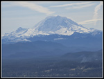
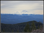
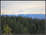
put on. We took a short stop at the lower point. Mt. Rainier was in the
clear and the lighting was very good. We saw Rainier from the summits
later but clouds filled the sky by that point. The best lighting was at
the lower point.
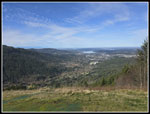
We quickly headed up to the higher point. I expected to see parasailors as we actually had some warmer air thermals. We did not see any at all. We had a longer break at the picnic table at the highest point. The sunshine felt really good. We arrived at 12:25 pm and stayed until 12:42 pm. We could have stayed much longer but we still had a long way to go. Once out of the sun it was much cooler though not cold. We headed over to what is now the bottom of the One View Trail. The trail over is only a few years old. A short climb brought us to the railroad grade intersection. The old trail to Poo Poo Point went off to the right here. It has been obliterated. We went straight ahead and uphill on the One View Trail. There are some ups and downs as the trial climbs the spine of the ridge. We passed Fifteen Mile Gap and then climbed to meet the Tiger Mountain Trail (TMT). We went right on the TMT to the Hidden Forest Trail. Now came one of the steepest sections of the day. It is steep but not very long. A big tree fell here and we had to pass along the side of it to get by.
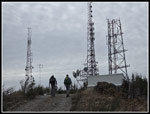
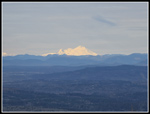
We soon came out on the road from Tiger Summit to Tiger 1 and 2. We would walk a section of this road later. For now it was time to head up the Poo Top Trail. We all mentioned how difficult it used to be to find the trail across the road. It as very indistinct at first. Now there is a sign and the trail is easy to find. This follows the narrow ridge up to the summit of Tiger 1. It is steep in places. After snow in recent weeks our entire route was snow free this day. After constant climbing we were slowing down on this section. The trail finally dropped and then turned left heading for the summit. The old Poo Top reached the summit road right at the gate to the towers. Since the summit was clearcut, it now reaches a junction below the summit. Right is the Preston Trail that does go to the top. Left is a newer trail that cuts around the summit and pops out a the Hikers Hut. We went right and on up to the top. At the ridge top road we could see Mt. Rainier again and to the northeast Mt. Baker had bright sunlight on the lower half. We went up to the open gate and turned around. A worker was working on the tower. He was just "hanging out" part way up the tower.
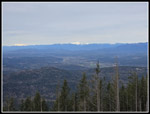
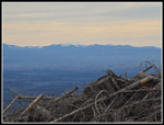
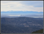
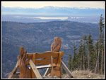
We retraced our steps and continued around Tiger 1 to the Hikers Hut. There was some wind on the east side but it was pretty calm on the west side of the top. We had another food and water break on the old bench. There is a newer bench but it does not have as good a view. It was 2:29 when we stopped. We had 3:30 to go until sunset but we had only covered 5 miles of an eventual 10.7. Our break was once again shorter than we would have liked. Mt. Rainier was right in front of us. Some camp robber jays kept us company. At 2:47 pm we headed down. A trail is under-construction alongside the steep road drop on the way to Tiger 2. For now we still walk the road. It is very steep. During our 14 years of headlamp hikes we went down it with icy snow wearing microspikes many times. We did have Tiger 2 and Seattle plus the Olympic Mountains in view. We also had some bright afternoon sunshine lighting up Mt. Baker. The 200' gain would be the longest of our remaining uphills sections. The wind was blowing much harder now but it was mostly behind us.
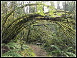
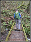
Our stop atop Tiger 2 was short. We enjoyed the views and took a few photos before heading on. The road over to Tiger 3 is much less steep than the road between 1 and 2. Down we went then we had a short climb to the top of Tiger 3. I was atop Tigers 2 and 3 just four days earlier. That day was much colder. The trail down from Tiger 3 is one we have hiked many times together. Mostly that has been on our headlamp hikes. This day we still had plenty of daylight left. We headed down at 3:25 pm. We saw some hikers on the trial down but not a lot. When we reached the Talus Rocks Trail it was time to turn left. Instead of the gently descending old road/trail we chose another uphill segment. It was just the thing for tired legs. There is a narrow tall waterfall along the way. It is dry most of the year and has some water in the winter. It had much more than usual today. Beyond that are the Talus Rocks. The trail winds between several big mossy rocks. We usually see it in the dark. Today it was light.
Instead of taking the Nook Trail down we chose to go over to the Section Line Trail. That trail is very steep above the junction but much gentler below. It was a pleasant part of the descent. At the bottom we could have taken The Wetland Trail which is pretty flat. Instead we took the Adventure Trail with a steep 160' ascent. That was our last climb of the day. From the top is was downhill to the Wetland Trail. We were soon heading down from the Tradition Plateau to the Sunset Trailhead in Issaquah. After not seeing many people while coming down, three groups finished right behind us. It was 5:43 at the finish. That was 6 minutes before sunset. In just another eleven days Daylight Saving Time will begin and we will gain an hour of evening daylight.
This turned out to be a really fun hike. I especially like one way hikes. In this case we had a fairly short drive back to my car. Short but in Issaquah rush hour traffic it was not speedy. We had sunshine and blue sky early turning to almost completely cloud covered in the later afternoon. We had more hiking above 50F than we have had in months. The Chirico Trail is busy most every day but most of our route was not. We definitely made the most of daylight as we finished right before it ended. Mountain views were pretty good from the clearcut summits, especially Mt. Rainier, Mt. Baker, and the Olympics. It was as good leg stretcher at 10.7 miles and 3600' of elevation gain. That was the most elevation gain I have had since 4200' summiting Navaho Peak on October 12, 2024. For the five days since Saturday I hiked 27 miles with 7700' of gain. So much for a slow February. Actually, I had only 18 miles and 2600' of gain at the half-way point of the month. I will finish with 70 miles and 15,800' of gain. A very poor month turned into an average one. All in all, it was a great day to leave work early and get in a nice long hike.
Click on thumbnails to get
larger pictures.
Trips - 2025
Home
We quickly headed up to the higher point. I expected to see parasailors as we actually had some warmer air thermals. We did not see any at all. We had a longer break at the picnic table at the highest point. The sunshine felt really good. We arrived at 12:25 pm and stayed until 12:42 pm. We could have stayed much longer but we still had a long way to go. Once out of the sun it was much cooler though not cold. We headed over to what is now the bottom of the One View Trail. The trail over is only a few years old. A short climb brought us to the railroad grade intersection. The old trail to Poo Poo Point went off to the right here. It has been obliterated. We went straight ahead and uphill on the One View Trail. There are some ups and downs as the trial climbs the spine of the ridge. We passed Fifteen Mile Gap and then climbed to meet the Tiger Mountain Trail (TMT). We went right on the TMT to the Hidden Forest Trail. Now came one of the steepest sections of the day. It is steep but not very long. A big tree fell here and we had to pass along the side of it to get by.
We soon came out on the road from Tiger Summit to Tiger 1 and 2. We would walk a section of this road later. For now it was time to head up the Poo Top Trail. We all mentioned how difficult it used to be to find the trail across the road. It as very indistinct at first. Now there is a sign and the trail is easy to find. This follows the narrow ridge up to the summit of Tiger 1. It is steep in places. After snow in recent weeks our entire route was snow free this day. After constant climbing we were slowing down on this section. The trail finally dropped and then turned left heading for the summit. The old Poo Top reached the summit road right at the gate to the towers. Since the summit was clearcut, it now reaches a junction below the summit. Right is the Preston Trail that does go to the top. Left is a newer trail that cuts around the summit and pops out a the Hikers Hut. We went right and on up to the top. At the ridge top road we could see Mt. Rainier again and to the northeast Mt. Baker had bright sunlight on the lower half. We went up to the open gate and turned around. A worker was working on the tower. He was just "hanging out" part way up the tower.
We retraced our steps and continued around Tiger 1 to the Hikers Hut. There was some wind on the east side but it was pretty calm on the west side of the top. We had another food and water break on the old bench. There is a newer bench but it does not have as good a view. It was 2:29 when we stopped. We had 3:30 to go until sunset but we had only covered 5 miles of an eventual 10.7. Our break was once again shorter than we would have liked. Mt. Rainier was right in front of us. Some camp robber jays kept us company. At 2:47 pm we headed down. A trail is under-construction alongside the steep road drop on the way to Tiger 2. For now we still walk the road. It is very steep. During our 14 years of headlamp hikes we went down it with icy snow wearing microspikes many times. We did have Tiger 2 and Seattle plus the Olympic Mountains in view. We also had some bright afternoon sunshine lighting up Mt. Baker. The 200' gain would be the longest of our remaining uphills sections. The wind was blowing much harder now but it was mostly behind us.
Our stop atop Tiger 2 was short. We enjoyed the views and took a few photos before heading on. The road over to Tiger 3 is much less steep than the road between 1 and 2. Down we went then we had a short climb to the top of Tiger 3. I was atop Tigers 2 and 3 just four days earlier. That day was much colder. The trail down from Tiger 3 is one we have hiked many times together. Mostly that has been on our headlamp hikes. This day we still had plenty of daylight left. We headed down at 3:25 pm. We saw some hikers on the trial down but not a lot. When we reached the Talus Rocks Trail it was time to turn left. Instead of the gently descending old road/trail we chose another uphill segment. It was just the thing for tired legs. There is a narrow tall waterfall along the way. It is dry most of the year and has some water in the winter. It had much more than usual today. Beyond that are the Talus Rocks. The trail winds between several big mossy rocks. We usually see it in the dark. Today it was light.
Instead of taking the Nook Trail down we chose to go over to the Section Line Trail. That trail is very steep above the junction but much gentler below. It was a pleasant part of the descent. At the bottom we could have taken The Wetland Trail which is pretty flat. Instead we took the Adventure Trail with a steep 160' ascent. That was our last climb of the day. From the top is was downhill to the Wetland Trail. We were soon heading down from the Tradition Plateau to the Sunset Trailhead in Issaquah. After not seeing many people while coming down, three groups finished right behind us. It was 5:43 at the finish. That was 6 minutes before sunset. In just another eleven days Daylight Saving Time will begin and we will gain an hour of evening daylight.
This turned out to be a really fun hike. I especially like one way hikes. In this case we had a fairly short drive back to my car. Short but in Issaquah rush hour traffic it was not speedy. We had sunshine and blue sky early turning to almost completely cloud covered in the later afternoon. We had more hiking above 50F than we have had in months. The Chirico Trail is busy most every day but most of our route was not. We definitely made the most of daylight as we finished right before it ended. Mountain views were pretty good from the clearcut summits, especially Mt. Rainier, Mt. Baker, and the Olympics. It was as good leg stretcher at 10.7 miles and 3600' of elevation gain. That was the most elevation gain I have had since 4200' summiting Navaho Peak on October 12, 2024. For the five days since Saturday I hiked 27 miles with 7700' of gain. So much for a slow February. Actually, I had only 18 miles and 2600' of gain at the half-way point of the month. I will finish with 70 miles and 15,800' of gain. A very poor month turned into an average one. All in all, it was a great day to leave work early and get in a nice long hike.
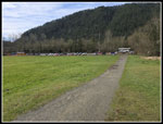 Chirico Trailhead |
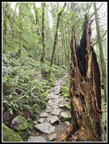 Rocky Trail |
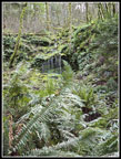 Waterfall Above |
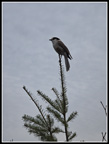
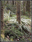 Woodpecker |
 Mt. Rainier |
 Looking NW From PPP |
 Folks At Poo Poo Point |
 Green Arches |
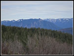 Mts. Si & Teneriffe |
 West Rattlesnake Mt. |
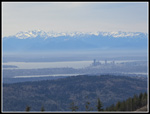 Seattle & Olympic Mts. |
 Tiger 2 |
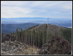
 Tiger 1 Summit |
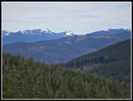
 Three Fingers Mt. |
 Rainier & White Clouds |
 Mt. St. Helens |
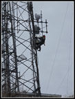 Tower Worker |
 Camp Robber Jay |
 Cloudier Mt. Rainier |
 View To The West |
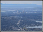 Bellevue |
 Lit Up Mt. Baker |
 Tiger 3 Bench |
 Busted Bridge |
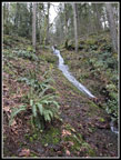 Narrow Waterfall |
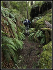 Gary & Talus Rocks |
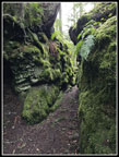 Gap In The Rocks |
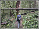 Log Over Trail |
Trips - 2025
Home