01-25-25
It
had not snowed in weeks and it was very cold. That meant hard packed
icy tracks in the mountains. I wanted a close in trip that would not be
too strenuous as I had another hike planned for Sunday. I have done the
Issaquah Alps to death this fall and winter and wanted something
different. That brought Lord Hill to mind. I knew about the trails for
many years before my first visit in 2018. I followed up with trips in
2019 and 2020. I had not been back since then. I wanted to get on the
way early but did not get out of the house until about 7:40 am. I
managed to mess out the roundabout and ended up back on the highway. It
was 24 degrees in Monroe and when I finally arrived at the trailhead it
was 22F. The lot was full though there was still plenty of room to park
on the side of the dirt road leading into the lot. I was on my way at
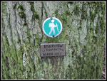
about 8:47 am. I walked to the trail only to find that it was closed
permanently. All these folks did not come here to not hike so I asked
another hiker and was told the start had moved to just off the entrance
road. The Boardwalk Trail is no more and the new start is on the
Entrance Trail. I was on the trail at 8:51 am. That is one of the
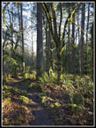
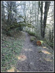
latest starts I can recall in years. The trail starts by descending.
The parking lot is one of the higher points in the park. The cold
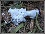
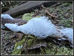
temperatures have led to lots of hair ice. It only occurs in
sub-freezing temperatures. I saw it on my mid-week after work hike on
Tiger Mountain. In the first two minutes I saw some very nice
specimens.
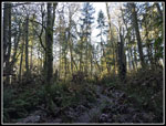
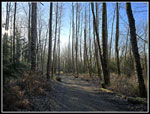
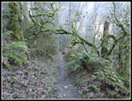
The trail soon reaches an old road near the bottom of the old Boardwalk Trail. There are a lot of trails in the park. I had tracks from my earlier trips on my phone GPS and that helped with navigation. I planned a counterclockwise loop hike. About 8 miles would be a good workout and not tire me out for the next day's hike. The highest point in the park is under 700' and the lowest is the Snohomish River at about 40'. Along with using trails I had hiked on previous trips I added in several new ones too. The trip took me on a dozen or more named trails. I had to keep checking the GPS as junction kept coming up. It was nice to hike where I did not have all the trails memorized.
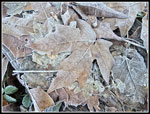
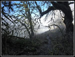
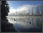
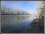
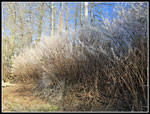
It was very cold at first. All the puddles were frozen over. All the lakes/ponds were frozen. I had on light gloves that allowed me to operate my phone/camera. It also left me with cold hands much of the day. I saw two runners early and then again later. I saw very few people until I reached the Pipeline Trail well over half way through my trip. After dropping from the trailhead, I ascended trails in the northwest corner of the park. After that, I descended to the Snohomish River. In the first half mile I saw several good patches of hair ice. After that I only saw it in a few places. I reached the river at 10:22 am. There was a little fog over the river making it look like smoke on the water. This provided some interesting photos. It was really cold on the beach/shore. A little downriver the sun was shining on the shore. I headed for it. It was much warmer in the sunshine. I really was not in a hurry to leave. I still had a lot to see so my viist was short. Coming down the trail, I saw a hiker turning onto a trail heading upriver. On my way back I decided to take that trail. It took me farther south than I have been previously.
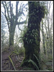
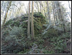
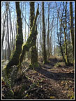
The trail climbed steeply then leveled off. A short way farther is a viewpoint down to the river. The sun was low enough to make it hard to see anything but the glare. I did see someone fishing in the river. Surprisingly, I could hear him talking though he was quite a distance away. I looked at my phone GPS map and figured out where I wanted to go next. The trail took me to Beaver Lodge Pond. It was frozen over. I did not see any signs of beaver work. I took the trail around the right side of the lake. I walked right by it at first but realized my mistake and found it. This was the Midway Trail. It is for hikers only. I crossed it several more times on my trip after I left it. This narrow trail had a few creek crossings on icy rocks and some very hard frozen mud. It will be much muddier when the temperature stays above freezing. My low top hiking shoes were fine with the mud all frozen. I found some great spots with lots of hanging moss on the trees. The low sun backlit in places. That made for more good photos.
The trail brought me to the Main Trail. The Midway Trail crossed over the Main Trail and kept going up the slope. I turned right and quickly reached the Pipeline Trail. The Pipeline Trail is over a pipeline from Canada south through the Seattle area. It is wide enough that the sun was shining on it. No more frozen forest hiking. Now I had a little sunshine. It was 11:15 am when I took off my pack and had lunch in the middle of the trail. I had not seen anyone in at least an hour. I saw nobody during my on trail break. A short climb brought me to the trail to Temple Pond 1. I still have not seen Temple Pond 2 on my maps. I reached the pond to find nobody there. The big pond was frozen over. I soon retraced my steps to the Pipeline Trail and ascended a short steep section to another flat spot. This is where the trail to the Viewpoint starts.There was a big group of nearly a dozen hikers there. I was afraid they were heading for the Viewpoint. They were not. Just a few minutes later I turned off the trail for the very short spur trail to the Viewpoint.
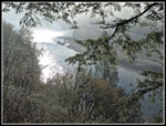
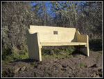
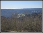
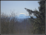
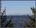
I arrived at the Viewpoint to find no people and a lot of sunshine. I could see a pale Mt. Rainier with a lenticular cloud over it. This usually signals a change to rainy weather but it was not correct this time. I also could see the Olympic Mountains. They were much less hazy. After a long break on the nice bench, I went over to the other viewpoints. These are small spots with views over to the Cascade Mountains. I was not good at guessing most of the peaks in sight. At home, I was able to name most of them with a little Internet help. At left was a very snowy Vesper Peak. It is far down the Mountain Loop Highway and I was very surprised to see the side a don't usually see. It appeared much closer than expected. Glacier Peak was right next to it. Farther along were Mt. Stickney, Gunn, Gunnshy, Merchant and other Wild Sky peaks. The top of Mt. Index was visible to the right. It was nice to see these peaks from an angle I almost never see.
From the Viewpoint I planned a zigzagging route back to the trailhead. It included more than half a dozen more trails. I took one more turn back to the Pipeline Trail to get my mileage up to a full eight miles. In the last mile I began to see more people. There were several families with kids out for a forest hike. I finally reached the end of the trip at 12:50 pm. I spent just a minute short of 4 hours on the trail. My speed including breaks was 2 mph. My hiking time was 2.4 mph. It was warm enough in the sunshine to take longer than normal breaks. It was so cold when I went back into the forest. It did warm up to 37F back at the trailhead. That was 15 degrees warmer than the start but still pretty cold. With the hair ice, frozen bushes, foggy river, and great views from the Viewpoint I ended up with nearly 200 photos. That also slowed me down.
It was a great day for a very low elevation hike. Most trailheads on Tiger Mt. are nearly as high as the highest point in Lord Hill Park. The lack of people in this popular park was surprising. The lot was nearly full in the morning. In the afternoon the road in was lined with cars too. I had hiked here in spring with wildflowers and in fall with mushrooms and colorful leaves. This was my first time in winter. Having the bud frozen was quite helpful. For the day I hiked 8 miles with about 1000' of elevation gain. There were many short ups and downs and I am not sure my GPS was able to log them all. It felt like more than 1000' of elevation gain. The sunshine was unusual for January and largely offset the well below temperatures. As I said, it was a great day for a hike.
Click on thumbnails to get
larger pictures.
Trips - 2025
Home
The trail soon reaches an old road near the bottom of the old Boardwalk Trail. There are a lot of trails in the park. I had tracks from my earlier trips on my phone GPS and that helped with navigation. I planned a counterclockwise loop hike. About 8 miles would be a good workout and not tire me out for the next day's hike. The highest point in the park is under 700' and the lowest is the Snohomish River at about 40'. Along with using trails I had hiked on previous trips I added in several new ones too. The trip took me on a dozen or more named trails. I had to keep checking the GPS as junction kept coming up. It was nice to hike where I did not have all the trails memorized.
It was very cold at first. All the puddles were frozen over. All the lakes/ponds were frozen. I had on light gloves that allowed me to operate my phone/camera. It also left me with cold hands much of the day. I saw two runners early and then again later. I saw very few people until I reached the Pipeline Trail well over half way through my trip. After dropping from the trailhead, I ascended trails in the northwest corner of the park. After that, I descended to the Snohomish River. In the first half mile I saw several good patches of hair ice. After that I only saw it in a few places. I reached the river at 10:22 am. There was a little fog over the river making it look like smoke on the water. This provided some interesting photos. It was really cold on the beach/shore. A little downriver the sun was shining on the shore. I headed for it. It was much warmer in the sunshine. I really was not in a hurry to leave. I still had a lot to see so my viist was short. Coming down the trail, I saw a hiker turning onto a trail heading upriver. On my way back I decided to take that trail. It took me farther south than I have been previously.
The trail climbed steeply then leveled off. A short way farther is a viewpoint down to the river. The sun was low enough to make it hard to see anything but the glare. I did see someone fishing in the river. Surprisingly, I could hear him talking though he was quite a distance away. I looked at my phone GPS map and figured out where I wanted to go next. The trail took me to Beaver Lodge Pond. It was frozen over. I did not see any signs of beaver work. I took the trail around the right side of the lake. I walked right by it at first but realized my mistake and found it. This was the Midway Trail. It is for hikers only. I crossed it several more times on my trip after I left it. This narrow trail had a few creek crossings on icy rocks and some very hard frozen mud. It will be much muddier when the temperature stays above freezing. My low top hiking shoes were fine with the mud all frozen. I found some great spots with lots of hanging moss on the trees. The low sun backlit in places. That made for more good photos.
The trail brought me to the Main Trail. The Midway Trail crossed over the Main Trail and kept going up the slope. I turned right and quickly reached the Pipeline Trail. The Pipeline Trail is over a pipeline from Canada south through the Seattle area. It is wide enough that the sun was shining on it. No more frozen forest hiking. Now I had a little sunshine. It was 11:15 am when I took off my pack and had lunch in the middle of the trail. I had not seen anyone in at least an hour. I saw nobody during my on trail break. A short climb brought me to the trail to Temple Pond 1. I still have not seen Temple Pond 2 on my maps. I reached the pond to find nobody there. The big pond was frozen over. I soon retraced my steps to the Pipeline Trail and ascended a short steep section to another flat spot. This is where the trail to the Viewpoint starts.There was a big group of nearly a dozen hikers there. I was afraid they were heading for the Viewpoint. They were not. Just a few minutes later I turned off the trail for the very short spur trail to the Viewpoint.
I arrived at the Viewpoint to find no people and a lot of sunshine. I could see a pale Mt. Rainier with a lenticular cloud over it. This usually signals a change to rainy weather but it was not correct this time. I also could see the Olympic Mountains. They were much less hazy. After a long break on the nice bench, I went over to the other viewpoints. These are small spots with views over to the Cascade Mountains. I was not good at guessing most of the peaks in sight. At home, I was able to name most of them with a little Internet help. At left was a very snowy Vesper Peak. It is far down the Mountain Loop Highway and I was very surprised to see the side a don't usually see. It appeared much closer than expected. Glacier Peak was right next to it. Farther along were Mt. Stickney, Gunn, Gunnshy, Merchant and other Wild Sky peaks. The top of Mt. Index was visible to the right. It was nice to see these peaks from an angle I almost never see.
From the Viewpoint I planned a zigzagging route back to the trailhead. It included more than half a dozen more trails. I took one more turn back to the Pipeline Trail to get my mileage up to a full eight miles. In the last mile I began to see more people. There were several families with kids out for a forest hike. I finally reached the end of the trip at 12:50 pm. I spent just a minute short of 4 hours on the trail. My speed including breaks was 2 mph. My hiking time was 2.4 mph. It was warm enough in the sunshine to take longer than normal breaks. It was so cold when I went back into the forest. It did warm up to 37F back at the trailhead. That was 15 degrees warmer than the start but still pretty cold. With the hair ice, frozen bushes, foggy river, and great views from the Viewpoint I ended up with nearly 200 photos. That also slowed me down.
It was a great day for a very low elevation hike. Most trailheads on Tiger Mt. are nearly as high as the highest point in Lord Hill Park. The lack of people in this popular park was surprising. The lot was nearly full in the morning. In the afternoon the road in was lined with cars too. I had hiked here in spring with wildflowers and in fall with mushrooms and colorful leaves. This was my first time in winter. Having the bud frozen was quite helpful. For the day I hiked 8 miles with about 1000' of elevation gain. There were many short ups and downs and I am not sure my GPS was able to log them all. It felt like more than 1000' of elevation gain. The sunshine was unusual for January and largely offset the well below temperatures. As I said, it was a great day for a hike.
 Perfect Hair Ice |
 More Hair Ice |
 Frozen Leaves |
 Forest Still Shady |
 Sunlight Arrives |
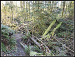
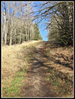
 Road/Trail |
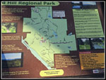 Park Info Board |
 Frosted Tree |
 Mossy Arch |
 Mist & Mossy Arch |
 Ferns On Trees |
 Near The River |
 Looking Upriver |
 Looking Downriver |
 White Bushes |
 String Webbing |
 Hiking Signs |
 Fern Covered Rock |
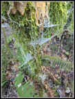 More String Webs |
 Fisherman In The River |
 Moss & Frost |
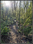
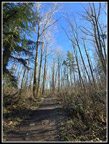
 New Trail |
 Frozen Beaver Lodge Pond |
 Midway Trail |
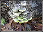 Colorful Fungi |
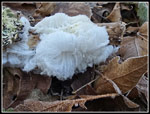 More Hair Ice |
 Wood Plank Bridge |
 Sunlit Mossy Trees |
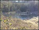 Frozen Crossroad Pond |
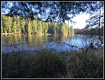 Temple Pond |
 More Mossy Trees |
 Pipeline Trail |
 Viewpoint Bench |
 Viewpoint View South |
 Mt. Rainier |
 Olympic Mountains |
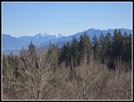 Wild Sky Peaks |
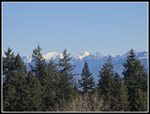 Vesper & Glacier Peak |
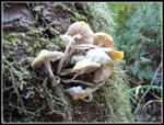 Nice Mushrooms |
 Tall Trees |
Trips - 2025
Home