02-23-25
A
big atmospheric river was focused on Western Washington. Saturday was
supposed to rain hard with flood warnings all day. It did not I got out
early for a 9 miles dry hike before the rain arrived in the afternoon.
Sunday looked to be much worse. Hard rain all day long. This was
disappointing news. In the late 1980 I hiked the Tiger Mountain Trail
from what was the start off the West Side Road near Otter Lake. The
trail now starts at the Tiger Mountain Road some four plus miles
farther south. I used to drive to Tiger Summit and then along the road
to the trailhead. I parked right alongside the road. There was no
parking lot. About .40 miles up the trail was a boot path to the right
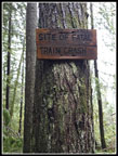
at a switchback left. It very quickly arrived at Holder Creek, the site
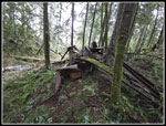
of a 1925 trail wreck in which the trail jumped the track on the
trestle over the creek. The locomotive was recovered but the remains of
trail cars remained. I found bits and pieces of the wreck 35+ years
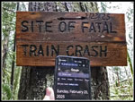
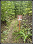
ago. For years their has been a sign reading "2/23/25 SITE OF FATAL
TRAIN CRASH". A few years ago I realized just how close to 100 years
ago the wreck occurred. Last year Gary and I visited and after that I
marked my calendar for the Centennial. Then came the atmospheric river
and all the hard rain. I was not enthused to hike 9 miles from the new
end of the TMT. I figured this historic even would not see my visiting.
Back on July 4, 1989 I hiked to Poodle Dog Pass for the Centennial of
the discovery of gold near Monte Cristo. The ore bearing slopes were
seen from near the pass. I do like hiking related history.
The forecast was so bad the night before that I planned to get up at 6:00 am, take a look at the conditions and probably go back to bed. Hard rain and high winds did not sound like much fun. I woke up and 6:00 am and fell back asleep until 7:00 am. I got up and checked the weather. 99% chance of hard rain at 10:30 pm now showed no rain at all on the Doppler radar. How could they be so wrong so recently? Now the rain looked to be starting at about 10:00 am at the wreck site. Within 35 minutes I was out the door and on my way. It is 2.4 miles each way to the wreck site on the Iverson Railroad Trail. I made very good time on the drive. Dry in Seattle turned to rain in Issaquah. I kept up until about a mile from Tiger Summit where it stopped entirely. As I drove from the highway to the inner parking lot I saw the gate on the West Side Road was open and a bunch of brightly dressed people were milling around. A bunch of cars were parked just after the gate. What was going on? I parked at 8:10 am
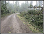
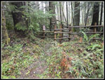
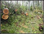
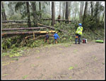
Even with the awful weather forecast there were a dozen or so cars in the lot. I put on my rain jacket and headed for the Iverson Railroad. We had a big windstorm in late November. A lot of trees came down across a lot of trail. Gary and I spent a full day cutting them out along with a lot of volunteers. The Iverson Railroad was especially hit hard. Recently a section of the trail was logged on its east side. That border is where a wind hits as lot of trees and many fall on the trail. It was listed as closed a month after the storm. It is a popular bike trail and I expected it would be cleared out three months after the storm. Especially since it starts right at the parking lot. I was wrong. It was signed closed and plastic tape blocked the start. My first inclination was to try it anyway. I went around the tape and started up the trail. Some logs were cut out immediately. Within a couple minutes I stopped. If I continued on and ran into jackstrawed pile of hundred foot tall trees with rootballs out of the ground I might not make it through. I might also waste so much time that the full storm would be on me before I could take another route.
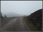
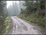
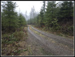
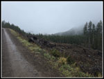
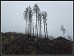
Before the Iverson Trail was built I used to drive the road and then hike it when it was gated. It had been 20+ years since I had walked the road but it seemed like the best idea this day. I went back to the parking lot and onto the road, passing my car at 8:18 am.. The group I saw earlier was now getting ready to go somewhere I walked around the dozens of people and asked what was going on. It was a WTA sawyer certification outing. Lots of folks get trained to cut out all the trees that fall every year. Washington Trails Association is one of the groups that train and then use the now skilled volunteers. I zoomed on by the group and down the road. The road was much hillier than I recalled. There were several good sized ups and downs. Part of the way was through the newer clearcuts. I made very good time on the road. I was really surprised to catch and pass two other hikers. I passed the old end of the Iverson Railroad. A newer trail leaves the Iverson and continues to the TMT at the wreck site. I was tempted to hike this route but it might have down trees. I continued on the road.
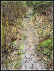
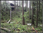
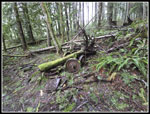
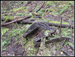
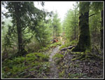
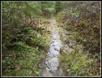
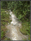
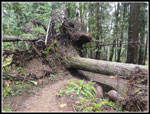
Another old logging road turns off the West Side Road. It intersects the trail to the wreck. That trail can be brushy so I stayed on the main road. At about 1.9 miles from the parking lot I reached the turnoff for the TMT. Logging on Middle Tiger has obliterated part of the TMT until logging is done and the trail is rebuilt. The TMT is officially closed right at the wreck site. Now I just had .40 miles to go. There was still no sign of any rain. At first there were many logs cut out. This section has been cleared since the big windstorm. In places the trail was a creek. Two small trees were leaning across the trail and I had to almost kneel down to get under them. I reached the site at 8:59 am. I took 45 minutes to hike 2.3 miles. I took photos of the sign along with the time and date from my phone. It was 100 years to the day when the wreck occurred. I realized that I was born at a time closer to the wreck than today. I also took two videos of the sign and a walk through the remains of the wreckage. By 9:14 I was ready to leave. I did not have a phone signal at the site. Part way down the trail I was able to upload a photo to the Internet.
I headed down the trail to the road. At the road I found a couple trucks and some students working on sawyer certification. I was in good shape to make it most of the way back to the car before the storm hit. At the old logging road that goes up to the trail to the wreck site I decided to head up and get in a little more elevation gain. I walked the road up to the where the trail cuts across it. I could head back down the road or I could take the trail. It meets the Iverson Railroad well before the trail section along the edge of the clearcut. It was likely not obliterated by fallen trees. I chose to try the trail. It was in good shape. One big tree fell just slightly upstream from a bridge. The big tree was suspended above the creek. In another place a tree fell over across the trail. The entire rootball rose 15 feet tall. At the trail the gap under the log was only about two feet. Next to that was a low spot where hikers were getting through. That worked fine. At the junction where the Old Iverson Railroad drops to the West Side Road I stopped to check for an Internet connection. I finally found a weak signal. I was able to check Doppler radar to see how close the rainstorm was now. It wasn't. It wasn't anywhere near me. I called Gary and verified that the rain was now forecast to hold of for another couple hours. A group of six runners zoomed by me here. They were only the second group of non-WTA folks I had seen.
I thanked Gary and headed down to the road. Now I had to think about what else I might do. With my detour, it would be just over 5 miles total hiking back at the car. I could go farther now that the storm was not about to arrive. I hiked back to the car and headed for the Connector Trail. In .30 miles it took me to the East Side Road that goes up to Tiger 1, 2, and East Tiger. I headed up the road. At about a mile from the car is where the Predator bike trail crosses the road. I hike up to that point. Then it was downhill to the Connector and one last climb before reaching the parking lot. It was now 11:13 am and I was done for the day. My fast hike up the Iverson Railroad to the wreck site was supposed to be 4.8 miles round trip. I ended up with a different route and a 7 miles hike with 1200' of elevation gain. To top it off I had a dry drive all the way home. The rain did arrived several hours after that.
I had planned to hike to the Holder Creek Train Wreck site since last early summer. Then the big storm had me ready to miss the hike. Then I thought I could get in the trip with some rain. In reality I had a dry hike and then some more hiking. The bad weather did keep most folks at home. The parking lot was not even half full at the end of the trip. Like the centennial of gold at Monte Cristo, this trip was a centennial of a historical event that required a hike to see. Though I saw only a the two hikers and the six runners I did see a WTA trip report from another history buff who was at the site this day. Now that was a surprise.
Click on thumbnails to get
larger pictures.
Trips - 2025
Home
The forecast was so bad the night before that I planned to get up at 6:00 am, take a look at the conditions and probably go back to bed. Hard rain and high winds did not sound like much fun. I woke up and 6:00 am and fell back asleep until 7:00 am. I got up and checked the weather. 99% chance of hard rain at 10:30 pm now showed no rain at all on the Doppler radar. How could they be so wrong so recently? Now the rain looked to be starting at about 10:00 am at the wreck site. Within 35 minutes I was out the door and on my way. It is 2.4 miles each way to the wreck site on the Iverson Railroad Trail. I made very good time on the drive. Dry in Seattle turned to rain in Issaquah. I kept up until about a mile from Tiger Summit where it stopped entirely. As I drove from the highway to the inner parking lot I saw the gate on the West Side Road was open and a bunch of brightly dressed people were milling around. A bunch of cars were parked just after the gate. What was going on? I parked at 8:10 am
Even with the awful weather forecast there were a dozen or so cars in the lot. I put on my rain jacket and headed for the Iverson Railroad. We had a big windstorm in late November. A lot of trees came down across a lot of trail. Gary and I spent a full day cutting them out along with a lot of volunteers. The Iverson Railroad was especially hit hard. Recently a section of the trail was logged on its east side. That border is where a wind hits as lot of trees and many fall on the trail. It was listed as closed a month after the storm. It is a popular bike trail and I expected it would be cleared out three months after the storm. Especially since it starts right at the parking lot. I was wrong. It was signed closed and plastic tape blocked the start. My first inclination was to try it anyway. I went around the tape and started up the trail. Some logs were cut out immediately. Within a couple minutes I stopped. If I continued on and ran into jackstrawed pile of hundred foot tall trees with rootballs out of the ground I might not make it through. I might also waste so much time that the full storm would be on me before I could take another route.
Before the Iverson Trail was built I used to drive the road and then hike it when it was gated. It had been 20+ years since I had walked the road but it seemed like the best idea this day. I went back to the parking lot and onto the road, passing my car at 8:18 am.. The group I saw earlier was now getting ready to go somewhere I walked around the dozens of people and asked what was going on. It was a WTA sawyer certification outing. Lots of folks get trained to cut out all the trees that fall every year. Washington Trails Association is one of the groups that train and then use the now skilled volunteers. I zoomed on by the group and down the road. The road was much hillier than I recalled. There were several good sized ups and downs. Part of the way was through the newer clearcuts. I made very good time on the road. I was really surprised to catch and pass two other hikers. I passed the old end of the Iverson Railroad. A newer trail leaves the Iverson and continues to the TMT at the wreck site. I was tempted to hike this route but it might have down trees. I continued on the road.
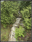
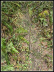
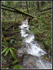
Another old logging road turns off the West Side Road. It intersects the trail to the wreck. That trail can be brushy so I stayed on the main road. At about 1.9 miles from the parking lot I reached the turnoff for the TMT. Logging on Middle Tiger has obliterated part of the TMT until logging is done and the trail is rebuilt. The TMT is officially closed right at the wreck site. Now I just had .40 miles to go. There was still no sign of any rain. At first there were many logs cut out. This section has been cleared since the big windstorm. In places the trail was a creek. Two small trees were leaning across the trail and I had to almost kneel down to get under them. I reached the site at 8:59 am. I took 45 minutes to hike 2.3 miles. I took photos of the sign along with the time and date from my phone. It was 100 years to the day when the wreck occurred. I realized that I was born at a time closer to the wreck than today. I also took two videos of the sign and a walk through the remains of the wreckage. By 9:14 I was ready to leave. I did not have a phone signal at the site. Part way down the trail I was able to upload a photo to the Internet.
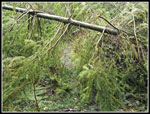
I headed down the trail to the road. At the road I found a couple trucks and some students working on sawyer certification. I was in good shape to make it most of the way back to the car before the storm hit. At the old logging road that goes up to the trail to the wreck site I decided to head up and get in a little more elevation gain. I walked the road up to the where the trail cuts across it. I could head back down the road or I could take the trail. It meets the Iverson Railroad well before the trail section along the edge of the clearcut. It was likely not obliterated by fallen trees. I chose to try the trail. It was in good shape. One big tree fell just slightly upstream from a bridge. The big tree was suspended above the creek. In another place a tree fell over across the trail. The entire rootball rose 15 feet tall. At the trail the gap under the log was only about two feet. Next to that was a low spot where hikers were getting through. That worked fine. At the junction where the Old Iverson Railroad drops to the West Side Road I stopped to check for an Internet connection. I finally found a weak signal. I was able to check Doppler radar to see how close the rainstorm was now. It wasn't. It wasn't anywhere near me. I called Gary and verified that the rain was now forecast to hold of for another couple hours. A group of six runners zoomed by me here. They were only the second group of non-WTA folks I had seen.
I thanked Gary and headed down to the road. Now I had to think about what else I might do. With my detour, it would be just over 5 miles total hiking back at the car. I could go farther now that the storm was not about to arrive. I hiked back to the car and headed for the Connector Trail. In .30 miles it took me to the East Side Road that goes up to Tiger 1, 2, and East Tiger. I headed up the road. At about a mile from the car is where the Predator bike trail crosses the road. I hike up to that point. Then it was downhill to the Connector and one last climb before reaching the parking lot. It was now 11:13 am and I was done for the day. My fast hike up the Iverson Railroad to the wreck site was supposed to be 4.8 miles round trip. I ended up with a different route and a 7 miles hike with 1200' of elevation gain. To top it off I had a dry drive all the way home. The rain did arrived several hours after that.
I had planned to hike to the Holder Creek Train Wreck site since last early summer. Then the big storm had me ready to miss the hike. Then I thought I could get in the trip with some rain. In reality I had a dry hike and then some more hiking. The bad weather did keep most folks at home. The parking lot was not even half full at the end of the trip. Like the centennial of gold at Monte Cristo, this trip was a centennial of a historical event that required a hike to see. Though I saw only a the two hikers and the six runners I did see a WTA trip report from another history buff who was at the site this day. Now that was a surprise.
 I'm On The Cloudy Road |
 Hikers Ahead! |
 Muddy Creek |
 Lots Of Trees Down |
 Onto The TMT |
 Trees Fell On Trail |
 Old Logging Cable |
 Time To Duck! |
 The Trail Is A Creek |
 Train Wreck Site |
 100 Years Later |
 Old Rusty Train Car |
 Train Trestle Site |
 Old Train Wheels |
 More Parts |
 Back On TMT |
 Swiftly Flowing Trail |
 WTA Sawyers |
 TMT Connector Trail |
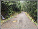
 Road I Ascended |
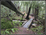 Tree Just Missed Bridge |
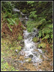
 Roaring Creek |
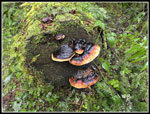 Nice Fungi Colors |
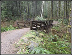
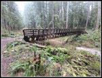 Big Bike Bridge |
 More Muddy Water |
 Time To duck Under |
 It's Still Cloudy |
 Trees Stand Out |
 Heading Out Again |
 More Running Water |
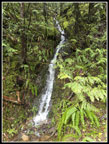 Small Waterfall |
 Heading Back To TH |
Trips - 2025
Home