10-08-25
The
good weather was about to end. Gary just returned from three weeks in
Europe. We needed to get in a fall color hike fast. Wildfire smoke was
still a problem east of the crest and the Teanaway was still on fire. I
thought of a trail I had not yet hiked. It turns out Gary had only
hiked it once. Lake Valhalla from Stevens Pass won out. A larch trip
would have been nice but a shorter drive, good air, and no crazy crowds
put this one at the top of the list. We also had the option of
continuing on to ascend Mt. McCausland. We did it twice together in
winter via Smith Brook Road. In the summer most people take the shorter
Smith Brook access to the Pacific Crest Trail (PCT) rather than the
longer route from Stevens Pass. It would give us more miles and fewer
people. I took the day off work and we headed out on Wednesday morning.
The days are getting shorter and morning traffic is a mess so we left
early meeting at the Bothell Park & Ridge at 6:25 am. I drove
to Stevens Pass. We were early enough to miss most of the traffic. We
did do part of the drive in the dark.
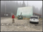
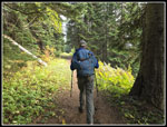
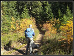
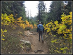
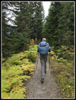
We arrived at the trailhead at about 7:45 am. It was 39 degrees. We also drove into the clouds and had no sunshine. We packed up and were on our way at 7:51 am. I have hiked the PCT south from Stevens several times. This was my first time northbound. The route starts off on the original Great Northern railroad grade over Stevens Pass, built in 1893. It was replaced with a tunnel in 1900 and that was replaced with the existing tunnel in 1929. The trade is a very gentle descent. It is smooth and makes for very fast hiking. With the cold temperature we had to go fast to warm up. The highway runs parallel and can be heard for about 1.7 miles though there was not much traffic this morning. At that point the trail rounds a ridge and turns sharply left. The grade remains for a short distance. From the turn, trains went down a series of switchbacks to reach flatter ground. The grade around the corner is where the trains backed up before starting down the first switchback. From there on we were on dirt trail.
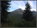
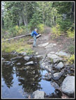
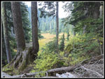
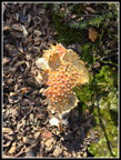
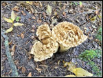
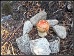
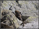
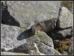
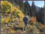
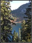
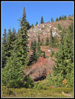
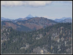
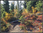
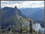
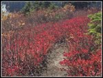
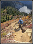
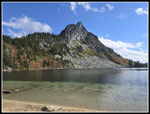
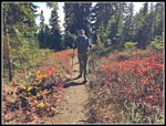
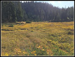
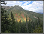
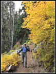
We had a look out in one spot and could see West Lichtenberg Mountain high above. The slope had some good red color. We were then back in the forest. Now the trail starts to climb though never steeply. We saw some mushrooms though not a lot. At about 2.8 miles we crossed into the Henry M. Jackson Wilderness. Soon forest gave way to some meadows with grasses and talus rocks. We crossed one creek soon after leaving the grade and another one near a meadow. Even after a long dry summer there was some running water. As we climbed again, we saw much of the day's mushrooms. One colorful amanita was right on the edge of the trail surrounded by small rocks. At a big rock field we stopped for a break. There were a bunch of pikas in the rocks and crossing the trail. I took half a dozen photos of them. It was an unexpected treat. Before we left, a hiker passed coming from the lake. He mentioned a bear down by the shore. The trail climbed up to a forested ridge top and dropped over the top. We soon saw Lake Valhalla through the trees. We came to one trail down but it was not the main one. Next was another big meadow. There were still some ripe blueberries to eat. At the main trail down to the lake we turned right and descended.
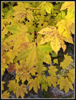
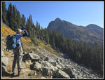
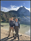
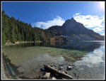
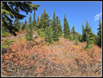
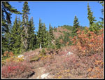
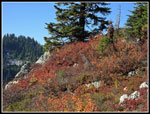
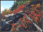
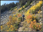
We found one group of women at the shore. The lake actually has a sandy beach. That is not something I often see in the mountains. We passed our of the clouds early in the hike and now had sunshine at the lake. We looked all around and did not see a bear. We reached the shore at 10:45 am. Gary recorded 5.7 miles. It was really nice sitting in the sunshine. It was much warmer than at the start. At 10:53 we headed back to the PCT. We both felt good and decided to go up McCausland. The Crest trail climbs up to a saddle between McCausland and Lichtenberg Mountain. We saw more people coming to the lake from the Smith Brook Trailhead. We saw a little fall color along here. At the saddle, the path up McCausland was unsigned but very obvious. We had half a mile to gain almost 700'. That is pretty steep. We climbed up the ridge on snowshoes in 2004 but I had never seen it without snow. There were some berries and more fall colors on the trip to the top. Near the bottom of the steepest part, we could see a couple hikers high above. It looked ridiculously steep. The actual trail is steep but has short switchbacks that make it much easier than it looked.
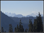
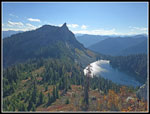
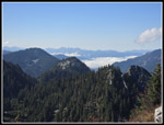
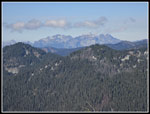
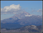
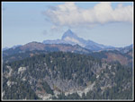
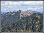
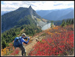
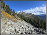
At the top of the steep spot we had an easy walk to the highest point on the summit ridge.Trees block much of the view north but we had great views in the other directions. Rock Mountain was easy to pick out. Lichtenberg Mountain no longer loomed high above us, it was just across the way. I had seen trip report photos of a big green summit register box. It was nowhere to be seen. At the far end of the ridge we had a partial view of Glacier Peak. Gary noticed the boot path leading into the trees. We took a closer look. A path dropped down along the narrow forested ridge. I went first and took a look. It dropped and then climbed a bit to a pile of rocks with terrific views to the north. Gary followed and we sat on the airy viewpoint. The big green register box is bolted to the rock. The drop off is quite impressive. We arrived at 11:54 am and stayed until 12:29 pm. The Monte Cristo peaks, Sloan, Pugh, Mt. Baker, Glacier Peak, and many more peaks were clearly in view. Just north we saw Jove Peak with forest on one side and meadows on the other.
We had a long way back to the car and finally headed back. The trip back to the lake was easy enough though slow on the steep descent. We were back at the lake at 1:33 pm. We enjoyed another stay but all too soon we headed back. It was not surprise that there were more groups on our second visit. We had some uphill back to the ridge top. Then it was downhill to the talus field crossing and uphill on that. We had a short water break or two on the way back. There were a few rocky spots but for the most part it is a very nice trail. After crossing the last creek we reached the start of the railroad grade and the gentle uphill climb back to Stevens Pass. After 12 miles we were getting a bit tired but kept up a pretty good pace. We arrived back at the car at 4:19 pm. The clouds were gone. On the PCT from the trailhead to Lake Valhalla we saw the guy who saw a bear. On the way back we saw a lone hiker. I think that is all we saw over about 11 miles. That's not bad for solitude. We saw hikers coming from Smith Brook but very few came the longer way. That provided a lot of solitude.
For the day we hiked. 13.4 miles with about 2800' of elevation gain. It is always a treat to hike a trail for the first time. We were familiar with Mt. McCausland but only under ten feet of snow. It was much different in the fall. Traffic did not prove to be a problem in either direction. We had some good fall colors, especially on McCausland. The lake and peak likely would have snow a few days laster but we had sunshine. I have had a month of good fall color hikes and Gary managed to get in one too.
Click on thumbnails to get
larger pictures.
Trips - 2025
Home
We arrived at the trailhead at about 7:45 am. It was 39 degrees. We also drove into the clouds and had no sunshine. We packed up and were on our way at 7:51 am. I have hiked the PCT south from Stevens several times. This was my first time northbound. The route starts off on the original Great Northern railroad grade over Stevens Pass, built in 1893. It was replaced with a tunnel in 1900 and that was replaced with the existing tunnel in 1929. The trade is a very gentle descent. It is smooth and makes for very fast hiking. With the cold temperature we had to go fast to warm up. The highway runs parallel and can be heard for about 1.7 miles though there was not much traffic this morning. At that point the trail rounds a ridge and turns sharply left. The grade remains for a short distance. From the turn, trains went down a series of switchbacks to reach flatter ground. The grade around the corner is where the trains backed up before starting down the first switchback. From there on we were on dirt trail.
We had a look out in one spot and could see West Lichtenberg Mountain high above. The slope had some good red color. We were then back in the forest. Now the trail starts to climb though never steeply. We saw some mushrooms though not a lot. At about 2.8 miles we crossed into the Henry M. Jackson Wilderness. Soon forest gave way to some meadows with grasses and talus rocks. We crossed one creek soon after leaving the grade and another one near a meadow. Even after a long dry summer there was some running water. As we climbed again, we saw much of the day's mushrooms. One colorful amanita was right on the edge of the trail surrounded by small rocks. At a big rock field we stopped for a break. There were a bunch of pikas in the rocks and crossing the trail. I took half a dozen photos of them. It was an unexpected treat. Before we left, a hiker passed coming from the lake. He mentioned a bear down by the shore. The trail climbed up to a forested ridge top and dropped over the top. We soon saw Lake Valhalla through the trees. We came to one trail down but it was not the main one. Next was another big meadow. There were still some ripe blueberries to eat. At the main trail down to the lake we turned right and descended.
We found one group of women at the shore. The lake actually has a sandy beach. That is not something I often see in the mountains. We passed our of the clouds early in the hike and now had sunshine at the lake. We looked all around and did not see a bear. We reached the shore at 10:45 am. Gary recorded 5.7 miles. It was really nice sitting in the sunshine. It was much warmer than at the start. At 10:53 we headed back to the PCT. We both felt good and decided to go up McCausland. The Crest trail climbs up to a saddle between McCausland and Lichtenberg Mountain. We saw more people coming to the lake from the Smith Brook Trailhead. We saw a little fall color along here. At the saddle, the path up McCausland was unsigned but very obvious. We had half a mile to gain almost 700'. That is pretty steep. We climbed up the ridge on snowshoes in 2004 but I had never seen it without snow. There were some berries and more fall colors on the trip to the top. Near the bottom of the steepest part, we could see a couple hikers high above. It looked ridiculously steep. The actual trail is steep but has short switchbacks that make it much easier than it looked.
At the top of the steep spot we had an easy walk to the highest point on the summit ridge.Trees block much of the view north but we had great views in the other directions. Rock Mountain was easy to pick out. Lichtenberg Mountain no longer loomed high above us, it was just across the way. I had seen trip report photos of a big green summit register box. It was nowhere to be seen. At the far end of the ridge we had a partial view of Glacier Peak. Gary noticed the boot path leading into the trees. We took a closer look. A path dropped down along the narrow forested ridge. I went first and took a look. It dropped and then climbed a bit to a pile of rocks with terrific views to the north. Gary followed and we sat on the airy viewpoint. The big green register box is bolted to the rock. The drop off is quite impressive. We arrived at 11:54 am and stayed until 12:29 pm. The Monte Cristo peaks, Sloan, Pugh, Mt. Baker, Glacier Peak, and many more peaks were clearly in view. Just north we saw Jove Peak with forest on one side and meadows on the other.
We had a long way back to the car and finally headed back. The trip back to the lake was easy enough though slow on the steep descent. We were back at the lake at 1:33 pm. We enjoyed another stay but all too soon we headed back. It was not surprise that there were more groups on our second visit. We had some uphill back to the ridge top. Then it was downhill to the talus field crossing and uphill on that. We had a short water break or two on the way back. There were a few rocky spots but for the most part it is a very nice trail. After crossing the last creek we reached the start of the railroad grade and the gentle uphill climb back to Stevens Pass. After 12 miles we were getting a bit tired but kept up a pretty good pace. We arrived back at the car at 4:19 pm. The clouds were gone. On the PCT from the trailhead to Lake Valhalla we saw the guy who saw a bear. On the way back we saw a lone hiker. I think that is all we saw over about 11 miles. That's not bad for solitude. We saw hikers coming from Smith Brook but very few came the longer way. That provided a lot of solitude.
For the day we hiked. 13.4 miles with about 2800' of elevation gain. It is always a treat to hike a trail for the first time. We were familiar with Mt. McCausland but only under ten feet of snow. It was much different in the fall. Traffic did not prove to be a problem in either direction. We had some good fall colors, especially on McCausland. The lake and peak likely would have snow a few days laster but we had sunshine. I have had a month of good fall color hikes and Gary managed to get in one too.
 It Was Foggy At Start |
 Gary On Old RR Grade |
 First Views Out |
 Cabin Under Construction |
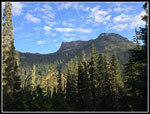 Lichtenberg Mountains |
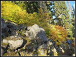 Varying Colors |
 Great Colors! |
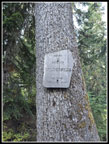 Wilderness Sign |
 Running Water |
 Meadow |
 Eaten Mushroom |
 Just Coming Up |
 Protected Amanita |
 Gary Enjoys View |
 First Pika |
 Posing Pika |
 Great Fern Color |
 First Lake View |
 Jim & Gary At Valhalla |
 Lake Valhalla |
 Heading For Pass |
 Mts. Daniel & Hinman |
 Color On McCausland |
 Summit Ridge Above |
 Steep Spot Ahead |
 Better Colors |
 Lichtenberg & Valhalla |
 Fog At Stevens? |
 Columbia, Kyes, & Cadet |
 Pugh, White Chuck, Glacier |
 Glacier Peak |
 Sloan Peak |
 Colors On Top |
 Jove Peak |
 Great Red Color |
 Peak & Lake |
 More Red Color |
 Gary, View, & Colors |
 Starting Down |
 Trail Below Pass |
 Back At Lake Valhalla |
 Back At Pika Spot |
 Looking Back |
 A Few Last Berries |
 Big Meadow |
 View Before RR Grade |
 Gary & Great Colors |
 On The Grade Again |
Trips - 2025
Home