01-19-25
Gary
and John joined me for a Sunday hike to Wallace Falls and Lake. It is a
longer than average hike that has several additional options to make it
even longer. It also has below average elevation gain. The combination
can make for a big mileage day. I have done up to 17 miles. We were not
looking for that much but 12-15 miles would be great. It was going to
be a cold and sunny day. We do not get a lot of all blue sky days in
January. Traffic can be awful on any Sunday coming home on Highway 2.
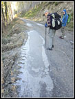
We decided on an early start. Wallace Falls State Park opens at 8:00
am. We planned to be just a little earlier. We met in Bothell at 7:10
am and headed east. We arrived at the park at 7:49 am to find cars near
the rental cabins and just a couple more near the trailhead. It was a
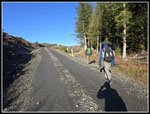
chilly 26F as we started hiking at 7:54 am. Per the forecast the sky
was blue and it stayed that way all day. It was hard to warm up on the
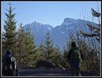
flat gravel road at the start. We stopped for a view under the
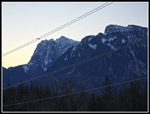
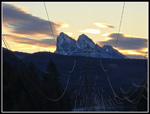
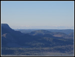
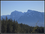
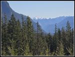
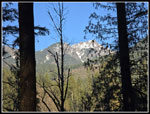
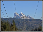
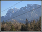
powerlines up the valley to Baring Mountain Mt. Index, and Mt. Persis.
Even with the wires in the way, this is a great viewpoint on a clear
day.
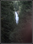
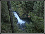
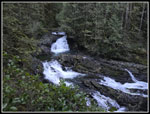
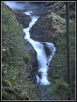
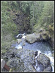
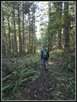
From there the trail heads into the forest. We quickly turned right on the Woody Trail. This route follows the Wallace River on the way up to all the falls. The other route is the old railroad grade. That would be our route coming back. Almost our entire route is a big loop. The Woody Trail drops down to the river. It was along here that we spotted several patches of hair ice. It only forms on deciduous wood with the temperature below freezing. I do not see it very often. This was a nice surprise. The route begins to climb and we started to warm up. A few ups and downs brought us to the bridge over the North Form of the Wallace River. We would cross it again at the outlet to Wallace Lake. So far we had seen only one person coming out. Up at the picnic shelter are great views of some smaller waterfalls. The lighting was pretty good for photos.
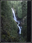
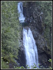
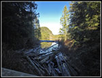
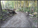
Next, we headed up to the bigger falls. We stopped for more views and photos at the viewpoint for the middle falls. There was a good flow though less than many rainy periods this time of year. We saw one group here and passed a larger group before the upper falls. We had time alone at the upper falls before they arrived. Now we were down with the waterfalls and headed on towards Wallace Lake. The path up to the logging road above was sketchy at the bottom. It is not anymore. Now it is very easy to follow with markers on trees all the way up. At the road we turned right and headed towards the bridge over the river just above the upper falls. On the other side we looked for any signs of flagging for the trail that will one day reach here from the Reiter Trailhead. There were no signs as of now. We turned around, recrossed the bridge and headed on towards Wallace Lake. There were a lot of small branches and a few larger ones on the road/trail. They were from the late November big storm that shut down the park fore weeks while fallen trees were removed.
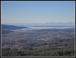
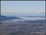
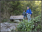
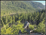
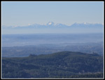
Right where we left the park the somewhat recent clearcut began. A short way farther we went over to a landing with big views up and down the Skykomish Valley. We arrived at 9:52 am. So far we had gained most of the day's elevation and taken a lot of photos. Our pace was not very fast., having taken 1:52 to hike 3.1 miles. That is why early starts are so helpful when days are short. A sign at the trailhead stated that the park was closing at 5:20 pm. That is just a little after full darkness. We had some very nice views from the logging landing. The Olympic Mountains were sunlit to the west. Fog filled the lowlands farther west. We were looking down on the top of it. The towers of Bellevue and Seattle were visible. Across the valley is Mt. Sultan. I have come close to reaching the top. It is a very long day at must over 20 miles. We did have a little sunshine here. It really felt warmer than the shady trail. I started with two layers on top but had to stop for a windshirt for more warmth. It still felt below freezing.
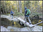
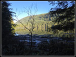
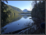
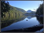
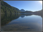
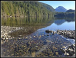
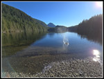
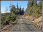
The road walk is pretty flat. There is a well signed turn angling off right and a "T" junction where we turned right again. After that we left the newer logging road for the old one heading to Wallace Lake. A couple small creeks turned the road into a lake in past years but a few years back a raised track proved a dry route. There is even a short bridge over the water. It is now easy to reach the lake with dry boots. The last part enters the state park again near the lake. We stopped at the outlet bridge for a look down the lake. It was not clear if Pebble Beach at the inlet would be underwater. It often is as the winter rains raise the lake level. We continued around the lake. There is a viewpoint with a bench before reaching the inlet creek. We dropped down to it for some looks down the lake. I still could not see if Pebble Beach was underwater. We quickly reached the inlet creek. The path to the "beach" is in the creek bed. Much of the year it is dry. In winter, it can be quite fast flowing. This time it was completely dry. Even the big puddles along it were mostly dry.
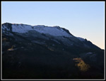
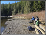
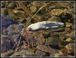
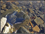
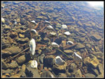
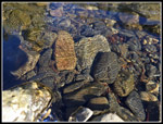
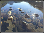
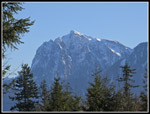
We had no trouble reaching the beach site. With the lack of recent water, there was plenty of beach. We were now back in complete sunshine with little wind. It as cold but so much better with the sunshine. We arrived at 11:07 am. We had traveled 6.1 miles. The previous 3 miles took only 1:09. It was time for lunch. We had seen nobody since just below the upper falls. This is a busy park but we had a lot of solitude. It continued for most of our trip. John made an interesting discovery. There was a little inlet where the creek would run into the lake. It had a very thin layer of ice on it. Looking down the ice was not noticeable. It just looked like water. Bending down the ice was slightly visible. John decided to place a rock on the water/ice. As thin as the ice was it held the rock. It sure looked like we found some floating rocks. The rock made a shadow below it so it was clearly not touching bottom. We had great fun laying more rocks on "the water". Over time the relative warmth of the rocks and their weight allowed them to begin to sink. One rock dropped completely under the water level and still floated. Rocks underwater showed really neat patterns from the sun shining through the ice layer. They looked like some ancient rock carvings. These were really neat. We had lots of things to keep us busy as well as admiring the great views of the lake and snowy Mt. Index behind it.
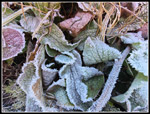
By the time we packed up to go it was 12:07 pm. We spent a full hour at the lake. In recent years I have added as short detour to get some more views and some elevation gain. We detoured out into a clearcut from 7-10 years ago. We went up to the ridge top above the lake and had views down to part of the lake. Views out to the Skykomish Valley were excellent. We also had another spot to soak up the sunshine. In addition to the Olympics, we would see Mt. Index and Mt. Persis. The fog to the west seen in the morning was now almost entirely gone. The top of Seattle buildings were again in sight. We had a little more food and water and headed back. In the clearcut shaded areas were white with frost. A few feet away puddles that were frozen in the morning were now thawed. We soon reached the lake outlet and headed for the main logging road. This section always bothers me as the gravel is large and sometimes sharp. It is not much fun to walk on.
We reached the road at 1:26 pm. We had traveled 8.4 miles. We had a decision to make. A short way along the road we reached the sign stating that it is 5.9 miles back to the trailhead via the road and trails. Just after that is the Greg Ball Trail. It is only 3.5 miles back via that trail. Did we want the shorter though dark and shady trail or the longer road with much sunshine. The vote was for the sunshine. The road is much easier on feet than the trail from the lake to the road. It is long. Our pace picked up markedly. We hiked the 3.5 miles of road at 2.9 mph. That is not bad for some tired legs. The sunshine was nice. We had some final views of Index and Persis as well as a very small waterfall. We left the road for a trail down to the old railroad grade. We reached the grade with 1.5 miles to go. After not having seen anyone since the Greg Ball Trail we finally saw a few people on the last part. We closed the loop at the start of the Woody Trail and then took another stop under the powerlines with the great Baring, Index, and Persis views. The afternoon views were much less full of glare than I expected. We reached the parking lot at 3:31 pm. That was almost two hours before the park would close. The drive home was slower as expected but not terrible.
This trip turned out great. We hiked just over 14 miles with 2100' of elevation gain. We saw very few people compared to what I usually see at Wallace Falls State Park. It is January but I have seen many more people this time if year on overcast days. This was a great day to be outdoors and in the sunshine. Having an hour alone at Pebble Beach is very unusual. The floating rocks and strangely patterned rocks were an unexpected treat. The clear views were great. All in all, it was a fantastic winter day. It was cold but the sunshine made up for it.
Click on thumbnails to get
larger pictures.
Trips - 2025
Home
From there the trail heads into the forest. We quickly turned right on the Woody Trail. This route follows the Wallace River on the way up to all the falls. The other route is the old railroad grade. That would be our route coming back. Almost our entire route is a big loop. The Woody Trail drops down to the river. It was along here that we spotted several patches of hair ice. It only forms on deciduous wood with the temperature below freezing. I do not see it very often. This was a nice surprise. The route begins to climb and we started to warm up. A few ups and downs brought us to the bridge over the North Form of the Wallace River. We would cross it again at the outlet to Wallace Lake. So far we had seen only one person coming out. Up at the picnic shelter are great views of some smaller waterfalls. The lighting was pretty good for photos.
Next, we headed up to the bigger falls. We stopped for more views and photos at the viewpoint for the middle falls. There was a good flow though less than many rainy periods this time of year. We saw one group here and passed a larger group before the upper falls. We had time alone at the upper falls before they arrived. Now we were down with the waterfalls and headed on towards Wallace Lake. The path up to the logging road above was sketchy at the bottom. It is not anymore. Now it is very easy to follow with markers on trees all the way up. At the road we turned right and headed towards the bridge over the river just above the upper falls. On the other side we looked for any signs of flagging for the trail that will one day reach here from the Reiter Trailhead. There were no signs as of now. We turned around, recrossed the bridge and headed on towards Wallace Lake. There were a lot of small branches and a few larger ones on the road/trail. They were from the late November big storm that shut down the park fore weeks while fallen trees were removed.
Right where we left the park the somewhat recent clearcut began. A short way farther we went over to a landing with big views up and down the Skykomish Valley. We arrived at 9:52 am. So far we had gained most of the day's elevation and taken a lot of photos. Our pace was not very fast., having taken 1:52 to hike 3.1 miles. That is why early starts are so helpful when days are short. A sign at the trailhead stated that the park was closing at 5:20 pm. That is just a little after full darkness. We had some very nice views from the logging landing. The Olympic Mountains were sunlit to the west. Fog filled the lowlands farther west. We were looking down on the top of it. The towers of Bellevue and Seattle were visible. Across the valley is Mt. Sultan. I have come close to reaching the top. It is a very long day at must over 20 miles. We did have a little sunshine here. It really felt warmer than the shady trail. I started with two layers on top but had to stop for a windshirt for more warmth. It still felt below freezing.
The road walk is pretty flat. There is a well signed turn angling off right and a "T" junction where we turned right again. After that we left the newer logging road for the old one heading to Wallace Lake. A couple small creeks turned the road into a lake in past years but a few years back a raised track proved a dry route. There is even a short bridge over the water. It is now easy to reach the lake with dry boots. The last part enters the state park again near the lake. We stopped at the outlet bridge for a look down the lake. It was not clear if Pebble Beach at the inlet would be underwater. It often is as the winter rains raise the lake level. We continued around the lake. There is a viewpoint with a bench before reaching the inlet creek. We dropped down to it for some looks down the lake. I still could not see if Pebble Beach was underwater. We quickly reached the inlet creek. The path to the "beach" is in the creek bed. Much of the year it is dry. In winter, it can be quite fast flowing. This time it was completely dry. Even the big puddles along it were mostly dry.
We had no trouble reaching the beach site. With the lack of recent water, there was plenty of beach. We were now back in complete sunshine with little wind. It as cold but so much better with the sunshine. We arrived at 11:07 am. We had traveled 6.1 miles. The previous 3 miles took only 1:09. It was time for lunch. We had seen nobody since just below the upper falls. This is a busy park but we had a lot of solitude. It continued for most of our trip. John made an interesting discovery. There was a little inlet where the creek would run into the lake. It had a very thin layer of ice on it. Looking down the ice was not noticeable. It just looked like water. Bending down the ice was slightly visible. John decided to place a rock on the water/ice. As thin as the ice was it held the rock. It sure looked like we found some floating rocks. The rock made a shadow below it so it was clearly not touching bottom. We had great fun laying more rocks on "the water". Over time the relative warmth of the rocks and their weight allowed them to begin to sink. One rock dropped completely under the water level and still floated. Rocks underwater showed really neat patterns from the sun shining through the ice layer. They looked like some ancient rock carvings. These were really neat. We had lots of things to keep us busy as well as admiring the great views of the lake and snowy Mt. Index behind it.
By the time we packed up to go it was 12:07 pm. We spent a full hour at the lake. In recent years I have added as short detour to get some more views and some elevation gain. We detoured out into a clearcut from 7-10 years ago. We went up to the ridge top above the lake and had views down to part of the lake. Views out to the Skykomish Valley were excellent. We also had another spot to soak up the sunshine. In addition to the Olympics, we would see Mt. Index and Mt. Persis. The fog to the west seen in the morning was now almost entirely gone. The top of Seattle buildings were again in sight. We had a little more food and water and headed back. In the clearcut shaded areas were white with frost. A few feet away puddles that were frozen in the morning were now thawed. We soon reached the lake outlet and headed for the main logging road. This section always bothers me as the gravel is large and sometimes sharp. It is not much fun to walk on.
We reached the road at 1:26 pm. We had traveled 8.4 miles. We had a decision to make. A short way along the road we reached the sign stating that it is 5.9 miles back to the trailhead via the road and trails. Just after that is the Greg Ball Trail. It is only 3.5 miles back via that trail. Did we want the shorter though dark and shady trail or the longer road with much sunshine. The vote was for the sunshine. The road is much easier on feet than the trail from the lake to the road. It is long. Our pace picked up markedly. We hiked the 3.5 miles of road at 2.9 mph. That is not bad for some tired legs. The sunshine was nice. We had some final views of Index and Persis as well as a very small waterfall. We left the road for a trail down to the old railroad grade. We reached the grade with 1.5 miles to go. After not having seen anyone since the Greg Ball Trail we finally saw a few people on the last part. We closed the loop at the start of the Woody Trail and then took another stop under the powerlines with the great Baring, Index, and Persis views. The afternoon views were much less full of glare than I expected. We reached the parking lot at 3:31 pm. That was almost two hours before the park would close. The drive home was slower as expected but not terrible.
This trip turned out great. We hiked just over 14 miles with 2100' of elevation gain. We saw very few people compared to what I usually see at Wallace Falls State Park. It is January but I have seen many more people this time if year on overcast days. This was a great day to be outdoors and in the sunshine. Having an hour alone at Pebble Beach is very unusual. The floating rocks and strangely patterned rocks were an unexpected treat. The clear views were great. All in all, it was a fantastic winter day. It was cold but the sunshine made up for it.
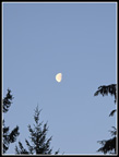 The Moon In The Sky... |
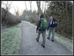 Bundled Up On The Trail |
 Mts. Index & Persis |
 Morning Baring Mountain |
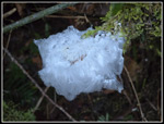 Hair Ice |
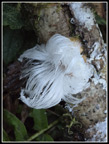 More Hair Ice |
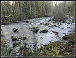 Wallace River |
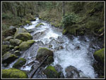 NF Wallace River |
 First Falls |
 Lower Falls |
 Cascades |
 Middle Falls |
 Lower Middle Falls |
 Upper Falls |
 Above Upper Falls |
 Looking West |
 Fog & Olympic Mts. |
 Bellevue & Seattle |
 Haystack Ridge |
 Big Icy Puddle |
 Leaving Road |
 Long Shadows |
 Over The Bridge |
 At Wallace Lake |
 Smooth Water |
 Looking Down Lake |
 At Lake Level |
 John & Gary |
 Wallace Lake Inlet |
 Lake From Beach |
 Lunch Time |
 Floating Rock |
 Frozen Rocks |
 More Floating Rocks |
 Neat Apparent Marks |
 Lake & Rocks |
 Sinking Rocks |
 Lake & Beach |
 Frozen Leaves |
 Lake From Ridge |
 Peaks From Ridge |
 Hazy Mountains |
 Mt. Hinman |
 Wildflowers? |
 Wallace Lake Dam |
 Peaks From Road |
 Mt. Index |
 On The Road Again |
 Mossy Trees |
 Forest Trail |
 Fallen Trees |
 Another Peak |
 Afternoon Baring Mt. |
 Last Mt. Shot |
Trips - 2025
Home