12-13-25
This
week was one of record
flooding. Seattle did not get a lot of rain but everywhere else did.
The Suiattle Road washed out again. The Index-Galena Road washed out
again. Highway 2 is closed. I needed to find somewhere to go hiking.
The rivers had peaked and were starting to drop. I thought Wallace
Falls would meet a lot of points. The falls would be full though not as
high as a few days earlier. Highway 2 was closed at Skykomish. With no
cross pass traffic the driving should be easier than usual. With an
early start I should be well up the trail before the crowds arrived.
Also I was trying to get my fourth consecutive 900 mile year. I still
needed 49 more miles. A big loop to the falls and Wallace Lake would
get me 10-14 miles depending on the route. More rain was in the
forecast for the next week. Saturday looked to be sunny and unusually
warm. A sunny day on the trail sounded good. On the negative side, my
knee has been sore for three or four weeks. A long trip might end on a
painful note. Wallace Falls and Lake it was.
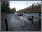
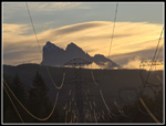
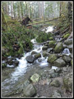
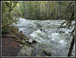
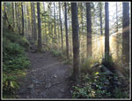
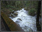
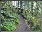
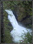
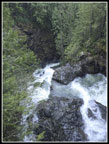
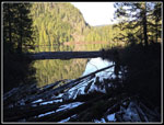
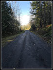
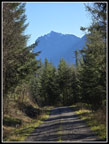
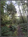
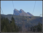
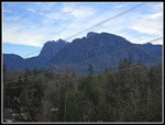
I was not out the door as early as hoped and I arrived at the trailhead at 8:12 am. The lot was 80%+ empty. With the fast running falls and so many places closed, I thought the lot would fill up fast. There were no people in the lot at all. I was on my way at 8:17 am. With no snow, I usually take light hiking shoes and no poles. With unknown water depth and a sore knee I took both. The morning sun was low and right in my eyes at the start. I stopped at the Baring Mountain and Mt. Index viewpoint. The sunshine and a few low clouds in the distance made for a very pretty view. The road/trail turned into the forest immediately. I usually take the old railroad grade trail as it is smooth and longer. This day I wanted to see the Wallace River. The Woody Trail drops quickly down to river level. There were no signs that it overflowed onto the trail. I seldom take the short route over to Small Falls as it is a trickle much of the year. This day it had a good flow. There are several places along the trail where you can go over to the river for a look. It was flowing fast and wide but not abnormally so. It must have dropped quickly when the rain stopped.
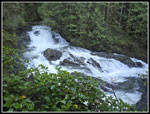
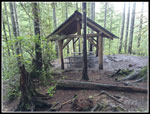
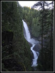
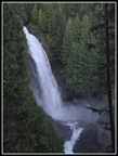
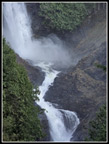
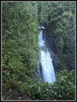
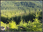
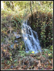
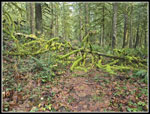
The trail has ups and downs and lots of steps. I set a decent though not fast pace. One hiker zipped on past me. The trail climbs to a high point and descends to the NF Wallace River. I would later cross it again right at the outlet to Wallace Lake. The NF was flowing high enough to put on a good show from the bridge across it. A steep climb brought me up to the picnic shelter with a good view of some of the lower Wallace falls and cascades. On my last visit in January, it was below freezing when we arrived and the falls did not have a lot of water. This day was much better. I started hiking with a temperature in the mid 40s. It felt much warmer already. After some time for photos, I was back on my way. I stopped again at the Middle Falls viewpoint. It as not the biggest I have seen the falls but it was impressive. As I was leaving two other hikers caught up with me. On the way to the upper falls there was a small tree down across the trail. The other hikers caught up as I was cutting it up and helped to get it off the trail. That was the only tree across the trail the entire day. The big storm dropped a lot of rain and had some big winds but did almost no damage here.
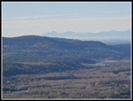
I reached the upper falls to find the two hikers about to head down. I took a few photos when a long hiker arrived. This was Terry's first time at Wallace Falls. He was planning to also hike to the Lake and make it a loop trip. We ended up hiking to Wallace Lake together. I gave him a tour of a few viewpoint off the main trail. We climbed up to the road/trail above the falls and turned right. We crossed the bridge over the river and headed back. Just after the trail leaves the park and enters a clearcut from 7 or 8 years ago, we went over to the edge of the slope where a logging landing was built. It provides great views up and down the valley. With clear skies the views were very good. We could see the Skykomish River below and it was back within its banks. What was most noticeable was the lack of snow on the ridges. All that rain washed away the lower snow accumulations. We hiked the road to the "T" junction. To the right is Wallace Lake. To the left is the main logging road I would take down from the lake. Turning left gets to the lake on a longer route. To the right is a spot that can turn into a big deep and wide overflowing creek. I was prepared to possibly turn around and have to take the longer route.
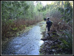
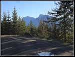
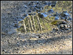
We reached the sot where the now old grassy road crosses the small summer creek. The road was underwater at least 100 feet from the creek. The parks people have built up a walkway on rocks to the right side. Then there is a short narrow bridge. They worked perfectly this day. I did not come close to overflowing my high top boots. and kept dry feet. Terry had low tops and he too rock hopped the wet spots. Once across it is only a few minutes to the bridge over the Wallace Lake outlet. Looking down the lake I could not tell for sure if Pebble Beach at the inlet was underwater. It is a good bet after a major rain storm that it will be. On our way to the other end of the lake we took my detour to a viewpoint in a clearcut. From the top, we could look down on part of Wallace Lake. We still had nothing but blue sky overhead. This was the highest point of the trip and it was quite warm in the sunshine. It felt like the mid 60s. I was even sweating a bit on the last steep climb up.
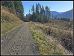
We went over to a great view of the valley. Normally, the towers of Seattle appear over the ridge to the southwest. This day it was still very cloudy by Puget Sound. No signs of Seattle were visible. The Olympic Mountains were very much out in the open. We retraced our steps back to the lake and headed for the inlet. One last detour was down to a bench on the shore. We had a good look back down the lake. Pebble Beach did look to be underwater. The last bit to the inlet had the old road underwater. We trod the very edge where it was drier. The inlet creek is dry most of the year and the route to Pebble Beach. Last January it as totally dry. Now it was a fast flowing creek. Tires filled with rocks provide wide steeping spots but they were completely underwater. Terry was interested in going to Jay Lake but I was not. I have been there many times. He jumped across with slightly wet shoes. We said goodbye and he headed on. With the bright sunshine, I had decided to take the longer DNR road back instead of the Greg Ball Trail. It is 1.7 miles longer and has a rocky surface vs. the dirt trail but would be partly in quite warm sunshine not dark forest. That sounded good this day. The added mileage was a good reason to pass on Jay Lake. This would bring me up the longer 14 miles route. It might get a bit painful on my knee but it was a warm December sunny day and it seemed worth it.
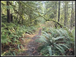
So far I had hiked about 7.1 miles which was just about the halfway point. Halfway in distance but about 90% of the elevation gain. I stopped again at the bench by the lakeshore for a lunch break. It was now 11:33 am. I then noticed a guy kayaking on the lake not far from me. Whatever he used must have been carried up from the trailhead. It looked to be more than just a blow up boat. I was back on my way within 10 minutes. I hiked back to the outlet then out to the DNR road. I saw two hikers on this stretch. It is only 4.1 miles to the lake via the Woody and Greg Ball Trails. At the road I went a short way left to the vehicle bridge over the NF Wallace River. The flow was strong and noisy. I headed down the road to the top of the Greg Ball Trail. Just before that, I passed a sign noting it was 5.9 miles back to the trailhead via the DNR road and Railroad Grade trail. It was only a few minutes later that I passed a couple hiking up the road. I seldom ever see hikers on the road.
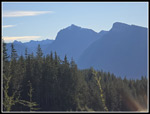
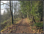
My old high top boots did not seem to have much padding on the bottom. My feet were already getting sore. I have hiked the road many times without sore feet. This day was different. Downhill is where my knee hurts most. The road is pretty smooth and lacks big steps seen on the trails but it is long. The road was not pleasant for my feet. The offset was the warm sunshine. I hiked the entire day with just a light long sleeve shirt and was never cold. Part way down near the quarry, I had great views of Mt. Index and Mt. Persis. They were below blue sky still. I was glad to leave the road for the dirt connector trail that goes over to the Railroad Grade. At the junction two runners were coming up the trail. The trail can be a little muddy in the dry season so I was prepared for some boggy spots. That really did not happen. The wet spots were short and not deep. With all the rain and flooding I expected more water on the trail. I popped out onto the Railroad Grade right at the 1.5 mile marker. It was 1:46 pm. At the end of the DNR road section some clouds were coming in. On the Railroad Grade I could see up and it was getting pretty white.
I passed the start of the Woody Trail and then popped out of the forest and onto the last road section. I went over to the Baring and Index Mt. viewpoint. The view was radically different than in the morning. The bright sun in my face in the morning was now overhead. The lighting was much different. I took a few photos and zipped down the road to the trailhead. I arrived at 2:18 pm. The lot was mostly full but with quite a few open spots. The sky was white but it was in the high 50s and quite warm. For the day I hiked 14.3 miles with 2100' of elevation gain. I saw about a dozen people over the 6:01 I was out hiking. The sunshine was very nice. We don't see much in December. The crowds never arrived. Hiking with Terry added to a wonder day on the trail.
Click on thumbnails to get
larger pictures.
Trips - 2025
Home
I was not out the door as early as hoped and I arrived at the trailhead at 8:12 am. The lot was 80%+ empty. With the fast running falls and so many places closed, I thought the lot would fill up fast. There were no people in the lot at all. I was on my way at 8:17 am. With no snow, I usually take light hiking shoes and no poles. With unknown water depth and a sore knee I took both. The morning sun was low and right in my eyes at the start. I stopped at the Baring Mountain and Mt. Index viewpoint. The sunshine and a few low clouds in the distance made for a very pretty view. The road/trail turned into the forest immediately. I usually take the old railroad grade trail as it is smooth and longer. This day I wanted to see the Wallace River. The Woody Trail drops quickly down to river level. There were no signs that it overflowed onto the trail. I seldom take the short route over to Small Falls as it is a trickle much of the year. This day it had a good flow. There are several places along the trail where you can go over to the river for a look. It was flowing fast and wide but not abnormally so. It must have dropped quickly when the rain stopped.
The trail has ups and downs and lots of steps. I set a decent though not fast pace. One hiker zipped on past me. The trail climbs to a high point and descends to the NF Wallace River. I would later cross it again right at the outlet to Wallace Lake. The NF was flowing high enough to put on a good show from the bridge across it. A steep climb brought me up to the picnic shelter with a good view of some of the lower Wallace falls and cascades. On my last visit in January, it was below freezing when we arrived and the falls did not have a lot of water. This day was much better. I started hiking with a temperature in the mid 40s. It felt much warmer already. After some time for photos, I was back on my way. I stopped again at the Middle Falls viewpoint. It as not the biggest I have seen the falls but it was impressive. As I was leaving two other hikers caught up with me. On the way to the upper falls there was a small tree down across the trail. The other hikers caught up as I was cutting it up and helped to get it off the trail. That was the only tree across the trail the entire day. The big storm dropped a lot of rain and had some big winds but did almost no damage here.
I reached the upper falls to find the two hikers about to head down. I took a few photos when a long hiker arrived. This was Terry's first time at Wallace Falls. He was planning to also hike to the Lake and make it a loop trip. We ended up hiking to Wallace Lake together. I gave him a tour of a few viewpoint off the main trail. We climbed up to the road/trail above the falls and turned right. We crossed the bridge over the river and headed back. Just after the trail leaves the park and enters a clearcut from 7 or 8 years ago, we went over to the edge of the slope where a logging landing was built. It provides great views up and down the valley. With clear skies the views were very good. We could see the Skykomish River below and it was back within its banks. What was most noticeable was the lack of snow on the ridges. All that rain washed away the lower snow accumulations. We hiked the road to the "T" junction. To the right is Wallace Lake. To the left is the main logging road I would take down from the lake. Turning left gets to the lake on a longer route. To the right is a spot that can turn into a big deep and wide overflowing creek. I was prepared to possibly turn around and have to take the longer route.
We reached the sot where the now old grassy road crosses the small summer creek. The road was underwater at least 100 feet from the creek. The parks people have built up a walkway on rocks to the right side. Then there is a short narrow bridge. They worked perfectly this day. I did not come close to overflowing my high top boots. and kept dry feet. Terry had low tops and he too rock hopped the wet spots. Once across it is only a few minutes to the bridge over the Wallace Lake outlet. Looking down the lake I could not tell for sure if Pebble Beach at the inlet was underwater. It is a good bet after a major rain storm that it will be. On our way to the other end of the lake we took my detour to a viewpoint in a clearcut. From the top, we could look down on part of Wallace Lake. We still had nothing but blue sky overhead. This was the highest point of the trip and it was quite warm in the sunshine. It felt like the mid 60s. I was even sweating a bit on the last steep climb up.
We went over to a great view of the valley. Normally, the towers of Seattle appear over the ridge to the southwest. This day it was still very cloudy by Puget Sound. No signs of Seattle were visible. The Olympic Mountains were very much out in the open. We retraced our steps back to the lake and headed for the inlet. One last detour was down to a bench on the shore. We had a good look back down the lake. Pebble Beach did look to be underwater. The last bit to the inlet had the old road underwater. We trod the very edge where it was drier. The inlet creek is dry most of the year and the route to Pebble Beach. Last January it as totally dry. Now it was a fast flowing creek. Tires filled with rocks provide wide steeping spots but they were completely underwater. Terry was interested in going to Jay Lake but I was not. I have been there many times. He jumped across with slightly wet shoes. We said goodbye and he headed on. With the bright sunshine, I had decided to take the longer DNR road back instead of the Greg Ball Trail. It is 1.7 miles longer and has a rocky surface vs. the dirt trail but would be partly in quite warm sunshine not dark forest. That sounded good this day. The added mileage was a good reason to pass on Jay Lake. This would bring me up the longer 14 miles route. It might get a bit painful on my knee but it was a warm December sunny day and it seemed worth it.
So far I had hiked about 7.1 miles which was just about the halfway point. Halfway in distance but about 90% of the elevation gain. I stopped again at the bench by the lakeshore for a lunch break. It was now 11:33 am. I then noticed a guy kayaking on the lake not far from me. Whatever he used must have been carried up from the trailhead. It looked to be more than just a blow up boat. I was back on my way within 10 minutes. I hiked back to the outlet then out to the DNR road. I saw two hikers on this stretch. It is only 4.1 miles to the lake via the Woody and Greg Ball Trails. At the road I went a short way left to the vehicle bridge over the NF Wallace River. The flow was strong and noisy. I headed down the road to the top of the Greg Ball Trail. Just before that, I passed a sign noting it was 5.9 miles back to the trailhead via the DNR road and Railroad Grade trail. It was only a few minutes later that I passed a couple hiking up the road. I seldom ever see hikers on the road.
My old high top boots did not seem to have much padding on the bottom. My feet were already getting sore. I have hiked the road many times without sore feet. This day was different. Downhill is where my knee hurts most. The road is pretty smooth and lacks big steps seen on the trails but it is long. The road was not pleasant for my feet. The offset was the warm sunshine. I hiked the entire day with just a light long sleeve shirt and was never cold. Part way down near the quarry, I had great views of Mt. Index and Mt. Persis. They were below blue sky still. I was glad to leave the road for the dirt connector trail that goes over to the Railroad Grade. At the junction two runners were coming up the trail. The trail can be a little muddy in the dry season so I was prepared for some boggy spots. That really did not happen. The wet spots were short and not deep. With all the rain and flooding I expected more water on the trail. I popped out onto the Railroad Grade right at the 1.5 mile marker. It was 1:46 pm. At the end of the DNR road section some clouds were coming in. On the Railroad Grade I could see up and it was getting pretty white.
I passed the start of the Woody Trail and then popped out of the forest and onto the last road section. I went over to the Baring and Index Mt. viewpoint. The view was radically different than in the morning. The bright sun in my face in the morning was now overhead. The lighting was much different. I took a few photos and zipped down the road to the trailhead. I arrived at 2:18 pm. The lot was mostly full but with quite a few open spots. The sky was white but it was in the high 50s and quite warm. For the day I hiked 14.3 miles with 2100' of elevation gain. I saw about a dozen people over the 6:01 I was out hiking. The sunshine was very nice. We don't see much in December. The crowds never arrived. Hiking with Terry added to a wonder day on the trail.
 Few Cars In Lot |
 Morning Light On Baring |
 Small Falls |
 Wallace River |
 Light In The Forest |
 NF Wallace River |
 Log Over Trail |
 Whitewater Cascades |
 Lower Falls |
 Picnic Shelter |
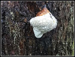 Guttation? |
 Middle Wallace Falls |
 Closer Look |
 Mist Blows Away |
 More Light In Forest |
 Very Green Slope |
 Upper Wallace Falls |
 Top Of Upper Falls |
 Valley Viewpoint Valley Viewpoint |
 Terry & High Water |
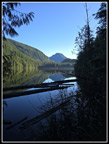
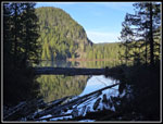
 Lake From Outlet |
 Wallace Lake Below |
 Mts. Index & Persis |
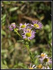
 December Blooming Daisy |
 Lunch Spot At Lake |
 Kayaker |
 Back At Outlet |
 More Wildflowers |
 Shady Road |
 A Small Waterfall |
 Index & Persis Again |
 Puddle Art |
 Index Front & Center |
 Out In Sunshine |
 Leaving Road |
 Mossy Arch |
 Mossy Tree |
 Tree Over Trail |
 Best Mossy Spot |
 Sunshine On RR Grade |
 Afternoon Baring |
 Index & Baring |
Trips - 2025
Home