11-08-25
I
have a busy month coming and I'm not sure how many hikes I will be able
to get in. I needed a long trip to get the month started. Also, it
rained much of the past week and that should happen next week too. The
weekend looked to be partly clear and near 60 degrees. I planned a
second trip this year up West Rattlesnake Mountain from Highway 18.
Gary was available on Saturday. I suggested this trip and he signed on.
At 17 miles with 2600' of gain this is a long trip. West Rattlesnake
can be reached via the Rattlesnake Mountain Trail in about half the
distance. My planned route is much longer and much less crowded. The
days are getting shorter and with Standard Time now back, it gets dark
at about 5:00 pm. We needed an early start. Gary picked me up at 6:25
am and we headed east. Highway 18 has a new double diamond interchange
and two lanes the first couple miles. There is a turn lane right by the
parking spot for this trip. It crosses two lanes now but was easy
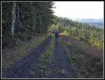
enough early in the morning. We arrived at about 7:00 am. We started
out at 7:06 am. It as in the upper 30s and we moved fast to warm up. We
crossed the swamp and ascended the first hill. We passed the power
sub-station with a view over to East Tiger Mountain. At the end of the
station we reached the 1 mile marker. There are markers at almost every
half mile up to the 6.5 mile mark where another road is met and the
mile markers are from that road's beginning. There are a few big
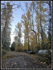
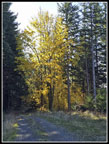
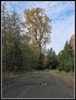
deciduous trees in the next half mile and they still had most of their
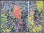
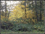
golden leaves. Farther along, many trees had shed lots of their leaves.
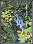
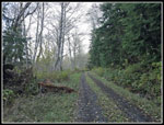
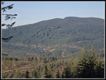
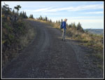
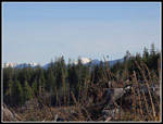
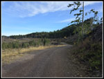
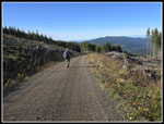
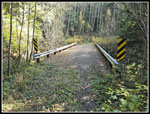
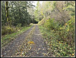
After two miles we had another uphill to the bridge over Canyon Creek. We passed bike trails on each side of the bridge. These are bike only. I hiked the one after the bridge before it was opened. Then comes the straight up road climb. This is the largest ascent in the first 4.5 miles. That warmed me up. At the top the road swings to the right. Another unmarked road goes to the left. That is my short detour to bring the total mileage up to 17. We were making very good time. We stayed at or above 3 mph all the way to the summit. We passed a side road at the 4 mile marker. We saw a truck for the second time heading up the side road and then ahead on our road. That truck is all we saw from the starting gate to the top. I saw a couple mushrooms along here and they were the only ones seen all day. We reached the 4.5 mile spot at 8:29 am. This is where the summit road turns left and begins a steady ascent. We took a short break. We covered the 4.5 miles in 1:23. A pace of 18.44 minutes/mile is very fast for us old guys. The road starts uphill steeply then the grade eases. We soon reached recent clearcuts. What was once a deep forest walk is now a view hike.
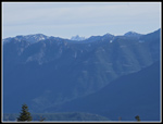
As we climbed we could hear the wind. The forecast was for 6-9 mph but it sounded much faster. The tree tops were now bending back and forth. This was not expected. Below, the sun was too low to shine on us. Higher up, we had a few spots in the sunshine. It really did feel warmer. Views across to Tiger Mountain opened up. Then we saw some of the Olympic Mountains. The road took one last drop to the 6 mile marker. At 6.5 miles we met the current main road. We turned right and continued climbing. Soon we passed the first of three bike trail crossings.There are often bikers resting on the road but there were none today. Now the sun was out and warm but we saw more forest ahead. Our pace slowed as the warmth was much appreciated. We had some more wind as we neared the top. The peak was blocking much of the easterly wind but it was swirling around the mountain and reaching us. It was not as strong as the sound seemed earlier. We went into forest and reached the switchback. This is where the road comes very close to the Rattlesnake Mountain Trail.
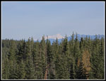
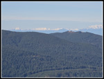
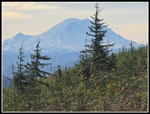
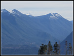
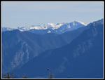
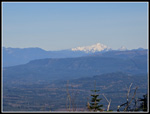
The next traverse towards the south had better views or the Olympics and downtown Bellevue. We even had a look at Mt. Baker. Some clouds were coming in but it was still mostly blue sky. The next switchback was the last one. Then it was just a short climb to the top. We reached the summit at 9:55 am. I am not used to being 8 miles up a trail before 10:00 am. We had hiked 8 miles in 2:49 including breaks. That was 21 minutes/mile or right on 3 mph moving time. We were now high enough to see west to all the Olympic Mountains over the top of Tiger Mountain's peaks. North were Mt. Baker and Three Fingers. To the east we could see Mt. Si, Mt. Teneriffe, and the peaks of the MF and SF Snoqualmie River. The latter is the route of I-90 over Snoqualmie Pass. Unfortunately, it was too cold and windy on top. I usually drop down the east side a bit for a little more mileage and elevation gain. Today it was also to try to get out of the wind. Down at the lower towers we found a sunny spot with a wind block from the tower buildings. It was too early for lunch but I guess it was brunch. We had seen most everything except Mt. Rainier.
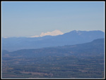
After brunch we headed back to the summit. As we left, some hikers were coming up from Grand Prospect. At the top, it was much less windy. Just a light wind shirt sufficed. I went over to where I had a view of Mt. Rainier for some last summit photos. As we headed back to the road the hikers arrived. One of them was Debbie and she turned out to be Debbie Anschell of Debbie's View on Squak Mountain and Anschell's Allee on West Tiger Mountain. I have known of her for a long time but we had not met. Gary took a photo of Debbie and I. After that it was time to get out of the cold wind. We left the summit at 10:46 am. We just had another 8 miles to go. I was still debating taking my detour to get the mileage up to 17. We made pretty good time going down. The first 1.5 miles we passed three or four groups of mountain bikers. I think there were about ten of them all together. High up we had a look at the top of Glacier Peak and all of Mt. Index. The other views began to disappear.
At 1.5 miles down we left the newer road for the old one we came up. This road is about 1.5 miles longer than the other but much more lonesome. That was also the last of the bikers until we were much farther down. The road is pretty smooth overall and that makes it pretty easy to hike. There are no roots, rocks, or big steps to slow you down. Our pace down was very close to our pace going up. The difference is that downhill was steady and coming up we went much faster on the gentler first 4.5 miles and slower on the steeper parts. By noon it was getting much warmer. Not so warm that I needed to take off my wind shirt. When we reached the top of the hill down to the Canyon Creek Bridge, I took my shortcut over to the upper bridge for about an extra .70 miles round trip. That brought me up to 17 miles. Gary took a break in the sunshine at the junction. I was back in about 15 minutes. We dropped down to the big bridge to find a group of mountain bikers there. I think they were the last group we saw.
Now we just had 2.5 miles of a short downhill and a long mostly flat road to walk. I am usually getting a bit sore by this point but I still felt pretty good. Gary did 11 and 13 miles hikes with me the past couple weeks so this was not too much more but his 16 miles with 2600' of gain was a longer than usual trip. He seemed to be in good shape too at the end. We arrived back at the car at 1:45 pm. There were abut 4 or 5 cars in the morning and a similar number at the end. We had to merge onto Hwy 18 and move over a lame immediately and it was no problem. Traffic was steady but not bumper to bumper. Perhaps the added lane and interchange improvements have helped. Even driving home was not a lot longer than the morning drive.
I like this trip as it is usually the longest hike I do most years. 2600' of gain is substantial but over 17 miles it allows for a moderate grade. As usual we saw few people until reaching the bike trails. There are not a lot of sunny weekend days in November so having a clear day with great mountain views was a treat. It would not be unusual to see some snow on the upper part of Rattlesnake from mid November. I like this trip with snow covered trees but it was much easier to hike when bare. I have a lot going on in November but getting in a 17 miles day sets me up for at least an average month. I may be needing my umbrella, rain jacket, and microspikes soon.
Click on thumbnails to get
larger pictures.
Trips - 2025
Home
After two miles we had another uphill to the bridge over Canyon Creek. We passed bike trails on each side of the bridge. These are bike only. I hiked the one after the bridge before it was opened. Then comes the straight up road climb. This is the largest ascent in the first 4.5 miles. That warmed me up. At the top the road swings to the right. Another unmarked road goes to the left. That is my short detour to bring the total mileage up to 17. We were making very good time. We stayed at or above 3 mph all the way to the summit. We passed a side road at the 4 mile marker. We saw a truck for the second time heading up the side road and then ahead on our road. That truck is all we saw from the starting gate to the top. I saw a couple mushrooms along here and they were the only ones seen all day. We reached the 4.5 mile spot at 8:29 am. This is where the summit road turns left and begins a steady ascent. We took a short break. We covered the 4.5 miles in 1:23. A pace of 18.44 minutes/mile is very fast for us old guys. The road starts uphill steeply then the grade eases. We soon reached recent clearcuts. What was once a deep forest walk is now a view hike.
As we climbed we could hear the wind. The forecast was for 6-9 mph but it sounded much faster. The tree tops were now bending back and forth. This was not expected. Below, the sun was too low to shine on us. Higher up, we had a few spots in the sunshine. It really did feel warmer. Views across to Tiger Mountain opened up. Then we saw some of the Olympic Mountains. The road took one last drop to the 6 mile marker. At 6.5 miles we met the current main road. We turned right and continued climbing. Soon we passed the first of three bike trail crossings.There are often bikers resting on the road but there were none today. Now the sun was out and warm but we saw more forest ahead. Our pace slowed as the warmth was much appreciated. We had some more wind as we neared the top. The peak was blocking much of the easterly wind but it was swirling around the mountain and reaching us. It was not as strong as the sound seemed earlier. We went into forest and reached the switchback. This is where the road comes very close to the Rattlesnake Mountain Trail.
The next traverse towards the south had better views or the Olympics and downtown Bellevue. We even had a look at Mt. Baker. Some clouds were coming in but it was still mostly blue sky. The next switchback was the last one. Then it was just a short climb to the top. We reached the summit at 9:55 am. I am not used to being 8 miles up a trail before 10:00 am. We had hiked 8 miles in 2:49 including breaks. That was 21 minutes/mile or right on 3 mph moving time. We were now high enough to see west to all the Olympic Mountains over the top of Tiger Mountain's peaks. North were Mt. Baker and Three Fingers. To the east we could see Mt. Si, Mt. Teneriffe, and the peaks of the MF and SF Snoqualmie River. The latter is the route of I-90 over Snoqualmie Pass. Unfortunately, it was too cold and windy on top. I usually drop down the east side a bit for a little more mileage and elevation gain. Today it was also to try to get out of the wind. Down at the lower towers we found a sunny spot with a wind block from the tower buildings. It was too early for lunch but I guess it was brunch. We had seen most everything except Mt. Rainier.
After brunch we headed back to the summit. As we left, some hikers were coming up from Grand Prospect. At the top, it was much less windy. Just a light wind shirt sufficed. I went over to where I had a view of Mt. Rainier for some last summit photos. As we headed back to the road the hikers arrived. One of them was Debbie and she turned out to be Debbie Anschell of Debbie's View on Squak Mountain and Anschell's Allee on West Tiger Mountain. I have known of her for a long time but we had not met. Gary took a photo of Debbie and I. After that it was time to get out of the cold wind. We left the summit at 10:46 am. We just had another 8 miles to go. I was still debating taking my detour to get the mileage up to 17. We made pretty good time going down. The first 1.5 miles we passed three or four groups of mountain bikers. I think there were about ten of them all together. High up we had a look at the top of Glacier Peak and all of Mt. Index. The other views began to disappear.
At 1.5 miles down we left the newer road for the old one we came up. This road is about 1.5 miles longer than the other but much more lonesome. That was also the last of the bikers until we were much farther down. The road is pretty smooth overall and that makes it pretty easy to hike. There are no roots, rocks, or big steps to slow you down. Our pace down was very close to our pace going up. The difference is that downhill was steady and coming up we went much faster on the gentler first 4.5 miles and slower on the steeper parts. By noon it was getting much warmer. Not so warm that I needed to take off my wind shirt. When we reached the top of the hill down to the Canyon Creek Bridge, I took my shortcut over to the upper bridge for about an extra .70 miles round trip. That brought me up to 17 miles. Gary took a break in the sunshine at the junction. I was back in about 15 minutes. We dropped down to the big bridge to find a group of mountain bikers there. I think they were the last group we saw.
Now we just had 2.5 miles of a short downhill and a long mostly flat road to walk. I am usually getting a bit sore by this point but I still felt pretty good. Gary did 11 and 13 miles hikes with me the past couple weeks so this was not too much more but his 16 miles with 2600' of gain was a longer than usual trip. He seemed to be in good shape too at the end. We arrived back at the car at 1:45 pm. There were abut 4 or 5 cars in the morning and a similar number at the end. We had to merge onto Hwy 18 and move over a lame immediately and it was no problem. Traffic was steady but not bumper to bumper. Perhaps the added lane and interchange improvements have helped. Even driving home was not a lot longer than the morning drive.
I like this trip as it is usually the longest hike I do most years. 2600' of gain is substantial but over 17 miles it allows for a moderate grade. As usual we saw few people until reaching the bike trails. There are not a lot of sunny weekend days in November so having a clear day with great mountain views was a treat. It would not be unusual to see some snow on the upper part of Rattlesnake from mid November. I like this trip with snow covered trees but it was much easier to hike when bare. I have a lot going on in November but getting in a 17 miles day sets me up for at least an average month. I may be needing my umbrella, rain jacket, and microspikes soon.
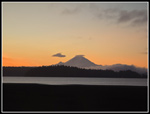 Mt. Rainier Near Sunrise |
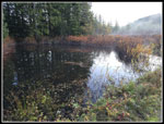 Swamp At The Start |
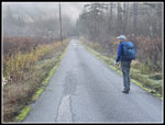 Gary And Misty Morning |
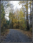 Fallen Leaves |
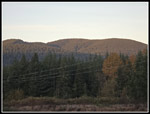 East Tiger Mountain |
 Golden Leaves |
 Leaves & A Creek |
 Mossy Rock |
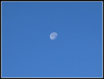 Nearly Full Moon |
 Heading Uphill |
 East Tiger Summit |
 Mt. Bakier In Sight |
 Olympic Mts. & Tiger 1 |
 More Fall Country |
 Gary Near The Top |
 Mt. Rainier |
 Bandera & Granite Mts. |
 Chimney Rock |
 Mt. Teneriffe |
 Mt. Hinman & Big Snow |
 Mt. Baker |
 Three Fingers Mountain |
 Debbie Anschell |
 Glacier Peak |
 Heading Down |
 Summit Towers |
 Gary In Sunshine |
 Back In Shade |
 Full Of Golden Leaves |
 My Side Trip |
 Upper Bridge |
 2+ Miles To Go |
 More Colorful Leaves |
 Back To Big Trees |
 One Mile Left |
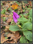 Foxglove |
 Almost Back |
Trips - 2025
Home