04-18-26
Kim
was free for a hike now that
the April 15th tax deadline passed by. I did a 13 miles hike the day
before so a shorter hike was what each of us needed. I wanted to get
away from local I-90 hikes so I suggested a trip up to Chuckanut
Mountain south of Bellingham. We had hiked that area before and enjoyed
it. I put together an unusual route where we would start and end at the
highest point of the day. We had a big drop to start and a big climb to
end the day. The base loop would be 6 miles with an optional mile extra
if we went to and around Fragrance Lake. We met in Shoreline at 7:00 am
and headed north. Unlike some trips up there during the winter it was
well past sunrise when we met. The drive was easy enough and we exited
I-5 onto Chuckanut Drive. 16 mile later we turned onto the HiLine Road.
We have done several hikes starting at the Two Dollar trailhead. This
time we went by and 3.5 miles more to the end of the road at the Cyrus
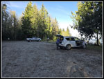
Gates Overlook. There were three cars at the Two Dollar Trailhead and
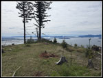
only one at the Overlook. We arrived at 8:35 am. It was cool in the mid
40s but would warm up nicely. From the Overlook it was clear enough to
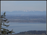
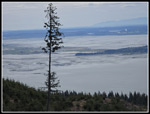
see the towers of Vancouver and Burnaby in Canada. We started at 8:44
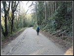
am by heading down the road.
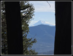
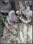
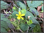
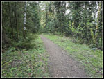
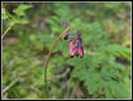
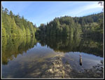
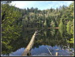
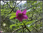
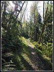
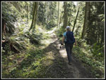
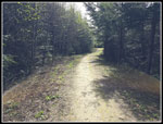
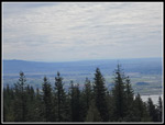
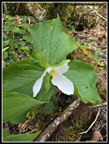
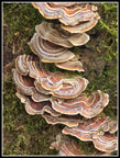
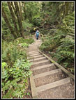
I hoped that doing the road early in the morning would see less car traffic than in the afternoon. That worked out. A short way down the road switched back to meet the ridge trail. From there we had a narrow view through trees to Mt. Baker and the Twin Sisters Range. It was a bit hazy but still a good view. I hope it would be clearer when we reached Burnout Knob. At the open gate we turned off the road onto an old road that is more like a wide trail now. No cars are allowed but we did see two mountain bikers pedaling up. The descent was very green. Just after leaving the ridge Kim noticed a very nice display of turkeytail fungus. I have seen a lot of very fresh ones the past couple of weeks. We also saw a yellow violet just before leaving the road. On the road/trial down to to Fragrance Lake we saw some blooming trillium and bleeding hearts. So far we had seen some wildflowers but few of each. At the lake junction we decided to head on over. It is only about .20 miles to the lake. There were just a couple groups at the lake at 9:42 am. The lake level was much higher than on my visit in mid January. We took a break at a spot on the shore and then did a counterclockwise loop around the lake.
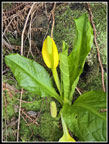
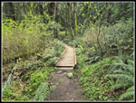
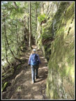
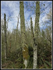
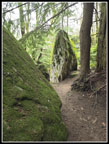
Over the past few years the parks people have put in bridges and boardwalks to avoid the spots that used to be muddy. We did see some bright yellow skunk cabbage. One group was at the viewpoint on the backside of the lake. Once across the outlet, the trail hugs a tall and steep sandstone wall. It is a good precursor for the Rock Trail we would hike later. The sandstone with pits and layers is always interesting to view. At the end of our loop, we crossed a wetland on a boardwalk that was lined with more skunk cabbage. That short .20 mile trail brought us back to the road/trail we had hiked earlier. We turned right and proceeded along for a few minutes then turned off left onto the South Lost Lake Trail. We quickly crossed the very steep mountain biking trail that drops from Cyrus Gates Overlook to Chuckanut Drive. The trail continues on gaining elevation slowly and sometimes steeply. The forest is very green and scenic. We saw some salmonberry bushes that had flowers and the start of berries on the same branches. This trail was very quiet in the morning. We would see people later but the morning was mostly solitude. At long last we topped out and the trail dripped a bit to a junction. We went straight while the South Lost Lake Trail turned to the left. The unsigned trail was a narrow boot path almost exactly 8 years ago when Kim and I hiked it for the first time.
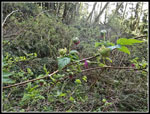
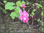
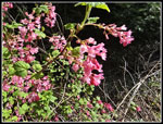
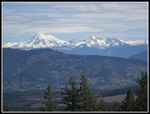
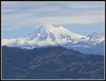
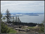
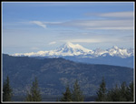
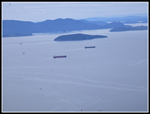
The trail leaves Larrabee State Park and meets a logging road. This area was clearcut a dozen years or so ago. There were several red current bushes in full bloom along here. We turned left on a spur that goes to a great view to the east. Samish Lake is below and Mt. Baker is right in your face. Baker looked great in the morning light. Over the peak were white clouds and blue sky. It was mostly blue over our heads. We took some photos and headed back to the main road. A left turn took us to Burnout Knob. We arrived at 12:08 pm. We had the Knob to ourselves. A group of bikers were at a previous high spot. The views were pretty good. It was hazy to the south though I could barely make out Mt. Rainier. Otherwise it was mostly clear. We had ships anchored below us. We saw several groups of large raptors that were likely juvenile eagles. What was most noticeable were the bugs. We had flying bugs at the trailhead and they were just as bad here. I guess they were mosquitoes though they were not biting. I do have a few dozen photos that have a lot of black spots on them. It may be too much work to clean them up to add to this report. I have never seen a swarm here in summer let alone in April. On the plus side we had a light but steady breeze keeping them somewhat at bay. We had a long lunch break here with plenty of sunshine.
We finally packed up and headed back at 1:41 pm. We hiked back to the junction with the South Lost Lake Road and turned right heading downhill. We saw bleeding hearts, trillium, and spring beauty in bloom. We were passed by an ATV with a park ranger riding it. She stopped a few minutes later to cut out a series of logs across the trail. We had earlier discussed if rangers used ATVs on the roads turned trails in the park. The answer is "yes". She noted they need to keep the road/trails open for emergencies and rescues. The next junction was our ticket back to the trailhead. We turned left and uphill on the Rock Trail. The Rock Trail was completed in 2014 and I hiked it for the first time on 5-17-15. I have been back many times in the intervening 11 years. In the first years I seldom saw more than one or two groups. Now it is much more popular. The crazy upper trail design and beauty of the sandstone walls plus the wildflowers with moss and ferns lower down is spectacular.
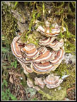
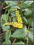
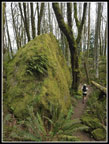
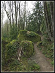
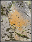
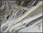
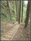
We saw skunk cabbage and salmonberry flowers right at the start then another great turkeytail display. There are staircases lower down mixed with a winding switchbacking trail. Bleeding hears were the next flower and then more trillium and Oregon grape. We heard two woodpeckers but could not see them. Lots of large and smaller rocks have fallen off the cliffs above and they are now covered with moss and ferns. Some big rocks are solid green in color. More than half way up the terrain changes. The trail reaches the base of the sandstone walls. Water trickles down the moss creating some yellow and orange colors. The trail used to be narrow in spots and has been widened. It feels much safer now.The route drops to avoid cliffs sand climbs again. In one spot the rock wall overhangs the trail. It is more than vertical. The route ends at a series of 8 or 9 steep staircases. They climb a ridiculously steep slope. Why did someone thing to build a trail here? I am glad that they did. After the last of the huffing and puffing we reached the top. We were now just a few minutes from the trailhead. We arrived back at Cyrus Gates Overlook at 3:47 pm. The lot was mostly full now. I went over to the viewpoint and hazy nearly hid Vancouver now. We were soon on our way home.
For the day we hiked 7 miles with about 1500' of elevation gain. Though the numbers were low, there were enough steep sections to make this a very good workout. The wildflowers were good and the views spectacular. Throw in a lake in forest and the Rock Trail and it added up to a very nice day in mountains within a mile of an inlet of the Pacific Ocean. For the two days, I hiked 20 miles with 3400' of gain. I was plenty worn out the next day. This was near peak for the tulips near Mt. Vernon and we paid the price driving home. The drive home was more than half an hour longer than the morning drive. It was well worth the stop and go driving as we had a really nice day on the trail.
Click on thumbnails to get
larger pictures.
Trips - 2026
Home
I hoped that doing the road early in the morning would see less car traffic than in the afternoon. That worked out. A short way down the road switched back to meet the ridge trail. From there we had a narrow view through trees to Mt. Baker and the Twin Sisters Range. It was a bit hazy but still a good view. I hope it would be clearer when we reached Burnout Knob. At the open gate we turned off the road onto an old road that is more like a wide trail now. No cars are allowed but we did see two mountain bikers pedaling up. The descent was very green. Just after leaving the ridge Kim noticed a very nice display of turkeytail fungus. I have seen a lot of very fresh ones the past couple of weeks. We also saw a yellow violet just before leaving the road. On the road/trial down to to Fragrance Lake we saw some blooming trillium and bleeding hearts. So far we had seen some wildflowers but few of each. At the lake junction we decided to head on over. It is only about .20 miles to the lake. There were just a couple groups at the lake at 9:42 am. The lake level was much higher than on my visit in mid January. We took a break at a spot on the shore and then did a counterclockwise loop around the lake.
Over the past few years the parks people have put in bridges and boardwalks to avoid the spots that used to be muddy. We did see some bright yellow skunk cabbage. One group was at the viewpoint on the backside of the lake. Once across the outlet, the trail hugs a tall and steep sandstone wall. It is a good precursor for the Rock Trail we would hike later. The sandstone with pits and layers is always interesting to view. At the end of our loop, we crossed a wetland on a boardwalk that was lined with more skunk cabbage. That short .20 mile trail brought us back to the road/trail we had hiked earlier. We turned right and proceeded along for a few minutes then turned off left onto the South Lost Lake Trail. We quickly crossed the very steep mountain biking trail that drops from Cyrus Gates Overlook to Chuckanut Drive. The trail continues on gaining elevation slowly and sometimes steeply. The forest is very green and scenic. We saw some salmonberry bushes that had flowers and the start of berries on the same branches. This trail was very quiet in the morning. We would see people later but the morning was mostly solitude. At long last we topped out and the trail dripped a bit to a junction. We went straight while the South Lost Lake Trail turned to the left. The unsigned trail was a narrow boot path almost exactly 8 years ago when Kim and I hiked it for the first time.
The trail leaves Larrabee State Park and meets a logging road. This area was clearcut a dozen years or so ago. There were several red current bushes in full bloom along here. We turned left on a spur that goes to a great view to the east. Samish Lake is below and Mt. Baker is right in your face. Baker looked great in the morning light. Over the peak were white clouds and blue sky. It was mostly blue over our heads. We took some photos and headed back to the main road. A left turn took us to Burnout Knob. We arrived at 12:08 pm. We had the Knob to ourselves. A group of bikers were at a previous high spot. The views were pretty good. It was hazy to the south though I could barely make out Mt. Rainier. Otherwise it was mostly clear. We had ships anchored below us. We saw several groups of large raptors that were likely juvenile eagles. What was most noticeable were the bugs. We had flying bugs at the trailhead and they were just as bad here. I guess they were mosquitoes though they were not biting. I do have a few dozen photos that have a lot of black spots on them. It may be too much work to clean them up to add to this report. I have never seen a swarm here in summer let alone in April. On the plus side we had a light but steady breeze keeping them somewhat at bay. We had a long lunch break here with plenty of sunshine.
We finally packed up and headed back at 1:41 pm. We hiked back to the junction with the South Lost Lake Road and turned right heading downhill. We saw bleeding hearts, trillium, and spring beauty in bloom. We were passed by an ATV with a park ranger riding it. She stopped a few minutes later to cut out a series of logs across the trail. We had earlier discussed if rangers used ATVs on the roads turned trails in the park. The answer is "yes". She noted they need to keep the road/trails open for emergencies and rescues. The next junction was our ticket back to the trailhead. We turned left and uphill on the Rock Trail. The Rock Trail was completed in 2014 and I hiked it for the first time on 5-17-15. I have been back many times in the intervening 11 years. In the first years I seldom saw more than one or two groups. Now it is much more popular. The crazy upper trail design and beauty of the sandstone walls plus the wildflowers with moss and ferns lower down is spectacular.
We saw skunk cabbage and salmonberry flowers right at the start then another great turkeytail display. There are staircases lower down mixed with a winding switchbacking trail. Bleeding hears were the next flower and then more trillium and Oregon grape. We heard two woodpeckers but could not see them. Lots of large and smaller rocks have fallen off the cliffs above and they are now covered with moss and ferns. Some big rocks are solid green in color. More than half way up the terrain changes. The trail reaches the base of the sandstone walls. Water trickles down the moss creating some yellow and orange colors. The trail used to be narrow in spots and has been widened. It feels much safer now.The route drops to avoid cliffs sand climbs again. In one spot the rock wall overhangs the trail. It is more than vertical. The route ends at a series of 8 or 9 steep staircases. They climb a ridiculously steep slope. Why did someone thing to build a trail here? I am glad that they did. After the last of the huffing and puffing we reached the top. We were now just a few minutes from the trailhead. We arrived back at Cyrus Gates Overlook at 3:47 pm. The lot was mostly full now. I went over to the viewpoint and hazy nearly hid Vancouver now. We were soon on our way home.
For the day we hiked 7 miles with about 1500' of elevation gain. Though the numbers were low, there were enough steep sections to make this a very good workout. The wildflowers were good and the views spectacular. Throw in a lake in forest and the Rock Trail and it added up to a very nice day in mountains within a mile of an inlet of the Pacific Ocean. For the two days, I hiked 20 miles with 3400' of gain. I was plenty worn out the next day. This was near peak for the tulips near Mt. Vernon and we paid the price driving home. The drive home was more than half an hour longer than the morning drive. It was well worth the stop and go driving as we had a really nice day on the trail.
 Cyrus Gates Overlook |
 Vancouver, BC |
 Framed Mt. Baker |
 Turkeytail Fungus |
 Hiking Down The Road |
 Yellow Violets |
 Road Turned Trail |
 First Bleeding Heart |
 Fragrance Lake |
 First Skunk Cabbage |
 Boardwalk |
 Other Side Of Lake |
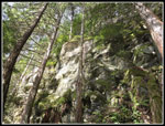 Sandstone Wall |
 Kim On Trail |
 Salmonberry Flower |
 Sunshine Ahead |
 Shade & Sunshine |
 Salmonberries |
 Road To Burnout Knob |
 Red Currant Flowers |
 Red Currant Bush |
 Mt. Baker Viewpoint |
 Mt. Baker Close Up |
 On Burnout Knob |
 Tide Is Out |
 Mt. Rainier |
 Baker From Burnout |
 Bugs Abound |
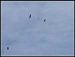 Big Birds Overhead |
 Leaving Burnout Knob |
 Mossy Pattern |
 Trillium |
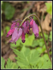 Colorful Bleeding Hearts |
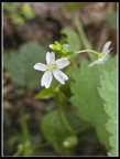 Spring Beauty |
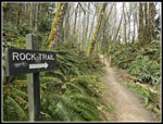 The Rock Trail |
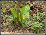 Another Skunk Cabbage |
 Great Turkeytails |
 Last Turkeytail |
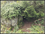 Cave |
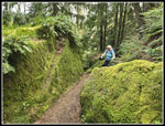 Kim & Mossy Rocks |
 Long Staircase |
 Oregon Grape |
 Runner & Mossy Rock |
 Rocks Along Trail |
 Tall Thin Rock |
 Colored Lichen |
 Sandstone Close Up |
 The Many Staircases |
Trips - 2026
Home