Home
I first hiked to Norway Pass and Mount Margaret in the late 1980s. It was only about 9 years after the eruption and the devastation was hard to describe. Fortunately I took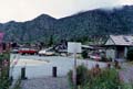 my camera along to document the scene. Throughout this report you will
find thumbnail photos. Click on them to get a larger picture. I had already
climbed Mount St Helens several times before I ventured to the north side
of the mountain. I had a birds eye view of the destruction from the crater
rim but it still did not prepare me for what I saw. What
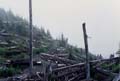
until recently had been dense forest was now masses of silvered logs covering
the ground. The heat and wind of the pyroclastic flow from the eruption knocked
down all the trees and burned off all the limbs and bark. A few silvered
poles were all that still stood. Small green vegetation was coming back.
The largest trees were two to three feet tall. There were a few trees as
much as ten feet tall. I can only guess that they were several feet tall
and covered with snow when the eruption hit. The snow and their short stature
may have allowed them to survive. Now they were by far the tallest trees
in sight. By that time the Norway Pass trailhead had been rebuilt with a
new rest room. On this trip I came in from the north. I hiked up the Norway
Pass trail on Saturday then drove around the east side of the mountain to
the Climbers Bivouac. There I joined friends for a hike to the summit on
Sunday. Now, back to the Norway Pass trailhead.
my camera along to document the scene. Throughout this report you will
find thumbnail photos. Click on them to get a larger picture. I had already
climbed Mount St Helens several times before I ventured to the north side
of the mountain. I had a birds eye view of the destruction from the crater
rim but it still did not prepare me for what I saw. What
until recently had been dense forest was now masses of silvered logs covering
the ground. The heat and wind of the pyroclastic flow from the eruption knocked
down all the trees and burned off all the limbs and bark. A few silvered
poles were all that still stood. Small green vegetation was coming back.
The largest trees were two to three feet tall. There were a few trees as
much as ten feet tall. I can only guess that they were several feet tall
and covered with snow when the eruption hit. The snow and their short stature
may have allowed them to survive. Now they were by far the tallest trees
in sight. By that time the Norway Pass trailhead had been rebuilt with a
new rest room. On this trip I came in from the north. I hiked up the Norway
Pass trail on Saturday then drove around the east side of the mountain to
the Climbers Bivouac. There I joined friends for a hike to the summit on
Sunday. Now, back to the Norway Pass trailhead.
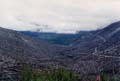
The trail started out with a moderate elevation gain. With no trees at all the view began immediately and improved as I ascended. The destruction was total. Downed trees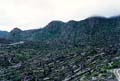 filled the view in all directions. The flow had gone right over the ridge
I was climbing, crossed the valley below and continued right up the ridge
to the north. Most interesting was the view to the west. There was a distinct
end to the pyroclastic flow. A line ran up the ridge. To the east of the line
all the trees were knocked down. To the west they were all still standing.
The trail was in very good shape. Many logs that fell across the trail had
been cut. The tread that had once been soft forest needles was now sandy with
ash. The day was overcast and the ground was moist with dew. This minimized
the dust. I expect just walking would have kicked up significant dust on a
hot dry day. The trail switchbacked and traversed up the slope of the ridge.
It rounded the ridge and began contouring towards Norway Pass. There was only
one car in the lot when I left so I had the trail nearly to myself. At Norway
Pass Spirit Lake comes into view. When the
filled the view in all directions. The flow had gone right over the ridge
I was climbing, crossed the valley below and continued right up the ridge
to the north. Most interesting was the view to the west. There was a distinct
end to the pyroclastic flow. A line ran up the ridge. To the east of the line
all the trees were knocked down. To the west they were all still standing.
The trail was in very good shape. Many logs that fell across the trail had
been cut. The tread that had once been soft forest needles was now sandy with
ash. The day was overcast and the ground was moist with dew. This minimized
the dust. I expect just walking would have kicked up significant dust on a
hot dry day. The trail switchbacked and traversed up the slope of the ridge.
It rounded the ridge and began contouring towards Norway Pass. There was only
one car in the lot when I left so I had the trail nearly to myself. At Norway
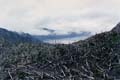
Pass Spirit Lake comes into view. When the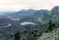 eruption occurred, huge volumes of melted ice flowed into the lake. A bathtub
ring showed how the water surged down the lake leaving a mark far up on the
surrounding ridges. Trees and mud dammed up the north end of the lake
and it left a much deeper Spirit Lake. Thousands of logs covered the surface
of the lake. From the summit it was difficult to tell what was shore and what
was logs floating on the water. From Norway Pass it was easy to tell. The
north end of the lake, just below the pass, was completely covered by logs.
It appeared that you could simply walk right across the lake. The Independence
Pass trail goes south from the pass to another trailhead. This section
looks down at the lake and up to the gaping hole in the north side of the
mountain. Hiking this trail is still on my "to do" list. From the pass the
trail contours down the end of a valley and ascends up the other side.
eruption occurred, huge volumes of melted ice flowed into the lake. A bathtub
ring showed how the water surged down the lake leaving a mark far up on the
surrounding ridges. Trees and mud dammed up the north end of the lake
and it left a much deeper Spirit Lake. Thousands of logs covered the surface
of the lake. From the summit it was difficult to tell what was shore and what
was logs floating on the water. From Norway Pass it was easy to tell. The
north end of the lake, just below the pass, was completely covered by logs.
It appeared that you could simply walk right across the lake. The Independence
Pass trail goes south from the pass to another trailhead. This section
looks down at the lake and up to the gaping hole in the north side of the
mountain. Hiking this trail is still on my "to do" list. From the pass the
trail contours down the end of a valley and ascends up the other side.
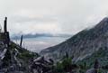
At higher elevations Mount Rainier and Mount Adams are seen. On my first trip here it was too cloudy to see either one. A little farther along the trail is a view down to Grizzly Lake. Once it was a backpacking destination deep in the forest.
When I hiked by it was completely in the open and surrounded by logs. Very
noticeable in all my photos was the green ground cover. It made such a startling
contrast to the silvered trees and logs. In fact, in areas above the tree
line it looked almost "normal". My biggest problem was trying to identify
Mount Margaret. The trail traversed below a peak which was easily climbable.
I headed off trail and quickly reached the top. This was my lunch spot and
turnaround point. Views were improving but not enough to see into the crater.
As it turned out this was not Mount Margaret. On my next trip with my friend
Gary we continued on to the real Mount Margaret. Margaret is a long ridge
of summits. The peak I went to the first time was one lone summit. It was
actually a much nicer place to stop. On my second trip it was clear and we
had much better views of the mountain. I will be interested in going back
in the future to see how time heals this area. It certainly was impressive
in the aftermath of the great eruption.
Grizzly Lake. Once it was a backpacking destination deep in the forest.
When I hiked by it was completely in the open and surrounded by logs. Very
noticeable in all my photos was the green ground cover. It made such a startling
contrast to the silvered trees and logs. In fact, in areas above the tree
line it looked almost "normal". My biggest problem was trying to identify
Mount Margaret. The trail traversed below a peak which was easily climbable.
I headed off trail and quickly reached the top. This was my lunch spot and
turnaround point. Views were improving but not enough to see into the crater.
As it turned out this was not Mount Margaret. On my next trip with my friend
Gary we continued on to the real Mount Margaret. Margaret is a long ridge
of summits. The peak I went to the first time was one lone summit. It was
actually a much nicer place to stop. On my second trip it was clear and we
had much better views of the mountain. I will be interested in going back
in the future to see how time heals this area. It certainly was impressive
in the aftermath of the great eruption.
I first hiked to Norway Pass and Mount Margaret in the late 1980s. It was only about 9 years after the eruption and the devastation was hard to describe. Fortunately I took
my camera along to document the scene. Throughout this report you will
find thumbnail photos. Click on them to get a larger picture. I had already
climbed Mount St Helens several times before I ventured to the north side
of the mountain. I had a birds eye view of the destruction from the crater
rim but it still did not prepare me for what I saw. What
until recently had been dense forest was now masses of silvered logs covering
the ground. The heat and wind of the pyroclastic flow from the eruption knocked
down all the trees and burned off all the limbs and bark. A few silvered
poles were all that still stood. Small green vegetation was coming back.
The largest trees were two to three feet tall. There were a few trees as
much as ten feet tall. I can only guess that they were several feet tall
and covered with snow when the eruption hit. The snow and their short stature
may have allowed them to survive. Now they were by far the tallest trees
in sight. By that time the Norway Pass trailhead had been rebuilt with a
new rest room. On this trip I came in from the north. I hiked up the Norway
Pass trail on Saturday then drove around the east side of the mountain to
the Climbers Bivouac. There I joined friends for a hike to the summit on
Sunday. Now, back to the Norway Pass trailhead.The trail started out with a moderate elevation gain. With no trees at all the view began immediately and improved as I ascended. The destruction was total. Downed trees
filled the view in all directions. The flow had gone right over the ridge
I was climbing, crossed the valley below and continued right up the ridge
to the north. Most interesting was the view to the west. There was a distinct
end to the pyroclastic flow. A line ran up the ridge. To the east of the line
all the trees were knocked down. To the west they were all still standing.
The trail was in very good shape. Many logs that fell across the trail had
been cut. The tread that had once been soft forest needles was now sandy with
ash. The day was overcast and the ground was moist with dew. This minimized
the dust. I expect just walking would have kicked up significant dust on a
hot dry day. The trail switchbacked and traversed up the slope of the ridge.
It rounded the ridge and began contouring towards Norway Pass. There was only
one car in the lot when I left so I had the trail nearly to myself. At Norway
Pass Spirit Lake comes into view. When the
eruption occurred, huge volumes of melted ice flowed into the lake. A bathtub
ring showed how the water surged down the lake leaving a mark far up on the
surrounding ridges. Trees and mud dammed up the north end of the lake
and it left a much deeper Spirit Lake. Thousands of logs covered the surface
of the lake. From the summit it was difficult to tell what was shore and what
was logs floating on the water. From Norway Pass it was easy to tell. The
north end of the lake, just below the pass, was completely covered by logs.
It appeared that you could simply walk right across the lake. The Independence
Pass trail goes south from the pass to another trailhead. This section
looks down at the lake and up to the gaping hole in the north side of the
mountain. Hiking this trail is still on my "to do" list. From the pass the
trail contours down the end of a valley and ascends up the other side. At higher elevations Mount Rainier and Mount Adams are seen. On my first trip here it was too cloudy to see either one. A little farther along the trail is a view down to
Grizzly Lake. Once it was a backpacking destination deep in the forest.
When I hiked by it was completely in the open and surrounded by logs. Very
noticeable in all my photos was the green ground cover. It made such a startling
contrast to the silvered trees and logs. In fact, in areas above the tree
line it looked almost "normal". My biggest problem was trying to identify
Mount Margaret. The trail traversed below a peak which was easily climbable.
I headed off trail and quickly reached the top. This was my lunch spot and
turnaround point. Views were improving but not enough to see into the crater.
As it turned out this was not Mount Margaret. On my next trip with my friend
Gary we continued on to the real Mount Margaret. Margaret is a long ridge
of summits. The peak I went to the first time was one lone summit. It was
actually a much nicer place to stop. On my second trip it was clear and we
had much better views of the mountain. I will be interested in going back
in the future to see how time heals this area. It certainly was impressive
in the aftermath of the great eruption.