7-13-02
The loop around Esmerelda Peaks
is an old favorite. I had done it once in each direction though it had been
at least 8 years since the last trip. Previously I had done it alone land
so needed to walk the 1 1/2 miles from the De Roux to the Ingalls trailheads.
This time it was a Mountaineer trip and we car shuttled the road section.
The forecast was for temperatures in the high 80s to low 90s and possible
thundershowers. We met at 8:30 and had the cars positioned and were ready
to hike by about 9:00. We did the loop counter clockwise starting at the Ingalls
trailhead. The trail up Esmerelda basin is very gently graded. In 3 1/2 miles
to Fortune Pass we gained 1750' The pass is the high point of the trip at
6000'. There are numerous creek crossings but none are especially difficult.
A walking stick or poles helps. Flowers are now nearing their peak. Columbine,
paintbrush, lupine, and many others are all along the trail. The stars of
the valley are shooting stars. They are blooming by the acre. I have never
seen so many of them on one hike. The trail to the pass is nearly snow free.
There are a few patches just below the pass but they are not impediments and
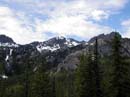
will be gone in a week or so. Views from the pass are across to Esmerelda
Peaks, east to Iron and Bill, and northwest to Mt. Daniel. Hawkins is just
across the valley to the southwest.
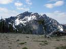
After all the group arrived we had some food and water and prepared for the 1000' drop to the Fortune Creek road. The temperature was rising quickly but at least we had all but 450' of gain out of the way early. The trail down is seldom used but in surprisingly good shape. There was evidence of recent log cutting. In fact, no logs remain uncut across the trail in this section. It is also completely snow free. From the road it is once again uphill, about 1 mile to Gallagher Head Lake gaining 450'. There is some snow on this section but not enough to slow us down. Unfortunately, it wasn't enough to stop a group of 4 wheel ATVs from speeding by. There is nothing like the noise and smell they put out when you are 5 miles up a trail. At one point the road splits. The right fork looks just like the road we had been hiking. The left fork seems to agree with the map. We debated then chose the right fork. In a short distance they seemed to come back together. At this point I sped up and moved well out ahead of the group. Nearing the lake the terrain left forest and became much more meadow like. Small streams wound through the meadow and wildflowers were growing in profusion. Once again the shooting stars were everywhere. The way flattens out at Gallagher Head Lake. By now it was very warm. I headed down to the lake, took off my boots, and soaked my feet. That was just the thing to cool me down. Shortly the rest of the gang arrived. Two people and their horses were on the other side of the lake. They were the first people we had seen since leaving the trailhead. From the lake it is all down hill. With this in mind we had a leisurely one hour lunch. Esmerelda Peaks are on one side and Hawkins on the other. In between are the lake and the meadows. This really is a beautiful spot. It is ridiculous that the road is not gated at this point or before. At the very least it should be gated just before the lake and meadows. Most drivers stay on the road but one idiot can destroy the meadows for years to come.
After our long break it was tough to get moving again. Clouds had thickened while we loafed and the chance of thundershowers seemed more and more likely. Since this is a horse trail it is graded very gently. From the lake it drops down into a valley. The trail takes a number of long switchbacks to slowly drop on down. This is longer than most hiking trails but is very easy on the knees when descending. Unlike the trail on the Esmerelda side the De Roux trail has not had any logs cut. We had quite a few to climb over but none were a serious problem. The worst one has caused hikers to cut a switchback to avoid crossing it twice. The damage will be fairly severe if the logs are not cut soon. We dropped into the valley and hiked down to the end. Near the end is the debris from an avalanche. Many trees were broken off and deposited at the bottom of the slope. About 100' of the trail is buried. Fortunately there is not much brush over here and we had no trouble going around and finding the trail again. A trail crew is needed here as soon as possible. At this point the trail crosses De Roux Creek. The old log which had been there for years is gone. The creek is not too big to ford though you would get wet. There is one small log across. It was too skinny for me to stay balanced while crossing. With my poles I did get across. By extending the pole to grab onto everyone crossed with dry feet. At this point we were passed by about 8 horses from Camp Wahoo. We let them pass but they went down at about our pace. We had lots of very fresh horse droppings all the way back down. After crossing the creek light rain began. Thunder joined in. The rain was actually nice on such a warm day. Nobody put on any rain gear. In any event it did not last very long. The final 3 miles was a very nice walk in the forest. The thick forest of the De Roux valley is much different from the mostly open Esmerelda valley on the other side of Esmerelda Peaks. Nice flowers here as well but different from the first half of the trip. I was surprised to see a brand new bridge at the De Roux Creek crossing. The old log is still there and worked great. Now there is a big new bridge. I was even more surprised at the Teanaway River crossing. An even bigger new bridge is in place. This one even has cement foundations. The old bridge broke in half at least a dozen years ago. I had been up De Roux just a few years ago so the bridges must have gone in last summer. From the crossing it's only a few hundred feet back to the cars. The totals on the day were 10 miles and 2200' gained. There were great wildflowers, nice views, and a nice small lake. The day was hot but with some clouds and showers it was not too unbearable. I need to make sure I don't wait another 8 years to do this trip again.
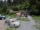
Esmerelda Trailhead |
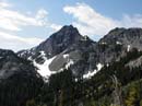
Esmerelda Peaks |
More Esmerelda |
Hawkins From Pass |
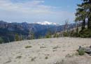
Mt. Daniel From Pass |
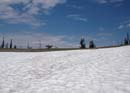
Snow Near Pass |
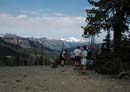
Group At Pass |
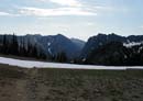
Peaks To The East |
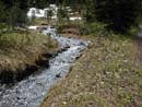
Creek Near Lake |
Photo Page 2
Home