6-08-02
Usually in June a trip to the
East slopes means better weather. This morning it was partly sunny in Seattle,
raining at Snoqualmie Pass, Snowing at Stevens, and raining at Blewett Pass.
Even though the long drive east didn't look very promising I was on the
road by 7:30. Once past Issaquah the rain began. Visibility beyond North
Bend was about 50 feet. I don't know when I have seen so much water thrown
up by traffic. By the time I reached Snoqualmie Pass it was snowing. So much
for early June. I exited just past Cle Elum and headed north. By now there
was a little sun between the clouds. The Iron Creek road turns off to the
left 2.3 miles north of Mineral Springs Resort. It is snow free to the trailhead.
The creek crossing near the parking lot looks much worse than it is. My car
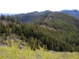
had no trouble at all. The trail to Iron Bear Pass is virtually snow free.
There were only a few small patches and they will be gone in a few days.
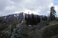
The pass is also snow free. There was almost no wind here for a change. Lots
of clouds but no rain. At the pass I turned right and headed up the trail
to Iron Bear Peak. The trail is in great shape. There was one downed log
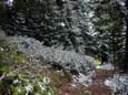
but it was cut while I was hiking beyond it. Near the top the trees had a
fresh coat of snow. It did not look like early June far to the east of the
Cascade crest. I set my altimeter to 3600' at the trailhead and it showed
5480' on top. It is about 3 1/2 miles up with about 1900' of gain. I was
the first person on the trail but I knew there would be plenty more. I enjoyed
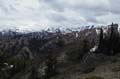
a brief summit stay though the views were minimal. Even Miller Peak, just
across the valley was largely in the clouds. From the summit the trail switchbacks
down the north side of the mountain. This heavily forsested section is always
the last to melt out. This year is no exception. There is plenty of now still.
Following the trail down from the summit is not possible. Instead, I followed the east ridge down. The north side of the ridge is snow covered. The top and south side is bare. I went down the ridge then contoured around a rock rib to get back on the ridge. Near the low point the County Line trail intersects the Teanaway Ridge trail I was on. The County Line contours around a high point then drops down to a low pass where a road from Shaser Creek comes in. Instead of following this trail towards Miller Peak, I went straight up the unnamed high point above. At the top I had some nice views and lots of solitude. On so many of my Spring scrambles I have not seen any people. Today would be an exception. I spent over an hour and a half on top. Soon I could hear voices of people over on Iron Bear. I also heard several motorcycles. They must have been the ones who cut the downed log. After a nice long lunch and some reading I headed back to Iron Bear. Near the top I passed a group of about 8 plus 5 more on the summit. When I first reached the top it was 40 degrees. By now it had risen to 50 degrees. The views had also improved. Most of the Teanaway peaks were out of the clouds. Only the top of Stuart and all but the top of Rainier were hidden. I dropped back down to Iron Bear Pass and continued on the Teanaway Ridge trail. I have meant to hike this trail for many years but had never done so. The trail is in great shape. I followed it for over 1 1/2 miles and found no mud and no logs down. I would like to spend a day and follow it alll the way to Red Top lookout. The trail has lots of ups and down. I calculated 800' elevation gain in the 1 1/2 miles. I stopped when I finally came out of the trees and had nice views. I could see Earl and Navaho Peaks. and also out to the east. There were at least 4 rain squalls going on around me. One was to the east and seemed to be heading my way.
At this point I headed back. The Teanaway Ridge trail south had no snow. Once back at the pass it was all down hill. The first 1 1/2 miles to the pass had many flowers nearing there peak. I recognized the Indian Paintbrush and Balsam Root but not many of the others. Two more motorcycles came up while I was going down. It will be at least 3+ weeks before the trail down from Iron Bear Peak will be melted out enough for the cycles. In the mean time, it is a great time for hikers comfortable traversing moderately steep stretches of snow covered trail. By steep I mean snow covering the trail and creating a 30+ degree angle to cut steps in. The totals for the day were 11 miles and 3000' of gain.
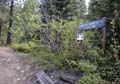
The Trailhead |
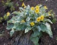
Balsamroot |
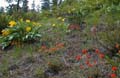
Wildflowers |
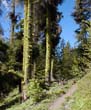
Mossy Trees |
Iron Bear Pass |
Fresh Snow |
Teanaway Peaks |
Miller Peak |
Home