8-17-18-02
This was my 50th trip of the year
but only my first backpack. Gary and Dave decided on the trip and invited
me along. I have wanted to hike up to Peggy's Pond for many years but had
never done it. This trip had a little bit of everything. We had good trail,
poor trail, and abandoned trail. There was rock and snow, scrambling, glissading,
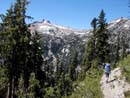
and spectacular views. The trail up to Squaw Lake is wide and gently graded.
There were several groups camped at the lake. The next section up to Cathedral
Pass breaks out of the forest into meadows and small tarns. Views begin
to open up across the valley towards Paddy Go Easy Pass and later The Cradle.
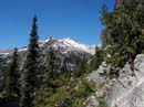
By the time we reached the pass it was getting to be fairly warm and the
sky was clear. Cathedral Pass is right below Cathedral Peak. I have seen
it many times from a distance but it is even more impressive close up. From
the pass the views are terrific. In addition to the previous views east are
added great views to the west. The route goes over the pass and drops toward
Deep Lake. At the first switchback the main trail goes to the left and the
way trail to Peggy's Pond continues to the right. The trail contours closely
around Cathedral Peak. Soon, views open up down to Deep Lake. The route is
a little sketchy in places. It's not too difficult but be prepared for a
little exposure. This is not where you want to take non-hiking friends if
you want to keep them as friends. The route loses about 220' and regains
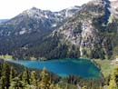
it by the time you reach Peggy's Pond. Before the pond the trail goes right
by the last remnants of what once was a cabin. The pond itself was nicer
than I expected. It sits just below Cathedral Peak. The area around it is
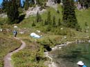
full of meadows and tarns. After about 5 1/2 miles we dropped our packs and
found a camp site. It was about 12:40 be this time and I was surprised to
see that there were only two other parties at the pond. A nice breeze was
blowing which hid the fact that the mosquitos were very thick. When the breeze
died down we found out the truth. Fortunately, by then, we had set up our
tents and had a refuge from the bugs. From our site we could see the East
Peak of Daniel.
After a late lunch and a little exploring around the pond, Gary and I set out for a little scrambling. We looked at the map and decided to head over to the ridge on the right side of the moraine and try for the two high points on the ridge. There is a saddle with point 6350 on the right and point 7081 on the left. The scramble to the saddle was lots of fun. The ridge is mostly cliffy but an easy route wove around them to the top. The view from 6350 was great. Daniel blocked the way to the west but everything else was open. Glacier Peak, Sloan, Monte Cristo were seen to the north. Stuart, Ingalls, South Ingalls, Fortune, Esmerelda, and Hawkins were to the East. To the south was Adams and the southeast ridge of Daniel. Cathedral Rock was just across from us. After dropping to the pass we continued up the other side to the top of Point 7081. It was unusual to be on a summit at over 7000' and to have another peak nearly 1000' higher right next to us. The snow route on the face of East Daniel was very clearly seen from our viewpoint. On the backside of Point 7081 was one of the most amazing waterfalls I have ever seen. It came off of the Lynch Glacier on Daniel and fell hundreds of feet in several falls before the climax, a twin vertical falls that must have been several hundred feet. We had a view that few if any other places would afford. We also saw two climbers who were descending Daniel via the Lynch Glacier. It looked like they were heading for our ridge before descending back towards Peggy's Pond. After taking many photos, we headed back down. Instead of descending the ridge with some loose scree near the top, we headed down the face of the point on rock and heather before turning back towards the saddle. This route gave us a number of standing glissades on small snowfields. From the pass we headed back to the camp site and had dinner. The breeze had died and the mosquitos were really thick. I put on all my rain gear and had only a little face showing. By 9:30 we called it a day.
In the morning we had breakfast and headed up the southeast ridge of Daniel. We had ice axes and were prepared to try the summit if the conditions were good. The ridge was alot of fun. It follows a climbers trail some of the way and is easy scrambling where the trail fades away. Higher up we had views down to Circle Lake. One party had managed to scramble off trail to the lake. It still had some ice in it. To the south we could see Adams, Rainier, and the Cascade crest. Summit Chief and Bears Breast were especially close. At about 7000' we neared the start of a long snow traverse towards the East Peak and decided that we would pass on the summit this day. This point is a great viewpoint in its own right. Instead of descending the ridge we scrambled down to the top of the snowfield below. The snow is actually the top of what's left of the Hyas Glacier. It was steep and fairly hard. I kicked steps away from the rocks to where I had a clear run down the snow. I sat down, lifted my feet, and away I went. The hard snow was a bouncy ride and less than a minute later I was down 600'. I didn't expect to have another long glissade so late this year. That one glissade alone would have made this trip a success. The rest of the way down the moraine was a mix of large slabs, snow and a little scree. We had lunch up in the moraine where the view was great and the bugs were nonexistent. Between when we arrived and that evening the valley filled up with hikers and climbers. There were at least 20 people by morning. On the way back we passed many tents. The bugs were as bad as ever so we broke camp as fast as possible. We then headed back on the route to Cathedral Pass. At the pass we finalized a plan Gary hatched several years ago. From the pass the ridge running away from Cathedral Rock is nearly flat. It has a trail that has not been on maps for quite some time. Gary had wanted to explore this ridge years ago then he found a map which showed that a trail did once exist. Near the other end of the ridge is where the abandoned Cascade Crest Trail use to go through. By following these two abandoned trails we hoped to complete a loop back to near Squaw Lake.
The ridge does have a trail and
it does have amazing views. Cathedral Rock is right behind and views are
in nearly every direction. We were too late for flowers but I bet they would
have been good a month ago. Our junction would be about 1 1/3 miles along.
After about a mile we were surprised to find a party of three up on a big
rock above the trail. They turned out to be trail volunteers who were very
knowledgeable about our route. They verified that the route did exist all
the way around. Armed with this knowledge we headed on and found the old
intersection with no trouble. The old Crest trail dropped steeply for several
hundred feet. We stopped for a break at a small lake which was a short distance
off the trail . From here the route continued at a steep rocky grade quickly
losing elevation. Farther down the tread improved as the grade eased. We
reached the Trail Creek Trail and turned left. 16 minutes later we made it
back to the Cathedral Pass Trail just below Squaw Lake. The last 2 1/2 miles
were a grind but back on easy trail. We were all beat when we returned. With
our first day extra scramble, Gary and I finished with about 17 miles and
5800' gained for the weekend. Dave had not been hiking this year and his
first trip was for about 15 miles with 4200' including pounding down that
abandoned trail. The scenery was some of the best I have seen. I hope to
get back there again soon.
Click on thumbnails to get larger pictures.
Photo Page 2
Home
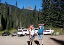
Gary & Dave At The Trailhead |
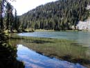
Squaw Lake |
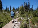
Meadows Near Cathedral Pass |
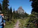
Cathedral Rock |
Circle Lake Falls |
Mt. Daniel |
Deep Lake |
Campsite |
Photo Page 2
Home