02-08-03
The Capitol Forest is an area that has long interested
me. It is a DNR owned working forest just like Tiger Mountain. Also like
Tiger it has a large network of trails throughout. It is also at a low elevation
which allows Winter hiking without much, if any, snow. My only previous attempt
ended quickly as one party member developed a blister after only about a
mile. Since then it has remained in my memory as a place to check out more
thoroughly. A Mountaineer hike gave me a perfect chance to join a group for
some exploring. Getting a newer map will solve alot of headaches. My old
Footsore book is often incorrect as some roads have been closed down and
many others have been created. I used Topozone.com and the map there is very
often wrong. Fortunately, John had a newer map and helped us find the trailheads.
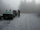
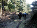
Instead of doing the 11 mile trail described in Footsore we opted to do a one way trip from a higher trailhead at Camp Wedekind to the summit and then down the regular Capitol Peak Trail to Falls Creek Campground. The Sherman Creek Valley Road no longer goes through to Falls Creek. A newer road from the opposite direction does. We met just off I-5 exit 95 near Little Rock and drove on the Falls Creek Campground. We left two cars and drove the other two to Camp Wedekind. The lower trailhead was dry and fairly warm. At the upper one everything was covered in frost. We were all in a hurry to get boots on and get moving to warm up. Both the trail up to the summit and the one down to Falls Creek are named Greenline #6. The first trail is also known as the Black Hills Crest Trail. Finding the start of the trail is not easy. All the trail starts and road intersections are poorly or not at all marked. Once you find the trail there are markings. One intersection is near a "Y" where you would need to know you must follow one of the roads for several hundred feet to pick up the trail again. All the trails we traveled were in very good condition. Mud was at a minimum and the grade was fairly gentle with a number of switchbacks.
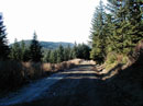
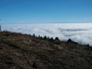
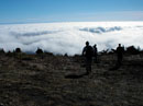
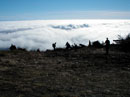
The Black Hills Crest trail ends up on a road. The trail down to Falls Creek is on the other side of the road. The road walk is about a half mile to the summit. the summit is full of towers. The view to the south and east is terrific. Rainier, Adams, and St. Helens are all visible. The clouds were about 500 feet below us but we were in bright sunshine. It was nice to be out in the sun while the whole Puget Sound Basin was shivering under the stagnant smog cover. After lunch we walked over to the other side of the towers and had a little view of the Olympics. From here on the whole route was down. The trail to Falls Creek is in excellent shape. Horses are banned in the Winter and the result is great tread with little mud. The way travels on a number of old logging railroad grades. Old overgrown roads are passed as well. The maps showed two active roads to cross but we actually crossed five or six. There is one nice metal bridge to cross. Below the last road crossing the trail leaves forest and enters an old clearcut. Looking back we could see the summit for the first time. We ended up in Falls Creek Campgrounds. As usual, there were no directions to get back to the cars. We took several turns in the campgrounds and ended up back on the main road a short distance from our cars. The last step was a nearly 8 mile drive back to the upper trailhead. From there John was able to navigate a shorter route out of the forest. From Camp Wedekind we drove back to Sherman Valley Campgrounds where we reached pavement for the rest of the drive out.
Capitol Forest is a nice low elevation alternative for snow free hiking in the Winter. With a good map I think I could find my way around. This will make a good option when Tiger Mountain is getting a little too monotonous.
Click on thumbnails to see larger pictures.
Photo Page 2
Home
Instead of doing the 11 mile trail described in Footsore we opted to do a one way trip from a higher trailhead at Camp Wedekind to the summit and then down the regular Capitol Peak Trail to Falls Creek Campground. The Sherman Creek Valley Road no longer goes through to Falls Creek. A newer road from the opposite direction does. We met just off I-5 exit 95 near Little Rock and drove on the Falls Creek Campground. We left two cars and drove the other two to Camp Wedekind. The lower trailhead was dry and fairly warm. At the upper one everything was covered in frost. We were all in a hurry to get boots on and get moving to warm up. Both the trail up to the summit and the one down to Falls Creek are named Greenline #6. The first trail is also known as the Black Hills Crest Trail. Finding the start of the trail is not easy. All the trail starts and road intersections are poorly or not at all marked. Once you find the trail there are markings. One intersection is near a "Y" where you would need to know you must follow one of the roads for several hundred feet to pick up the trail again. All the trails we traveled were in very good condition. Mud was at a minimum and the grade was fairly gentle with a number of switchbacks.
The Black Hills Crest trail ends up on a road. The trail down to Falls Creek is on the other side of the road. The road walk is about a half mile to the summit. the summit is full of towers. The view to the south and east is terrific. Rainier, Adams, and St. Helens are all visible. The clouds were about 500 feet below us but we were in bright sunshine. It was nice to be out in the sun while the whole Puget Sound Basin was shivering under the stagnant smog cover. After lunch we walked over to the other side of the towers and had a little view of the Olympics. From here on the whole route was down. The trail to Falls Creek is in excellent shape. Horses are banned in the Winter and the result is great tread with little mud. The way travels on a number of old logging railroad grades. Old overgrown roads are passed as well. The maps showed two active roads to cross but we actually crossed five or six. There is one nice metal bridge to cross. Below the last road crossing the trail leaves forest and enters an old clearcut. Looking back we could see the summit for the first time. We ended up in Falls Creek Campgrounds. As usual, there were no directions to get back to the cars. We took several turns in the campgrounds and ended up back on the main road a short distance from our cars. The last step was a nearly 8 mile drive back to the upper trailhead. From there John was able to navigate a shorter route out of the forest. From Camp Wedekind we drove back to Sherman Valley Campgrounds where we reached pavement for the rest of the drive out.
Capitol Forest is a nice low elevation alternative for snow free hiking in the Winter. With a good map I think I could find my way around. This will make a good option when Tiger Mountain is getting a little too monotonous.
Camp Wedekind |
Black Hills Crest Trail |
Road Walking |
Clouds Below |
Sunny Summit |
More Clouds |
Photo Page 2
Home