8-09-03
Over the years I have scrambled
or hiked to the top of all the Teanaway peaks except one. This one peak
has been the only blot on my record. Today I finally got to the top. DeRoux
Peak is not named on maps. It is not in Beckey's "Cascade Alpine Guide".
It is nearly unknown. The only place I have heard about it is in Mary Sutliff's
"Teanaway Country". A very vague route description for a scramble is included.
Armed with that vague description and a map I set out. It was forecast
to be 84 degrees in Cle Elum with a chance for afternoon thunder showers.
Not wanting to have a long ridge walk out with lightning flashing around
me I got a relatively early start. When I arrived at the DeRoux campgrounds
at 8:30 there were a number of campers but no other cars at the trailhead.
The North Fork Teanaway Road was in great shape and I had no traffic that
early. The trailhead is right next to Camp Wahoo where horse trips originate.
The horses are on the trail most weekends and motorcycles are also allowed.
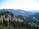
The trail is in fairly good shape but it is very dusty. Much of the way
is on a few inches of soft and loose dirt. Some of the switchbacks have
been torn to pieces by non-hiker traffic. These problems aside, the trail
makes many gentle switchbacks and has no steep sections.
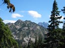
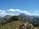
The trail begins by quickly crossing the Teanaway River on a very substantial bridge. This bridge has been here for 4 or 5 years and means no more crazy crossings on skinny logs. The next crossing of DeRoux Creek is also on a recently built bridge. Shortly after this crossing the trail splits. The right fork heads up to Gallagher Head Lake and the left fork begins to climb to the saddle above the Middle Fork Teanaway River. This trail is also the shortest way to the top of Koppen Mountain. The morning was already warm but not yet hot. I made very good time and reached the saddle at 2 1/2 miles in just over one hour. Now the fun began. The trail to the left goes up Koppen Mountain. Straight ahead drops down to the Middle Fork. I turned to the right and began to climb the slope. A short ways up I saw a very faint trail traversing under the south side of the ridge. There was a little tread but I was surprised to see only animal prints. Not a single boot pattern was seen. The ridge climbed then dropped and the trail met the ridge and dropped down to another saddle. It climbed again this time staying 70' or so below the ridge. Animal paths went up and down numerous times making it tough to stay on route. As the tread lessened it was a chore to keep walking along the steepening slope. I finally had enough and headed straight up to the ridge top. Near the top I found more tread. Travel along the top was much easier. The north side of the ridge is heavily forested up to and including the top. The south side is mostly open with some sparse trees and brush. This made the very top of the ridge tough to stay on. I often had to go below on the south side to get through.
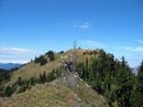
A short drop brought me to the third hump on the ridge. This one could be crossed by staying well below the ridge and making a long side hill traverse. That didn't look like much fun so I stayed on the ridge top. There were several very easy rock sections but mostly it was just a walk along the very top of the ridge. I managed to get around several difficult looking spots that turned out to be easy. Some tread showed up as I went from the north to the south side and back several times. From the top of the third hump I could see the fourth hump and the actual summit. The summit is really just the high point on a bare ridge top. By now it was getting hot and the rest of the way was out in the sun. The fourth hump was less steep and went quickly. The last part was just an open slope walk up. I reached the top at 11:15, about 2 1/2 hours from my start time.
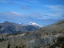
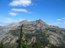
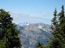
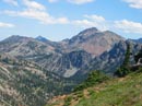
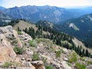
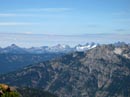
The view from the top is very nice. Hawkins Mountain is just across the valley of DeRoux Creek. This is the best view of Hawkins I have seen. Fortune Peak and Mt. Stuart are visible to the north. Koppen is east and Jolly Mountain is to the west. Mt. Rainier should have been visible but clouds covered all but the very bottom. The Cascade crest peaks very clear from HiBox, Three Queens, and Lemah to Mt. Daniel farther north. There was enough cold wind blowing to actually make me cool. That was nice on a hot day. I spent about an hour on top. Small clouds were drifting over but none that foretold thunderstorms.
On the trip down I decided to see how far I could go right along the ridge top. When I reached the saddle between humps 4 and 3 I found what looked like an easier route. A moderate slope dropped down towards DeRoux Creek. Near the top it looked like there was a little tread heading into the trees. That is something to check out at another time. I found that I was able to stay on the ridge top longer than I expected. I made it almost all the way to the end of hump 2 before I had to drop down. This would be my favored route up next time. I stopped just above the final saddle and saw a group of 8 or 9 motorcyclists. I had heard them while hiking up DeRoux and they stopped at the saddle. I took a long break here until well after the motorcycles departed. At 2:20 I started down from the saddle. The sun was now low enough that I was soon in shade. I didn't get back into the sun until near the trailhead. On the way down I was able to see just how much damage motorcycles are doing to this trail. Where there were natural barriers like big roots across the trail they went up the slope and tore up big chunks of the hill side. Where switchbacks were impassible they gouged out new routes. One switchback was about 15' wide with motorcycle bypass routes ripping up the dirt. This should not be allowed to happen. I have no idea what occurs when 6 horses meet 6 motorcycles on a 3' wide trail with steep slopes above and below. The trip down was very easy and very enjoyable. I passed 3 groups of backpackers and a group of 6 near the bottom. Those were the only people I saw all day. This is not a technically difficult scramble but it is most definitely off trail for a good distance. I will be back to DeRoux in the not too distant future.
Click on thumbnails to get larger pictures.
Photo Page 2
Home
The trail begins by quickly crossing the Teanaway River on a very substantial bridge. This bridge has been here for 4 or 5 years and means no more crazy crossings on skinny logs. The next crossing of DeRoux Creek is also on a recently built bridge. Shortly after this crossing the trail splits. The right fork heads up to Gallagher Head Lake and the left fork begins to climb to the saddle above the Middle Fork Teanaway River. This trail is also the shortest way to the top of Koppen Mountain. The morning was already warm but not yet hot. I made very good time and reached the saddle at 2 1/2 miles in just over one hour. Now the fun began. The trail to the left goes up Koppen Mountain. Straight ahead drops down to the Middle Fork. I turned to the right and began to climb the slope. A short ways up I saw a very faint trail traversing under the south side of the ridge. There was a little tread but I was surprised to see only animal prints. Not a single boot pattern was seen. The ridge climbed then dropped and the trail met the ridge and dropped down to another saddle. It climbed again this time staying 70' or so below the ridge. Animal paths went up and down numerous times making it tough to stay on route. As the tread lessened it was a chore to keep walking along the steepening slope. I finally had enough and headed straight up to the ridge top. Near the top I found more tread. Travel along the top was much easier. The north side of the ridge is heavily forested up to and including the top. The south side is mostly open with some sparse trees and brush. This made the very top of the ridge tough to stay on. I often had to go below on the south side to get through.
A short drop brought me to the third hump on the ridge. This one could be crossed by staying well below the ridge and making a long side hill traverse. That didn't look like much fun so I stayed on the ridge top. There were several very easy rock sections but mostly it was just a walk along the very top of the ridge. I managed to get around several difficult looking spots that turned out to be easy. Some tread showed up as I went from the north to the south side and back several times. From the top of the third hump I could see the fourth hump and the actual summit. The summit is really just the high point on a bare ridge top. By now it was getting hot and the rest of the way was out in the sun. The fourth hump was less steep and went quickly. The last part was just an open slope walk up. I reached the top at 11:15, about 2 1/2 hours from my start time.
The view from the top is very nice. Hawkins Mountain is just across the valley of DeRoux Creek. This is the best view of Hawkins I have seen. Fortune Peak and Mt. Stuart are visible to the north. Koppen is east and Jolly Mountain is to the west. Mt. Rainier should have been visible but clouds covered all but the very bottom. The Cascade crest peaks very clear from HiBox, Three Queens, and Lemah to Mt. Daniel farther north. There was enough cold wind blowing to actually make me cool. That was nice on a hot day. I spent about an hour on top. Small clouds were drifting over but none that foretold thunderstorms.
On the trip down I decided to see how far I could go right along the ridge top. When I reached the saddle between humps 4 and 3 I found what looked like an easier route. A moderate slope dropped down towards DeRoux Creek. Near the top it looked like there was a little tread heading into the trees. That is something to check out at another time. I found that I was able to stay on the ridge top longer than I expected. I made it almost all the way to the end of hump 2 before I had to drop down. This would be my favored route up next time. I stopped just above the final saddle and saw a group of 8 or 9 motorcyclists. I had heard them while hiking up DeRoux and they stopped at the saddle. I took a long break here until well after the motorcycles departed. At 2:20 I started down from the saddle. The sun was now low enough that I was soon in shade. I didn't get back into the sun until near the trailhead. On the way down I was able to see just how much damage motorcycles are doing to this trail. Where there were natural barriers like big roots across the trail they went up the slope and tore up big chunks of the hill side. Where switchbacks were impassible they gouged out new routes. One switchback was about 15' wide with motorcycle bypass routes ripping up the dirt. This should not be allowed to happen. I have no idea what occurs when 6 horses meet 6 motorcycles on a 3' wide trail with steep slopes above and below. The trip down was very easy and very enjoyable. I passed 3 groups of backpackers and a group of 6 near the bottom. Those were the only people I saw all day. This is not a technically difficult scramble but it is most definitely off trail for a good distance. I will be back to DeRoux in the not too distant future.
Esmerelda Peaks |
DeRoux Ridge |
Near The Summit |
Mt. Daniel |
Hawkins Mountain |
Mt. Stuart |
Lemah Mountain |
Fortune & Ingalls |
DeRoux Ridge |
Three Queens |
Photo Page 2
Home