4-27-03
One of the best indicators of
Spring for me is another hike up Iron Peak. This trip is at it's best when
most of the route is under snow. Often I do this trip alone but this year
Gary was available. The Summer trail up Beverly Creek to the summit is about
8 miles. Depending on the snow level my trips are often much longer. Last
year was the longest at 16 miles. This year we were able to drive 2 miles
further up the road leaving a 12 miles round trip. The North Fork Teanaway
Road is snow free to about 3 miles past the end of pavement. That takes you
to about 1 mile short of Beverly Creek. There were several significant snow
patches on the road but most of it was snow free to Beverly. Within a week
or so passenger cars should be able to make it to Beverly Campground. The
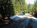
Beverly Creek Road started out bare but had on and off snow on it. Two enterprising
SUVs made it to within about half a mile of the Beverly-Bean Creek trailhead.
The actual parking lot is mostly snow free. Snow starts again just across
the footbridge and is on and off to Bean Creek.
We left the car at 9:00 and I hoped that the creek would be low enough to cross without fording. In fact it was. Using poles we both hopped rocks and walked on skinny logs to cross. On warmer days I expect it to be quite a bit higher. I was most surprised to see foot prints and ski tracks heading up the Beverly "trail". From shortly after Bean Creek there were only a few short bare spots. The rest of the way was on snow with no trail visible. I seldom see others this early along Beverly Creek. The section after the creek was in the trees and the snow was very hard. There was no post holing but traction was minimal. Several times I considered putting on snowshoes just for the traction. While hiking through the trees we met a single woman who had hiked up alone the day before and camped on the snow in the basin. She was the only person we saw all day. The morning was sunny but as we left the forest and entered the lower basin clouds began to appear. This was not all bad as I was sweating up a storm. Rather than take the route of the Summer trail higher on the right side of the valley, I have found that it's easier to stay near the creek. With all the rocks and underbrush buried under many feet of snow the travel was easy.
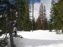
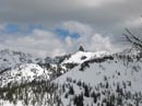
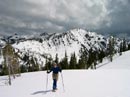
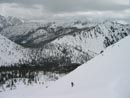
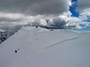
Well before the Summer trail crossed the creek in the upper basin we found a snow bridge to cross on. The creek was a fair distance below the bridge and it sloped down in the center but it looked fairly thick. After poking it with my pole I was comfortable enough to try my weight. It held and we were across the creek. From here it is steep and steeper. The first 5 miles gained about 2100' The last 1 mile gained another 1500'. Just after crossing the creek we heard two other hikers talking. They were heading out. We never did see them. On the last climb Bill and Teanaway Peaks loomed above us. As we worked our way higher we saw Little Annapurna, Volcanic Neck, Bean Peak, Earl Peak, and finally Mt. Stuart. At first we could see the ridge top but as we climbed it went out of sight. I headed for where I expected to find our ridge top target but I was a little too far to the left. Much of the ridge is heavily corniced. It is important to approach the ridge in one of the few safe places. To get there we had to make a rising rightward traverse on a very steep slope. Fortunately the snow conditions were very good. It was soft enough to get good traction but hard enough to keep us from sliding down. The last 500' seemed to take forever as we slogged up the slope. While it is steep there are only a few rocks showing through and a fairly flat run out at the bottom. I was OK with poles and Gary was more comfortable with his ice axe. We finally reached the ridge top right where I hoped, only a few hundred nearly level feet from the summit.
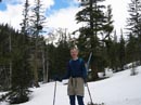
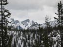
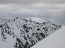
We were very happy to find no wind on top. Even a few hundred feet below the summit it was a bit windy. Over by the Enchantments it was raining hard. The top of Stuart was also in the clouds. To the northwest, Mt. Daniel and Cathedral Rock were in sunshine. It was 1:00 by the time we summited and we were starved. I ate lunch and continued to take photos. The weather was changing by the minute all around us. The view from the top of Iron at 6510' is spectacular in the Spring. From the Teanaway Peaks, to Stuart, Daniel, Rainier, and the peaks of the Cascade crest. This day Rainier was lost in the clouds and so were many of the peaks along the crest. Still, many peaks were visible with a healthy coating of Winter snow. Without any wind and with the rain all around but not on us we spent nearly an hour on top. At about 2:00 we packed up and headed down.
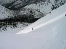
After retracing our steps back along the ridge to where we came up it was time to get ready for a terrific glissade. On went the rain pants and rain jacket and snowshoes were packed away. The first glissade is about 500' vertical feet. It took me about 20 seconds to make it all the way down. Thirty minutes up and 20 seconds down. So much ice flew into my face that I was nearly blind going down. The hard snow allowed me to get up a lot of speed. The first glissade of the season is always the most exciting. Gary soon was right down with me. There were a couple of nice but much smaller glissades to come. After those our snowshoes went back on and we had a nice hike back to the creek. I could not find the summit register as it was under too much snow. There were no signs of human travel from the creek up so it's likely we were the first to summit this year. From the high side of the creek we were able to jump all the way across the snow bridge. After crossing it was just another 5 mile slog back to the car. The weather varied from sun to deep over cast but we stayed dry all the way back. This is easily one of my favorite hikes. This trip reminded my again of why I like it so much.
Click on thumbnails to get larger photos.
Photo Page 2
Home
We left the car at 9:00 and I hoped that the creek would be low enough to cross without fording. In fact it was. Using poles we both hopped rocks and walked on skinny logs to cross. On warmer days I expect it to be quite a bit higher. I was most surprised to see foot prints and ski tracks heading up the Beverly "trail". From shortly after Bean Creek there were only a few short bare spots. The rest of the way was on snow with no trail visible. I seldom see others this early along Beverly Creek. The section after the creek was in the trees and the snow was very hard. There was no post holing but traction was minimal. Several times I considered putting on snowshoes just for the traction. While hiking through the trees we met a single woman who had hiked up alone the day before and camped on the snow in the basin. She was the only person we saw all day. The morning was sunny but as we left the forest and entered the lower basin clouds began to appear. This was not all bad as I was sweating up a storm. Rather than take the route of the Summer trail higher on the right side of the valley, I have found that it's easier to stay near the creek. With all the rocks and underbrush buried under many feet of snow the travel was easy.
Well before the Summer trail crossed the creek in the upper basin we found a snow bridge to cross on. The creek was a fair distance below the bridge and it sloped down in the center but it looked fairly thick. After poking it with my pole I was comfortable enough to try my weight. It held and we were across the creek. From here it is steep and steeper. The first 5 miles gained about 2100' The last 1 mile gained another 1500'. Just after crossing the creek we heard two other hikers talking. They were heading out. We never did see them. On the last climb Bill and Teanaway Peaks loomed above us. As we worked our way higher we saw Little Annapurna, Volcanic Neck, Bean Peak, Earl Peak, and finally Mt. Stuart. At first we could see the ridge top but as we climbed it went out of sight. I headed for where I expected to find our ridge top target but I was a little too far to the left. Much of the ridge is heavily corniced. It is important to approach the ridge in one of the few safe places. To get there we had to make a rising rightward traverse on a very steep slope. Fortunately the snow conditions were very good. It was soft enough to get good traction but hard enough to keep us from sliding down. The last 500' seemed to take forever as we slogged up the slope. While it is steep there are only a few rocks showing through and a fairly flat run out at the bottom. I was OK with poles and Gary was more comfortable with his ice axe. We finally reached the ridge top right where I hoped, only a few hundred nearly level feet from the summit.
We were very happy to find no wind on top. Even a few hundred feet below the summit it was a bit windy. Over by the Enchantments it was raining hard. The top of Stuart was also in the clouds. To the northwest, Mt. Daniel and Cathedral Rock were in sunshine. It was 1:00 by the time we summited and we were starved. I ate lunch and continued to take photos. The weather was changing by the minute all around us. The view from the top of Iron at 6510' is spectacular in the Spring. From the Teanaway Peaks, to Stuart, Daniel, Rainier, and the peaks of the Cascade crest. This day Rainier was lost in the clouds and so were many of the peaks along the crest. Still, many peaks were visible with a healthy coating of Winter snow. Without any wind and with the rain all around but not on us we spent nearly an hour on top. At about 2:00 we packed up and headed down.
After retracing our steps back along the ridge to where we came up it was time to get ready for a terrific glissade. On went the rain pants and rain jacket and snowshoes were packed away. The first glissade is about 500' vertical feet. It took me about 20 seconds to make it all the way down. Thirty minutes up and 20 seconds down. So much ice flew into my face that I was nearly blind going down. The hard snow allowed me to get up a lot of speed. The first glissade of the season is always the most exciting. Gary soon was right down with me. There were a couple of nice but much smaller glissades to come. After those our snowshoes went back on and we had a nice hike back to the creek. I could not find the summit register as it was under too much snow. There were no signs of human travel from the creek up so it's likely we were the first to summit this year. From the high side of the creek we were able to jump all the way across the snow bridge. After crossing it was just another 5 mile slog back to the car. The weather varied from sun to deep over cast but we stayed dry all the way back. This is easily one of my favorite hikes. This trip reminded my again of why I like it so much.
Parking Spot |
Gary & Bill Peak |
Food Break |
Little Annapurna |
Volcanic Neck |
Above The Trees |
Final Climb |
Ridge View |
Iron Peak Summit |
Earl In The Sun |
Photo Page 2
Home