6-28-03
Mt. Jupiter is a hike I have planned
several times in the past. Each time the weather turned poor and I ended
up going far to the east. I tried one more time and the weather was great.
If anything it was too hot. It was clear and the views were spectacular.
Gary was free and joined me. We met in Federal Way and it was almost exactly
2 hours from there to the trailhead. The Mt. Jupiter road is .9 miles north
of the Duckabush River. There are multiple spur roads but all the major
ones had signs. There are no trees to impair ones view from the trailhead.
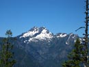
Hood Canal is just below. The Brothers can also be seen from there. We
were on the trail at 9:00 am. 15 people in several groups left just ahead
of us. So much for solitude... The trail begins by switchbacking up to near
the top of the ridge. In this first section we managed to pass all 15 hikers.
It was warm when we started and only became warmer as the day went on.
After gained about 900' the trail flattened. In fact we netted only about
another 600' in the next 3+ miles. There were several ups and downs. The
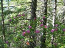
largest lost 200'. The first 5 miles are mostly in forest. There are a
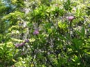
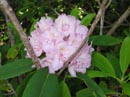
few viewpoints to the south. Rhododendrons go much higher up the mountain
than I was expecting. At the trailhead and for several hundred feet above
the rhrody flowers are finished. Higher up they are very much still in
bloom. We continued to see them until well above 4000'.
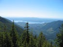
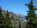
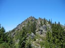
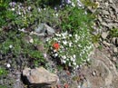
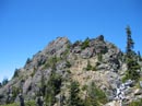
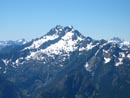
Since the middle of the trail is so flat it goes very quickly. A little before the 5 mile mark there is a viewpoint just off the trail. The Duckabush Valley is below, The Brothers are high above, and Hood Canal is to the east. There is a huge waterfall just below The Brothers that is most spectacular. A few minutes later we reached the wilderness boundary. The first 5 miles took us 2 hours. With only 2 miles left it looked like lunch at noon on top. It was getting very hot now. The trail left the dense forest and became more and more in the open. There were flowers in the forest but they really exploded higher up. In addition to the rhododendrons we saw paintbrush, columbine, phlox, heather, penstemon, and many more. By the time we had reached about 6 miles we were scratching our heads. We were only about a mile from the summit but we were reading about 1200' to go. Finally the trail ended the long traverse and began to switchback up the slope. At this point a hiker passed us coming down. The heat was really getting to me and I slowed considerably. Gary wanted to sprint to the summit so I gave him the OK to take off. The upper section of trail is one of the best I have hiked. The views of the Olympics and the Cascades get better and better. The trail is airy without having any really exposed spots. A few sections were blasted out of the hillside. When the trail first reached the ridge top views opened to the north. All five Washington volcanoes were visible. It was so clear that there was not a single cloud in the sky. Even at my glacially slow pace I managed to pass one hiker. I finally reached the summit about 15 minutes after Gary. He had done Jupiter back in 1986 but on a cloudy day with no views.
The location of Jupiter gives it much better views than it's 5701' elevation would suggest. It is very close to Hood Canal with no other peaks near by. The Duckanbush River on the south and the Dosewallips on the north carve deep valleys on both sides. We could peaks in British Columbia and Mt. St. Helens down near Oregon. Seattle is just east and downtown is very clear. The Olympic peaks are visible from Washington in the south to Mt. Townsend in the north. The Brothers and Mt. Constance seem the largest. I think I recognized Mt. Anderson as well. After lunch the masses arrived. The summit is large enough for 20 people but it was a little too loud for us. We hiked around the north side of the summit to a point where we could see Jupiter Lakes. One is mostly clear and another is snow covered. The north side of the peak still has a fair amount of snow. There was not a drop on the trail. We found a secluded spot in the shade of a large rock and relaxed. On of the best parts of the hike was the long summit stay. We spent nearly 3 hours on top.
At 3:00 we packed up and headed down. In the first 1/2 mile we passed several groups still coming up. They were going very slow in the heat of the day. The trip down was long and uneventful. After the first 2+ miles we reentered forest and it cooled down immensely. We stopped at several viewpoints and had a liesurely hike down. The 100 hikes guide lists this trip at 14 miles and 3600' gained. Don't believe it. It is about 14 1/2 and 4400' with ups and downs. It was a brutally hot day but it was worth it to have such clear views. This is a great trip for strong hikers.
Click on thumbnails to get larger pictures.
Photo Page 2
Home
Since the middle of the trail is so flat it goes very quickly. A little before the 5 mile mark there is a viewpoint just off the trail. The Duckabush Valley is below, The Brothers are high above, and Hood Canal is to the east. There is a huge waterfall just below The Brothers that is most spectacular. A few minutes later we reached the wilderness boundary. The first 5 miles took us 2 hours. With only 2 miles left it looked like lunch at noon on top. It was getting very hot now. The trail left the dense forest and became more and more in the open. There were flowers in the forest but they really exploded higher up. In addition to the rhododendrons we saw paintbrush, columbine, phlox, heather, penstemon, and many more. By the time we had reached about 6 miles we were scratching our heads. We were only about a mile from the summit but we were reading about 1200' to go. Finally the trail ended the long traverse and began to switchback up the slope. At this point a hiker passed us coming down. The heat was really getting to me and I slowed considerably. Gary wanted to sprint to the summit so I gave him the OK to take off. The upper section of trail is one of the best I have hiked. The views of the Olympics and the Cascades get better and better. The trail is airy without having any really exposed spots. A few sections were blasted out of the hillside. When the trail first reached the ridge top views opened to the north. All five Washington volcanoes were visible. It was so clear that there was not a single cloud in the sky. Even at my glacially slow pace I managed to pass one hiker. I finally reached the summit about 15 minutes after Gary. He had done Jupiter back in 1986 but on a cloudy day with no views.
The location of Jupiter gives it much better views than it's 5701' elevation would suggest. It is very close to Hood Canal with no other peaks near by. The Duckanbush River on the south and the Dosewallips on the north carve deep valleys on both sides. We could peaks in British Columbia and Mt. St. Helens down near Oregon. Seattle is just east and downtown is very clear. The Olympic peaks are visible from Washington in the south to Mt. Townsend in the north. The Brothers and Mt. Constance seem the largest. I think I recognized Mt. Anderson as well. After lunch the masses arrived. The summit is large enough for 20 people but it was a little too loud for us. We hiked around the north side of the summit to a point where we could see Jupiter Lakes. One is mostly clear and another is snow covered. The north side of the peak still has a fair amount of snow. There was not a drop on the trail. We found a secluded spot in the shade of a large rock and relaxed. On of the best parts of the hike was the long summit stay. We spent nearly 3 hours on top.
At 3:00 we packed up and headed down. In the first 1/2 mile we passed several groups still coming up. They were going very slow in the heat of the day. The trip down was long and uneventful. After the first 2+ miles we reentered forest and it cooled down immensely. We stopped at several viewpoints and had a liesurely hike down. The 100 hikes guide lists this trip at 14 miles and 3600' gained. Don't believe it. It is about 14 1/2 and 4400' with ups and downs. It was a brutally hot day but it was worth it to have such clear views. This is a great trip for strong hikers.
Rhrododendron |
Rhody Blooms |
Tall Bushes |
The Brothers |
Hood Canal |
Mt. Constance |
Near Summit View |
Rock Garden |
Near Summit |
The Brothers |
Photo Page 2
Home