5-03-03
With a forecast of rain and cold
in the mountains I decided to head way east to try to get in a nice day
of hiking. The Red Hill Spur trail leaves from the Devil's Gulch - Mission
Ridge trailhead just north of Cashmere and east of Leavenworth. I have
done both Devil's Gulch and Mission Ridge but not the Red Hill Spur. There
is another way to get to Red Hill from a near by trailhead. I chose this
one so I could have the option of a hike part way up Devil's Gulch as well.
It is 138 miles from north Seattle to the trail head. It took me just under
3 hours with minimal traffic on Highway 2. With the long drive it was already
10:20 when I got started. Two people were just finishing a hike when I started.
They were 2/3 of the people I saw this day. It was mostly overcast but shorts
and short sleeves warm. Only a few minutes up the trail I came to an intersection
with the Red Devil trail. I don't remember this from previous trips so
it may be a fairly new trail. Maybe not that new as it had been 11 years
since I last hiked here. Just after that the trail to Mission Ridge crosses
a bridge and starts to climb. I stayed on the Devils Gulch trail. Wildflowers
started along the road out of Cashmere and continued at the start of the
trail. I saw half a dozen familiar flowers in the first 1/2 mile whose names
I can't remember. I did see quite a lot of Balsamroot. They were at or just
past their peak. At about 3/4 mile there was an unsigned trail heading off
to the right. I thought that it might be the Red Hill trail but I was sure
it used to be signed. I decided to continue up Devil's Gulch a little further
to see if there was another side trail. The Gulch trail was in good condition.
After another 3/4 mile I was sure I had passed the Red Hill trail and headed
back. The detour up Devil's Gulch was a nice side trip in it's own right.
Back at the unsigned trail I turned and followed it away from the creek. This trail is popular with motorcycles and mountain bikes as well as horses and hikers. It is narrow and in fact much of it traverses steep hillsides where moving off trail for a motorcycle or horse would be a chore. Fortunately I did not have that problem this day. From the dry balsamroot covered slopes near the creek the trail quickly enters deep forest with bright green underbrush. This part is very lush for being so far east. As I gained elevation new varieties of wildflowers appeared. I spooked a deer just off the trail and it ran away before I could take a photograph. One nice feature of hiking alone is the amount of wild life I see. With no talking I often get close to animals before they hear me. A few minutes later I came upon another 3 deer. These deer were kind enough to pose for pictures before running away. This trail was built for motorcycles and as such it is very gently graded. Only a few stretches are even near 10% grade. With such an easy grade it is simple to keep up a good pace. After a few switchbacks the trail comes out into the open. Devil's Gulch is below. Mission Ridge is on the far side of the gulch. Mission Ridge ski area is far in the distance. Still plenty of snow on the highest peaks but none on the trail. My high point was 3400' and I saw no snow on or near the trail all day. I did see glacier lilies in bloom near the high point so the snow must have just recently melted out.
The trail switchbacks to the right and attains a ridge top. The hill side was in the open but once on the ridge I went back into forest. The lower forest was mostly firs but up on the ridge most of the trees were pine. Even in the trees I noticed a marked increase in the wind. It was a cold wind and I soon rolled my sleeves back down. The 100 hikes book describes the other trail up Red Hill and mentions this trail. The other trail is 4 1/2 miles to the top of Red Hill. The book does not mention the mileage via this trail. In the book the hand drawn map seems to show both trails being about the same distance. I searched but could not find my Liberty Quad map the night before. With this in mind I expected the two trails to meet within about 2 1/2 miles or less. At about 4 miles in (plus my 1 1/2 mile detour) I still had not reached the trail intersection. I did reach a high point with views out to the Stuart Range. It was such an unusual angle that at first I didn't recognize Mt. Stuart. Quite a nice view. I stopped to have a little lunch as it was already 12:30. After eating I headed on and down. The trail lost about 180 feet to a saddle then started to climb again. Shortly after that I reached the intersection with the other Red Hill trail. If the book was correct it would still be another 3 miles to Red Hill. I decided to keep going but I didn't plan on going all the way to Red Hill. I climbed to one more high point at 3600' just 200' lower than Red Hill. The trail descended again and the skies were definitely getting darker. Add in a very cold wind and I decided it was time to head for home. By now I had gloves on. Several other wildflowers appeared near the high point. Glacier Lilies were right at their peak. I followed the trail back to a meadow just before leaving the ridge top and stopped to finish my lunch. Partial views form here were back towards Cashmere.
Just before leaving the ridge a motorcycle went by. He was the only person I saw on the trail all day. After dropping off the ridge I moved out of the wind. At lower elevations it actually began to feel warm again. The rest of the way back was easy with numerous stops to take photos of the flowers. By 3:15 I was back at my car. Most of my hikes are to a destination. It is usually a lake or a mountain top. This trip was different. I never reached Red Hill even though I traveled about 12 miles. On this hike the trail was the reason to do the hike. It started warm along a creek. It had desert like sections. It had dark and green forest. It had a long ridge walk with some nice views. The trail itself was the highlight of this trip. The trail and the wildflowers. This would be totally different when the wildflowers are through and the motorcycles are running fast and furious. But for a quiet Spring day this was a great trip.
Click on thumbnails to get larger pictures.
Photo Page 2
Home
Back at the unsigned trail I turned and followed it away from the creek. This trail is popular with motorcycles and mountain bikes as well as horses and hikers. It is narrow and in fact much of it traverses steep hillsides where moving off trail for a motorcycle or horse would be a chore. Fortunately I did not have that problem this day. From the dry balsamroot covered slopes near the creek the trail quickly enters deep forest with bright green underbrush. This part is very lush for being so far east. As I gained elevation new varieties of wildflowers appeared. I spooked a deer just off the trail and it ran away before I could take a photograph. One nice feature of hiking alone is the amount of wild life I see. With no talking I often get close to animals before they hear me. A few minutes later I came upon another 3 deer. These deer were kind enough to pose for pictures before running away. This trail was built for motorcycles and as such it is very gently graded. Only a few stretches are even near 10% grade. With such an easy grade it is simple to keep up a good pace. After a few switchbacks the trail comes out into the open. Devil's Gulch is below. Mission Ridge is on the far side of the gulch. Mission Ridge ski area is far in the distance. Still plenty of snow on the highest peaks but none on the trail. My high point was 3400' and I saw no snow on or near the trail all day. I did see glacier lilies in bloom near the high point so the snow must have just recently melted out.
The trail switchbacks to the right and attains a ridge top. The hill side was in the open but once on the ridge I went back into forest. The lower forest was mostly firs but up on the ridge most of the trees were pine. Even in the trees I noticed a marked increase in the wind. It was a cold wind and I soon rolled my sleeves back down. The 100 hikes book describes the other trail up Red Hill and mentions this trail. The other trail is 4 1/2 miles to the top of Red Hill. The book does not mention the mileage via this trail. In the book the hand drawn map seems to show both trails being about the same distance. I searched but could not find my Liberty Quad map the night before. With this in mind I expected the two trails to meet within about 2 1/2 miles or less. At about 4 miles in (plus my 1 1/2 mile detour) I still had not reached the trail intersection. I did reach a high point with views out to the Stuart Range. It was such an unusual angle that at first I didn't recognize Mt. Stuart. Quite a nice view. I stopped to have a little lunch as it was already 12:30. After eating I headed on and down. The trail lost about 180 feet to a saddle then started to climb again. Shortly after that I reached the intersection with the other Red Hill trail. If the book was correct it would still be another 3 miles to Red Hill. I decided to keep going but I didn't plan on going all the way to Red Hill. I climbed to one more high point at 3600' just 200' lower than Red Hill. The trail descended again and the skies were definitely getting darker. Add in a very cold wind and I decided it was time to head for home. By now I had gloves on. Several other wildflowers appeared near the high point. Glacier Lilies were right at their peak. I followed the trail back to a meadow just before leaving the ridge top and stopped to finish my lunch. Partial views form here were back towards Cashmere.
Just before leaving the ridge a motorcycle went by. He was the only person I saw on the trail all day. After dropping off the ridge I moved out of the wind. At lower elevations it actually began to feel warm again. The rest of the way back was easy with numerous stops to take photos of the flowers. By 3:15 I was back at my car. Most of my hikes are to a destination. It is usually a lake or a mountain top. This trip was different. I never reached Red Hill even though I traveled about 12 miles. On this hike the trail was the reason to do the hike. It started warm along a creek. It had desert like sections. It had dark and green forest. It had a long ridge walk with some nice views. The trail itself was the highlight of this trip. The trail and the wildflowers. This would be totally different when the wildflowers are through and the motorcycles are running fast and furious. But for a quiet Spring day this was a great trip.
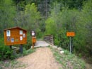
Trailhead |
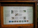
Bird Info |
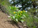
Balsamroot |
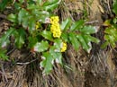
Oregon Grape |
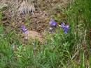
Blue Flower |
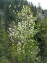
Serviceberry |
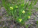
Western Gromwell |
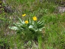
Balsamroot |
Photo Page 2
Home