02-02-03
This is a trip I had read a number of reports on and
had been meaning to try. Since it is a long road walk I didn't want to give
up a sunny Summer day. With this low snow Winter the second day of February
was perfect. The morning Doppler radar showed not a drop of rain anywhere
near North Bend so I was hoping for a dry day. It was nice in Seattle but
as soon as I headed east of Issaquah the rain started. Amazingly, it actually
stopped as I drove up the Middle Fork Road. As mentioned in earlier reports,
the gated road/trail is 5 miles beyond the end of pavement and about 1 1/2
miles beyond the bridge over the river. I started at about 9:15. The trailhead
is at 931'. There were no other cars. This is one of the nicest roads I
have hiked. It is mostly smooth with almost no water damage. At 1.1 miles
I reached the CCC road. The road is bisected by a creek to the left. The
only previous time I was at this spot was on the other side of the creek
in my car about 20 years ago. I suspect the other end of the CCC road is
also now gated.
The first section was very easy, gaining only 400'. At the creek I turned right and proceeded on the CCC road. finding the turn uphill on the Bessemer Road is not a problem. The uphill road is in much better shape than the CCC where it continues. The road slowly begins to steepen. In fact, I think each mile is a little steeper than the one before. The road makes numerous switchbacks and a creek is crossed 3 times. The first 2 crossings are rock hops and the last one goes under the road. The water was high this day but I had no trouble getting across with dry feet. The high water did give me some nice cascades photos though. The lower road goes through a nice thick forest. Up above there are view out but I had none at all through the clouds. After the first couple of miles I was in the clouds completely. I will have to do the trip on a clear day to see just what I missed. After the last creek crossing I passed a strange piece of equipment. It was tall and very short. I would guess it has some logging use. Small trees are growing up all around it so I bet it's been sitting there for awhile. The wheels seemed to be inflated so it could not have been too long.
At about 4 1/3 miles a road goes straight ahead and the main road goes more steeply uphill, switchbacking to the right. A little farther at about 3500' were the first snow patches. Soon the road was covered with about 2 inches of fresh snow. At about 4000' is a junction with two major roads going uphill left and right. I was carrying a good sized pack with snowshoes, lots of clothing, and 9 of the essentials. A quick look showed that I had left my map at home. With no prints at all in the snow I figured my chances of reaching the summit were not very good. I took the left road and very quickly reached a saddle at 4100'. The ridge was heavily timbered except for the completely clearcut saddle and steep roads going up the ridge on both sides. With visibility of about 100' I had no idea where the summit was. With no views and already having gained 3200' in a little over 5 miles, I would not have been disappointed to miss the summit. It was only 11:30 at that point so I decided to head higher and hope for the best. I went right and slogged through deepening snow. The road went up the left side of the ridge and quickly fell well below it. The road began to get poorer then reached a high point. It dropped quickly down from there. From the saddle it is another 950' to the top and I knew going steeply down wasn't going to get me there. I started backtracking when I saw a small spur partly hidden by a bent over tree. I had completely missed it going up. I headed up the spur. The snow was now too deep so I stopped to put on my snowshoes. This spur switched back and began to point towards the ridge. It crossed the ridge and continued around the mountain, now at a very gentle grade. The road became narrower and seemed to be going nowhere. I thought it was about time to give up when the road suddenly reached a much better road. The new road climbed to my left and descended to the right. I am almost sure that this must be the road I didn't take just before climbing to the saddle. Next time I will try that other road and see.
Now on a better road and climbing again I was getting more confident about actually reaching the top. The road headed back to the ridge then switched back to the right. A few more short switchbacks and I could vaguely see the top through the haze. There are actually two summits close to each other. The lower one is rocks almost entirely covered with snow. The higher one is completely snow covered and has some trees right on top. Visibility was such that I could barely see one summit from the other. I took 2 1/4 hours to reach the saddle and another full hour to reach the top. Coming down it was only about 25 minutes back to the saddle. Shortly before reaching the summit it began to snow. Back at the saddle it was a near blizzard. Even at 5000' it was not cold. I measured about 32 degrees for the low of the day.
Coming down was a long slog but the road was so nice I didn't mind. This is much easier on the knees than the Teneriffe Road. Just as I reached that strange logging equipment I met three motorcycles. The snow soon stopped them and they passed my again coming down. They were the only people I saw all day. The snow turned to rain and the intensity varied but it never stopped. By the time I reached the bottom I was wet but still quite warm. This hike will be one I will do on a regular basis. It is long with lots of elevation gain on a road but one I really enjoyed. Now I will have to return to see just how good the views are. I estimate the distance at about 13 miles with 4300' of elevation gain. I took 3:17 up and 2:23 down.
Click on thumbnail to get larger picture.
Photo Page 2
Home
The first section was very easy, gaining only 400'. At the creek I turned right and proceeded on the CCC road. finding the turn uphill on the Bessemer Road is not a problem. The uphill road is in much better shape than the CCC where it continues. The road slowly begins to steepen. In fact, I think each mile is a little steeper than the one before. The road makes numerous switchbacks and a creek is crossed 3 times. The first 2 crossings are rock hops and the last one goes under the road. The water was high this day but I had no trouble getting across with dry feet. The high water did give me some nice cascades photos though. The lower road goes through a nice thick forest. Up above there are view out but I had none at all through the clouds. After the first couple of miles I was in the clouds completely. I will have to do the trip on a clear day to see just what I missed. After the last creek crossing I passed a strange piece of equipment. It was tall and very short. I would guess it has some logging use. Small trees are growing up all around it so I bet it's been sitting there for awhile. The wheels seemed to be inflated so it could not have been too long.
At about 4 1/3 miles a road goes straight ahead and the main road goes more steeply uphill, switchbacking to the right. A little farther at about 3500' were the first snow patches. Soon the road was covered with about 2 inches of fresh snow. At about 4000' is a junction with two major roads going uphill left and right. I was carrying a good sized pack with snowshoes, lots of clothing, and 9 of the essentials. A quick look showed that I had left my map at home. With no prints at all in the snow I figured my chances of reaching the summit were not very good. I took the left road and very quickly reached a saddle at 4100'. The ridge was heavily timbered except for the completely clearcut saddle and steep roads going up the ridge on both sides. With visibility of about 100' I had no idea where the summit was. With no views and already having gained 3200' in a little over 5 miles, I would not have been disappointed to miss the summit. It was only 11:30 at that point so I decided to head higher and hope for the best. I went right and slogged through deepening snow. The road went up the left side of the ridge and quickly fell well below it. The road began to get poorer then reached a high point. It dropped quickly down from there. From the saddle it is another 950' to the top and I knew going steeply down wasn't going to get me there. I started backtracking when I saw a small spur partly hidden by a bent over tree. I had completely missed it going up. I headed up the spur. The snow was now too deep so I stopped to put on my snowshoes. This spur switched back and began to point towards the ridge. It crossed the ridge and continued around the mountain, now at a very gentle grade. The road became narrower and seemed to be going nowhere. I thought it was about time to give up when the road suddenly reached a much better road. The new road climbed to my left and descended to the right. I am almost sure that this must be the road I didn't take just before climbing to the saddle. Next time I will try that other road and see.
Now on a better road and climbing again I was getting more confident about actually reaching the top. The road headed back to the ridge then switched back to the right. A few more short switchbacks and I could vaguely see the top through the haze. There are actually two summits close to each other. The lower one is rocks almost entirely covered with snow. The higher one is completely snow covered and has some trees right on top. Visibility was such that I could barely see one summit from the other. I took 2 1/4 hours to reach the saddle and another full hour to reach the top. Coming down it was only about 25 minutes back to the saddle. Shortly before reaching the summit it began to snow. Back at the saddle it was a near blizzard. Even at 5000' it was not cold. I measured about 32 degrees for the low of the day.
Coming down was a long slog but the road was so nice I didn't mind. This is much easier on the knees than the Teneriffe Road. Just as I reached that strange logging equipment I met three motorcycles. The snow soon stopped them and they passed my again coming down. They were the only people I saw all day. The snow turned to rain and the intensity varied but it never stopped. By the time I reached the bottom I was wet but still quite warm. This hike will be one I will do on a regular basis. It is long with lots of elevation gain on a road but one I really enjoyed. Now I will have to return to see just how good the views are. I estimate the distance at about 13 miles with 4300' of elevation gain. I took 3:17 up and 2:23 down.
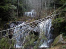
Waterfall |
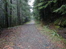
Road In Forest |
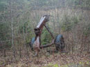
Equipment |
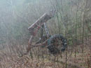
Equipment Again |
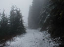
A Little Snow |
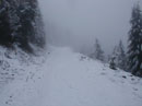
Deeper Snow |

Nearing The Top |
Photo Page 2
Home