8-23-03
Three Brothers is one of my favorite
scrambles. I have done it via three different routes. The one I most enjoy
is the long trail version on the Stafford Creek Trail to Navaho Pass then
the County Line Trail over to the final ridge scramble. This is a long
trip as it covers 17 miles. The final ridge scramble is about 8/10 ths
of a mile gaining 1200'. This is not a technically difficult scramble though
the final ridge does require care. It is just a long and very enjoyable
day. It is just too hot in the Teanaway in mid summer for such a long trip
so I waited for a cooler day. With Snoqualmie forecast to be cloudy and
63 degrees. I headed east. I arrived at the Stafford Creek trailhead just
before 8:00 am and I was on the trail within about 10 minutes. Only one
other vehicle was in the lot. The trail is never steep as it gains 3000'
over 6 miles to Navaho Pass. With the cool morning I zoomed up the trail.
This has been a very dry summer but most of the creeks along the trail are
still flowing. I was last on the trail at the end of May to climb Navaho
Peak. The lower elevation flowers are nearly all gone now. I was surprised
to see some flowers above 5000'. The trail is very dusty as it gets significant
horse traffic. Since I was alone this was not a problem. In fact there was
virtually nobody to kick up dust. More on that later. After only 2:04 I arrived
at Navaho Pass, 6000' and 6 miles from the start. This was the easy part.
A stiff wind was blowing at the pass and I feared that the summit of Three
Brothers might be much worse.
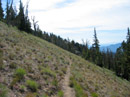
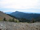
After my first break for food and water I was off on the County Line Trail heading east. The trail gets very little maintenance and very few visitors. It has loose sandy dirt part of the way as it quickly gains altitude. Soon Mt. Stuart coming into view. This is a good angle as you can see the slope better than straight from the south. The County Line reaches the ridge top at a completely bare section. Nothing grows here. This is where the scramble trail to the top of Navaho leaves the County Line Trail and follows the ridge to the top. The County Line now contours around Navaho at more or less a level grade. Much of the way is out in the open. The trail goes from good to very sketchy. While there is very little trail in places it is not that hard to follow. The route finally reaches the eastern ridge of Navaho. This is where you get the first view of Three Brothers. Beyond here the ridge drops steeply and climbs to Little Navaho. The County Line drops steeply over the north side of the ridge and drops down to a meadow. There is a small spring fed creek here and green grass and flowers. The route continues to descend at a more moderate grade to the pass between the Falls Creek Trail and the Negro Creek Trail. The trail is very sketchy and disappears all together for a time in a grassy meadow but by staying on top of the ridge it is easily found again. The low point of the ridge is a saddle where three trails meet and a fourth route starts. To the left is the Falls Creek Trail down to Ingalls Creek. To the right is the start of the Negro Creek Trail. Straight ahead and up the ridge is the route to the eastern Three Brothers summit. There are also middle and western summits. The western one has a trail to the top and remnants of the old fire lookout. A big cast iron stove remains. That summit is a little more than a day trip.
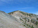
The scrambling fun begins from the pass. There is somewhat of a boot beaten path all the way to the top. On one occasion I managed to follow it all the way. On all my other trips I have been off of it more than on. The only key is to stay near the ridge and not to get on the left side of it. I did that my first time up and found some nasty cliffs. There are small trees which form an impenetrable wall in places. There is lots of loose sandy gravel. There is even a little rock scrambling. With some scrambling experience it is not a hard climb. What's hard is to climb 1200' in less than a mile after over 7 1/2 miles of hiking. I reached the top right about noon and just in time for lunch. There were some clouds but still a fair bit of sun. To the west it was solid clouds but they were high and the crest peaks were clear. From 7300' this far east the view to the east is well into eastern Washington. Mt. Stuart has just a little snow near the top. One small patch has endured below the summit of Earl Peak. Everything else nearby is brown. When I first came up there were two summit registers. One from the Mountaineers and one from another group. I believe it was the Cascadians. The Cascadian register went back to 1960. There is still a second tube but it no longer has a register inside. This has been the busiest year I have seen. I was the 9th party to sign in. Unfortunately, the register was replaced in 2002 so I could not look back on previous years. The wind was not as bad as I feared. It was icy cold though. It was out of the north and I was able to drop just below the summit to avoid it. I spent 1:40 on top enjoying the view.
At 1:45 I started down. I managed to completely lose the route and ended up down climbing a few steeper places than should have been necessary. Still, it was an enjoyable climb down. In just over 30 minutes I was back down to the pass. Now the sun was out of the clouds and it was getting warmer. Still nothing like it usually is here in August. The last significant climb is back to the ridge coming off Navaho. In short order this was accomplished and I had my last look back to Three Brothers. If a person had reserves of energy you could head over to Little Navaho. Another option would be to follow the ridge up to Navaho then come down the usual route to Navaho Pass. Since I didn't have that energy I continued on the County Line back around Navaho Peak. I dropped back down to Navaho Pass and found nobody. The only new footprints where the Stafford Creek trail hits the pass were mine. A Saturday in August and nobody else had come up to the pass. After a break I was about to head down when a solo backpacker came into view nearing the pass. I waited for his arrival. As it turned out Don lives less than a mile from me in Seattle. He has the truck I saw in the morning. He verified that he and I had the only vehicles in the lot and nobody had passed him. I hope he had a good time camping at the pass. By the time I finally got going it was about 3:50. The trip down was fun. The temperature was perfect and the trail was empty. About 2 miles from the car I met a second party. This couple wondered if they were "almost there". Unfortunately they didn't know what "there" was. The bad news is that they were 4 miles from the pass with less than 3 hours of daylight left. I hope they had the sense not to go to the pass or they would have had a long dark trip down. At 6:00 I made it out. After 10 hours, 17 miles, and 5100' of gain I was dog tired. It was another memorable journey to Three Brothers.
Click on thumbnails to get larger pictures.
Photo Page 2
After my first break for food and water I was off on the County Line Trail heading east. The trail gets very little maintenance and very few visitors. It has loose sandy dirt part of the way as it quickly gains altitude. Soon Mt. Stuart coming into view. This is a good angle as you can see the slope better than straight from the south. The County Line reaches the ridge top at a completely bare section. Nothing grows here. This is where the scramble trail to the top of Navaho leaves the County Line Trail and follows the ridge to the top. The County Line now contours around Navaho at more or less a level grade. Much of the way is out in the open. The trail goes from good to very sketchy. While there is very little trail in places it is not that hard to follow. The route finally reaches the eastern ridge of Navaho. This is where you get the first view of Three Brothers. Beyond here the ridge drops steeply and climbs to Little Navaho. The County Line drops steeply over the north side of the ridge and drops down to a meadow. There is a small spring fed creek here and green grass and flowers. The route continues to descend at a more moderate grade to the pass between the Falls Creek Trail and the Negro Creek Trail. The trail is very sketchy and disappears all together for a time in a grassy meadow but by staying on top of the ridge it is easily found again. The low point of the ridge is a saddle where three trails meet and a fourth route starts. To the left is the Falls Creek Trail down to Ingalls Creek. To the right is the start of the Negro Creek Trail. Straight ahead and up the ridge is the route to the eastern Three Brothers summit. There are also middle and western summits. The western one has a trail to the top and remnants of the old fire lookout. A big cast iron stove remains. That summit is a little more than a day trip.
The scrambling fun begins from the pass. There is somewhat of a boot beaten path all the way to the top. On one occasion I managed to follow it all the way. On all my other trips I have been off of it more than on. The only key is to stay near the ridge and not to get on the left side of it. I did that my first time up and found some nasty cliffs. There are small trees which form an impenetrable wall in places. There is lots of loose sandy gravel. There is even a little rock scrambling. With some scrambling experience it is not a hard climb. What's hard is to climb 1200' in less than a mile after over 7 1/2 miles of hiking. I reached the top right about noon and just in time for lunch. There were some clouds but still a fair bit of sun. To the west it was solid clouds but they were high and the crest peaks were clear. From 7300' this far east the view to the east is well into eastern Washington. Mt. Stuart has just a little snow near the top. One small patch has endured below the summit of Earl Peak. Everything else nearby is brown. When I first came up there were two summit registers. One from the Mountaineers and one from another group. I believe it was the Cascadians. The Cascadian register went back to 1960. There is still a second tube but it no longer has a register inside. This has been the busiest year I have seen. I was the 9th party to sign in. Unfortunately, the register was replaced in 2002 so I could not look back on previous years. The wind was not as bad as I feared. It was icy cold though. It was out of the north and I was able to drop just below the summit to avoid it. I spent 1:40 on top enjoying the view.
At 1:45 I started down. I managed to completely lose the route and ended up down climbing a few steeper places than should have been necessary. Still, it was an enjoyable climb down. In just over 30 minutes I was back down to the pass. Now the sun was out of the clouds and it was getting warmer. Still nothing like it usually is here in August. The last significant climb is back to the ridge coming off Navaho. In short order this was accomplished and I had my last look back to Three Brothers. If a person had reserves of energy you could head over to Little Navaho. Another option would be to follow the ridge up to Navaho then come down the usual route to Navaho Pass. Since I didn't have that energy I continued on the County Line back around Navaho Peak. I dropped back down to Navaho Pass and found nobody. The only new footprints where the Stafford Creek trail hits the pass were mine. A Saturday in August and nobody else had come up to the pass. After a break I was about to head down when a solo backpacker came into view nearing the pass. I waited for his arrival. As it turned out Don lives less than a mile from me in Seattle. He has the truck I saw in the morning. He verified that he and I had the only vehicles in the lot and nobody had passed him. I hope he had a good time camping at the pass. By the time I finally got going it was about 3:50. The trip down was fun. The temperature was perfect and the trail was empty. About 2 miles from the car I met a second party. This couple wondered if they were "almost there". Unfortunately they didn't know what "there" was. The bad news is that they were 4 miles from the pass with less than 3 hours of daylight left. I hope they had the sense not to go to the pass or they would have had a long dark trip down. At 6:00 I made it out. After 10 hours, 17 miles, and 5100' of gain I was dog tired. It was another memorable journey to Three Brothers.
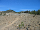
Near Navaho Pass |
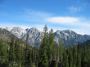
The Stuart Range |
Mt. Stuart |
Mt. Stuart |
County Line Trail |
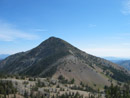
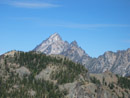
Three Brothers |
Meadows |
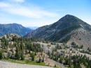
Navaho Peak |
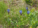
Gentians |
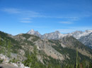
Negro Creek Valley |
Photo Page 2