7-03-04
Neither Gary nor I had hiked up
Icicle Creek in several years. We wanted to do a trail that neither of
us had been on. Our choice ended up being Blackjack Ridge. The weather
was marginal and we hoped this trip would be far enough east to miss any
rain. It was raining at Stevens Pass and the dark clouds continued much of
the way towards Leavenworth. The weather was better there but we still had
a 19 mile drive up the Icicle and back west again. It was very cloudy when
we reached the trailhead but we decided to stick with this hike anyway. The
trail is listed as abandoned and is not on most maps. We were prepared for
the worst and very pleasantly surprised by the reality. The plan was to scramble
up Bootjack Mountain and if time and weather allowed, go for Highchair Mountain
as well. After a 3 hour drive from home we arrived at the trailhead and were
on the trail by 9:30.
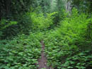
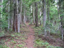
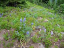
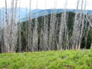
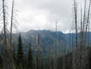
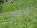
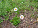
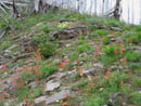
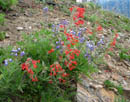
The abandoned trail is in better shape than many maintained trails I have been on. Best of all, it is covered with thick duff. This makes it very easy on the feet. It needs to be because the trail gains 3250' in just 3 miles to where it crosses the ridge and the ridge scramble begins. The trail is so well graded and makes so many short switchbacks that it does not seem like it gains almost 1000' per mile. There were a few logs down across the trail but none proved difficult to go over or around. We climbed higher and higher through the forest until the grade eased and the switchbacks turned to a trail along the ridge. The forest gave way to the silvered remnants of a burned forest with grass and flowers beneath. Lupine and paintbrush were dominant with many other flowers as well. The route continued to gain elevation until it soon reached the top of a ridge. This spot was a blaze of color. Scarlet Gilia grew everywhere here with paintbrush, lupine, and many others. This was a nice place to take a break and photograph all the colors.
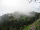
We could see Bootjack Mountain in the clouds at the high point of the ridge we were on. The ridge curves around to the left while steadily gaining elevation. The trail dropped rapidly down the other side of the ridge. We began to ascend the ridge, at first through more silvered trees of the burn. Quickly we picked up a faint boot path though one is really not needed. Many more flowers presented themselves as we slowly worked our way up the ridge while stopping often to take photos. The ridge presented no problems. The last part was rock and steeper but the scramble was very easy. It was about 12:30 when we reached the summit. The clouds were lifting a little but the summits of Stuart, The Cradle, and Cashmere were all in the clouds still. From the summit we could see a lower summit on the ridge. We could also see where the ridge turned to the right for a long knife edge appearing section then run right up to the summit of Highchair Mountain. With Bootjack out of the way, we debated if we still had enough time to reach Highchair, ridge route allowing. At 1:05 we decided to make an attempt of Highchair. Since I had scrambled The Cradle I hoped to get a close up view of it's seldom seen east side from Highchair.
We had not heard any reports of the route from Bootjack to Highchair along the ridge so we did not know if the route would go. That just added to the adventure. Dropping down the south ridge was easy. We went almost over the top of the lower summit and continued on the ridge top. There were some trees and more silvered forest. The route proved to be very reasonable. We dropped off the ridge top in a few places but quickly regained it. After dropping about 600' we reached the knife edge. This section proved to be much easier than we expected. Every difficult spot provided a ledge or a ramp to allow us to continue. We were able to stay on or just below the top all the way across. The way was not difficult but it was not very fast either. Where the ridge goes steeply up a high bump made up of an enormous pile of rock we exited to the left into a heather basin. At 6200' we were about 850' below the summit. This place was an unexpected delight as it contained a tarn and many spring fed creeks meandering through the heather. Pine, fir, and larch trees were interspersed. Of course, the flower show continued with shooting stars now joining in.
Getting back on the ridge would have required climbing up steep talus. A better choice seemed to be to cross the basin to another ridge heading to the false summit south of the actual summit. That ridge looked to be much easier. We continued on with a rising traverse to our left through larch, heather, flowers, and cascading creeks. I did not expect anything like this. We crossed one snow field and were on the ridge about 400' below the summit. The ridge was moderately steep at first but the footing was good and the going was easy. It soon moderated and we topped out on the false summit. From a distance the summit ridge of Highchair appeared to be nearly level. In reality there were a number of spires and the east face dropped off sharply. We dropped a little on the west side and were able to avoid the crud on top. A few ups and downs and we were under the real summit. From there it was an easy talus hike to the top. It was about 3:00 when we summited. In the 2 hours it took us to cross from Bootjack the clouds had lifted dramatically. Cashmere was still mostly in clouds but The Cradle was out along with Stuart from time to time. Sixty Six Hundred Ridge was nearby as was Mt. Harding to the south. Below us on the west was a big meadow with a tarn. Ingalls and South Ingalls plus Fortune were visible. Most of Icicle Ridge was open. Even Three Queens came out of the clouds. All the peaks to the south were showing their north sides, still cloaked in their winter white. The panorama from 7016' was very impressive. This is one of the best viewpoints I have been on. The wind was blowing from the west. The mountain had blocked it until we reached the summit ridge While the wind was cold the sunshine made it bearable. I would have like to spend a few hours on top. Unfortunately, we were already running late. It was 3:30 when we packed up and headed down.
From the top we could clearly see what we were unable to see from the bottom. It is not difficult to head straight down from the summit. In less than 15 minutes we were off of the rock and back in the sloping trees and heather. On top we discussed what would likely be the fastest route back to the trail on the gilia filled ridge. We know that the trail dropping down from the ridge continued through the valley below the mountain. We also knew it was not on our maps and that experienced scramblers had reported losing it numerous times as it disappeared due to lack of use. We already knew the ridge route was slow and now we would have to gain back 650' as well. We decided to attempt to traverse around Bootjack on a level traverse until we intercepted the trail. As we followed along below the ridge we actually found a trail. There were even a few cut logs. Unfortunately we lost it. After a little searching with no results we continued on with a level traverse. We had to make a number of climbs around downed logs so it was not really level. The grassy terrain was continuously covered with more wildflowers. Along with all the others we saw some elephant head. I had not seen any in years.
Each time we rounded a bend hoping to get a view back to our target ridge we were disappointed. The ridge top seemed more and more to have been a better choice. When we were right below the summit of Bootjack we rounded one more corner. It looked like we would have to drop way down into a valley and climb up the other side. This was seriously depressing. We stopped to scout out a route when Gary spied a zig zag on the far side of the valley wall. It sure looked like a trail. We aimed right for it and dropped down. The descent proved to be far less than it appeared. In short order we were down and across and, low and behold, back on a real trail. We climbed up then across a flat spot and had one more 200' descent. We soon moved out of the trees and had a clear view up to our target ridge. After 5 hours off trail and 5400' gained that last 200' was tough. We topped out on the ridge at 5:55, almost 2 1/2 hours after leaving Highchair. The final 3 miles and 3250' loss went very fast. In only 1:18 we were back at the car.
I was greeted with a $50 ticket on my windshield. To make it worse, I had a forest pass in my glove compartment. After a 3 hour drive I had forgot to take it out. In a final piece of unlikely good fortune a ranger drove by exactly at that moment. I ran over and got him to stop and showed him my pass. That took care of that. To find a ranger driving by at 7:30 on a Saturday night was almost a miracle. That done, we took off and reached the 59er Diner for dinner and a shake at 8:30, half an hour before they closed. This proved to a much better trip than either Gary or I expected. The abandoned trail was a real gem. The flowers were way beyond expectations. Bootjack was a nice summit but it proved to to an appetizer for a much more interesting Highchair. The scramble route was lots of fun and the view from the top was outstanding. The scramble was not technically difficult but it featured a long distance off trail. It's a long drive from Seattle but I need to do more hikes in this area.
Click on thumbnails to get larger pictures.
Photo Page 2
Trips - 2004
Home
The abandoned trail is in better shape than many maintained trails I have been on. Best of all, it is covered with thick duff. This makes it very easy on the feet. It needs to be because the trail gains 3250' in just 3 miles to where it crosses the ridge and the ridge scramble begins. The trail is so well graded and makes so many short switchbacks that it does not seem like it gains almost 1000' per mile. There were a few logs down across the trail but none proved difficult to go over or around. We climbed higher and higher through the forest until the grade eased and the switchbacks turned to a trail along the ridge. The forest gave way to the silvered remnants of a burned forest with grass and flowers beneath. Lupine and paintbrush were dominant with many other flowers as well. The route continued to gain elevation until it soon reached the top of a ridge. This spot was a blaze of color. Scarlet Gilia grew everywhere here with paintbrush, lupine, and many others. This was a nice place to take a break and photograph all the colors.
We could see Bootjack Mountain in the clouds at the high point of the ridge we were on. The ridge curves around to the left while steadily gaining elevation. The trail dropped rapidly down the other side of the ridge. We began to ascend the ridge, at first through more silvered trees of the burn. Quickly we picked up a faint boot path though one is really not needed. Many more flowers presented themselves as we slowly worked our way up the ridge while stopping often to take photos. The ridge presented no problems. The last part was rock and steeper but the scramble was very easy. It was about 12:30 when we reached the summit. The clouds were lifting a little but the summits of Stuart, The Cradle, and Cashmere were all in the clouds still. From the summit we could see a lower summit on the ridge. We could also see where the ridge turned to the right for a long knife edge appearing section then run right up to the summit of Highchair Mountain. With Bootjack out of the way, we debated if we still had enough time to reach Highchair, ridge route allowing. At 1:05 we decided to make an attempt of Highchair. Since I had scrambled The Cradle I hoped to get a close up view of it's seldom seen east side from Highchair.
We had not heard any reports of the route from Bootjack to Highchair along the ridge so we did not know if the route would go. That just added to the adventure. Dropping down the south ridge was easy. We went almost over the top of the lower summit and continued on the ridge top. There were some trees and more silvered forest. The route proved to be very reasonable. We dropped off the ridge top in a few places but quickly regained it. After dropping about 600' we reached the knife edge. This section proved to be much easier than we expected. Every difficult spot provided a ledge or a ramp to allow us to continue. We were able to stay on or just below the top all the way across. The way was not difficult but it was not very fast either. Where the ridge goes steeply up a high bump made up of an enormous pile of rock we exited to the left into a heather basin. At 6200' we were about 850' below the summit. This place was an unexpected delight as it contained a tarn and many spring fed creeks meandering through the heather. Pine, fir, and larch trees were interspersed. Of course, the flower show continued with shooting stars now joining in.
Getting back on the ridge would have required climbing up steep talus. A better choice seemed to be to cross the basin to another ridge heading to the false summit south of the actual summit. That ridge looked to be much easier. We continued on with a rising traverse to our left through larch, heather, flowers, and cascading creeks. I did not expect anything like this. We crossed one snow field and were on the ridge about 400' below the summit. The ridge was moderately steep at first but the footing was good and the going was easy. It soon moderated and we topped out on the false summit. From a distance the summit ridge of Highchair appeared to be nearly level. In reality there were a number of spires and the east face dropped off sharply. We dropped a little on the west side and were able to avoid the crud on top. A few ups and downs and we were under the real summit. From there it was an easy talus hike to the top. It was about 3:00 when we summited. In the 2 hours it took us to cross from Bootjack the clouds had lifted dramatically. Cashmere was still mostly in clouds but The Cradle was out along with Stuart from time to time. Sixty Six Hundred Ridge was nearby as was Mt. Harding to the south. Below us on the west was a big meadow with a tarn. Ingalls and South Ingalls plus Fortune were visible. Most of Icicle Ridge was open. Even Three Queens came out of the clouds. All the peaks to the south were showing their north sides, still cloaked in their winter white. The panorama from 7016' was very impressive. This is one of the best viewpoints I have been on. The wind was blowing from the west. The mountain had blocked it until we reached the summit ridge While the wind was cold the sunshine made it bearable. I would have like to spend a few hours on top. Unfortunately, we were already running late. It was 3:30 when we packed up and headed down.
From the top we could clearly see what we were unable to see from the bottom. It is not difficult to head straight down from the summit. In less than 15 minutes we were off of the rock and back in the sloping trees and heather. On top we discussed what would likely be the fastest route back to the trail on the gilia filled ridge. We know that the trail dropping down from the ridge continued through the valley below the mountain. We also knew it was not on our maps and that experienced scramblers had reported losing it numerous times as it disappeared due to lack of use. We already knew the ridge route was slow and now we would have to gain back 650' as well. We decided to attempt to traverse around Bootjack on a level traverse until we intercepted the trail. As we followed along below the ridge we actually found a trail. There were even a few cut logs. Unfortunately we lost it. After a little searching with no results we continued on with a level traverse. We had to make a number of climbs around downed logs so it was not really level. The grassy terrain was continuously covered with more wildflowers. Along with all the others we saw some elephant head. I had not seen any in years.
Each time we rounded a bend hoping to get a view back to our target ridge we were disappointed. The ridge top seemed more and more to have been a better choice. When we were right below the summit of Bootjack we rounded one more corner. It looked like we would have to drop way down into a valley and climb up the other side. This was seriously depressing. We stopped to scout out a route when Gary spied a zig zag on the far side of the valley wall. It sure looked like a trail. We aimed right for it and dropped down. The descent proved to be far less than it appeared. In short order we were down and across and, low and behold, back on a real trail. We climbed up then across a flat spot and had one more 200' descent. We soon moved out of the trees and had a clear view up to our target ridge. After 5 hours off trail and 5400' gained that last 200' was tough. We topped out on the ridge at 5:55, almost 2 1/2 hours after leaving Highchair. The final 3 miles and 3250' loss went very fast. In only 1:18 we were back at the car.
I was greeted with a $50 ticket on my windshield. To make it worse, I had a forest pass in my glove compartment. After a 3 hour drive I had forgot to take it out. In a final piece of unlikely good fortune a ranger drove by exactly at that moment. I ran over and got him to stop and showed him my pass. That took care of that. To find a ranger driving by at 7:30 on a Saturday night was almost a miracle. That done, we took off and reached the 59er Diner for dinner and a shake at 8:30, half an hour before they closed. This proved to a much better trip than either Gary or I expected. The abandoned trail was a real gem. The flowers were way beyond expectations. Bootjack was a nice summit but it proved to to an appetizer for a much more interesting Highchair. The scramble route was lots of fun and the view from the top was outstanding. The scramble was not technically difficult but it featured a long distance off trail. It's a long drive from Seattle but I need to do more hikes in this area.
Overgrown Trail |
Lower Trail |
First Meadow |
Silvered Forest |
Icicle Ridge |
Lupine Meadow |
Daisies? |
Bootjack Mountain |
Giliaville |
Gilia And Lupine |
Photo Page 2
Trips - 2004
Home