11-06-04
Earl Peak is an old favorite. I especially enjoy it
in the spring when there is still snow on the route. What I had not done
was to hike on up after the first snow of the season. I had not been on
a Mountaineer trip since spring and so I signed up. Trips led by Richard
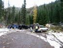
and Lynn have always been fun. We met in Issaquah at 6:15 and were at the
trailhead by 8:15. Nothing like an early start when the days are getting
short. There were a few inches of snow on Beverly Creek Road and just a
little in the parking lot. I have hiked up Earl from Standup Creek and from
Bean Creek Basin. One time we could not get across Bean Creek due to high
water and icy rocks and we were forced to ascend the ridge. We found that
we could run it all the way to the summit. Richard's plan for this trip
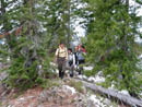
was similar. We hiked up the trail for a few minutes and then headed straight
up. The first 1000 feet went very quickly. There was not much underbrush
to impede our progress. A bigger worry was knocking rocks loose which would
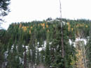
then rain down on other members or our group. Looking down towards Beverly
Creek I was surprised by the number of larch trees and the fact they were
peaking in early November.
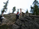
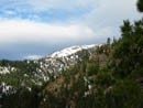
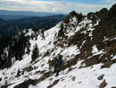
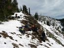
The off trail ridge route we were on reaches the summit of Earl in just under 3 miles. It goes from 3600' to 7036' gaining over 3400'. There are some ups and downs along the ridge adding a little more elevation gain. We managed to stay near the ridge top much of the way. Craig Beavon posted a report from the day before of the same route and we found his footprints much of the way. The sky was mostly filled with high clouds. That kept the sun mostly away but did not do much to harm our view. As we rose the summits of the Teanaway area came out. They are all covered with fresh snow. They look far better than the dark bare rock of summer. We encountered some snow along the ridge but not enough to cause any problems. Some places along the south side were bare. In many places there was 4 to 8 inches.
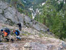
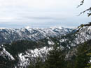
When we first saw the summit of Earl it seemed to be a long way away. The ridge is mostly forested and so we would go from great views to back into the trees again. Mt. Rainier and Mt. Adams were clear to the south. North of the Stuart Range were some more serious clouds. Higher on the ridge I could see out to Three Queens Mountain. The Cascade crest was in the clear. After passing Point 5693 the route flattened out. Before reaching the pass where the Bean Creek Trail crosses we had an obstacle to get around. A gently rising traverse took us around on the right side. The left side is too cliffy. On my previous trip a dozen years ago I remembered lots of scree. This time much of the way had a few inches of snow which made for better foot steps than the scree. The wind was now blowing steadily and we took advantage of the wind break made by the ridge top to take a break. Miller Peak and Little Navaho were now in sight and cloaked in white.
After a nice break, and now back on the ridge top, we had an easy walk to the pass. From here the summit is four tenths of a mile and 850 vertical feet away. It was mostly a thin snow cover with some bare ground and drifts up to a little more than knee deep. I topped out on the summit just about at 12:00 and right on time for lunch. The wind was strong and cold enough to make everyone climb over to the leeward side of the summit. It was fairly comfortable out of the wind. My thermometer was reading about 40 degrees. The little tarn in upper Stafford Creek Basin was frozen over and snow covered. Most of the Stuart Range was in the clear although Mt. Stuart itself had the top mostly in clouds. The overall views were outstanding.
Four weeks ago I was lounging around Lake Ann under Fortune Peak. The larch were peaking and the sun was warm. Now I could see Fortune with a solid blanket of white. We were able to have a nice long stay on top but the cold soon had us thinking about getting moving again. The first 850' down to the pass went very quickly. It would have been even faster but I couldn't resist the chance to keep photographing all the snow covered peaks. It may be quite a few months before I am back on a summit over 7000'. I have been to that pass between Bean Creek Basin and Standup Creek Basin many times. I have still never seen the trail down to Bean Creek. It has always been covered with snow. This day was no different. We plunged down the snowy slope. There was enough snow to give some traction but not enough to make it easy. Too far to the right leads to a steep gully. By angling left we stayed on reasonable terrain. Part way down we found the trail and found and lost it several times before reaching the valley bottom.
The last obstacles of the day were two crossings of Bean Creek. The basin was completely snow covered but there was not enough to hinder dropping down to the creek. I think everyone made it across with dry feet. From there it was easy going along the side of the creek. We were down to the lower crossing in no time. This one was a little trickier but no real problem. A short distance down we met up with the Beverly Creek Trail and turned left. Another half mile brought us back to the trailhead. The thin snow cover in the morning had all melted in the parking lot.
This was a fun way to do a summit I have visited often. The off trail ridge ramble was great and the fresh snow on the peaks was outstanding. The group was strong and a good group to spend a day with. This will probably be my last visit to the Teanaway until I hear Iron Peak once again calling my name next spring. That is, unless I make another ski trip back up there this winter. All in all, it was a short 6 miles round trip with a considerable 3600' gained.
Click on thumbnails to get larger pictures.
Photo Page 2
Trips - 2004
Home
The off trail ridge route we were on reaches the summit of Earl in just under 3 miles. It goes from 3600' to 7036' gaining over 3400'. There are some ups and downs along the ridge adding a little more elevation gain. We managed to stay near the ridge top much of the way. Craig Beavon posted a report from the day before of the same route and we found his footprints much of the way. The sky was mostly filled with high clouds. That kept the sun mostly away but did not do much to harm our view. As we rose the summits of the Teanaway area came out. They are all covered with fresh snow. They look far better than the dark bare rock of summer. We encountered some snow along the ridge but not enough to cause any problems. Some places along the south side were bare. In many places there was 4 to 8 inches.
When we first saw the summit of Earl it seemed to be a long way away. The ridge is mostly forested and so we would go from great views to back into the trees again. Mt. Rainier and Mt. Adams were clear to the south. North of the Stuart Range were some more serious clouds. Higher on the ridge I could see out to Three Queens Mountain. The Cascade crest was in the clear. After passing Point 5693 the route flattened out. Before reaching the pass where the Bean Creek Trail crosses we had an obstacle to get around. A gently rising traverse took us around on the right side. The left side is too cliffy. On my previous trip a dozen years ago I remembered lots of scree. This time much of the way had a few inches of snow which made for better foot steps than the scree. The wind was now blowing steadily and we took advantage of the wind break made by the ridge top to take a break. Miller Peak and Little Navaho were now in sight and cloaked in white.
After a nice break, and now back on the ridge top, we had an easy walk to the pass. From here the summit is four tenths of a mile and 850 vertical feet away. It was mostly a thin snow cover with some bare ground and drifts up to a little more than knee deep. I topped out on the summit just about at 12:00 and right on time for lunch. The wind was strong and cold enough to make everyone climb over to the leeward side of the summit. It was fairly comfortable out of the wind. My thermometer was reading about 40 degrees. The little tarn in upper Stafford Creek Basin was frozen over and snow covered. Most of the Stuart Range was in the clear although Mt. Stuart itself had the top mostly in clouds. The overall views were outstanding.
Four weeks ago I was lounging around Lake Ann under Fortune Peak. The larch were peaking and the sun was warm. Now I could see Fortune with a solid blanket of white. We were able to have a nice long stay on top but the cold soon had us thinking about getting moving again. The first 850' down to the pass went very quickly. It would have been even faster but I couldn't resist the chance to keep photographing all the snow covered peaks. It may be quite a few months before I am back on a summit over 7000'. I have been to that pass between Bean Creek Basin and Standup Creek Basin many times. I have still never seen the trail down to Bean Creek. It has always been covered with snow. This day was no different. We plunged down the snowy slope. There was enough snow to give some traction but not enough to make it easy. Too far to the right leads to a steep gully. By angling left we stayed on reasonable terrain. Part way down we found the trail and found and lost it several times before reaching the valley bottom.
The last obstacles of the day were two crossings of Bean Creek. The basin was completely snow covered but there was not enough to hinder dropping down to the creek. I think everyone made it across with dry feet. From there it was easy going along the side of the creek. We were down to the lower crossing in no time. This one was a little trickier but no real problem. A short distance down we met up with the Beverly Creek Trail and turned left. Another half mile brought us back to the trailhead. The thin snow cover in the morning had all melted in the parking lot.
This was a fun way to do a summit I have visited often. The off trail ridge ramble was great and the fresh snow on the peaks was outstanding. The group was strong and a good group to spend a day with. This will probably be my last visit to the Teanaway until I hear Iron Peak once again calling my name next spring. That is, unless I make another ski trip back up there this winter. All in all, it was a short 6 miles round trip with a considerable 3600' gained.
Trialhead |
Larch Trees |
Heading Up |
Scrambling |
Iron Peak |
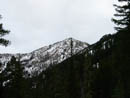
Earl Peak |
Richard |
Jolly Mountain |
Scree/Snow Traverse |
Break Time |
Photo Page 2
Trips - 2004
Home