7/30-31/04
Mt. Adams had been on my
scrambling "to do" list for a number of years. On my many trips up Mt.
St. Helens I looked across at Adams and thought how much I'd like to be
on top of it. This year I decided it was time. Gary was free the last
weekend in July and the weather cooperated nicely. To avoid some of the
crowds we decided on a
Friday - Saturday trip. I had no desire to do it in one day and wanted
some
time at 9000' to acclimatize as well. I picked Gary up at 6:30 and we
headed
south. It's a long drive. The distance down was 190 miles from north
Seattle
with a stop at the Trout Lake Ranger Station. Coming back we took a
shortcut
back to Road 23 and it was only about 180 miles. Road 23 from Randle to
Trout
Lake was very nice. 11 miles are gravel but the other 45 are paved. We
picked
up our permits at Trout Lake and headed for the trailhead. We had a
clear
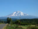
view of the mountain from near Trout Lake and had to stop to get
photos.
The road up is very good. It is partly paved then good gravel to the
Morrison
Creek Campgrounds. I have heard horror stories about the last three
miles
to Cold Springs but they are at least currently unfounded. The road is
nicely
graded and any passenger car can make it with no problems at all. There
were
a fair number of cars at the trailhead but many spaces were still
available.
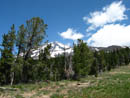
We arrived at the 5600' trailhead at about 11:20 and were packed up and ready to go at 11:40. The trail begins on an old road bed. Both my old Becky guide and old 102 Hikes book list the road going up to Timberline Campgrounds. It's closed now but makes for an easy trail. The day was already warm but not too hot. Heat is my biggest nemesis and hence my biggest worry with the late start necessitated by the long drive. There were a few clouds and enough breeze to keep me going. There was some lupine and paintbrush but the flowers were minimal. We reached the intersection with the Around the Mountain Trail having gained 700' in the first 1.3 miles. That left 3000' to gain in the last 2.7 miles to our camp spot. At about 2 miles the easy trail ended and the fun began. There was a big tree here for shade and we used it for a food and water break. We could now see the Crescent Glacier above us. The trail from here on is rocky as it crosses and climbs an old moraine. Near the base of the Crescent we found a small water source and used it to fill our water bottles.
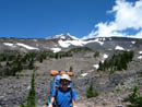
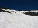
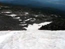
The trail turned to the left and climbed to the top of the ridge above. We decided instead to climb onto the low end of the glacier. We could see the tiny moving dots of hikers ahead of us on the glacier. The lower part was very gentle as it climbed below the ascending ridge to our left. When it began to steepen we stopped to put on crampons. The day was now hot but the snow was still fairly hard. The crampons made it much easier to climb. This was also a chance for Gary to try them out. I have two pair of ultralight crampons and could let him borrow a pair. Our plan was to climb high on the glacier then traverse to the upper section before reaching the ridge top. About the time we reached the point where we had a clear path to traverse on a big rock/boulder came tumbling down about 50' to our right. A helmet would have done no good with that rock. We quickly rethought our plan and decided to continue straight up a narrowing snow finger to the ridge directly above us. This section may have been the steepest slope of the whole trip. With crampons it was no problem.
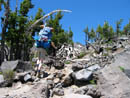
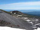
We reached the ridge at about 8000'. After climbing over the rocky ridge we dropped back onto a long snowfield. This snow led all the way up to the Lunch Counter. Looking back down to the ridge we began to see a number of rock walled tent sites. They are all over from about 7800' up to the Lunch Counter. We now had a nice view of the snowfield leading up to Pikers Peak, the false summit. Tiny dots could be seen as a few people were coming up and down the mountain. It's important to look back frequently as the snowfield breaks into several lobes as it descends. Other than following footprints it's not easy to judge the correct way down. The heat slowed us a little as well as messing with crampons and constantly stopping to take photos. Gary has a new digital camera and was having fun trying all its features. We finally reached the Lunch Counter at about 3:40, some 4 hours after we began. The bulk of visible tents were just below where the snowfield begins to ascend to Pikers Peak and just west of there. We went a little south and higher. We found a nice big walled site at about 9300'. My new Hilleberg Nallo 3 requires a fairly large spot. Our first choice was a little small but our second choice was perfect. The tent is listed as a three man and it is. It is a great and roomy tent for two guys over 6'3". The door can be configured to open in the middle or on either side. This was a useful feature as we has little room in front and had one side of the vestibule as the entrance. The huge vestibule also took both packs and pairs of boots with room left over to exit. All in all I was very pleased with the tent. All that and it worked out to only 2 1/2 lbs. per person.
We were both feeling the elevation after coming up from sea level that morning. We did manage to go for a short walk before dinner. I was happy to stop atop a rocky point but Gary still had some energy. He descended to a snowfield and continued up to a ridge to the east. He had some nice views of east side glaciers. I saw a white dot moving on the ridge across the snowfield. Soon, it descended down to the snow. It was a solitary mountain goat. I did not expect to see any large animals at 9,400'. It laid down on the snow for awhile before slowly walking away. Gary seemed to enjoy his view as he stayed on the ridge for some time. When he returned we headed back to camp for dinner. From our site the snowfield looked very steep. Angles are often deceiving but it looked about vertical. At the top was a narrow finger just before reaching Pikers Peak. Otherwise it is just one huge snowfield. The temperature remained comfortable until about 30 seconds after the sun began to set. It felt like it dropped 30 degrees instantly. We bundled up and got ready for one of the more anticipated parts of the trip. The sun setting near Mt. St. Helens lit up the sky with red and orange colors. We took several dozen photos between us. At one point I looked behind me to see a nearly full golden harvest moon rising. We missed the actual move over the horizon but enjoyed what we saw very much. Earlier we saw two people several thousand feet up towards the false summit. They were not moving. Now at dark we saw their headlamps as they were very slowly descending. They apparently just wanted to be high on the mountain at dark.
We slept very warmly in the Nallo. It was much warmer than outside. I had heard reports of mice at the Lunch Counter. I put what food I had left in my aluminum pot and strapped it shut. Gary had a tupperware container on which he put multiple straps. All our food was in ziplock bags as well. The food we left outside the tent. Our packs went inside the vestibule. By 10:00 we could hear what sounded like the scurrying of a large army of mice. There must have been a dozen of them. Short of staying awake all night there was nothing we could do about it. We had some concerns about what might be chewed up by morning. We awoke to find that the mice had done no damage at all, much to our relief. The food containers were also untouched. We had decided against an early morning climb and slept in until 6:15. By then there were already groups high on the snowfield. After a leisurely breakfast we packed up our light daypacks. My Golite Dawn packs up small in my big pack and weighs less than one pound. The day was shaping up to be clear and hot with zero wind at camp. Still, we packed up lots of cold weather clothing in case the wind was blowing on the summit.
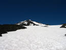
A short drop down to the snow and we were on our way. From the base of the climb the scary vertical slope showed itself to be much more moderate. Although the freezing level was 14,000' overnight the snow was hard. It wasn't icy but hard enough that crampons were very useful. With crampons on and ice axes out we headed up. We started to the right of most climbers and continued straight up. There are actually three steep slopes with a very moderate section above each one. At a moderate spot it was very easy to traverse. Part way up we angled to the left aiming for the narrow snow finger. We started out at a moderate pace and kept it up. Some others started fast and we ended up passing them higher up. The night at 9,400' helped a great deal as we both felt better at over 10,000' than we did upon reaching camp the day before. The snow finger was narrow but not as bad as it had looked from below. There is a glissade rut in it but rocks are showing through in spots. We just kept moving and reached the ridge top at 9:40. It took us 1:50 to climb up about 2400'. I was expecting to reach the summit of Pikers Peak but it was actually just a flat spot on a ridge. The false summit was to our right and maybe 100' higher.
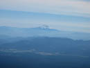
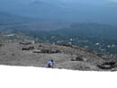
We had a food and water break here and removed our crampons. I exchanged ice axe for poles as well. The trail continued on dirt and gravel around the false summit. The actual summit was now in view. We dropped a short distance and crossed another nearly level snowfield. The next steep climb was on lose gravel. There are several "paths" up the slope. We both felt surprisingly good here and we passed one group and pulled away from another. A few hundred feet below the summit one could either walk up snow or follow a boot path to the left of it on dirt. We chose the snow and soon were on top. With our break at the false summit it took us exactly 3 hours to reach the top. The old building was partly in the open. Both of us went to the very top of the roof. The summit ridge continues for several hundred yards to the east. That looked like the high point of the mountain sans the building. The air at 12,276' was definitely thinner than at 9,400'. I felt fine but seemed to have a decided lack of ambition to do much exploring. A walk to the east did give nice views down to meadows on the Yakima Reservation side of the mountain. Mt. Hood was visible but it was hazy to the south. We did not see Mt. Jefferson or any other Oregon mountains. St. Helens was clear and everything to the north was visible. We could just pick out Baker, Glacier Peak, and Mt. Stuart. There were 30+ people on the summit at any given time. The wind was almost calm and with long pants and a few layers it was very comfortable. We spent a little over an hour on top.
At 12:00 we headed down. Plunging down the loose gravel was easy. We made good time. Also, near the summit is the very unmistakable odor of sulfur. I knew they mined it on the summit long ago. I did not expect to smell it. Anyway, we reached the false summit/ridge top in 26 minutes. I was contemplating putting crampons back on when quite a number of climbers headed down without them. We chose to go without. The snow had softened remarkably in just a few hours. We plunged down through the snow finger and below that the glissade chute looked good. Gary went first and I jumped in behind him. The snow was soft enough to keep our speed down but fast enough to keep moving. The next thousand feet went very fast. The many twists and turns in the chute added to the fun. Farther down it appeared to have melted out to rocks and we chose to exit. We traversed to the east until we had a clear runout and took off again. Without a chute it was much bumpier as I got airborne several times. It was also harder on my rear with each landing. This glissade took us all the way to the bottom. It was 57 minutes from the summit to the Lunch Counter.
We packed up camp and headed down at around 2:00. More of the Saturday afternoon crowd was streaming up the mountain. Another stream joined us for the hike down. We chose to hike the trail down instead of dropping down the Crescent Glacier. That route is fine although it is rocky and a bit of a knee grinder. As we dropped the temperature began to soar. I would have been dead going up in those conditions. That 4 miles seemed to take forever but in about 2 hours we were back at the car. We took a shortcut back to Road 23 without going to Trout Lake and stopped in Morton for a brief meal. It was almost 10:00 before I arrived home. This trip turned out to be lots of fun. We had some steep snow travel, a high summit, quite a sunset, pesky rodents, falling rocks, and almost zero bugs. It was well worth the effort.
Click on thumbnails to get larger pictures.
Photo Page 2
Trips - 2004
Home
We arrived at the 5600' trailhead at about 11:20 and were packed up and ready to go at 11:40. The trail begins on an old road bed. Both my old Becky guide and old 102 Hikes book list the road going up to Timberline Campgrounds. It's closed now but makes for an easy trail. The day was already warm but not too hot. Heat is my biggest nemesis and hence my biggest worry with the late start necessitated by the long drive. There were a few clouds and enough breeze to keep me going. There was some lupine and paintbrush but the flowers were minimal. We reached the intersection with the Around the Mountain Trail having gained 700' in the first 1.3 miles. That left 3000' to gain in the last 2.7 miles to our camp spot. At about 2 miles the easy trail ended and the fun began. There was a big tree here for shade and we used it for a food and water break. We could now see the Crescent Glacier above us. The trail from here on is rocky as it crosses and climbs an old moraine. Near the base of the Crescent we found a small water source and used it to fill our water bottles.
The trail turned to the left and climbed to the top of the ridge above. We decided instead to climb onto the low end of the glacier. We could see the tiny moving dots of hikers ahead of us on the glacier. The lower part was very gentle as it climbed below the ascending ridge to our left. When it began to steepen we stopped to put on crampons. The day was now hot but the snow was still fairly hard. The crampons made it much easier to climb. This was also a chance for Gary to try them out. I have two pair of ultralight crampons and could let him borrow a pair. Our plan was to climb high on the glacier then traverse to the upper section before reaching the ridge top. About the time we reached the point where we had a clear path to traverse on a big rock/boulder came tumbling down about 50' to our right. A helmet would have done no good with that rock. We quickly rethought our plan and decided to continue straight up a narrowing snow finger to the ridge directly above us. This section may have been the steepest slope of the whole trip. With crampons it was no problem.
We reached the ridge at about 8000'. After climbing over the rocky ridge we dropped back onto a long snowfield. This snow led all the way up to the Lunch Counter. Looking back down to the ridge we began to see a number of rock walled tent sites. They are all over from about 7800' up to the Lunch Counter. We now had a nice view of the snowfield leading up to Pikers Peak, the false summit. Tiny dots could be seen as a few people were coming up and down the mountain. It's important to look back frequently as the snowfield breaks into several lobes as it descends. Other than following footprints it's not easy to judge the correct way down. The heat slowed us a little as well as messing with crampons and constantly stopping to take photos. Gary has a new digital camera and was having fun trying all its features. We finally reached the Lunch Counter at about 3:40, some 4 hours after we began. The bulk of visible tents were just below where the snowfield begins to ascend to Pikers Peak and just west of there. We went a little south and higher. We found a nice big walled site at about 9300'. My new Hilleberg Nallo 3 requires a fairly large spot. Our first choice was a little small but our second choice was perfect. The tent is listed as a three man and it is. It is a great and roomy tent for two guys over 6'3". The door can be configured to open in the middle or on either side. This was a useful feature as we has little room in front and had one side of the vestibule as the entrance. The huge vestibule also took both packs and pairs of boots with room left over to exit. All in all I was very pleased with the tent. All that and it worked out to only 2 1/2 lbs. per person.
We were both feeling the elevation after coming up from sea level that morning. We did manage to go for a short walk before dinner. I was happy to stop atop a rocky point but Gary still had some energy. He descended to a snowfield and continued up to a ridge to the east. He had some nice views of east side glaciers. I saw a white dot moving on the ridge across the snowfield. Soon, it descended down to the snow. It was a solitary mountain goat. I did not expect to see any large animals at 9,400'. It laid down on the snow for awhile before slowly walking away. Gary seemed to enjoy his view as he stayed on the ridge for some time. When he returned we headed back to camp for dinner. From our site the snowfield looked very steep. Angles are often deceiving but it looked about vertical. At the top was a narrow finger just before reaching Pikers Peak. Otherwise it is just one huge snowfield. The temperature remained comfortable until about 30 seconds after the sun began to set. It felt like it dropped 30 degrees instantly. We bundled up and got ready for one of the more anticipated parts of the trip. The sun setting near Mt. St. Helens lit up the sky with red and orange colors. We took several dozen photos between us. At one point I looked behind me to see a nearly full golden harvest moon rising. We missed the actual move over the horizon but enjoyed what we saw very much. Earlier we saw two people several thousand feet up towards the false summit. They were not moving. Now at dark we saw their headlamps as they were very slowly descending. They apparently just wanted to be high on the mountain at dark.
We slept very warmly in the Nallo. It was much warmer than outside. I had heard reports of mice at the Lunch Counter. I put what food I had left in my aluminum pot and strapped it shut. Gary had a tupperware container on which he put multiple straps. All our food was in ziplock bags as well. The food we left outside the tent. Our packs went inside the vestibule. By 10:00 we could hear what sounded like the scurrying of a large army of mice. There must have been a dozen of them. Short of staying awake all night there was nothing we could do about it. We had some concerns about what might be chewed up by morning. We awoke to find that the mice had done no damage at all, much to our relief. The food containers were also untouched. We had decided against an early morning climb and slept in until 6:15. By then there were already groups high on the snowfield. After a leisurely breakfast we packed up our light daypacks. My Golite Dawn packs up small in my big pack and weighs less than one pound. The day was shaping up to be clear and hot with zero wind at camp. Still, we packed up lots of cold weather clothing in case the wind was blowing on the summit.
A short drop down to the snow and we were on our way. From the base of the climb the scary vertical slope showed itself to be much more moderate. Although the freezing level was 14,000' overnight the snow was hard. It wasn't icy but hard enough that crampons were very useful. With crampons on and ice axes out we headed up. We started to the right of most climbers and continued straight up. There are actually three steep slopes with a very moderate section above each one. At a moderate spot it was very easy to traverse. Part way up we angled to the left aiming for the narrow snow finger. We started out at a moderate pace and kept it up. Some others started fast and we ended up passing them higher up. The night at 9,400' helped a great deal as we both felt better at over 10,000' than we did upon reaching camp the day before. The snow finger was narrow but not as bad as it had looked from below. There is a glissade rut in it but rocks are showing through in spots. We just kept moving and reached the ridge top at 9:40. It took us 1:50 to climb up about 2400'. I was expecting to reach the summit of Pikers Peak but it was actually just a flat spot on a ridge. The false summit was to our right and maybe 100' higher.
We had a food and water break here and removed our crampons. I exchanged ice axe for poles as well. The trail continued on dirt and gravel around the false summit. The actual summit was now in view. We dropped a short distance and crossed another nearly level snowfield. The next steep climb was on lose gravel. There are several "paths" up the slope. We both felt surprisingly good here and we passed one group and pulled away from another. A few hundred feet below the summit one could either walk up snow or follow a boot path to the left of it on dirt. We chose the snow and soon were on top. With our break at the false summit it took us exactly 3 hours to reach the top. The old building was partly in the open. Both of us went to the very top of the roof. The summit ridge continues for several hundred yards to the east. That looked like the high point of the mountain sans the building. The air at 12,276' was definitely thinner than at 9,400'. I felt fine but seemed to have a decided lack of ambition to do much exploring. A walk to the east did give nice views down to meadows on the Yakima Reservation side of the mountain. Mt. Hood was visible but it was hazy to the south. We did not see Mt. Jefferson or any other Oregon mountains. St. Helens was clear and everything to the north was visible. We could just pick out Baker, Glacier Peak, and Mt. Stuart. There were 30+ people on the summit at any given time. The wind was almost calm and with long pants and a few layers it was very comfortable. We spent a little over an hour on top.
At 12:00 we headed down. Plunging down the loose gravel was easy. We made good time. Also, near the summit is the very unmistakable odor of sulfur. I knew they mined it on the summit long ago. I did not expect to smell it. Anyway, we reached the false summit/ridge top in 26 minutes. I was contemplating putting crampons back on when quite a number of climbers headed down without them. We chose to go without. The snow had softened remarkably in just a few hours. We plunged down through the snow finger and below that the glissade chute looked good. Gary went first and I jumped in behind him. The snow was soft enough to keep our speed down but fast enough to keep moving. The next thousand feet went very fast. The many twists and turns in the chute added to the fun. Farther down it appeared to have melted out to rocks and we chose to exit. We traversed to the east until we had a clear runout and took off again. Without a chute it was much bumpier as I got airborne several times. It was also harder on my rear with each landing. This glissade took us all the way to the bottom. It was 57 minutes from the summit to the Lunch Counter.
We packed up camp and headed down at around 2:00. More of the Saturday afternoon crowd was streaming up the mountain. Another stream joined us for the hike down. We chose to hike the trail down instead of dropping down the Crescent Glacier. That route is fine although it is rocky and a bit of a knee grinder. As we dropped the temperature began to soar. I would have been dead going up in those conditions. That 4 miles seemed to take forever but in about 2 hours we were back at the car. We took a shortcut back to Road 23 without going to Trout Lake and stopped in Morton for a brief meal. It was almost 10:00 before I arrived home. This trip turned out to be lots of fun. We had some steep snow travel, a high summit, quite a sunset, pesky rodents, falling rocks, and almost zero bugs. It was well worth the effort.
Mt. Adams |
False Summit |
Gary And Crescent |
Trail In Moraine |
Crescent Glacier |
Top Of Crescent |
South Butte |
Snowfield To Counter |
Mt. Hood |
Camp Sites |
Photo Page 2
Trips - 2004
Home