4-09-04
My first trip up South Bessemer
was in February of 2003. That day was cold and cloudy. I had no views
at all. On the way down it snowed and then rained. This day was the exact
opposite. The forecast was for sunny skies and a high near 70 degrees.
Not bad or early April in Seattle. I work in about the only business which
takes off Good Friday as a holiday. It makes for a chance to do a close in
hike and not see anyone. I had a reasonably early start and was on the route
by 8:50. It was a Friday and I was very surprised to see two vehicles parked
by the gate. They must have gone up the CCC road because I did not see another
person the whole day.
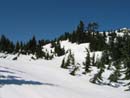
The road is in excellent shape. There are no big trees down. There are a few very small ones high up but they are tiny and can be easily stepped over. There is no water on the road. Signs of recent maintenance are apparent. The lower road is nicely forested. Several switchbacks are rocky but most of the road is fairly smooth. The two creek crossings are running fast but can easily be crossed with dry feet. When I reached that strange wheeled piece of equipment I saw on my first trip the small forest around it had been cut. It must have been used last year. At about 4 miles the snow began. After a few patchy spots it quickly deepened. There was no more bare road. The snow was soft. I sank about 3-6 inches on each step. At the next switchback I had my first good views out. Mailbox Peak was down valley and the Pratt River Valley was across from me.
The road starts out very gently and just keeps getting steeper. The steep road and soft snow made for slow going. Although I had been here before it was totally different. Before I could see 100 feet. Today it was crystal clear. The bright sun and snow was blinding. I had on sunglasses and plenty of sun screen. I finally decided to put on snowshoes. I didn't expect much difference but in fact it was much better. With renewed vigor I climbed up to the intersection just below the saddle. On my previous visit I went left to the saddle. From there I bumble my way to the summit via a long unused spur road. I was almost sure that going right and avoiding the saddle was a better way. I turned to the right to find out. The road traversed for a long way. As it turned to the east side the road was covered with sloping snow. If it was icy I would not have continued. As soft as it was my snowshoes had plenty of bite.
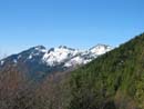
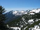
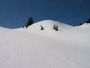
The road finally switched back at a flat area. The views really improved here. The Middle Fork Valley was now visible all the way to the Cascade Crest. I could see Thomson and Chikamin Peaks. The road began to traverse across a steep slope with snow at a 45 degree angle. It would be far too difficult to continue on the road. Instead I decided to follow the ridge up. What looked like it might be the summit was now in sight. There were no tracks in the smooth snow. I climbed at a moderate grade then reached a steep section. The climbing was not hard. The worst part was weaving between some trees and not falling into weak spots and or tree wells. Above this point the ridge climbed at a steady grade. As I neared the top it was clear I had again found the road. The last part was a traverse across a very steep slope. I did not have an ice axe and did not want to cross it. After a much needed food break I decided to try scrambling up the south side of the ridge. It looked to be bare so I took off my snowshoes, packed my poles and took off. The slope was dirt, slide alder, and a few downed logs. It was not too bad at all. In short order I topped out and immediately recognized the lower of the two summits.
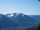
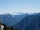
A short slog led to the taller summit. The very top was a knife edge of snow so I was happy to stop a few feet short. The views were now 360 degrees. The summits of Bessemer proper were just down the ridge. Downtown Seattle was visible. Most unexpectedly, four of the five volcanoes were visible. I could see Adams, Rainier, Baker, and Glacier Peak. I didn't expect that from the top of a little 5028' peak just down the ridge from Mt. Si. My previous trip took 3:17 to the top. With the soft snow this one took 4:15. I was beat. Since it was after 1:00 already I only spent 30 minutes on top. The views are really great up there. Better than one would expect from such a close in and low summit. I scrambled back down the ridge and put on snowshoes again. The way down was much easier and much faster. In short order I was back down to near the saddle. The rest of the way was just a long slog. I finally reached my car at 4:20. It was a long 7 1/2 hour hike. Totals for the day were 13 miles and 4200' gained. It was great to do this trip again and finally get the terrific views.
Click on thumbnails to get larger pictures.
Photo Page 2
Trips 2004
Home
The road is in excellent shape. There are no big trees down. There are a few very small ones high up but they are tiny and can be easily stepped over. There is no water on the road. Signs of recent maintenance are apparent. The lower road is nicely forested. Several switchbacks are rocky but most of the road is fairly smooth. The two creek crossings are running fast but can easily be crossed with dry feet. When I reached that strange wheeled piece of equipment I saw on my first trip the small forest around it had been cut. It must have been used last year. At about 4 miles the snow began. After a few patchy spots it quickly deepened. There was no more bare road. The snow was soft. I sank about 3-6 inches on each step. At the next switchback I had my first good views out. Mailbox Peak was down valley and the Pratt River Valley was across from me.
The road starts out very gently and just keeps getting steeper. The steep road and soft snow made for slow going. Although I had been here before it was totally different. Before I could see 100 feet. Today it was crystal clear. The bright sun and snow was blinding. I had on sunglasses and plenty of sun screen. I finally decided to put on snowshoes. I didn't expect much difference but in fact it was much better. With renewed vigor I climbed up to the intersection just below the saddle. On my previous visit I went left to the saddle. From there I bumble my way to the summit via a long unused spur road. I was almost sure that going right and avoiding the saddle was a better way. I turned to the right to find out. The road traversed for a long way. As it turned to the east side the road was covered with sloping snow. If it was icy I would not have continued. As soft as it was my snowshoes had plenty of bite.
The road finally switched back at a flat area. The views really improved here. The Middle Fork Valley was now visible all the way to the Cascade Crest. I could see Thomson and Chikamin Peaks. The road began to traverse across a steep slope with snow at a 45 degree angle. It would be far too difficult to continue on the road. Instead I decided to follow the ridge up. What looked like it might be the summit was now in sight. There were no tracks in the smooth snow. I climbed at a moderate grade then reached a steep section. The climbing was not hard. The worst part was weaving between some trees and not falling into weak spots and or tree wells. Above this point the ridge climbed at a steady grade. As I neared the top it was clear I had again found the road. The last part was a traverse across a very steep slope. I did not have an ice axe and did not want to cross it. After a much needed food break I decided to try scrambling up the south side of the ridge. It looked to be bare so I took off my snowshoes, packed my poles and took off. The slope was dirt, slide alder, and a few downed logs. It was not too bad at all. In short order I topped out and immediately recognized the lower of the two summits.
A short slog led to the taller summit. The very top was a knife edge of snow so I was happy to stop a few feet short. The views were now 360 degrees. The summits of Bessemer proper were just down the ridge. Downtown Seattle was visible. Most unexpectedly, four of the five volcanoes were visible. I could see Adams, Rainier, Baker, and Glacier Peak. I didn't expect that from the top of a little 5028' peak just down the ridge from Mt. Si. My previous trip took 3:17 to the top. With the soft snow this one took 4:15. I was beat. Since it was after 1:00 already I only spent 30 minutes on top. The views are really great up there. Better than one would expect from such a close in and low summit. I scrambled back down the ridge and put on snowshoes again. The way down was much easier and much faster. In short order I was back down to near the saddle. The rest of the way was just a long slog. I finally reached my car at 4:20. It was a long 7 1/2 hour hike. Totals for the day were 13 miles and 4200' gained. It was great to do this trip again and finally get the terrific views.
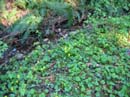
Flowers |
Snow Above |
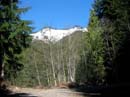
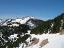
Green Mt. |
Mailbox Peak |
Transparent Leaf |
Snowy Road |
Green Mt. |
Cascade Crest |
Open Slopes |
Final Slope |
Photo Page 2
Trips 2004
Home