5-25-05
This mountain bike loop had been on the back burner
for several years. Gary and I wanted to get in a fairly long after work
bike trip. Gary had never been up the Iron Horse trail or through the Snoqualmie
tunnel. I had done much of the railroad grade but not from the McClellan
Butte trail to Humpback Creek. This week we were both free and the weather
looked to be perfect. I unexpectedly met Gary at milepost 29 near North
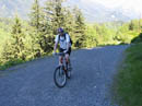
Bend. He drove up behind me and we drove together to the trailhead. The starting
elevation is about 1200'. By 3:55 we were on our way. The gated road up
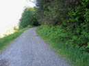
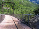
to the grade was the toughest stretch of the the day. Once on the grade
we had a mileage sign showing 13.3 miles to the tunnel.
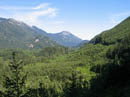
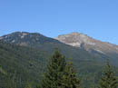
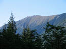
I did not take a camera but Gary did. We made numerous stops for photos. When I get his photos I will post many of them here. The first thing we noticed on the grade was the very strong east wind blowing right in our faces. I feared that over 13 miles uphill into that wind would about wipe me out. I was surprised to find that much of the old grade is protected from the wind by trees on the north side. I thought all the logging would leave us out in the open much more. We did have periodic views out to the peaks on the north side of the valley but the wind proved not to be a big problem.
Early on the trail was lined with many types of wildflowers. This too was an unexpected bonus. There was paintbrush, a few beargrass, and many small colorful flowers as we zoomed by. From the start to the summit of Snoqualmie Pass is about 18.5 miles, all uphill, gaining 1800'. It is not steep at all along the grade but it is all uphill. We were hard pressed to even average 8-9 mph. There was one waterfall dropping vertically from forest above to the grade that was especially neat. It was in the mid 70s when we started but this route hugs the south wall of the valley, is largely forested, and so was nicely shaded much of the way.
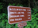
We passed the snowshed near Humpback Creek, crossed the trestle, and met the Annette Lake Trail crossing. From there it was a quick 1.6 miles to the tunnel. It took us exactly 2 hours to reach the tunnel with quite a few photo stops. The picnic tables made a good spot for a "dinner" snack. We each brought a Princeton Tech Aurora led headlamp for the tunnel. Gary thought he had his old focused beam headlamp but it was not in his pack. We quickly found that the led lamps were nearly worthless. The beam could slightly brighten the grade just in front of us but that was all. It was closer to riding in the dark than with a light. It did make the 2 miles of the tunnel that much more interesting.
It was still at least 70 degrees when we entered the tunnel. Inside it was about 45 degrees. Even with fingerless riding gloves my hands were nearly numb by the time we made it through. I did put on a long sleeve shirt but a jacket would have been useful. Once out of the tunnel we scrambled up the hillside to the road above. Now we had 2.5 miles uphill on pavement to the summit. We gained 400' here but it wasn't as bad as I was expecting. The road was as quiet as I've ever seen it. A few cars came down and only one car passed us on the ride up.
The Travelers Rest was a last chance to use the bathroom and fill up with water. Now it was all downhill. Once under the freeway we turned onto the old road down to Denny Creek. It is nicely paved with lots of twisty turns and a few tight switchbacks. The speed limit is 30 and we were able to exceed it in a number of sections. The 6 or so miles to the Denny Creek interchange took less than 20 minutes. We could have taken the freeway all the way back but chose to take Tinkham Road instead. Crossing over to the Annette Lake turnoff we went right on the dirt road.
The road turned out to be much nicer than I expected. It is a steady gently downhill grade the whole way. Potholes were few and far between. Keeping up 12-15 mph was no problem, even with tired legs. There was a creek crossing where the water is channeled over a concrete road section. It was wide but not deep and easy to cross. About 6 miles later we reached the Exit 42 interchange near the McClellan Butte trailhead. Now we had 2 miles of freeway to ride on. It was steep enough to allow for good speed. The big trucks were a little bothersome but not nearly as much as an idiot in a van who laid on his horn as he went by. I about went off the road at 20+ mph.
We exited the freeway at Exit 38 westbound which is at milepost 40. Go figure. The last couple miles on an old highway section was nice and easy. We arrived back at our cars at 8:30. We took 4:30 of which about 3:30 was spent biking. The total distance was 35 miles gaining 2000'. This turned out to be a great after work trip. The railroad grade was much better than I expected. The tunnel was a blast especially with our wimpy lights. The high speed twisty downhill was a blast. This is a loop that I'm sure I will get out and do again. All photos courtesy of Gary Westerlund.
Click on thumbnails to get larger pictures.
Photo Page 2
Trips - 2005
Home
I did not take a camera but Gary did. We made numerous stops for photos. When I get his photos I will post many of them here. The first thing we noticed on the grade was the very strong east wind blowing right in our faces. I feared that over 13 miles uphill into that wind would about wipe me out. I was surprised to find that much of the old grade is protected from the wind by trees on the north side. I thought all the logging would leave us out in the open much more. We did have periodic views out to the peaks on the north side of the valley but the wind proved not to be a big problem.
Early on the trail was lined with many types of wildflowers. This too was an unexpected bonus. There was paintbrush, a few beargrass, and many small colorful flowers as we zoomed by. From the start to the summit of Snoqualmie Pass is about 18.5 miles, all uphill, gaining 1800'. It is not steep at all along the grade but it is all uphill. We were hard pressed to even average 8-9 mph. There was one waterfall dropping vertically from forest above to the grade that was especially neat. It was in the mid 70s when we started but this route hugs the south wall of the valley, is largely forested, and so was nicely shaded much of the way.
We passed the snowshed near Humpback Creek, crossed the trestle, and met the Annette Lake Trail crossing. From there it was a quick 1.6 miles to the tunnel. It took us exactly 2 hours to reach the tunnel with quite a few photo stops. The picnic tables made a good spot for a "dinner" snack. We each brought a Princeton Tech Aurora led headlamp for the tunnel. Gary thought he had his old focused beam headlamp but it was not in his pack. We quickly found that the led lamps were nearly worthless. The beam could slightly brighten the grade just in front of us but that was all. It was closer to riding in the dark than with a light. It did make the 2 miles of the tunnel that much more interesting.
It was still at least 70 degrees when we entered the tunnel. Inside it was about 45 degrees. Even with fingerless riding gloves my hands were nearly numb by the time we made it through. I did put on a long sleeve shirt but a jacket would have been useful. Once out of the tunnel we scrambled up the hillside to the road above. Now we had 2.5 miles uphill on pavement to the summit. We gained 400' here but it wasn't as bad as I was expecting. The road was as quiet as I've ever seen it. A few cars came down and only one car passed us on the ride up.
The Travelers Rest was a last chance to use the bathroom and fill up with water. Now it was all downhill. Once under the freeway we turned onto the old road down to Denny Creek. It is nicely paved with lots of twisty turns and a few tight switchbacks. The speed limit is 30 and we were able to exceed it in a number of sections. The 6 or so miles to the Denny Creek interchange took less than 20 minutes. We could have taken the freeway all the way back but chose to take Tinkham Road instead. Crossing over to the Annette Lake turnoff we went right on the dirt road.
The road turned out to be much nicer than I expected. It is a steady gently downhill grade the whole way. Potholes were few and far between. Keeping up 12-15 mph was no problem, even with tired legs. There was a creek crossing where the water is channeled over a concrete road section. It was wide but not deep and easy to cross. About 6 miles later we reached the Exit 42 interchange near the McClellan Butte trailhead. Now we had 2 miles of freeway to ride on. It was steep enough to allow for good speed. The big trucks were a little bothersome but not nearly as much as an idiot in a van who laid on his horn as he went by. I about went off the road at 20+ mph.
We exited the freeway at Exit 38 westbound which is at milepost 40. Go figure. The last couple miles on an old highway section was nice and easy. We arrived back at our cars at 8:30. We took 4:30 of which about 3:30 was spent biking. The total distance was 35 miles gaining 2000'. This turned out to be a great after work trip. The railroad grade was much better than I expected. The tunnel was a blast especially with our wimpy lights. The high speed twisty downhill was a blast. This is a loop that I'm sure I will get out and do again. All photos courtesy of Gary Westerlund.
Top Of The Hill |
Mileage |
Railroad Grade |
SF Snoqualmie Valley |
Early Trestle |
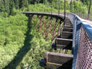
Trestle Curve |
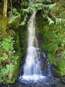
Waterfall |
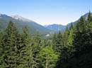
Granite Mountain |
Granite Again |
P Cubed |
Photo Page 2
Trips - 2005
Home