7-17-05
Kaleetan Peak had long been on my list of peaks to
summit. The summit looks so steep from every angle that it's hard to believe
it is only a scramble. Suzanne and "Summit Sadie", the golden retriever,
came along. I did 16 miles the day before and hoped I had enough energy
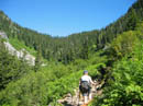
left to make it up and down. We started up the Denny Creek Trail at 8:30.
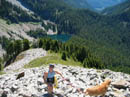
A nice steady pace had us at Melakwa Lake in just under 2 hours. There is
a gully approach from up the valley near Melakwa Pass and a ridge route
from the lake. With Sadie along, we chose the ridge. The route begins as
the trail to the outhouse and turns uphill before reaching it. In sections
it looks like real tread but mostly is boot built. There are enough boots
to make it obvious most of the way.
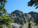
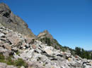
We soon reached a few short steep scramble sections that I thought Sadie would not be able to get up but she used four claw drive to run right up them. The route leaves forest for a short talus section then goes back into the trees. It was a little sketchy here but not a problem. We exited the forest and began a heather and rock slog up to point 5700'. At the top the ridge angles a little to the right and near 360 degree views present themselves. The summit is finally in sight as well as Mt. Rainier and numerous others peaks. Beyond here the ridge is a trees, rock, and heather meadow.
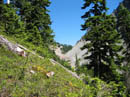
When the ridge became too difficult the route dropped down to the left. The route is on heather and grass. The top part was wet and muddy. Descending this was actually one of the hardest parts of the trip. We gingerly worked our way down and as the ground became drier the going was much easier. After dropping several hundred feet we reached the upper part of a rock slope to a basin below. The route contours just below cliffs and is generally level. There were a number of rock cairns along here. At the other side the route turned straight up in heather along the edge of a talus field. The ridge is attained at a saddle just below the summit of Kaleetan. The gully route reaches the ridge from the other side at this point. This was a good spot to have part of our lunches.
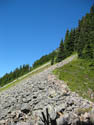
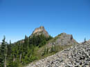
The trail climbs up from the saddle. It was mostly dirt with some boulders to cross as well. We met the second group of the day here. The couple had two dogs which both made the summit. They did warn about the dogs triggering loose rocks. That was a pertinent point. We soon reached the base of the summit gully. The ridge leading up to the gully looked awfully steep from viewpoints on the route up. It turned out to be easy. The gully looked to be a sheer cliff from those same viewpoints. In reality, it's a bit steep but not all that bad. It is full of loose rock though. After a short debate we decided to go on up with Sadie. She seemed to have an easier time scrambling the gully than we did. I found that there was some good rock on the sides that was better than the loose crud in the middle. Either way works fine. The gully is only about 150'. We were soon on the summit.
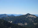
There is a register but no pen or pencil. There is also no notebook but there are a few pieces of paper. I would suggest anyone heading up soon should take a pen to leave. The views from the summit are spectacular. Rainier, Baker, Glacier, and Adams were very clear. St. Helens was the only volcano we could not see. Melakwa Lakes are laid out far below. Chair Peak is across the valley and half of Snow Lake is visible. Chair Peak Lake is right below and Gem Lake is not far away. We could also see Tuscohatchie and Pratt Lakes plus the trail between them. The Granite Mountain Lookout was below Mt. Rainier. Snoqualmie Pass was in a gap, most all the Cascade crest summits were in the clear, and of course Mt. Stuart loomed to the east. It was hot with not a cloud in the sky. The view was well worth the effort.
After soaking up the views and finishing lunch it was time to head on down. We found that it worked well for me to go down part way and get well off to one side on rock. I then called Sadie who scrambled down to me. Suzanne then caught up. This removed any threat of getting nailed by speeding rocks. We were soon down the gully and back on trail. Dropping back down to the ridge top then down to the basin went quick. The rock traverse was no problem. The climb back up the wet heather and grass was much easier than the down climb. I was thankful that this was the last big uphill as I was about out of gas. Suzanne did the 200 mile STP bike ride the previous Saturday so I think she was a little tired as well.
Back on the ridge it should have been a straight forward though steep hike back to the lake. Unfortunately we screwed up a little. After passing Point 5700 the route turns a little to the left and descents rock and heather. We managed to keep going on an incorrect ridge. So much for short term memory. The route we were on was non existent and after dropping a short distance we climbed back up to the ridge top again. Looking over the other side it was clear where we should have been. Now it was a fast though knee busting drop back to the lake. With water about gone and 80 degree heat I was very happy to see Melakwa Lake again. Sadie and Suzanne went in and I doused myself with cold water.
The hike back out was non eventful but seemed like more than 4 miles. All three of us were plenty tired when we reached the parking lot. I'm glad to have finally summited a peak I have been looking at from many angles for many years. The route is not a hike but is a very reasonable scramble. The summit view was among the best I have ever had. It was well worth the effort.
Click on thumbnails to get larger pictures.
Photo Page 2
Trips - 2005
Home
We soon reached a few short steep scramble sections that I thought Sadie would not be able to get up but she used four claw drive to run right up them. The route leaves forest for a short talus section then goes back into the trees. It was a little sketchy here but not a problem. We exited the forest and began a heather and rock slog up to point 5700'. At the top the ridge angles a little to the right and near 360 degree views present themselves. The summit is finally in sight as well as Mt. Rainier and numerous others peaks. Beyond here the ridge is a trees, rock, and heather meadow.
When the ridge became too difficult the route dropped down to the left. The route is on heather and grass. The top part was wet and muddy. Descending this was actually one of the hardest parts of the trip. We gingerly worked our way down and as the ground became drier the going was much easier. After dropping several hundred feet we reached the upper part of a rock slope to a basin below. The route contours just below cliffs and is generally level. There were a number of rock cairns along here. At the other side the route turned straight up in heather along the edge of a talus field. The ridge is attained at a saddle just below the summit of Kaleetan. The gully route reaches the ridge from the other side at this point. This was a good spot to have part of our lunches.
The trail climbs up from the saddle. It was mostly dirt with some boulders to cross as well. We met the second group of the day here. The couple had two dogs which both made the summit. They did warn about the dogs triggering loose rocks. That was a pertinent point. We soon reached the base of the summit gully. The ridge leading up to the gully looked awfully steep from viewpoints on the route up. It turned out to be easy. The gully looked to be a sheer cliff from those same viewpoints. In reality, it's a bit steep but not all that bad. It is full of loose rock though. After a short debate we decided to go on up with Sadie. She seemed to have an easier time scrambling the gully than we did. I found that there was some good rock on the sides that was better than the loose crud in the middle. Either way works fine. The gully is only about 150'. We were soon on the summit.
There is a register but no pen or pencil. There is also no notebook but there are a few pieces of paper. I would suggest anyone heading up soon should take a pen to leave. The views from the summit are spectacular. Rainier, Baker, Glacier, and Adams were very clear. St. Helens was the only volcano we could not see. Melakwa Lakes are laid out far below. Chair Peak is across the valley and half of Snow Lake is visible. Chair Peak Lake is right below and Gem Lake is not far away. We could also see Tuscohatchie and Pratt Lakes plus the trail between them. The Granite Mountain Lookout was below Mt. Rainier. Snoqualmie Pass was in a gap, most all the Cascade crest summits were in the clear, and of course Mt. Stuart loomed to the east. It was hot with not a cloud in the sky. The view was well worth the effort.
After soaking up the views and finishing lunch it was time to head on down. We found that it worked well for me to go down part way and get well off to one side on rock. I then called Sadie who scrambled down to me. Suzanne then caught up. This removed any threat of getting nailed by speeding rocks. We were soon down the gully and back on trail. Dropping back down to the ridge top then down to the basin went quick. The rock traverse was no problem. The climb back up the wet heather and grass was much easier than the down climb. I was thankful that this was the last big uphill as I was about out of gas. Suzanne did the 200 mile STP bike ride the previous Saturday so I think she was a little tired as well.
Back on the ridge it should have been a straight forward though steep hike back to the lake. Unfortunately we screwed up a little. After passing Point 5700 the route turns a little to the left and descents rock and heather. We managed to keep going on an incorrect ridge. So much for short term memory. The route we were on was non existent and after dropping a short distance we climbed back up to the ridge top again. Looking over the other side it was clear where we should have been. Now it was a fast though knee busting drop back to the lake. With water about gone and 80 degree heat I was very happy to see Melakwa Lake again. Sadie and Suzanne went in and I doused myself with cold water.
The hike back out was non eventful but seemed like more than 4 miles. All three of us were plenty tired when we reached the parking lot. I'm glad to have finally summited a peak I have been looking at from many angles for many years. The route is not a hike but is a very reasonable scramble. The summit view was among the best I have ever had. It was well worth the effort.
Denny Ck Trail |
Chair Peak |
Melakwa Pass |
Rocky Ridge |
View Of Summit |
Granite Mountain |
Melakwa Lake |
Looks Awfully Steep |
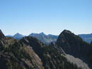
Three Queens |
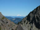
Glacier Peak |
Photo Page 2
Trips - 2005
Home