2-05-05
Tuesday I was hiking to over 5150' on Bandera Mountain
wearing shorts and short sleeves without seeing more than a patch of snow.
Friday brought new snow for the first time in many weeks. I had to get
out and see some. After being sick most of January I also wanted to get
in a long hike. I had the best of both worlds with a hike up West Rattlesnake
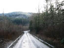
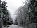
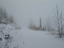
Mountain via the road. Ugly roads take on a very different appearance with
a coating of fresh snow. The start is near the intersection of I-90 and Highway
18. I was on my way at 9:40. Although the elevation was only 900' there was
a dusting of snow on the road at the gate. Thankfully the gate was locked
so there would be no cars to deal with. The first 20 minutes is a matter
of getting past the power substation. Once beyond, the going gets much better.
The first 2 1/2 miles are nearly flat and I set a fast pace. It was in
the upper 30s with a cold wind so I needed to keep moving to stay warm.
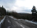
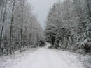
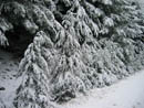
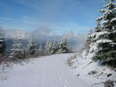
At 2 1/2 miles the road begins to climb. Soon after that a bicyclist passed me. With the steep road and the snow he slowed down and I was able to catch up. There is no way I could have biked up that road. At the top of the hill he went left and I stayed right. I reached the 4 mile marker in 63 minutes. The route gained only 800' to there. For the first 3 1/2 miles there were tire tracks in the fresh snow. From there on the snow was untouched. The needed left turn at 4 3/4 miles was gated. I turned there and began to climb. The snow was now a few inches deep and the trees were completely flocked. The snow created a cushion underfoot making the hard road very easy to walk.
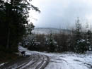
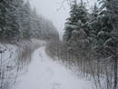
I was rapidly closing in on the cloud level. The summit was somewhere above me but I could not see anything but clouds. At about 7 miles there is a major intersection. All previous turns had red arrows pointing the way. This one pointed right. I knew that the road straight ahead went to the summit. I didn't know if the other one did as well. I was making good time so I decided to do some exploring. The road to the right quickly climbed to the ridge top. Instead of following the ridge to the summit it dropped down the opposite side. What the heck, I decided to keep following the road. It dropped then leveled off. It had a number of ups and downs as it contoured around the mountain. I still held out hope that it would intersect the Rattlesnake Mountain Trail just below the summit. On and on I went until the road made one final drop. At the bottom was...the end of the road. It was a giant clearcut turn around. With the clouds I had no idea where I was. I had no desire to clamber up the steep hillside looking for the summit and so I turned around.
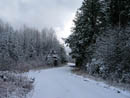
It had taken me nearly 40 minutes on the detour so I figured I was already 9 miles into the trip. For a brief several minutes a sucker hole opened and I had sunshine. I took advantage to take a number of nice photos. 35 minutes later I was back at the intersection. Common sense told me that 18 miles is long enough. There also was not likely to be much if any views from the top. Still I was only a mile away... I turned right and headed on up. When the towers came into view the upper parts were invisible. Only the bottoms could be seen through the clouds. I met up with the Rattlesnake Mountain Trail just below Grand Prospect. There were multiple footprints in the snow. I was not the first person there this day.
At Grand Prospect I had a better view than expected. Most of Mt. Si was open. The summit and all the other peaks were clouded in. It was below freezing here and I bundled up. After a short break I was back on the road by 1:25. Soon it began to snow lightly. I haven't seen much of that this year. At about the 6 mile mark a couple bikers came up the road. They were slogging through several inches of snow. I can walk 20 miles but I would hate to bike up that much elevation in snow. It was warming quickly at lower elevations. By the 4 mile mark the road was largely bare. That bright white coating of snow had melted in just a few hours. After 16 miles I just ground out the last 4. A solo biker went by then the couple I saw high on the mountain zoomed by me. At 3:50 I finally reached the car. I covered 20 miles gaining 3000' in 6:09.
This is primarily a mountain biking area and for good reason. You can gain a lot of elevation and/or do many miles. When the conditions are just right it can be a fun spot to hike. With the fresh snow this was a great day for a long hike.
Click on thumbnails to get larger pictures.
Photo Page 2
Trips - 2005
Home
At 2 1/2 miles the road begins to climb. Soon after that a bicyclist passed me. With the steep road and the snow he slowed down and I was able to catch up. There is no way I could have biked up that road. At the top of the hill he went left and I stayed right. I reached the 4 mile marker in 63 minutes. The route gained only 800' to there. For the first 3 1/2 miles there were tire tracks in the fresh snow. From there on the snow was untouched. The needed left turn at 4 3/4 miles was gated. I turned there and began to climb. The snow was now a few inches deep and the trees were completely flocked. The snow created a cushion underfoot making the hard road very easy to walk.
I was rapidly closing in on the cloud level. The summit was somewhere above me but I could not see anything but clouds. At about 7 miles there is a major intersection. All previous turns had red arrows pointing the way. This one pointed right. I knew that the road straight ahead went to the summit. I didn't know if the other one did as well. I was making good time so I decided to do some exploring. The road to the right quickly climbed to the ridge top. Instead of following the ridge to the summit it dropped down the opposite side. What the heck, I decided to keep following the road. It dropped then leveled off. It had a number of ups and downs as it contoured around the mountain. I still held out hope that it would intersect the Rattlesnake Mountain Trail just below the summit. On and on I went until the road made one final drop. At the bottom was...the end of the road. It was a giant clearcut turn around. With the clouds I had no idea where I was. I had no desire to clamber up the steep hillside looking for the summit and so I turned around.
It had taken me nearly 40 minutes on the detour so I figured I was already 9 miles into the trip. For a brief several minutes a sucker hole opened and I had sunshine. I took advantage to take a number of nice photos. 35 minutes later I was back at the intersection. Common sense told me that 18 miles is long enough. There also was not likely to be much if any views from the top. Still I was only a mile away... I turned right and headed on up. When the towers came into view the upper parts were invisible. Only the bottoms could be seen through the clouds. I met up with the Rattlesnake Mountain Trail just below Grand Prospect. There were multiple footprints in the snow. I was not the first person there this day.
At Grand Prospect I had a better view than expected. Most of Mt. Si was open. The summit and all the other peaks were clouded in. It was below freezing here and I bundled up. After a short break I was back on the road by 1:25. Soon it began to snow lightly. I haven't seen much of that this year. At about the 6 mile mark a couple bikers came up the road. They were slogging through several inches of snow. I can walk 20 miles but I would hate to bike up that much elevation in snow. It was warming quickly at lower elevations. By the 4 mile mark the road was largely bare. That bright white coating of snow had melted in just a few hours. After 16 miles I just ground out the last 4. A solo biker went by then the couple I saw high on the mountain zoomed by me. At 3:50 I finally reached the car. I covered 20 miles gaining 3000' in 6:09.
This is primarily a mountain biking area and for good reason. You can gain a lot of elevation and/or do many miles. When the conditions are just right it can be a fun spot to hike. With the fresh snow this was a great day for a long hike.
The Start |
Bare Road |
Cyclist |
Untracked Snow |
Snowy Trees |
Beyond The Gate |
Flocked Trees |
Detour Route |
In The Clouds |
Sunshine |
Photo Page 2
Trips - 2005
Home