01-29-06
The weather forecast was for more snow and rain. Avalanche
danger was high most everywhere. The morning brought a lull in the deluge
but it was coming back later in the day. With all that in mind, Bob, Kolleen,
and I headed east with several possibilities in mind. We ruled out Mt.
Teneriffe, Granite Lakes, and Humpback Mt. and settled on Dirty Harry's
Peak. I had done it once, back in 1986, and they had done it without snow
last year. We left the highway at exit 38 and drove on to the trailhead beyond
the open gate. The gate is signed as closing at 4:00 pm so that was our
only time constraint. There was no rain in sight as we headed up the trail
just before 8:30 am.
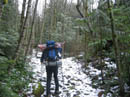
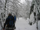
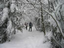
Lower down, the route is an old road which this day was more of a creek. The trailhead is at about 1350' and the summit is 4650'. The snow level was rising and I just wanted to get above the rain before the inevitable precipitation began. After gaining about 400' the snow began. At first it was just a dusting but it soon began to deepen. By the time we reached the unsigned turnoff for Dirty Harry's Balcony the snow was covering the trail with at least a few inches. The snow was very soft and we postholed to the ground even as the snow grew deeper.
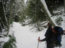
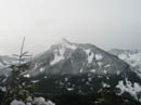
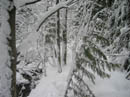
By the time we were sinking in 6 inches with every step it was time to don snowshoes. Soon after we had the only view out and could see across the valley to McClellan Butte. The route soon reached a roaring creek and the way was not obvious under the snow. We followed along the side of the creek, crossed a smaller creek and the road was again apparent. We then began to encounter two problems. In places the road reverted to a creek with no way to walk around it. We had to either take off and put on our snowshoes numerous times or plod ahead up the rocky road. We did the latter. The other problem was the small deciduous trees which now grow along the old road bed. They bend easily under a heavy snow load. We had many small trees which required knocking off the snow and pushing them back upright. It was quite an arm workout.
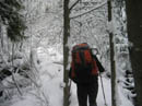
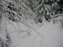
The deeper snow and the bent over blocking trees made for slow going. At one point the snow suddenly grew much deeper. In a very short distance it went from easy walking to deep sinking. I sank about 6 inches with every step when in the lead. When I was last there 20 years ago their were many open views. The forest has grown a great deal since then and the views are gone. On the positive side the freeway noise is now muted and the avalanche danger is about zero. Bob and Kolleen stopped for a clothing break and I took the lead. The route switchbacked to the right and it got ugly.
There was a landslide or a berm or I don't know what but the route seemed to go up very steeply. The snow was so deep that I could not cut a trail. I meandered back and forth until I fell into a mega deep hole. It was more shoulder deep than waist deep and I'm 6'4". By now Bob caught up and wallowed ahead through the morass. The next section was the worst for bent over trees. It was a struggle to pull them up enough to get under them. In places we were down to a creek in the trail with low branches. The only option was to crawl in the water a short bit.
At the next switchback things began to improve. We found much less of the deciduous blockade and some flat open snow to walk in. Near the switchback we passed under the bottom of a talus field with surprisingly little snow on it. I believe this is the point to go cross country to West Defiance Peak. Part way up this section we stopped for food. It was past 11:30 and we had been going nearly non stop for 3 hours. We still had over 1200' to gain. We had one more rocky creek in the trail to clank up and a last tree barricade then the only problem was rapidly deepening snow.
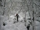
The next switchback was fun as it too was extra deep and it must have taken 5 minutes to make 50 feet of progress. The road had a few steeper stretches which were heartening as we just wanted to gain elevation as fast as possible. In the lead I now sank to my knees or worse on every step. Three people was the minimum to have been able to make it to the top. One more person would sure have been welcome. We came to a "Y" in the road. Due to our last second choice of this trip we did not have a map. A wrong choice here and we would not have had the energy to drop back down and try the other. Bob felt that the left road was correct and we went along.
The road was now very narrow and getting to be more of a trail. It widened again and we felt better about the choice to go left. The last 300' was a slow matter of gutting it out. Step, sink, and repeat. Bob and I are big guys and we still sank, even in Kolleen's footprints. The third person in line did have it very easy. For the first time the wind was beginning to howl. With the wind and the clouds blocking all views it was clear that our summit stay would be short.
We finally ran out of mountain. I have been turned around short of the summit by deep snow on an awful lot of trips this winter so just reaching a summit was a good feeling. It took us total of 4:15 to cover the 5 1/2 miles. For a comparison, Bob and Kolleen did it in 2 hours flat last May. Five feet of soft snow has a way of slowing you down. It was now 12:45 leaving us 3:15 to get down before the gate was scheduled to be closed. Not a problem.
Descending in our nice deep trench was a blast. It was nice to move fast after the glacial pace on the way up. A few times I lost my balance and pushed down hard on my pole only to see it sink in as much as four feet. That's with snow baskets. The trip down was great as we followed the trench. It began to snow three quarters of the way up and continued all the way down. Thankfully, the precipitation did not turn to rain until we were within less than half an hour of the car. Our time down was 2 hours. The whole drive home was in pouring rain.
This turned out to be a fun trip. There was zero avalanche danger on a day when most of the mountains were very dangerous. The clear morning kept us out of rain on the way up. It was one heck of a workout. Lastly, the company was excellent. This is a good snowshoe trip when you don't want to drive a long way. Now I'm interested in seeing what it looks like without all the snow.
Click on thumbnails to get larger pictures.
Photo Page 2
Trips - 2006
Home
Lower down, the route is an old road which this day was more of a creek. The trailhead is at about 1350' and the summit is 4650'. The snow level was rising and I just wanted to get above the rain before the inevitable precipitation began. After gaining about 400' the snow began. At first it was just a dusting but it soon began to deepen. By the time we reached the unsigned turnoff for Dirty Harry's Balcony the snow was covering the trail with at least a few inches. The snow was very soft and we postholed to the ground even as the snow grew deeper.
By the time we were sinking in 6 inches with every step it was time to don snowshoes. Soon after we had the only view out and could see across the valley to McClellan Butte. The route soon reached a roaring creek and the way was not obvious under the snow. We followed along the side of the creek, crossed a smaller creek and the road was again apparent. We then began to encounter two problems. In places the road reverted to a creek with no way to walk around it. We had to either take off and put on our snowshoes numerous times or plod ahead up the rocky road. We did the latter. The other problem was the small deciduous trees which now grow along the old road bed. They bend easily under a heavy snow load. We had many small trees which required knocking off the snow and pushing them back upright. It was quite an arm workout.
The deeper snow and the bent over blocking trees made for slow going. At one point the snow suddenly grew much deeper. In a very short distance it went from easy walking to deep sinking. I sank about 6 inches with every step when in the lead. When I was last there 20 years ago their were many open views. The forest has grown a great deal since then and the views are gone. On the positive side the freeway noise is now muted and the avalanche danger is about zero. Bob and Kolleen stopped for a clothing break and I took the lead. The route switchbacked to the right and it got ugly.
There was a landslide or a berm or I don't know what but the route seemed to go up very steeply. The snow was so deep that I could not cut a trail. I meandered back and forth until I fell into a mega deep hole. It was more shoulder deep than waist deep and I'm 6'4". By now Bob caught up and wallowed ahead through the morass. The next section was the worst for bent over trees. It was a struggle to pull them up enough to get under them. In places we were down to a creek in the trail with low branches. The only option was to crawl in the water a short bit.
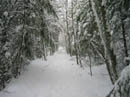
At the next switchback things began to improve. We found much less of the deciduous blockade and some flat open snow to walk in. Near the switchback we passed under the bottom of a talus field with surprisingly little snow on it. I believe this is the point to go cross country to West Defiance Peak. Part way up this section we stopped for food. It was past 11:30 and we had been going nearly non stop for 3 hours. We still had over 1200' to gain. We had one more rocky creek in the trail to clank up and a last tree barricade then the only problem was rapidly deepening snow.
The next switchback was fun as it too was extra deep and it must have taken 5 minutes to make 50 feet of progress. The road had a few steeper stretches which were heartening as we just wanted to gain elevation as fast as possible. In the lead I now sank to my knees or worse on every step. Three people was the minimum to have been able to make it to the top. One more person would sure have been welcome. We came to a "Y" in the road. Due to our last second choice of this trip we did not have a map. A wrong choice here and we would not have had the energy to drop back down and try the other. Bob felt that the left road was correct and we went along.
The road was now very narrow and getting to be more of a trail. It widened again and we felt better about the choice to go left. The last 300' was a slow matter of gutting it out. Step, sink, and repeat. Bob and I are big guys and we still sank, even in Kolleen's footprints. The third person in line did have it very easy. For the first time the wind was beginning to howl. With the wind and the clouds blocking all views it was clear that our summit stay would be short.
We finally ran out of mountain. I have been turned around short of the summit by deep snow on an awful lot of trips this winter so just reaching a summit was a good feeling. It took us total of 4:15 to cover the 5 1/2 miles. For a comparison, Bob and Kolleen did it in 2 hours flat last May. Five feet of soft snow has a way of slowing you down. It was now 12:45 leaving us 3:15 to get down before the gate was scheduled to be closed. Not a problem.
Descending in our nice deep trench was a blast. It was nice to move fast after the glacial pace on the way up. A few times I lost my balance and pushed down hard on my pole only to see it sink in as much as four feet. That's with snow baskets. The trip down was great as we followed the trench. It began to snow three quarters of the way up and continued all the way down. Thankfully, the precipitation did not turn to rain until we were within less than half an hour of the car. Our time down was 2 hours. The whole drive home was in pouring rain.
This turned out to be a fun trip. There was zero avalanche danger on a day when most of the mountains were very dangerous. The clear morning kept us out of rain on the way up. It was one heck of a workout. Lastly, the company was excellent. This is a good snowshoe trip when you don't want to drive a long way. Now I'm interested in seeing what it looks like without all the snow.
First Snow |
Solid Snow Cover |
McClellan Butte |
Dirty Harry's Road |
Snow Plastered |
Trees On The Road |
More Trees |
Kolleen Ahead |
Lots Of Snow |
Trail? |
Photo Page 2
Trips - 2006
Home