4-02-06
Our original plan was to snowshoe up Snoqualmie Mountain.
The previous day's avalanche forecast called for low danger below 4000' and
moderate above. It also called for light snow at Snoqualmie Pass but 3"
fell there and 7" at Stevens. At over 6000' the amount on Snoqualmie Mountain
was an unknown. Add in a report of slide at Granite Mountain two days previous
and we made a last minute change. Bob and Kolleen met Suzanne and I at the
Alpental lot. We switched our destination to Guye Peak via Commonwealth
Basin. That route I knew and any danger would be much less. It was the first
day of daylight saving time and just getting up to the pass at 8:30 am was
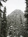
a chore (7:30 body time). By about 9:00 we were on our way. The summit was
visible from the lot but partly in the clouds.
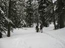
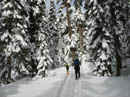
The main snowshoe trench went up to the upper parking lot of the Pacific Crest Trail. I wanted to get a shot of the deeply buried outhouse in the main lot so we detoured over there. It was buried almost up to the roof top. A short way up the trail we turned off on the old Crest Trail heading for Commonwealth Basin. The snowshoe track was not as well packed as the one heading to the upper parking lot but it was hard enough for us to keep our snowshoes packed.
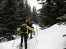
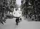
It followed the old road bed a ways and then turned up the hill. The going was still very easy although we postholed a little. As the grade steepened we stopped to put on snowshoes. Soon after we met up with the main track once again. It would probably been easier without snowshoes but we already had them on and did not want to stop again. We had one peek a boo view up to the summit of Guye Peak along here. The grade eased as we entered the basin and shortly we came to the crossing of Commonwealth Creek.
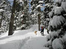
A path continued on the right side of the creek but we chose to cross here. The snow bank is about 10 feet requiring a quick drop to the creek. The creek is wide at this point and not deep. A steep climb back up the other side and we were back on our way. The route continued up the left side of the valley. It is flat at first then gains some minimal elevation. We hiked past Guye and when below the low pass on the ridge above we crossed another creek on a snow bridge. From here it is all uphill to the ridge top.
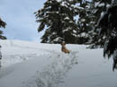
I was not surprised to see a deep track in the basin. I was very surprised to see numerous footprints heading up towards Guye. These were footprints not snowshoe prints. They were hard and deep enough to make it difficult to snowshoe on them. I walked to the side where possible though I then sank into the snow. The chopped up footprints slowed us down but we made consistent progress up the slope. In due time we topped out on the ridge top.
I had done Guye once before in the summer via this route and part way in the winter though blizzard conditions sent us back just before the ridge top. None of us had been up the ridge on snow. At the top of the ridge footprints went in a number of directions. A trench headed right, another headed down towards the Alpental route, and one more headed left up the ridge of Guye. We headed left.
A short quick climb brought us to a small plateau where I recalled there was a tarn in the summer. It was deep under snow now. Behind it the footprints headed steeply uphill. The hillside was full of footprints and snowshoes were not the best choice here. When the grade flattened we saw where all the footprints had come from. A BoeAlps climbing course group was booting it up the slope. It seems that the group had split up into smaller groups on different peaks and these were the Guye students.
We had come this far with snowshoes and poles while they had helmets, ropes, and ice axes in hand. We seemed a little under dressed by comparison. We let them get ahead and took time for a snack. We also decided to leave our snowshoes here and make use of the boot steps being put in above us. Ice axes came out and we set to tackle the last 300'. The snow was good for steps and although the route was steep at first it was easy going. If it were icy I would not have gone on. We reached the top to find some students at their first ever summit. Although it is not a high peak the summit is a little airy.
We topped out at about 11:45 making it about 2:45 to the top. Not blazing speed for only a 3 mile hike but still a very pleasant morning. Clouds were all around us. One minute we could see Snoqualmie Mountain and the next it was lost in the clouds. Red and Kendall never come into view although we could see Red Pass and where Red Pond is located. The wind was blowing here and with the crowd of climbers we made our summit stay a short one.
It didn't take long to reach our snowshoes and this proved to be a good protected spot for lunch. Snowshoes went back on our packs for the descent. Rather than the hard and slick steps I ran down the ridge in fresh snow. It was between knee and crotch deep with every step. Even with the sinking I was able to run down to the tarn in just a few minutes. The descent to the basin was fast though punctuated by occasional unexpected postholes to the waist or more. It was almost comical as we would suddenly sink down to the height of Sadie the Golden Retriever. With 4 paw drive she had less trouble than the rest of us.
We did see a group of skiers who were heading up the ridge. They had two tiny dogs with legs only inches long. I don't know how they made it so far with those legs. Down in the basin it was obviously above freezing now. The snow laden trees were raining on us as the snow melted. It was lightly snowing when we started but it never seemed cold. That is with the exception of the wind on the very summit. We followed our trail but this time we stayed on the main track through the upper parking lot. The snowshoes never did go back on. We crossed back under the highway and deducting for our lunch stop it took about 1:35 from the summit to the car. Not bad for a snow descent.
This proved to be an excellent choice. The hike into the basin was easy with the snowshoe trench in place. The ridge climb was all in trees with minimal avalanche danger. The final ridge was steep enough to be fun without being dangerous. The summit may be directly above a major interstate highway but it feels high and airy. I'll have to make a return winter trip on a sunny day to see the rest of the views we missed this day.
Click on thumbnails to get larger pictures.
Photo Page 2
Trips - 2006
Home
The main snowshoe trench went up to the upper parking lot of the Pacific Crest Trail. I wanted to get a shot of the deeply buried outhouse in the main lot so we detoured over there. It was buried almost up to the roof top. A short way up the trail we turned off on the old Crest Trail heading for Commonwealth Basin. The snowshoe track was not as well packed as the one heading to the upper parking lot but it was hard enough for us to keep our snowshoes packed.
It followed the old road bed a ways and then turned up the hill. The going was still very easy although we postholed a little. As the grade steepened we stopped to put on snowshoes. Soon after we met up with the main track once again. It would probably been easier without snowshoes but we already had them on and did not want to stop again. We had one peek a boo view up to the summit of Guye Peak along here. The grade eased as we entered the basin and shortly we came to the crossing of Commonwealth Creek.
A path continued on the right side of the creek but we chose to cross here. The snow bank is about 10 feet requiring a quick drop to the creek. The creek is wide at this point and not deep. A steep climb back up the other side and we were back on our way. The route continued up the left side of the valley. It is flat at first then gains some minimal elevation. We hiked past Guye and when below the low pass on the ridge above we crossed another creek on a snow bridge. From here it is all uphill to the ridge top.
I was not surprised to see a deep track in the basin. I was very surprised to see numerous footprints heading up towards Guye. These were footprints not snowshoe prints. They were hard and deep enough to make it difficult to snowshoe on them. I walked to the side where possible though I then sank into the snow. The chopped up footprints slowed us down but we made consistent progress up the slope. In due time we topped out on the ridge top.
I had done Guye once before in the summer via this route and part way in the winter though blizzard conditions sent us back just before the ridge top. None of us had been up the ridge on snow. At the top of the ridge footprints went in a number of directions. A trench headed right, another headed down towards the Alpental route, and one more headed left up the ridge of Guye. We headed left.
A short quick climb brought us to a small plateau where I recalled there was a tarn in the summer. It was deep under snow now. Behind it the footprints headed steeply uphill. The hillside was full of footprints and snowshoes were not the best choice here. When the grade flattened we saw where all the footprints had come from. A BoeAlps climbing course group was booting it up the slope. It seems that the group had split up into smaller groups on different peaks and these were the Guye students.
We had come this far with snowshoes and poles while they had helmets, ropes, and ice axes in hand. We seemed a little under dressed by comparison. We let them get ahead and took time for a snack. We also decided to leave our snowshoes here and make use of the boot steps being put in above us. Ice axes came out and we set to tackle the last 300'. The snow was good for steps and although the route was steep at first it was easy going. If it were icy I would not have gone on. We reached the top to find some students at their first ever summit. Although it is not a high peak the summit is a little airy.
We topped out at about 11:45 making it about 2:45 to the top. Not blazing speed for only a 3 mile hike but still a very pleasant morning. Clouds were all around us. One minute we could see Snoqualmie Mountain and the next it was lost in the clouds. Red and Kendall never come into view although we could see Red Pass and where Red Pond is located. The wind was blowing here and with the crowd of climbers we made our summit stay a short one.
It didn't take long to reach our snowshoes and this proved to be a good protected spot for lunch. Snowshoes went back on our packs for the descent. Rather than the hard and slick steps I ran down the ridge in fresh snow. It was between knee and crotch deep with every step. Even with the sinking I was able to run down to the tarn in just a few minutes. The descent to the basin was fast though punctuated by occasional unexpected postholes to the waist or more. It was almost comical as we would suddenly sink down to the height of Sadie the Golden Retriever. With 4 paw drive she had less trouble than the rest of us.
We did see a group of skiers who were heading up the ridge. They had two tiny dogs with legs only inches long. I don't know how they made it so far with those legs. Down in the basin it was obviously above freezing now. The snow laden trees were raining on us as the snow melted. It was lightly snowing when we started but it never seemed cold. That is with the exception of the wind on the very summit. We followed our trail but this time we stayed on the main track through the upper parking lot. The snowshoes never did go back on. We crossed back under the highway and deducting for our lunch stop it took about 1:35 from the summit to the car. Not bad for a snow descent.
This proved to be an excellent choice. The hike into the basin was easy with the snowshoe trench in place. The ridge climb was all in trees with minimal avalanche danger. The final ridge was steep enough to be fun without being dangerous. The summit may be directly above a major interstate highway but it feels high and airy. I'll have to make a return winter trip on a sunny day to see the rest of the views we missed this day.
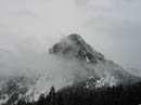
Guye Peak |
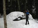
Buried Outhouse |
Old Crest Trail |
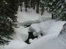
Commonwealth Creek |
Guye Peak 2 |
Commonwealth Basin |
Beginning Ascent |
Shadows |
Dual Tracks |
Waiting Patiently |
Photo Page 2
Trips - 2006
Home