8/19-20/06
Snowking is a scramble I have been looking forward
to for a few years. I knew it was steep. That turned out to be an understatement.
Gary, Kolleen, and Bob joined me for this trip. The views are so outstanding
and the effort so high I would not do this hike without nearly perfect weather.
That is exactly what we had. Gary and I met Kolleen and Bob at the turn off
located just after the 14 mile marker on the Cascade River Road out of Marblemount.
The road drops to a crossing of the Cascade River followed by a right turn.
It is 2.7 miles total to the roughly 1500' road end. There are a number
of deep drain dips which with some care we crossed with Gary's Toyota Corolla.
There was one car at the end of the road. It was parked such that turning around was difficult. There is not much room at the end. Bob and Kolleen returned to a larger space less than .20 miles away. When we returned there were 3 cars in this space. Gary spied an overgrown pullout and he backed and filled smashing brush to created a new space for 2 cars. We were packed up and ready to go by a little before 9:00 am.
As stated in other reports, there is a huge log angled down and across the road with a deep washout right after it. We said hello to the two young women who had camped at the trailhead and were getting ready to hit the trail. The old road proceeds uphill at a gentle grade. It reaches a "Y" where you go left. The road crossed the washout creek bed on a bridge, switches back and dead ends where the "trail" begins. It took us 50 minutes to reach this point at about 2400'. I would guess it to be about 2 1/4 miles.
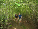
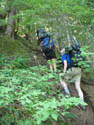
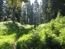
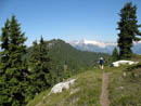
The clearcut mentioned in guidebooks is returning to forest. The trees are mostly 10-20 feet tall. The first part in the old clearcut is very brushy. The route begins very steep and stays that way for some 1600 vertical feet. It goes more or less straight up the steep hillside. This is tough going up but even worse coming down. Poles are recommended. Somewhere near 4000' the grade eases. We passed a bog where the obvious route goes straight towards what may be a camp site. The real route crosses a muddy bog and the trail soon becomes obvious again. There is actually a short nearly level stretch through meadow along here.
The route climbs below Point 5116 to near 5000' before descending to a pass at 4700'. Here there is a trail blocked off by logs. This goes down to Found Lake. 17 years earlier Gary had backpacked to Found Lake and then followed the ridge part way up towards the summit of Snowking. The open trail leaves the wooded saddle and begins to climb steeply once again. Now came the steep climb up over 1000' to the top of Point 5791. As with most of the route you can forget about switchbacks. Forest now gives way to some heather. The route usually goes straight up the heather.
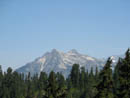
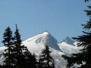
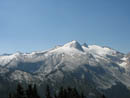
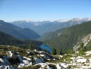
It was fairly cool in the forest but as we broke out partly in the open it was hot. We encountered large granite blocks through here. At the top of Point 5791 we stopped for lunch. We now had great views out including Snowking on one side and Eldorado and Sahale on the other. Found Lake was a bright greenish blue as was Snowking Lake. We could also see a part of a small lake which was our destination for camp. To get there we still had a steep drop and another climb to make.
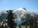
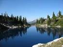
After lunch we headed down. The first part is a little tricky as the route dives between small trees and has large granite steps down. Soon the route becomes it's steep narrow obvious self again. We dropped down to a saddle at about 5250' then climbed up to near the top of Point 5695. We had a short drop to a saddle then dropped straight down towards two small lakes. We now had a very nice view of Cyclone Lake sitting below Snowking Mountain. We missed a side trail to the right most lake and dropped to the other. We had to boulder hop around and up to the bench between the lakes.
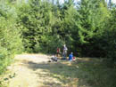
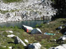
A little scouting here provided two nice campsites for us. Bob and Kolleen took the upper and Gary and I the lower. What a neat spot to camp! We had water close by and terrific views from camp. The lake next to us is at 5442'. It was a hot afternoon and we now encountered some bothersome mosquitos. We had earlier elected to climb Snowking Sunday morning so we had the rest of the day free to relax and explore the rock and heather around our site. A 200' climb to the top of the ridge provided nice views out to peaks in most directions.
This was my second trip with my Tarptent Rainbow and a chance to see Bob and Kolleen's new Tarptent Double Rainbow. With the vestibules open we both had minimal condensation next to the lake, in the open, with no wind. Before sunset we clambered back up the hill for some late night photos. We set our alarms for 5:30 and went to bed.
DAY 2
We were awake by 5:30, had breakfast, and packed up for the summit. We were detoured by photo opportunities of Snowking and Cyclone Lake in the early morning light. It was 6:45 by the time we hit the trail. To be safe we brought ice axes and crampons. First we climbed back up to the saddle and followed the boot path to near the top of Point 5860. From there we descended to a meadow and boulder saddle at about 5550'. We saw a lone hiker high above us on the ridge. Now the fun began. The ridge began to climb and so did we on heather and some rock. We stayed on the left side of the ridge top at first.
Higher up we went to the top of the ridge. Views expanded with elevation gained. The morning was crystal clear with no clouds or haze. By 7:30 am it was getting warm. The granite is extremely sticky and we traversed some quite steep slabs with comfort. We stopped for a sunscreen break at the first snow patch. Bob jumped onto it and it proved to be hard as rock. The two women we had seen at the trailhead passed us here. Ahead of us were a number of long snow patches interspersed with the granite slabs. Climbing above or below them would be difficult.
We took some time to scope out a route. We could pull out crampons but after each short snow patch was more granite slabs. I prefer vibram on the slabs. The women climbed up towards the ridge top but soon returned with a thumbs down verdict. They crossed the snow above us and we scrambled up towards that point. If the snow were softer it would have been easy. With ice axes out we crossed the hard snow to more granite. Each snow patch ahead had had more sun and was easier to cross. Soon we were around the bad section and back on the ridge crest.
We went to the left side of the ridge and picked up a nice path in heather again. We could now see two people on the summit some 900' above us. When the heather gave way to a boulder moraine we chose to descend to the upper glacier (snowfield) below. The snow was hard but perfect for cramponing. Climbing up the snow was much easier than the rock. We could see a small notch to the left of the summit block. As we approached, the two women appeared in the notch. We considered climbing to the notch on ice but there was a crevasse open and it did not seem worth the risk. Instead we exited the snow to the left of the notch.
I climbed up to the top of the rubble heap ridge and headed towards the notch. I cut around the left side and made it to within about a six foot step. Unfortunately if a jump dd not succeed it was a long fall down the back side of the notch. I could now see the first two guys as they were sliding down snow below the notch. I headed back and found the others on snow at the steep hard snow below the notch. There was a moat as well to get around. Bob went right and dropped into the moat. I went left and did likewise. Bob climbed up loose rock and dirt the 15' or so to the notch. I chose to climb rock part way then the dirt to the top. The other followed.
When I was on the ridge top across the notch I had a look at the final scramble and it looked to be absolutely vertical. I sadly determined that this summit was likely not for me. At the notch it did not look that bad. Bad but not that bad. Bob went first and the scramble route picked it's way on up. Hand holds were good as well. With much less trouble than I expected we were soon on the summit. And what a summit! The views in every direction are absolutely stunning.
Found, Skaro, Neori, Snowking, Cyclone, and our two camp lakes were laid out below. Baker and Shuksan were north. Three Fingers and Whitehorse seemed too close. Sloan, Pugh, and Whitehorse were in a row. Glacier Peak rose high. Mt. Rainier seemed a long way away. We could see Stuart, Daniel, Dome, and many more peaks. Straight below the back side of the notch was a blue bowl of a lake with a brownish glaciated lake just below it. It looked like the lake was only recently forming from the melting glacier.
Another climber caught up with us as we left the notch so there were 7 of us on the summit. With a nice cool breeze it was the first bug free place we had seen is quite some time. I would have liked to have spent a few hours on top but we had a long way to go getting out so we limited it to about 40 minutes. The women left first then the solo climber. At 10:30 we headed down. Descending is always harder than climbing but the summit block proved to be no problem for any of us. That 15+ foot drop on loose crud to the bottom of the notch did not look inviting. In fact, we saw the other two groups climb up onto the ridge on the other side. We chose to do likewise.
While the spot on the side I had reached earlier was not a way up, straight up the face was. There was one nice rock step and an easy climb to the top. From there we down climbed the boulder ridge to the snow. The snow had softened considerably in the previous hour. It was now fine to descend in boots. We managed two nice glissades and easy snow walking until we climbed back onto the rock. We followed our route back to where we had problems on the way up.
Now the snow was much softer and we had no problems crossing the patches. We headed lower and Bob chose a route that kept us on easy enough slabs that we had no more problems. A snow ramp brought us back up to where we had first encountered snow in the morning. From here it was a fun granite and heather descent to the first saddle. A climb back to near Point 5860 and a final descent to camp. With our route finding problems with the icy snow it took us 3:07 to ascend and about 2:15 to come down. We did spent lots of time taking photos as well.
It was getting really hot as we broke camp. We climbed back up to the ridge top where we met the solo climber and his companion. They soon passed us not to be seen again until the trailhead. The climb back up to Point 5791 in the hot sun was hard. The knee pounding the next 4300 vertical feet was even worse. From the summit we dropped a little over 7000' that day. It will be a day or two before my knees stop complaining and I don't usually get knee pain. The rest of the way out was just a grind. At the top of the steep 1600' climb we met a party that did not look to be in shape for the lakes let alone the summit. I hope they had a good time and made it out safely. I need to emphasize that at this time there is virtually no water from the start to the lakes. Only a few small stagnant ponds. I would have to be desperate to drink from them after filtering.
By about 6:00 we crossed the washout and reached the start. It was a spectacular weekend. Lots of pain but even more enjoyment. The lakes are nice and the summit scramble even better. We could not have asked for better weather. We saw three other parties the first day and a half plus two more parties coming up as we descended. All the parties camped well away and out of sight from each other. I'm a little in awe of those who do this as a day hike. We needed both days and a third would have been nice for some exploring and an early morning descent. Great company and a great destination. With side wandering I figure about 17 miles with 9000' of gain.
Click on thumbnails to get larger pictures.
Photo Page 2
Trips - 2006
Home
There was one car at the end of the road. It was parked such that turning around was difficult. There is not much room at the end. Bob and Kolleen returned to a larger space less than .20 miles away. When we returned there were 3 cars in this space. Gary spied an overgrown pullout and he backed and filled smashing brush to created a new space for 2 cars. We were packed up and ready to go by a little before 9:00 am.
As stated in other reports, there is a huge log angled down and across the road with a deep washout right after it. We said hello to the two young women who had camped at the trailhead and were getting ready to hit the trail. The old road proceeds uphill at a gentle grade. It reaches a "Y" where you go left. The road crossed the washout creek bed on a bridge, switches back and dead ends where the "trail" begins. It took us 50 minutes to reach this point at about 2400'. I would guess it to be about 2 1/4 miles.
The clearcut mentioned in guidebooks is returning to forest. The trees are mostly 10-20 feet tall. The first part in the old clearcut is very brushy. The route begins very steep and stays that way for some 1600 vertical feet. It goes more or less straight up the steep hillside. This is tough going up but even worse coming down. Poles are recommended. Somewhere near 4000' the grade eases. We passed a bog where the obvious route goes straight towards what may be a camp site. The real route crosses a muddy bog and the trail soon becomes obvious again. There is actually a short nearly level stretch through meadow along here.
The route climbs below Point 5116 to near 5000' before descending to a pass at 4700'. Here there is a trail blocked off by logs. This goes down to Found Lake. 17 years earlier Gary had backpacked to Found Lake and then followed the ridge part way up towards the summit of Snowking. The open trail leaves the wooded saddle and begins to climb steeply once again. Now came the steep climb up over 1000' to the top of Point 5791. As with most of the route you can forget about switchbacks. Forest now gives way to some heather. The route usually goes straight up the heather.
It was fairly cool in the forest but as we broke out partly in the open it was hot. We encountered large granite blocks through here. At the top of Point 5791 we stopped for lunch. We now had great views out including Snowking on one side and Eldorado and Sahale on the other. Found Lake was a bright greenish blue as was Snowking Lake. We could also see a part of a small lake which was our destination for camp. To get there we still had a steep drop and another climb to make.
After lunch we headed down. The first part is a little tricky as the route dives between small trees and has large granite steps down. Soon the route becomes it's steep narrow obvious self again. We dropped down to a saddle at about 5250' then climbed up to near the top of Point 5695. We had a short drop to a saddle then dropped straight down towards two small lakes. We now had a very nice view of Cyclone Lake sitting below Snowking Mountain. We missed a side trail to the right most lake and dropped to the other. We had to boulder hop around and up to the bench between the lakes.
A little scouting here provided two nice campsites for us. Bob and Kolleen took the upper and Gary and I the lower. What a neat spot to camp! We had water close by and terrific views from camp. The lake next to us is at 5442'. It was a hot afternoon and we now encountered some bothersome mosquitos. We had earlier elected to climb Snowking Sunday morning so we had the rest of the day free to relax and explore the rock and heather around our site. A 200' climb to the top of the ridge provided nice views out to peaks in most directions.
This was my second trip with my Tarptent Rainbow and a chance to see Bob and Kolleen's new Tarptent Double Rainbow. With the vestibules open we both had minimal condensation next to the lake, in the open, with no wind. Before sunset we clambered back up the hill for some late night photos. We set our alarms for 5:30 and went to bed.
DAY 2
We were awake by 5:30, had breakfast, and packed up for the summit. We were detoured by photo opportunities of Snowking and Cyclone Lake in the early morning light. It was 6:45 by the time we hit the trail. To be safe we brought ice axes and crampons. First we climbed back up to the saddle and followed the boot path to near the top of Point 5860. From there we descended to a meadow and boulder saddle at about 5550'. We saw a lone hiker high above us on the ridge. Now the fun began. The ridge began to climb and so did we on heather and some rock. We stayed on the left side of the ridge top at first.
Higher up we went to the top of the ridge. Views expanded with elevation gained. The morning was crystal clear with no clouds or haze. By 7:30 am it was getting warm. The granite is extremely sticky and we traversed some quite steep slabs with comfort. We stopped for a sunscreen break at the first snow patch. Bob jumped onto it and it proved to be hard as rock. The two women we had seen at the trailhead passed us here. Ahead of us were a number of long snow patches interspersed with the granite slabs. Climbing above or below them would be difficult.
We took some time to scope out a route. We could pull out crampons but after each short snow patch was more granite slabs. I prefer vibram on the slabs. The women climbed up towards the ridge top but soon returned with a thumbs down verdict. They crossed the snow above us and we scrambled up towards that point. If the snow were softer it would have been easy. With ice axes out we crossed the hard snow to more granite. Each snow patch ahead had had more sun and was easier to cross. Soon we were around the bad section and back on the ridge crest.
We went to the left side of the ridge and picked up a nice path in heather again. We could now see two people on the summit some 900' above us. When the heather gave way to a boulder moraine we chose to descend to the upper glacier (snowfield) below. The snow was hard but perfect for cramponing. Climbing up the snow was much easier than the rock. We could see a small notch to the left of the summit block. As we approached, the two women appeared in the notch. We considered climbing to the notch on ice but there was a crevasse open and it did not seem worth the risk. Instead we exited the snow to the left of the notch.
I climbed up to the top of the rubble heap ridge and headed towards the notch. I cut around the left side and made it to within about a six foot step. Unfortunately if a jump dd not succeed it was a long fall down the back side of the notch. I could now see the first two guys as they were sliding down snow below the notch. I headed back and found the others on snow at the steep hard snow below the notch. There was a moat as well to get around. Bob went right and dropped into the moat. I went left and did likewise. Bob climbed up loose rock and dirt the 15' or so to the notch. I chose to climb rock part way then the dirt to the top. The other followed.
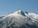
When I was on the ridge top across the notch I had a look at the final scramble and it looked to be absolutely vertical. I sadly determined that this summit was likely not for me. At the notch it did not look that bad. Bad but not that bad. Bob went first and the scramble route picked it's way on up. Hand holds were good as well. With much less trouble than I expected we were soon on the summit. And what a summit! The views in every direction are absolutely stunning.
Found, Skaro, Neori, Snowking, Cyclone, and our two camp lakes were laid out below. Baker and Shuksan were north. Three Fingers and Whitehorse seemed too close. Sloan, Pugh, and Whitehorse were in a row. Glacier Peak rose high. Mt. Rainier seemed a long way away. We could see Stuart, Daniel, Dome, and many more peaks. Straight below the back side of the notch was a blue bowl of a lake with a brownish glaciated lake just below it. It looked like the lake was only recently forming from the melting glacier.
Another climber caught up with us as we left the notch so there were 7 of us on the summit. With a nice cool breeze it was the first bug free place we had seen is quite some time. I would have liked to have spent a few hours on top but we had a long way to go getting out so we limited it to about 40 minutes. The women left first then the solo climber. At 10:30 we headed down. Descending is always harder than climbing but the summit block proved to be no problem for any of us. That 15+ foot drop on loose crud to the bottom of the notch did not look inviting. In fact, we saw the other two groups climb up onto the ridge on the other side. We chose to do likewise.
While the spot on the side I had reached earlier was not a way up, straight up the face was. There was one nice rock step and an easy climb to the top. From there we down climbed the boulder ridge to the snow. The snow had softened considerably in the previous hour. It was now fine to descend in boots. We managed two nice glissades and easy snow walking until we climbed back onto the rock. We followed our route back to where we had problems on the way up.
Now the snow was much softer and we had no problems crossing the patches. We headed lower and Bob chose a route that kept us on easy enough slabs that we had no more problems. A snow ramp brought us back up to where we had first encountered snow in the morning. From here it was a fun granite and heather descent to the first saddle. A climb back to near Point 5860 and a final descent to camp. With our route finding problems with the icy snow it took us 3:07 to ascend and about 2:15 to come down. We did spent lots of time taking photos as well.
It was getting really hot as we broke camp. We climbed back up to the ridge top where we met the solo climber and his companion. They soon passed us not to be seen again until the trailhead. The climb back up to Point 5791 in the hot sun was hard. The knee pounding the next 4300 vertical feet was even worse. From the summit we dropped a little over 7000' that day. It will be a day or two before my knees stop complaining and I don't usually get knee pain. The rest of the way out was just a grind. At the top of the steep 1600' climb we met a party that did not look to be in shape for the lakes let alone the summit. I hope they had a good time and made it out safely. I need to emphasize that at this time there is virtually no water from the start to the lakes. Only a few small stagnant ponds. I would have to be desperate to drink from them after filtering.
By about 6:00 we crossed the washout and reached the start. It was a spectacular weekend. Lots of pain but even more enjoyment. The lakes are nice and the summit scramble even better. We could not have asked for better weather. We saw three other parties the first day and a half plus two more parties coming up as we descended. All the parties camped well away and out of sight from each other. I'm a little in awe of those who do this as a day hike. We needed both days and a third would have been nice for some exploring and an early morning descent. Great company and a great destination. With side wandering I figure about 17 miles with 9000' of gain.
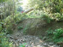
Washout |
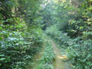
Road/Trail |
Roof? |
End Of The Road |
Getting Steeper |
Level Meadow |
Hidden Lake Peaks |
Snowking First Look |
Snowking Ridge |
Close Up |
Beyond 5791 |
Cyclone Lake |
Campsite |
Lake 5442 |
Found Lake |
Photo Page 2
Trips - 2006
Home