2-19-06
Cold clear weather was the perfect time to get away
from Seattle and go for a day of great views. Suzanne, Bob, and Kolleen
joined me for a trip up to the area north of Mt. Baker. We were still undecided
between Welcome Pass or snowshoeing from Mt. Baker ski area. We met at the
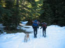
Glacier Ranger Station at around 8:00 am and decided on Welcome Pass. We
went past the road/trail and turned around at the maintenance sheds on the
left. It's about 1/3 mile back to the road. There is a plowed turnout on the
south side of the road where we parked. We were ready to get started just
before 9:00.
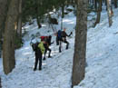
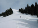
The actual trailhead is 8/10 mile up the road. There is a snow berm blocking the road. Snow on the road was only a few inches deep and hard so we kept our snowshoes on our packs. The winter start at the highway begins at roughly 2000'. Welcome Pass is at 5200'. The first 8/10 mile to the summer trailhead gains 450'. The next 2 1/4 miles to the pass gains 2750'. To state the obvious, it gets steep. There were deeply postholed steps in the snow lower down. Eventually all footprints went away.
From the summer trailhead the route continued at a moderate grade. We had a few last bare spots along the trail. It was in the mid 20s at the cars but it warmed rapidly as we climbed above the valley floor. By the trailhead it was already about 30 degrees. We were able to strip down for the rest of the climb to the pass. The snow deepened and became crusty. At times it would have been nice to have brought crampons. Still, with a little care we continued higher.
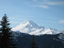
In the crustiest places my concern was whether we could find our route when descending. We were able to stay on the summer route most of the way up though it was sketchy at times. Kolleen and Bob did a great job of route finding. Rock hard stretches were sometimes followed by soft snow then back to the ice again. I did not realize that forest continues all the way to the pass. I kept waiting to come out of the forest and get a look up to the pass. It never happened. We had one view across to Mt. Baker but otherwise it was dark forest all the way up.
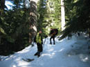
At our viewpoint we were not pleased to see high clouds drifting in. The morning was crystal clear and I thought the whole day would be like that. We would not have blue sky to offset all the snowy peaks but it didn't turn out so bad after all. My altimeter read 5200' and still we had forest above. Either the air pressure had changed or we were climbing above the pass. We tried angling to the left in hope of finding the pass. Finally we saw light above and a little more slogging in deeper snow brought us into the open.
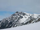
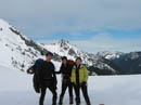
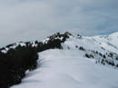
It turned out that we reached the ridge just to the right (east) of the pass. Now we had jaw dropping views of the peaks near the pass and to the north. Tomyhoi was not far away though it looked very different from this vantage point. It was now around noon and time for lunch. The three mile hike to the pass took us just over three hours. There are two high points on either side of the pass. Our next decision was to go east or west. Since we were already on the east side and above the pass, Point 5743 became our target.
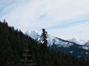
The ridge crest was a little crusty with snowmobile tracks running along it. The snow was deep enough for us to finally put on our snowshoes. Heck, after carrying them up 3300' it was time to put them to use. The ridge is much wider than I was expecting. In places it was at least 40' wide and also very flat. We started with a steeper section that took us above the trees and finally gave us views south. Mts. Baker and Shuksan were crystal clear though backed by white clouds now. The wind was almost non existent and it was still about 30 degrees.
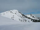
After the short steep climb the ridge turned to the north at a gentle grade. Now we could see northeast to Yellow Aster Butte, Mt. Larrabee, and the top of American Border Peak. We also had a nice close look at Goat Mountain . It looked much different from the fall hike I did there a few years back. We could see the east peak, the west peak, and the false summit where the trail ends. Point 5743 is really just a bump on the long flattish ridge. We continued to where the ridge drops off and had great 360 degree views. From there we could also see down into the Fraser River Valley in Canada.
It was now about 1:00 and time to head back. I love long ridge walks and this is one of the best winter ones I have done. I walked slow admiring the views. I was in no hurry to get back into the forest. I tried glissading the steep section but the few inches of soft snow under the crust would allow me to slide. In a few months there will be plenty of glissade opportunities. Back at our lunch spot we took off snowshoes and replaced one pole with ice axes.
The top section was snowy and plunge stepping worked great. Soon we were back into the icy crud and footing was a little more interesting. It did seem to have softened up a bit and that helped. All in all, the descent was not as bad as I feared. Nobody took a fall and where it was iciest and our boots left precious little marks we were able to stay on route. We dropped rapidly and were glad to be off the steep slope and back onto wide, albeit icy, trail. There was one stream crossing that was no problem and only a few downed trees which also presented no problems.
We finally popped out at the highway just before 3:30. We took a little over 3 hours to reach the ridge and a little under 2 hours to come down. While we did not get the bright blue skies forecast everything else was outstanding. After a winter in the Snoqualmie Pass area the North Cascades were a real treat. The ridge walk was among the best and the views from Pt. 5743 were well worth the effort. Quite a lot of effort it was. It took us about 2 1/2 hours driving time from Seattle to the trailhead. Great views, a challenging route with the ice, and great company made for a memorable day. I hope I have another trip this good this winter.
Click on thumbnails to get larger pictures.
Photo Page 2
Trips - 2006
Home
The actual trailhead is 8/10 mile up the road. There is a snow berm blocking the road. Snow on the road was only a few inches deep and hard so we kept our snowshoes on our packs. The winter start at the highway begins at roughly 2000'. Welcome Pass is at 5200'. The first 8/10 mile to the summer trailhead gains 450'. The next 2 1/4 miles to the pass gains 2750'. To state the obvious, it gets steep. There were deeply postholed steps in the snow lower down. Eventually all footprints went away.
From the summer trailhead the route continued at a moderate grade. We had a few last bare spots along the trail. It was in the mid 20s at the cars but it warmed rapidly as we climbed above the valley floor. By the trailhead it was already about 30 degrees. We were able to strip down for the rest of the climb to the pass. The snow deepened and became crusty. At times it would have been nice to have brought crampons. Still, with a little care we continued higher.
In the crustiest places my concern was whether we could find our route when descending. We were able to stay on the summer route most of the way up though it was sketchy at times. Kolleen and Bob did a great job of route finding. Rock hard stretches were sometimes followed by soft snow then back to the ice again. I did not realize that forest continues all the way to the pass. I kept waiting to come out of the forest and get a look up to the pass. It never happened. We had one view across to Mt. Baker but otherwise it was dark forest all the way up.
At our viewpoint we were not pleased to see high clouds drifting in. The morning was crystal clear and I thought the whole day would be like that. We would not have blue sky to offset all the snowy peaks but it didn't turn out so bad after all. My altimeter read 5200' and still we had forest above. Either the air pressure had changed or we were climbing above the pass. We tried angling to the left in hope of finding the pass. Finally we saw light above and a little more slogging in deeper snow brought us into the open.
It turned out that we reached the ridge just to the right (east) of the pass. Now we had jaw dropping views of the peaks near the pass and to the north. Tomyhoi was not far away though it looked very different from this vantage point. It was now around noon and time for lunch. The three mile hike to the pass took us just over three hours. There are two high points on either side of the pass. Our next decision was to go east or west. Since we were already on the east side and above the pass, Point 5743 became our target.
The ridge crest was a little crusty with snowmobile tracks running along it. The snow was deep enough for us to finally put on our snowshoes. Heck, after carrying them up 3300' it was time to put them to use. The ridge is much wider than I was expecting. In places it was at least 40' wide and also very flat. We started with a steeper section that took us above the trees and finally gave us views south. Mts. Baker and Shuksan were crystal clear though backed by white clouds now. The wind was almost non existent and it was still about 30 degrees.
After the short steep climb the ridge turned to the north at a gentle grade. Now we could see northeast to Yellow Aster Butte, Mt. Larrabee, and the top of American Border Peak. We also had a nice close look at Goat Mountain . It looked much different from the fall hike I did there a few years back. We could see the east peak, the west peak, and the false summit where the trail ends. Point 5743 is really just a bump on the long flattish ridge. We continued to where the ridge drops off and had great 360 degree views. From there we could also see down into the Fraser River Valley in Canada.
It was now about 1:00 and time to head back. I love long ridge walks and this is one of the best winter ones I have done. I walked slow admiring the views. I was in no hurry to get back into the forest. I tried glissading the steep section but the few inches of soft snow under the crust would allow me to slide. In a few months there will be plenty of glissade opportunities. Back at our lunch spot we took off snowshoes and replaced one pole with ice axes.
The top section was snowy and plunge stepping worked great. Soon we were back into the icy crud and footing was a little more interesting. It did seem to have softened up a bit and that helped. All in all, the descent was not as bad as I feared. Nobody took a fall and where it was iciest and our boots left precious little marks we were able to stay on route. We dropped rapidly and were glad to be off the steep slope and back onto wide, albeit icy, trail. There was one stream crossing that was no problem and only a few downed trees which also presented no problems.
We finally popped out at the highway just before 3:30. We took a little over 3 hours to reach the ridge and a little under 2 hours to come down. While we did not get the bright blue skies forecast everything else was outstanding. After a winter in the Snoqualmie Pass area the North Cascades were a real treat. The ridge walk was among the best and the views from Pt. 5743 were well worth the effort. Quite a lot of effort it was. It took us about 2 1/2 hours driving time from Seattle to the trailhead. Great views, a challenging route with the ice, and great company made for a memorable day. I hope I have another trip this good this winter.
Getting Started |
Icy Trail |
Snowball |
Goat Mountain |
Mt. Baker |
On The Ridge |
Tomyhoi Peak |
Group On Ridge |
Heading Up Ridge |
Welcome Pass |
Photo Page 2
Trips - 2006
Home