8/04-05/07
I have been up Bootjack and Highchair two times (
1
,
2
) previously. Bob and Kolleen wanted to head up there. I thought
it would be fun to spend the night below Highchair and they suggested we
do it this weekend. The forecast was for mostly cloudy and relatively
cool on Saturday, a chance of rain overnight, and partly cloudy on Sunday.
Better than the usual heat this time of year up Icicle Creek. We met at
6:45 in Kirkland and were at the trailhead by 9:15. By 9:25 we were on
the trail.
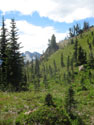
The Blackjack Ridge trail is fairly flat for about 1/4 mile then it gets down to work. The 3 miles up to the ridge top gains 3250'. The trailhead is at 2850' and the ridge top is at 6100'. The trail is steep but very smooth. There are few big steps, roots, or rocks. I had the lightest pack and lightest boots. With that advantage I was able to pull ahead for a change. The forest is dark and cool and we took no photos on this part of the trip.
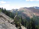
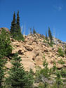
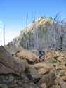
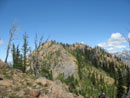
We made very good time. I stopped as we entered the burn after gaining 3000'. It took 1:45. There were only 4 or 5 logs down across the trail. One required crawling under and the rest we were able to get over. The walk through the burn was a nice contrast to the dark forest. There ware still a few flowers left though not many. We soon reached the ridge top. The real trail descends and we headed up the ridge to the right. The summit of Bootjack was now in sight.
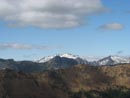
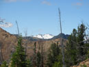
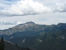
There is a reasonably good boot track up the ridge. Much easier to follow than on my first trip up. In short order we were on top of 6789' Bootjack. The last bit is an easy scramble. From the summit we had great views. Stuart, Cashmere, Ingalls, Harding, Daniel, and Highchair were easy to pick out. The mostly cloudy day was in fact almost cloud free. It was sunny but not blazing hot. We had lots of time to get over to Highchair so we spent nearly an hour on the summit.
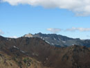
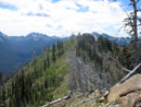
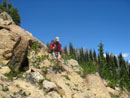
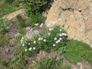
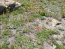
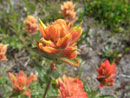
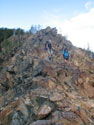
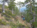
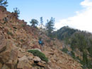
After Bootjack comes my favorite part of the trip. We dropped down from the summit and traversed towards the first bump. The route is around the left side then down and up to the second bump. This one we went nearly over the top. Flowers were still blooming around here, especially indian paintbrush. One more drop and the meadow, trees, and silver snags turn to rock. The ridge over to Highchair is narrow and all red rock. It is possible to traverse the very top of the ridge with only a few short drop downs. The alternative is to traverse below the top on the left side. This is not hard but requires a lot of side hilling.
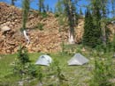
We chose a little of both. Great views from the ridge top. The distance from Bootjack to our campsite meadow is 1 1/2 miles. The sharp ridge portion is a little more than 1/2 mile. As I said earlier, the ridge top scramble is the highlight of the trip for me. Once across we dropped left off the ridge and quickly reached the meadow. My previous visits were earlier and the meadow was wet and filled with shooting stars. This time it was mostly dry. The shooting stars were done but there were some elephants head and some gentian. The tart was still 80% full.
The big question mark for this trip was whether or not we would find water this late. In June and early July I found numerous creeks flowing through the basin. The tart was filled with hundreds of polliwogs. They seemed to cover the bottom from end to end. Not very appetizing but it was clear water. We set up camp and took a rest. After 4100' of gain with overnight backpacks we were all beat. We still had 800' to scramble up to the summit of Highchair. Bob and Kolleen lightened their overnight packs and I took out my Golite Dawn I had stuffed in my backpack.
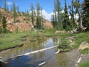
Even with less weight we were still lethargic. Most any way will get you to the top. We headed to the left in forest and soon found... a running creek. No tadpole water after all. There was still a pretty good flow. Higher up we angled to the right ridge and easily worked our way up. From the ridge top it was an easy scramble to the summit. The views are really outstanding from this vantage point. The Cradle is to the west across the valley. Cashmere, Stuart, Ingalls, and the long line of 6600 Ridge seemed close by.
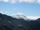
I could see Bill and Teanaway Peaks in the saddle between Stuart and Ingalls. Mt. Daniel now had clouds pushing around it from the west. They were slowly making headway though not getting far beyond the crest. It was warm but not hot and a gentle breeze kept the few bugs at bay. We had seen very few bugs until reaching our campsite. The tarn water was enough to keep a skeeter and non biting fly population going.
I could have stayed up there until near dark but Bob and Kolleen eventually felt the call of dinner. We did spend at least on hour on top. We took a steeper route down but it worked out just fine. Back at camp I took a stroll to fill my water bag and we were all set. A head net did come in handy to keep the bugs away. We lost the sun early since Highchair was directly west of us. As the sun disappeared it cooled very fast.
After dinner we managed to hang around until about 8:30 when we headed into our tents. By then it was already 43 degrees. Yikes! It cooled off real fast. There was also dew on the tents and it wasn't even dark yet. I closed my vestibule for warmth and by 11:00 pm I realized my mistake. I opened the vestibule but everything inside and outside of my tent was damp. The inside actually dried out by morning. My thermometer showed 38 degrees at 4:50 am inside my tent. It was the coldest night I have had since early spring. It was also the best I have slept in the backcountry since then.
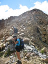
The flip side of losing the sun early was getting it back early. By 6:30 my tent was bathed in the glow of the morning sun. Although it was still only about 40 degrees it felt just fine in the sunshine. We got up earlier than we planned and by 8:15 we were packed and on our way. I was already sweating as we started back along the ridge. This time I suggested we stay on the very ridge crest as much as possible. It was fun as we did in fact manage to stay right on the crest almost the whole way.
Once across we had to climb back up to Bootjack. It was only 9:30 when we arrived. The west and north had been cloudy the day before but now the sky was almost entirely clear. We saw Daniel with no clouds and could also see Glacier Peak, Sloan Peak, the Monte Cristo group, and even Mt. Baker. Mt. Rainier was also in the clear. It was getting hot though it was still mid morning. I enjoyed our stay which lasted about 20 minutes. The day before we found a big bird feather laying on the summit. This day it was wedged vertically in some rocks. It seems someone did follow us up on Saturday. This was my third time up this trail and once again I did not see a single person.
The hike down was pretty fast. We took a very short break at the end of the burn and another at the only flat section about 1400' from the bottom. We dropped the 3925' from the summit of Bootjack to the car in just under 2 hours. Losing 2000' per hour is a lot of work. Thankfully the trail is soft and smooth making it much easier than on most trails. We were back at the car a little before 12:00 noon.
This was as much fun as an overnighter as it was as a day hike. It was nice to have more time on the summits and no pressure to hurry up. 5600' is a lot to gain and lose in a day but even with the heavier backpacks it was not too bad over two days. We had good weather, minimal bugs, great summit views, a really fun ridge ramble, good company, some flowers, and total solitude. Not bad for mid summer up Icicle Creek.
Click on thumbnails to get larger pictures.
Photo Page 2
Trips - 2007
Home
The Blackjack Ridge trail is fairly flat for about 1/4 mile then it gets down to work. The 3 miles up to the ridge top gains 3250'. The trailhead is at 2850' and the ridge top is at 6100'. The trail is steep but very smooth. There are few big steps, roots, or rocks. I had the lightest pack and lightest boots. With that advantage I was able to pull ahead for a change. The forest is dark and cool and we took no photos on this part of the trip.
We made very good time. I stopped as we entered the burn after gaining 3000'. It took 1:45. There were only 4 or 5 logs down across the trail. One required crawling under and the rest we were able to get over. The walk through the burn was a nice contrast to the dark forest. There ware still a few flowers left though not many. We soon reached the ridge top. The real trail descends and we headed up the ridge to the right. The summit of Bootjack was now in sight.
There is a reasonably good boot track up the ridge. Much easier to follow than on my first trip up. In short order we were on top of 6789' Bootjack. The last bit is an easy scramble. From the summit we had great views. Stuart, Cashmere, Ingalls, Harding, Daniel, and Highchair were easy to pick out. The mostly cloudy day was in fact almost cloud free. It was sunny but not blazing hot. We had lots of time to get over to Highchair so we spent nearly an hour on the summit.
After Bootjack comes my favorite part of the trip. We dropped down from the summit and traversed towards the first bump. The route is around the left side then down and up to the second bump. This one we went nearly over the top. Flowers were still blooming around here, especially indian paintbrush. One more drop and the meadow, trees, and silver snags turn to rock. The ridge over to Highchair is narrow and all red rock. It is possible to traverse the very top of the ridge with only a few short drop downs. The alternative is to traverse below the top on the left side. This is not hard but requires a lot of side hilling.
We chose a little of both. Great views from the ridge top. The distance from Bootjack to our campsite meadow is 1 1/2 miles. The sharp ridge portion is a little more than 1/2 mile. As I said earlier, the ridge top scramble is the highlight of the trip for me. Once across we dropped left off the ridge and quickly reached the meadow. My previous visits were earlier and the meadow was wet and filled with shooting stars. This time it was mostly dry. The shooting stars were done but there were some elephants head and some gentian. The tart was still 80% full.
The big question mark for this trip was whether or not we would find water this late. In June and early July I found numerous creeks flowing through the basin. The tart was filled with hundreds of polliwogs. They seemed to cover the bottom from end to end. Not very appetizing but it was clear water. We set up camp and took a rest. After 4100' of gain with overnight backpacks we were all beat. We still had 800' to scramble up to the summit of Highchair. Bob and Kolleen lightened their overnight packs and I took out my Golite Dawn I had stuffed in my backpack.
Even with less weight we were still lethargic. Most any way will get you to the top. We headed to the left in forest and soon found... a running creek. No tadpole water after all. There was still a pretty good flow. Higher up we angled to the right ridge and easily worked our way up. From the ridge top it was an easy scramble to the summit. The views are really outstanding from this vantage point. The Cradle is to the west across the valley. Cashmere, Stuart, Ingalls, and the long line of 6600 Ridge seemed close by.
I could see Bill and Teanaway Peaks in the saddle between Stuart and Ingalls. Mt. Daniel now had clouds pushing around it from the west. They were slowly making headway though not getting far beyond the crest. It was warm but not hot and a gentle breeze kept the few bugs at bay. We had seen very few bugs until reaching our campsite. The tarn water was enough to keep a skeeter and non biting fly population going.
I could have stayed up there until near dark but Bob and Kolleen eventually felt the call of dinner. We did spend at least on hour on top. We took a steeper route down but it worked out just fine. Back at camp I took a stroll to fill my water bag and we were all set. A head net did come in handy to keep the bugs away. We lost the sun early since Highchair was directly west of us. As the sun disappeared it cooled very fast.
After dinner we managed to hang around until about 8:30 when we headed into our tents. By then it was already 43 degrees. Yikes! It cooled off real fast. There was also dew on the tents and it wasn't even dark yet. I closed my vestibule for warmth and by 11:00 pm I realized my mistake. I opened the vestibule but everything inside and outside of my tent was damp. The inside actually dried out by morning. My thermometer showed 38 degrees at 4:50 am inside my tent. It was the coldest night I have had since early spring. It was also the best I have slept in the backcountry since then.
The flip side of losing the sun early was getting it back early. By 6:30 my tent was bathed in the glow of the morning sun. Although it was still only about 40 degrees it felt just fine in the sunshine. We got up earlier than we planned and by 8:15 we were packed and on our way. I was already sweating as we started back along the ridge. This time I suggested we stay on the very ridge crest as much as possible. It was fun as we did in fact manage to stay right on the crest almost the whole way.
Once across we had to climb back up to Bootjack. It was only 9:30 when we arrived. The west and north had been cloudy the day before but now the sky was almost entirely clear. We saw Daniel with no clouds and could also see Glacier Peak, Sloan Peak, the Monte Cristo group, and even Mt. Baker. Mt. Rainier was also in the clear. It was getting hot though it was still mid morning. I enjoyed our stay which lasted about 20 minutes. The day before we found a big bird feather laying on the summit. This day it was wedged vertically in some rocks. It seems someone did follow us up on Saturday. This was my third time up this trail and once again I did not see a single person.
The hike down was pretty fast. We took a very short break at the end of the burn and another at the only flat section about 1400' from the bottom. We dropped the 3925' from the summit of Bootjack to the car in just under 2 hours. Losing 2000' per hour is a lot of work. Thankfully the trail is soft and smooth making it much easier than on most trails. We were back at the car a little before 12:00 noon.
This was as much fun as an overnighter as it was as a day hike. It was nice to have more time on the summits and no pressure to hurry up. 5600' is a lot to gain and lose in a day but even with the heavier backpacks it was not too bad over two days. We had good weather, minimal bugs, great summit views, a really fun ridge ramble, good company, some flowers, and total solitude. Not bad for mid summer up Icicle Creek.
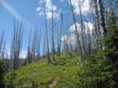
Silvered Burn |
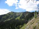
Bootjack Mountain |
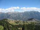
Blackjack Ridge |
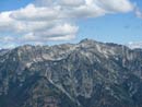
Grindstone Mountain |
Mt. Daniel |
The Cradle |
Interesting Rock |
Off Summit |
Traversing |
Second Bump |
Bob |
Kolleen |
Looking Back |
Daisies |
Paintbrush |
 Close Up
 |
Mt. Daniel Again |
On The Ridge |
Trees On Ridge |
Leaving Ridge |
Cashmere Mountain |
Campsite |
Tarn |
Near Summit |
Clouds Coming In |
Photo Page 2
Trips - 2007
Home