8/31-9/3/07
Kim brought up the idea for this trip a month ago.
A week earlier we biked up the White Chuck Road to the seven mile marker
on a scouting mission. The road is washed out at 1.7 miles and there
are 4 more washouts to the point where we turned around. It was a real
pain getting the bikes around the washouts so we decided to do the whole
loop on foot. This route would be a loop with only 3.8 miles repeated
coming out. It would include two lakes, at least one peak, a glorious
meadow ridge walk, and a brand new trail that is virtually unknown. We
could hardly wait to get started.
Day 1
Kim picked my up at 6:20 am and we headed north. Traffic was fairly light for a Friday morning and we went through Everett with no slow downs. We dropped off some salmon with Gary and Dawn on the way to Darrington. They graciously provided us with a lot of recent information on conditions along our route and promised a dinner upon our return. From there it was on to the White Chuck Road and the washout at the 1.7 mile mark. As expected there were no cars there. We began at an elevation of about 1150'.
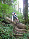
The previous week we had hauled bikes over the washouts and now even though we had backpacks with four days worth of gear it was much easier without the bikes. We did some sawing the previous week which also helped. Not very long after the first washout a flagged road goes off uphill to the left. We followed it as it climbed above the second washout. More flagging shows the point in which to exit the road. The trail down is steep but perfectly fine. The last 20 feet is the steepest. Hauling bikes up and down this 110' was a real chore. Without them we scampered right on down.
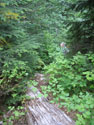
Farther along we came to washout #3. It is the shortest and has the least elevation gain. It is also the one with the most logs to climb over. We had cut out a few small logs here too so it was not as bad as the previous week. Just a few minutes later we reached another small washout. The old wooden culvert/bridge was standing but the road before it is gone. The creek now falls off in a waterfall. A short trail goes right of the road to cross the creek hopping rocks.
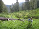
The White Chuck River Road has only been closed for less than four years but it is converting to trail in many places. A brown track runs down the middle with green grass and low plants everywhere else across the road. With those four washouts behind us we had smooth sailing up to the bridge over the White Chuck. The middle of the bridge gives a great viewpoint to see how wide the river ran for such a short time back in November 2003. Trees are everywhere in the river bed and the current river takes up only a fraction of the whole bed.
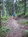
The fairly new but now not accessible White Chuck Bench Trail trailhead is at the far end of the bridge. The sign and outhouse are standing though the parking lot is reverting to nature rapidly. A little uphill walking and we were soon at the 5.5 mile point where the road to Rat Trap Pass goes off uphill left. This is 3.8 miles from our start. This road is still in pretty good shape. A few rocks have fallen onto the road. Some small trees have fallen though they have all been cut out. Depending on which books or maps you believe it is 2.3 to 2.5 miles to the old Meadow Mountain Road turnoff.
After the Meadow Mountain Road was closed this became the pre 2003 washout trailhead for both Meadow Mountain and Crystal Lake. There are no signs at all. The road has a small berm with a trail over it and there is a short trail around the berm on the right side. It is not far after a left turning switchback and before the road begins to climb. We stopped here for lunch. The road is easy to follow. In places it is getting overgrown but not too badly so far. It climbs up then drops down towards Crystal Creek. As it gets down towards the creek the brush gets thicker.
We came upon the sign for Meadow Mountain and Crystal Lake. We took the left "road" continuing up the valley of Crystal Creek. In places the route is great. In places it is very overgrown. While brush is up to 10 feet tall in some sections the tread remains bare. You should have no trouble staying on it. Higher up there are small creeks to cross and the tread gets a bit boggy. These are all short. The end of the road is full of five foot tall brush. The only way you know you are there is that the trail turns left and begins to ascend steeply.
The trail to the lake is steep but short. As elevation is gained the brush lessens then goes away. Finally we entered forest. The day began with some sun but had been clouding up. As we neared the lake we were near the base of the clouds. The route finally relented and entered a meadow. We easily crossed the outlet and followed the meadows to the 4485' lake. The right side of the lake is almost all meadow. It's very pretty. The meadow is full of ripe huckleberries and blueberries. Ripe berries were all along our route for the next two days as well.
Just as we began to set up camp the rain began. It rained for about 15 minutes then stopped. Not too bad so far. We went searching for the brand new trail to Circle Peak. It was just finished the same week. Circle Peak was accessed via the Boundary Bridge over the Suiattle River. The bridge is still there but the far shore is gone. The trail had been inaccessible since the 2003 flood. We knew that the new trail went over to Circle Peak. We did not know the route. Crossing the outlet near the lake immediately put us on the new trail. A very nice trail it is. More on that later.
We had dinner then walked to the far end of the lake looking for the way trail over the ridge to Meadow Lake. That would be our next objective after Circle Peak. Clouds were hanging just above the lake giving it a surreal feel. At the far end Kim spotted a path leading uphill. I followed it a short way to verify this was the trail we sought and it was. We headed back to camp and were soon in bed. After 11 miles and 3600' of gain crossing washouts and fighting brush we were beat. Soon after I turned in it began to rain and continued for several hours. That proved to be the last rain of the trip.
Day 2
Saturday morning dawned with some blue sky. I recorded 38 degrees for the low temperature overnight but the sun rapidly warmed us up. We stayed in our bags until 7:30 and it was 9:00 am when we finally were packed for the day. My guess was that the new trail would switchback up 700' to a pass then drop about 300' to meet the Circle Peak Trail in a meadow. In fact it began a long traverse to the northwest. The trail is well built and mostly level. There are some ups and downs but none are steep or long. The traverse continues until the ridge is crossed at an elevation near to that of Crystal Lake. We began to switchback down and wondered why we were not heading towards Circle Peak. The reason quickly became apparent.
We could now see the Circle Creek Road right below us. About 100' above the road the grade turned up the valley and leveled off. A minute later we found a boot path up from near the end of the road. Trail work continued as we were now on the old Circle Peak Trail. Just beyond the parking lot a well hidden old path meets the route. This must have been the old lookout trail. The Circle Peak trail gains 200' in two miles but is never steep. The grade is consistent. We went through dark forest and into the big meadow over the ridge from Crystal Lake.
Several old puncheon bridges have been replaced and some decrepit ones soon will be. We soon broke out of the trees and entered a lush hillside meadow that went all the way up the mountain. This meadow theme was now firmly established and would continue until Fire Mountain. The sweetest blueberries were in the lower meadow but they continued most of the way up. We were surprised to not see any bears with all those berries. The tread is good but a lack of boots is allowing the brush to crowd the trail. It was wet from the previous days rain and my boots were soon soaked. I should have brought gaiters.
At the ridge top the route crossed to the other side and traversed below the summit. A few switchbacks and we were on top. There is a nice open area then a few rocky points. The real lookout is beyond those. That requires a scramble down to a saddle then a climb up. The elevation difference between the first and actual summit is minimal. We chose not to look for a reasonable route and enjoyed the view from the first summit. And what a view!
Glacier Peak is very close. So is White Chuck, and Pugh, and Sloan, and Black, and Green, and Red, and Buckindy, and Dome. Three Fingers and Whitehorse one way and Baker and Shuksan another. This is one of the best summit viewpoints I have been to and it's only 5983' high. We sat and marveled at the view. When the Boundary Bridge is restored it will only be 2 miles and 2000' to get up here. Probably the best short hike I could recommend.
We had planned a quick jaunt over to Circle Peak then back then on to Meadow Lake and well along the Meadow Mountain trail this day. It was not to be. The trail from Crystal Lake to Circle Peak and back ended up being 8 miles with about 2700' of gain. We had to adjust our plans. The hike back to camp was easy and after a break we began to pack up. It was now about 4:30. We hiked down to the end of lake and started up the route to Meadow Lake.
The route begins fine. Soon there are some trees down. Then there are some bigger trees down. Many of these look to be recent. While the route finding proved to be a pain we did stay on route. It was steep but never exposed and dangerous. One tree was long and at least 8 feet in diameter. They grow them big up there. I had to get down and crawl under it. 630 vertical feet later we were at the saddle. There is a trail down the other side but it could use some maintenance. We dropped quickly to a meadow then found the trail on the other side.
More switchbacks dropped us down to a larger meadow. At first we thought the long narrow lake was all that was left of 4763' Meadow Lake. It didn't take long to realize that this was the outlet. It is a meandering creek that goes from one side of the meadow to the other. A couple minutes later we reached Meadow Lake. The lake looks like it was pretty trashed at one time. Chucks of trees were hacked out for no reason. The lake is surrounded by berry bushes with very ripe berries. I followed signs to the outhouse only to find it is in awfully sad shape.
It took us over an hour to cross the ridge and we now decided that Meadow Lake would do for this night. We set up camp and I looked for a rock to use to throw the food line over a branch. I looked all over the site and found no rocks. Hmm... what to do? There was a light frying pan laying there. I tied the line to the hole in the handle and gave it a heave. Mission accomplished. High clouds drifted in and it was much warming that evening. The lowest temperature I noticed was 48 degrees. We knew day three would now have to be a long one so we were early to bed and early to rise.
Day 3
We were packed up and on the trail by 8:00 am. The trail up to the Meadow Mountain Trail is only .70 miles gaining 240' to the 5000' intersection. Now the hard work really began to pay off. The route goes from forest to meadows and back again. There are many ups and downs. Never are they steep. The tread is in fine shape most of the way. This is a well constructed trail. It has seen little use since the Meadow Mountain Road closure added 5 miles to the trip and I bet almost none since the 2003 flood. It was never hard to follow. It was not muddy. Even where brush has encroached it is low. It was just beautiful.
We climbed up to 5600' and the views began. Pugh then White Chuck. Lost Creek Ridge to the south. Then an in your face look at Glacier Peak. The day was mostly sunny but we saw two big lenticular clouds over Glacier Peak. The forecast when we left was for rainy weather to come in Sunday evening. That was another reason to push ourselves this day. The lenticular seemed to confirm our good weather window was near to slamming shut. Farther along the ridge the forest became less and the meadows bigger. Big, really big, and just plain huge.
One open meadow gave us a look down to much of the White Chuck River valley. A wide mass of brown mud surrounding a forest of dead trees was pretty obviously the remains of the Kennedy Hot Springs area. There are several huge washouts along the south side of the valley opposite the White Chuck River Trail. Most flowers are finished in the meadows but we saw lots of western anemone and fireweed plus a number of others. There were more shades of green than you could imagine.
After a couple miles we dropped down into a grassy basin with a creek running. Talus slopes lined one side of the basin. This would be a good spot to camp. The next potable water we found was all the way at the other end of the ridge below Fire Mountain. We climbed then switchbacked down into forest. Another climb brought us into the biggest meadows of the day. We switchbacked up the open slopes to the high point of our trip. The trail touches the ridge at 6000'.
What views. The Monte Cristo peaks now showed over Lost Creek Ridge. To all those southern peaks we now added Baker (in clouds), Buckindy, Green, Snowking, Dome. and many more I could not identify. Right across the valley was Lime Ridge. That looked even more meadowed than Meadow Ridge if that's possible. Circle Peak appeared as a small bump over the ridge. What a place! Just below us on the north side was a rock and heather basin. There is a way trail across it. A small bit of snow is still there.
We thought this way trail led to Diamond Lake but a check of the map showed we had passed the lake turnoff some time ago. The way trail shows on one of my maps but we saw no trace of another trail. This high point was a great place for lunch. The going now was mostly downhill but still with ups and downs. We traversed through a number of basins, crossing low ridges in between. At long last Fire Mountain came into view. We passed several dry creeks and then found one with a good flow.
We filled our water bottles and had a last break before beginning the descent. A few minutes later we passed the obvious remains of a very old shelter. At about 5400' our descent began. The parking lot at the old White Chuck Trail trailhead was 3000' below us. We immediately entered forest and said good-bye to an amazing two days of meadows. The trail down is in pretty good shape. It too is well graded with no especially steep sections.
We knew that there were some 32 trees down across the trail in our 3 1/2 mile descent but there were few up high. This must be the longest 3 1/2 miles I have ever hiked. It just went on and on. Lower down we started to come upon the downed trees but most were no problem to get over, under, or around. At one point the trail ahead was completely washed out with trees strewn all over the slope. While I looked ahead Kim noticed the trail used to switchback here. We dropped down and avoided the whole mess.
A loud rushing noise alerted us to our approaching Fire Creek. At the creek there is no bridge but there are several logs all the way across. The largest one had crosshatching cuts for traction at one time. Now it has more moss than traction. We slowly worked our way across. On the other side things changed immediately. The amount of moss is incredible. There are puncheon bridges that still have shape but will crumble with a strong breeze. Now we really found the downed logs. Still, we had only minor difficulties getting by. Frogs and huge mushrooms were two themes of this trip. We saw dozens of both. This section of trail was rife with each.
At about 3200' we reached a broad flat area and a sharp switchback to the right. There is a stake with a blue flag signifying the start of the old trail newly flagged to replace the White Chuck River trail. Planned that is until the 2006 floods further destroyed the road approach. This route would definitely be better than the dozen or so washouts along the trail to the Kennedy Hot Springs site. Speaking of washouts...
At long last we reached the intersection with the White Chuck River Trail. Kim had used her contacts to learn valuable information about our intended route. The new trail, the recent trail conditions, downed trees, and the washouts. She had mentioned to me early on that there is a washout along the last mile of the White Chuck Trail before the old trailhead. What she didn't mention until now is that the ranger who had recently crossed it took an hour. Huh? an hour? How bad was it? We would soon find out.
The next problem was the crossing of Fire Creek again. We were very happy to find that the bridge had survived the floods with no damage. Now on to the washout. There were quite a few trees down on this trail but none caused big problems. Oh yeah, that washout.
We reached the obvious problem spot and saw flagging heading up the slope. Ahead were downed trees and a lot of missing slope going a good 100' up. It was now near 6:40. We had well over an hour of daylight left. Up we went. I expected the tape to go up to the top of the washout then right down the other side. Well, not exactly. We went up and up and still more tape above us. When we began to traverse there were long and very wide logs to get around. The slope is very steep. I thought I saw a light path down near the top of the washout.
Going down that far is a little dangerous as the washout is far from stable. I managed to get my pack wedged between two trees at one point. Kim did great on this more and more exposed scramble. At times the only option was to jump from one tree to another. The ground was mostly softer duff that allowed at least a little purchase. Our progress was painstakingly slow. When I thought we were near the end of the washout we spotted more tape going higher still. Down was impossibly steep so up we went.
By now it was nearing 7:30 and getting dark in the forest. I had visions of trying to scramble this crap with headlamps. Finally we were able to spot a flag down lower and we scampered in that direction. It took quite a while to descend as the slope was steeper still. Finally I spotted the trail below and we left the flags and worked our way down to the trail. It was 7:40. It took us an hour to make it across. The same amount of time it took the ranger. I was very happy to be back on flat trail. We cruised on out over and under a number of other downed trees. Kim even found the big tree she had helped to blow up on a trail maintenance trip.
We reached the trail register and each took a photo of the names signed in this year. Lots of failed scouting trips and one person who came out after starting the Crest Trail at Stevens Pass. That would be an interesting trip report. We reached the trailhead just as darkness set in. We found one of the old campsites and set up our tents. We could hear Owl Creek but found mostly a sea of devils club in our way. As tired as we were we improvised for dinner and did not cook. We used what water that was left to drink. It was a long day from 8:00 am to 8:15 pm. We traveled only 13 miles with 2600' gained and close to 5,000' lost.
Day 4
We were glad to be beyond all the hazards as Monday was supposed to be a mostly rainy day. When I woke up I saw some high clouds but no signs of rain. The evening was the warmest yet. I slept little and the lowest temperature I saw was 56 degrees. In daylight it was no problem getting water for breakfast and refilling our water bottles. The old trailhead is amazing in a sad way. The new double bathroom was put in in about 2001 or 2002. It now has skinny trees around it that reach the peak of the roof. It's beginning to look like an ancient Mayan ruin. Someone will fight through brush and rediscover it in 10 years. The parking lot is all green grass and a few trees. This was an immaculately kept place just 4 years ago.
It was also a busy place. On a Labor Day weekend the lot would certainly be full. This day we were the only people within miles of it. Kim has done a lot of work on the White Chuck Trail and I know she feels a real sense of loss. After a tear or two were shed we packed up for the last 8.3 miles of road walking. The road is still in reasonable shape most of the way. There is one small washout a few miles down that took off the edge of the road. Soon we were back at milepost 7 where we had biked to a week earlier. The rest of the way was on familiar territory.
At a slow hikers pace we saw things that we had missed at higher speed in a car. There is a beautiful waterfall along the road. Why did a number of huge trees survive the logging? Trees right along the edge of the road. One looked to ge at least eight feet in diameter. At the Owl Creek bridge we noticed bent guard rails. The creek appears to have risen enough to wash over the bridge. Amazing. At the half way point we closed the loop at the turnoff to Rat Trap Pass. We crossed the White Chuck and prepared for the final washouts. After the White Chuck Trail washout those proved to be as easy as flat trail.
By 1:30 we came out of the last washout and reached Kim's truck. We were both beat. This was a phenomenal trip. As expected we saw nobody else along the route. We saw dozens of frogs, a few marmots, huge mushrooms, and no large animals. With the lack of people up there and the wealth of ripe berries we really expected to see more animals. The new trail to Circle Peak is a winner. The lakes were nice. The road bushwhacking was a bit of a struggle but not all that difficult. The meadows were sublime. The views were among the best I have had the pleasure of seeing. And of course the company was terrific. Thanks Kim.
For the four days we hiked about 41 miles. Hard to be exact as one trail is too new for maps and the trail between the lakes is not official. Elevation gain was right about at 10,000'. It was a lot of work but it was worth every scar we earned. On the way home we dropped in on Gary and Dawn to relay the story of our trip and feast on a great salmon dinner. A fine ending to a very nice trip.
Click on thumbnails to get larger pictures.
Photo Page 2
Trips - 2007
Home
Day 1
Kim picked my up at 6:20 am and we headed north. Traffic was fairly light for a Friday morning and we went through Everett with no slow downs. We dropped off some salmon with Gary and Dawn on the way to Darrington. They graciously provided us with a lot of recent information on conditions along our route and promised a dinner upon our return. From there it was on to the White Chuck Road and the washout at the 1.7 mile mark. As expected there were no cars there. We began at an elevation of about 1150'.
The previous week we had hauled bikes over the washouts and now even though we had backpacks with four days worth of gear it was much easier without the bikes. We did some sawing the previous week which also helped. Not very long after the first washout a flagged road goes off uphill to the left. We followed it as it climbed above the second washout. More flagging shows the point in which to exit the road. The trail down is steep but perfectly fine. The last 20 feet is the steepest. Hauling bikes up and down this 110' was a real chore. Without them we scampered right on down.
Farther along we came to washout #3. It is the shortest and has the least elevation gain. It is also the one with the most logs to climb over. We had cut out a few small logs here too so it was not as bad as the previous week. Just a few minutes later we reached another small washout. The old wooden culvert/bridge was standing but the road before it is gone. The creek now falls off in a waterfall. A short trail goes right of the road to cross the creek hopping rocks.
The White Chuck River Road has only been closed for less than four years but it is converting to trail in many places. A brown track runs down the middle with green grass and low plants everywhere else across the road. With those four washouts behind us we had smooth sailing up to the bridge over the White Chuck. The middle of the bridge gives a great viewpoint to see how wide the river ran for such a short time back in November 2003. Trees are everywhere in the river bed and the current river takes up only a fraction of the whole bed.
The fairly new but now not accessible White Chuck Bench Trail trailhead is at the far end of the bridge. The sign and outhouse are standing though the parking lot is reverting to nature rapidly. A little uphill walking and we were soon at the 5.5 mile point where the road to Rat Trap Pass goes off uphill left. This is 3.8 miles from our start. This road is still in pretty good shape. A few rocks have fallen onto the road. Some small trees have fallen though they have all been cut out. Depending on which books or maps you believe it is 2.3 to 2.5 miles to the old Meadow Mountain Road turnoff.
After the Meadow Mountain Road was closed this became the pre 2003 washout trailhead for both Meadow Mountain and Crystal Lake. There are no signs at all. The road has a small berm with a trail over it and there is a short trail around the berm on the right side. It is not far after a left turning switchback and before the road begins to climb. We stopped here for lunch. The road is easy to follow. In places it is getting overgrown but not too badly so far. It climbs up then drops down towards Crystal Creek. As it gets down towards the creek the brush gets thicker.
We came upon the sign for Meadow Mountain and Crystal Lake. We took the left "road" continuing up the valley of Crystal Creek. In places the route is great. In places it is very overgrown. While brush is up to 10 feet tall in some sections the tread remains bare. You should have no trouble staying on it. Higher up there are small creeks to cross and the tread gets a bit boggy. These are all short. The end of the road is full of five foot tall brush. The only way you know you are there is that the trail turns left and begins to ascend steeply.
The trail to the lake is steep but short. As elevation is gained the brush lessens then goes away. Finally we entered forest. The day began with some sun but had been clouding up. As we neared the lake we were near the base of the clouds. The route finally relented and entered a meadow. We easily crossed the outlet and followed the meadows to the 4485' lake. The right side of the lake is almost all meadow. It's very pretty. The meadow is full of ripe huckleberries and blueberries. Ripe berries were all along our route for the next two days as well.
Just as we began to set up camp the rain began. It rained for about 15 minutes then stopped. Not too bad so far. We went searching for the brand new trail to Circle Peak. It was just finished the same week. Circle Peak was accessed via the Boundary Bridge over the Suiattle River. The bridge is still there but the far shore is gone. The trail had been inaccessible since the 2003 flood. We knew that the new trail went over to Circle Peak. We did not know the route. Crossing the outlet near the lake immediately put us on the new trail. A very nice trail it is. More on that later.
We had dinner then walked to the far end of the lake looking for the way trail over the ridge to Meadow Lake. That would be our next objective after Circle Peak. Clouds were hanging just above the lake giving it a surreal feel. At the far end Kim spotted a path leading uphill. I followed it a short way to verify this was the trail we sought and it was. We headed back to camp and were soon in bed. After 11 miles and 3600' of gain crossing washouts and fighting brush we were beat. Soon after I turned in it began to rain and continued for several hours. That proved to be the last rain of the trip.
Day 2
Saturday morning dawned with some blue sky. I recorded 38 degrees for the low temperature overnight but the sun rapidly warmed us up. We stayed in our bags until 7:30 and it was 9:00 am when we finally were packed for the day. My guess was that the new trail would switchback up 700' to a pass then drop about 300' to meet the Circle Peak Trail in a meadow. In fact it began a long traverse to the northwest. The trail is well built and mostly level. There are some ups and downs but none are steep or long. The traverse continues until the ridge is crossed at an elevation near to that of Crystal Lake. We began to switchback down and wondered why we were not heading towards Circle Peak. The reason quickly became apparent.
We could now see the Circle Creek Road right below us. About 100' above the road the grade turned up the valley and leveled off. A minute later we found a boot path up from near the end of the road. Trail work continued as we were now on the old Circle Peak Trail. Just beyond the parking lot a well hidden old path meets the route. This must have been the old lookout trail. The Circle Peak trail gains 200' in two miles but is never steep. The grade is consistent. We went through dark forest and into the big meadow over the ridge from Crystal Lake.
Several old puncheon bridges have been replaced and some decrepit ones soon will be. We soon broke out of the trees and entered a lush hillside meadow that went all the way up the mountain. This meadow theme was now firmly established and would continue until Fire Mountain. The sweetest blueberries were in the lower meadow but they continued most of the way up. We were surprised to not see any bears with all those berries. The tread is good but a lack of boots is allowing the brush to crowd the trail. It was wet from the previous days rain and my boots were soon soaked. I should have brought gaiters.
At the ridge top the route crossed to the other side and traversed below the summit. A few switchbacks and we were on top. There is a nice open area then a few rocky points. The real lookout is beyond those. That requires a scramble down to a saddle then a climb up. The elevation difference between the first and actual summit is minimal. We chose not to look for a reasonable route and enjoyed the view from the first summit. And what a view!
Glacier Peak is very close. So is White Chuck, and Pugh, and Sloan, and Black, and Green, and Red, and Buckindy, and Dome. Three Fingers and Whitehorse one way and Baker and Shuksan another. This is one of the best summit viewpoints I have been to and it's only 5983' high. We sat and marveled at the view. When the Boundary Bridge is restored it will only be 2 miles and 2000' to get up here. Probably the best short hike I could recommend.
We had planned a quick jaunt over to Circle Peak then back then on to Meadow Lake and well along the Meadow Mountain trail this day. It was not to be. The trail from Crystal Lake to Circle Peak and back ended up being 8 miles with about 2700' of gain. We had to adjust our plans. The hike back to camp was easy and after a break we began to pack up. It was now about 4:30. We hiked down to the end of lake and started up the route to Meadow Lake.
The route begins fine. Soon there are some trees down. Then there are some bigger trees down. Many of these look to be recent. While the route finding proved to be a pain we did stay on route. It was steep but never exposed and dangerous. One tree was long and at least 8 feet in diameter. They grow them big up there. I had to get down and crawl under it. 630 vertical feet later we were at the saddle. There is a trail down the other side but it could use some maintenance. We dropped quickly to a meadow then found the trail on the other side.
More switchbacks dropped us down to a larger meadow. At first we thought the long narrow lake was all that was left of 4763' Meadow Lake. It didn't take long to realize that this was the outlet. It is a meandering creek that goes from one side of the meadow to the other. A couple minutes later we reached Meadow Lake. The lake looks like it was pretty trashed at one time. Chucks of trees were hacked out for no reason. The lake is surrounded by berry bushes with very ripe berries. I followed signs to the outhouse only to find it is in awfully sad shape.
It took us over an hour to cross the ridge and we now decided that Meadow Lake would do for this night. We set up camp and I looked for a rock to use to throw the food line over a branch. I looked all over the site and found no rocks. Hmm... what to do? There was a light frying pan laying there. I tied the line to the hole in the handle and gave it a heave. Mission accomplished. High clouds drifted in and it was much warming that evening. The lowest temperature I noticed was 48 degrees. We knew day three would now have to be a long one so we were early to bed and early to rise.
Day 3
We were packed up and on the trail by 8:00 am. The trail up to the Meadow Mountain Trail is only .70 miles gaining 240' to the 5000' intersection. Now the hard work really began to pay off. The route goes from forest to meadows and back again. There are many ups and downs. Never are they steep. The tread is in fine shape most of the way. This is a well constructed trail. It has seen little use since the Meadow Mountain Road closure added 5 miles to the trip and I bet almost none since the 2003 flood. It was never hard to follow. It was not muddy. Even where brush has encroached it is low. It was just beautiful.
We climbed up to 5600' and the views began. Pugh then White Chuck. Lost Creek Ridge to the south. Then an in your face look at Glacier Peak. The day was mostly sunny but we saw two big lenticular clouds over Glacier Peak. The forecast when we left was for rainy weather to come in Sunday evening. That was another reason to push ourselves this day. The lenticular seemed to confirm our good weather window was near to slamming shut. Farther along the ridge the forest became less and the meadows bigger. Big, really big, and just plain huge.
One open meadow gave us a look down to much of the White Chuck River valley. A wide mass of brown mud surrounding a forest of dead trees was pretty obviously the remains of the Kennedy Hot Springs area. There are several huge washouts along the south side of the valley opposite the White Chuck River Trail. Most flowers are finished in the meadows but we saw lots of western anemone and fireweed plus a number of others. There were more shades of green than you could imagine.
After a couple miles we dropped down into a grassy basin with a creek running. Talus slopes lined one side of the basin. This would be a good spot to camp. The next potable water we found was all the way at the other end of the ridge below Fire Mountain. We climbed then switchbacked down into forest. Another climb brought us into the biggest meadows of the day. We switchbacked up the open slopes to the high point of our trip. The trail touches the ridge at 6000'.
What views. The Monte Cristo peaks now showed over Lost Creek Ridge. To all those southern peaks we now added Baker (in clouds), Buckindy, Green, Snowking, Dome. and many more I could not identify. Right across the valley was Lime Ridge. That looked even more meadowed than Meadow Ridge if that's possible. Circle Peak appeared as a small bump over the ridge. What a place! Just below us on the north side was a rock and heather basin. There is a way trail across it. A small bit of snow is still there.
We thought this way trail led to Diamond Lake but a check of the map showed we had passed the lake turnoff some time ago. The way trail shows on one of my maps but we saw no trace of another trail. This high point was a great place for lunch. The going now was mostly downhill but still with ups and downs. We traversed through a number of basins, crossing low ridges in between. At long last Fire Mountain came into view. We passed several dry creeks and then found one with a good flow.
We filled our water bottles and had a last break before beginning the descent. A few minutes later we passed the obvious remains of a very old shelter. At about 5400' our descent began. The parking lot at the old White Chuck Trail trailhead was 3000' below us. We immediately entered forest and said good-bye to an amazing two days of meadows. The trail down is in pretty good shape. It too is well graded with no especially steep sections.
We knew that there were some 32 trees down across the trail in our 3 1/2 mile descent but there were few up high. This must be the longest 3 1/2 miles I have ever hiked. It just went on and on. Lower down we started to come upon the downed trees but most were no problem to get over, under, or around. At one point the trail ahead was completely washed out with trees strewn all over the slope. While I looked ahead Kim noticed the trail used to switchback here. We dropped down and avoided the whole mess.
A loud rushing noise alerted us to our approaching Fire Creek. At the creek there is no bridge but there are several logs all the way across. The largest one had crosshatching cuts for traction at one time. Now it has more moss than traction. We slowly worked our way across. On the other side things changed immediately. The amount of moss is incredible. There are puncheon bridges that still have shape but will crumble with a strong breeze. Now we really found the downed logs. Still, we had only minor difficulties getting by. Frogs and huge mushrooms were two themes of this trip. We saw dozens of both. This section of trail was rife with each.
At about 3200' we reached a broad flat area and a sharp switchback to the right. There is a stake with a blue flag signifying the start of the old trail newly flagged to replace the White Chuck River trail. Planned that is until the 2006 floods further destroyed the road approach. This route would definitely be better than the dozen or so washouts along the trail to the Kennedy Hot Springs site. Speaking of washouts...
At long last we reached the intersection with the White Chuck River Trail. Kim had used her contacts to learn valuable information about our intended route. The new trail, the recent trail conditions, downed trees, and the washouts. She had mentioned to me early on that there is a washout along the last mile of the White Chuck Trail before the old trailhead. What she didn't mention until now is that the ranger who had recently crossed it took an hour. Huh? an hour? How bad was it? We would soon find out.
The next problem was the crossing of Fire Creek again. We were very happy to find that the bridge had survived the floods with no damage. Now on to the washout. There were quite a few trees down on this trail but none caused big problems. Oh yeah, that washout.
We reached the obvious problem spot and saw flagging heading up the slope. Ahead were downed trees and a lot of missing slope going a good 100' up. It was now near 6:40. We had well over an hour of daylight left. Up we went. I expected the tape to go up to the top of the washout then right down the other side. Well, not exactly. We went up and up and still more tape above us. When we began to traverse there were long and very wide logs to get around. The slope is very steep. I thought I saw a light path down near the top of the washout.
Going down that far is a little dangerous as the washout is far from stable. I managed to get my pack wedged between two trees at one point. Kim did great on this more and more exposed scramble. At times the only option was to jump from one tree to another. The ground was mostly softer duff that allowed at least a little purchase. Our progress was painstakingly slow. When I thought we were near the end of the washout we spotted more tape going higher still. Down was impossibly steep so up we went.
By now it was nearing 7:30 and getting dark in the forest. I had visions of trying to scramble this crap with headlamps. Finally we were able to spot a flag down lower and we scampered in that direction. It took quite a while to descend as the slope was steeper still. Finally I spotted the trail below and we left the flags and worked our way down to the trail. It was 7:40. It took us an hour to make it across. The same amount of time it took the ranger. I was very happy to be back on flat trail. We cruised on out over and under a number of other downed trees. Kim even found the big tree she had helped to blow up on a trail maintenance trip.
We reached the trail register and each took a photo of the names signed in this year. Lots of failed scouting trips and one person who came out after starting the Crest Trail at Stevens Pass. That would be an interesting trip report. We reached the trailhead just as darkness set in. We found one of the old campsites and set up our tents. We could hear Owl Creek but found mostly a sea of devils club in our way. As tired as we were we improvised for dinner and did not cook. We used what water that was left to drink. It was a long day from 8:00 am to 8:15 pm. We traveled only 13 miles with 2600' gained and close to 5,000' lost.
Day 4
We were glad to be beyond all the hazards as Monday was supposed to be a mostly rainy day. When I woke up I saw some high clouds but no signs of rain. The evening was the warmest yet. I slept little and the lowest temperature I saw was 56 degrees. In daylight it was no problem getting water for breakfast and refilling our water bottles. The old trailhead is amazing in a sad way. The new double bathroom was put in in about 2001 or 2002. It now has skinny trees around it that reach the peak of the roof. It's beginning to look like an ancient Mayan ruin. Someone will fight through brush and rediscover it in 10 years. The parking lot is all green grass and a few trees. This was an immaculately kept place just 4 years ago.
It was also a busy place. On a Labor Day weekend the lot would certainly be full. This day we were the only people within miles of it. Kim has done a lot of work on the White Chuck Trail and I know she feels a real sense of loss. After a tear or two were shed we packed up for the last 8.3 miles of road walking. The road is still in reasonable shape most of the way. There is one small washout a few miles down that took off the edge of the road. Soon we were back at milepost 7 where we had biked to a week earlier. The rest of the way was on familiar territory.
At a slow hikers pace we saw things that we had missed at higher speed in a car. There is a beautiful waterfall along the road. Why did a number of huge trees survive the logging? Trees right along the edge of the road. One looked to ge at least eight feet in diameter. At the Owl Creek bridge we noticed bent guard rails. The creek appears to have risen enough to wash over the bridge. Amazing. At the half way point we closed the loop at the turnoff to Rat Trap Pass. We crossed the White Chuck and prepared for the final washouts. After the White Chuck Trail washout those proved to be as easy as flat trail.
By 1:30 we came out of the last washout and reached Kim's truck. We were both beat. This was a phenomenal trip. As expected we saw nobody else along the route. We saw dozens of frogs, a few marmots, huge mushrooms, and no large animals. With the lack of people up there and the wealth of ripe berries we really expected to see more animals. The new trail to Circle Peak is a winner. The lakes were nice. The road bushwhacking was a bit of a struggle but not all that difficult. The meadows were sublime. The views were among the best I have had the pleasure of seeing. And of course the company was terrific. Thanks Kim.
For the four days we hiked about 41 miles. Hard to be exact as one trail is too new for maps and the trail between the lakes is not official. Elevation gain was right about at 10,000'. It was a lot of work but it was worth every scar we earned. On the way home we dropped in on Gary and Dawn to relay the story of our trip and feast on a great salmon dinner. A fine ending to a very nice trip.
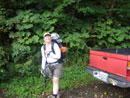
All Smiles |
First Washout |

White Chuck Road |
Third Washout |
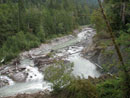
White Chuck River |
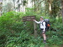
WC Bench Trail Sign |
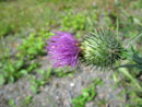
Thistle |
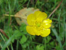
Yellow Flower |
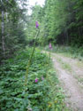
Rat Trap Pass Road |

Frog |
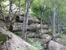
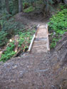
Retaining Wall |

Intersection |
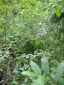
Brushy |

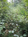
Less Brushy |
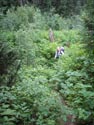
Brushier |
End Of The Road |
Crystal Creek Trail |
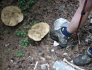
Mushrooms |
Near Crystal Lake |
On New Trail |

Crysstal Lake Camp |

New Pack |
New Trail |
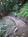
Kim On Bridge |
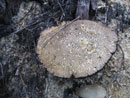
Huge Mushroom |
Photo Page 2
Trips - 2007
Home